
Evening update
4 PM Facebook live video link
https://wtalk.co/PVDBQMU9
3 PM update
Winter storm taking aim at portions of our region.
I put together a Facebook Live video. There are a few minutes where the mic did not work. Skip that part.
Link
https://wtalk.co/LDQWGMJ3
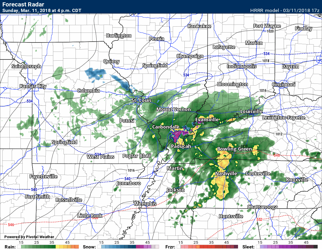
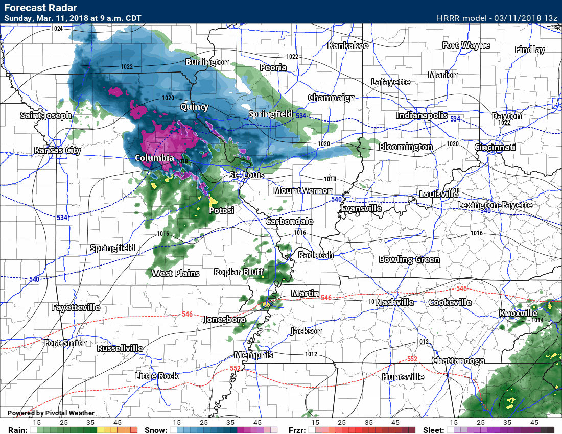
Here is the latest Hrrr model guidance.
Green is rain. Yellow is rain. Blue and purple would be snow. Heavy snow in purple. One model’s opinion.
No changes to the forecast.
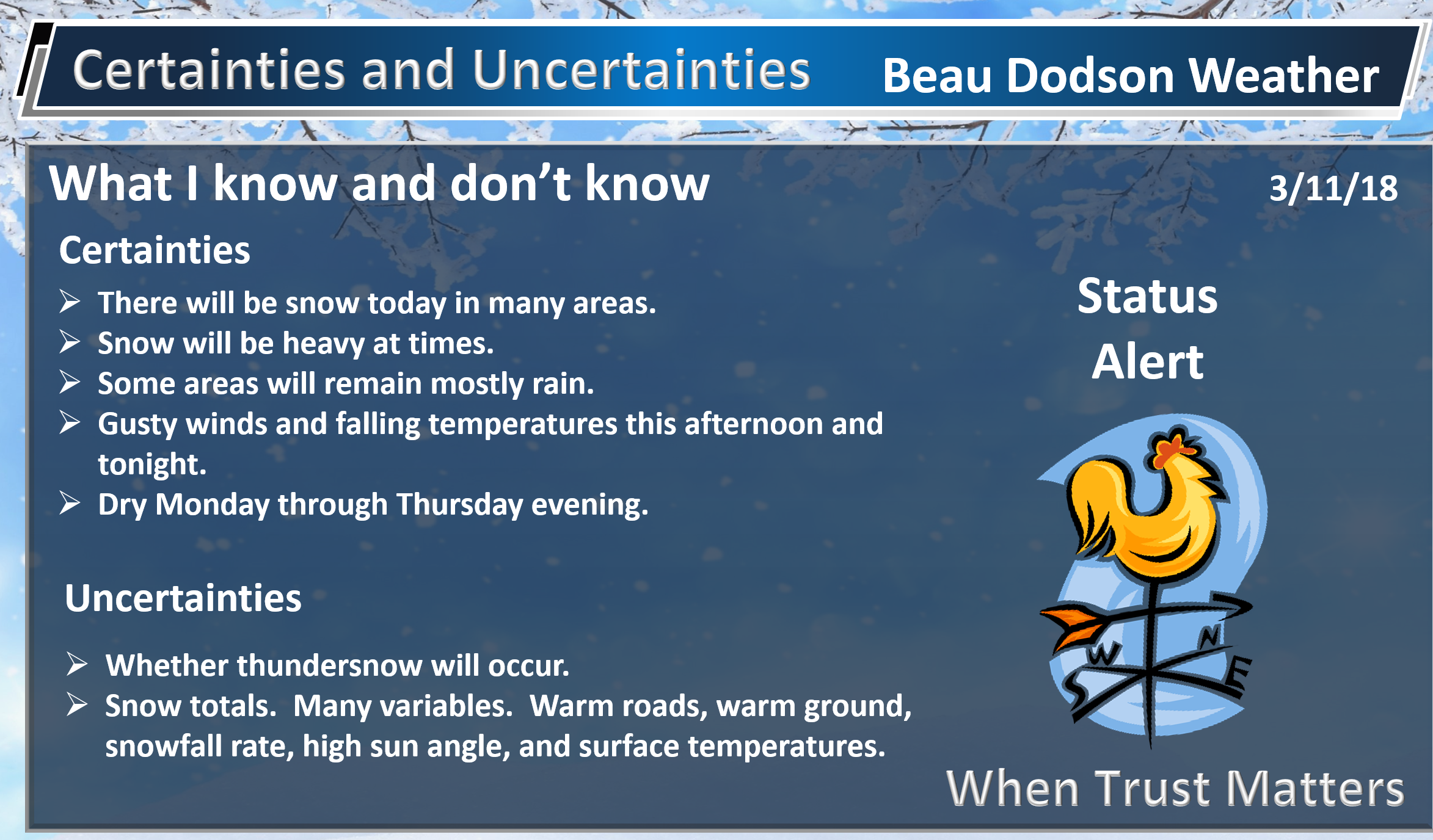
Snow is already being reported across portions of southern Illinois. Snow, sleet, and rain. The snow will take over later this afternoon and evening.
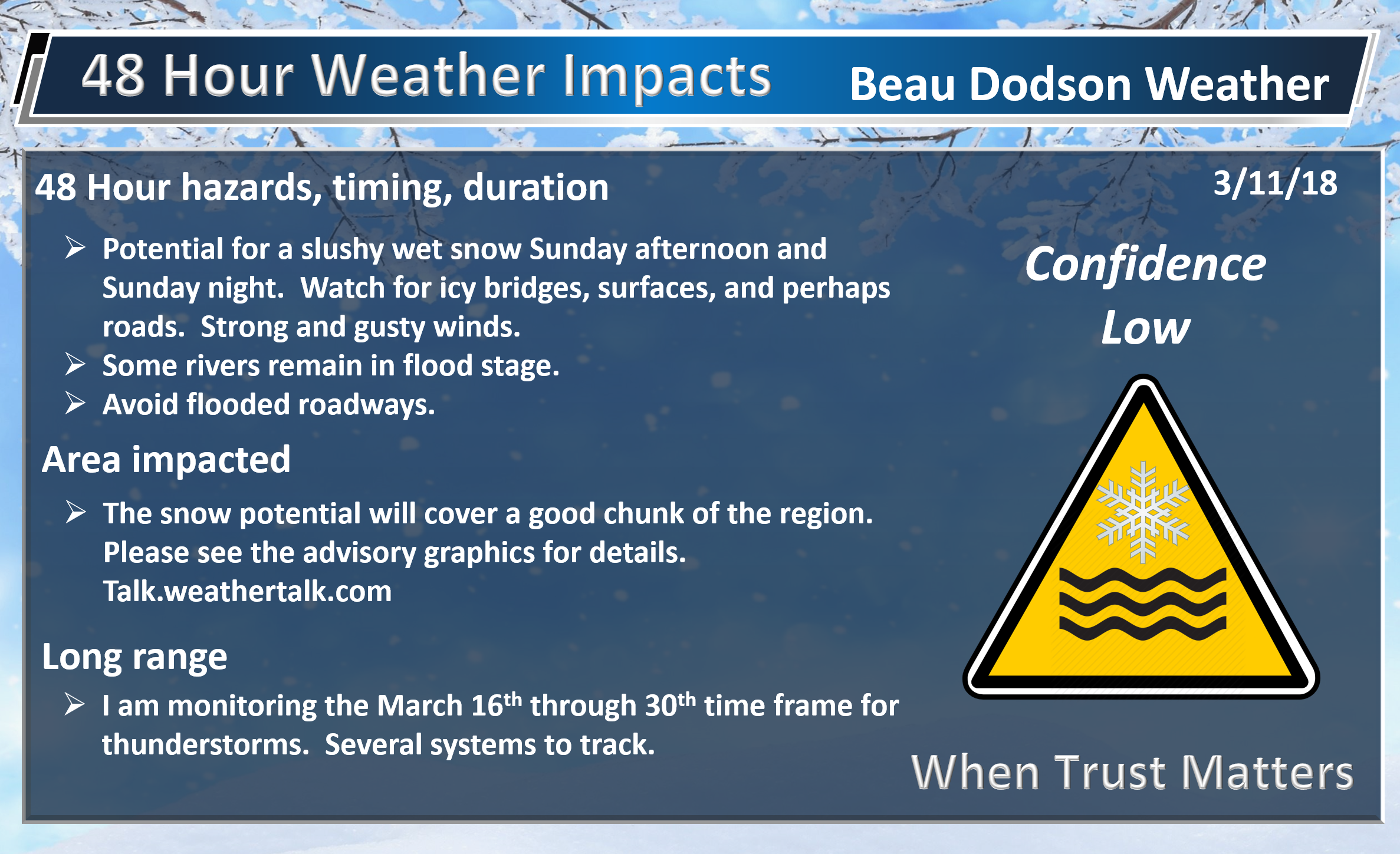
Remember, some of you will receive no snow accumulation. WHERE the snow develops we are looking at one to four inches. If banding occurs then four to eight inches will be possible. Just not sure on the banding.
Tough tough forecast with warm ground conditions. Not a slam dunk forecast. Low confidence on snow totals.

March 11, 2018
Sunday Forecast Details
Winter Storm Alert
A burst of heavy wet snow possible this afternoon into tonight.
Forecast: Cloudy. Scattered morning showers. Rain increasing from the northwest during the late morning and afternoon hours. Becoming windy. A rumble of thunder possible. Turning colder northwest to southeast. Late in the day the rain may mix with or change to heavy wet snow. Thundersnow possible. Some accumulation likely.
Temperatures: MO ~ 40 to 50 Temperatures may fall into the 30’s late in the day. IL ~ 40 to 46 Temperatures may fall into the 30’s late in the day. KY ~ 45 to 54 Turning colder late in the day. TN ~ 48 to 54
What is the chance of precipitation? MO ~ 40% before 12 PM and then increasing to 80% during the afternoon IL ~ 40% before 12 PM and then increasing to 80% during the afternoon KY ~ 40% before 12 PM and then increasing to 80% during the afternoon TN ~ 70%
Coverage of precipitation: Scattered during the morning hours. Increasing coverage during the afternoon.
Winds: North and northeast 6 to 12 mph with gusts to 35 mph
What impacts are anticipated from the weather? Wet roadways. Gusty winds. Lightning. Monitor snow chances. Roads are warm. Monitor snow rates. If snow rates are high enough to roads would become snow covered. Bridges freeze first. Tree branches may break if we have heavy wet snow.
My confidence in the forecast verifying: High confidence there will be precipitation. Low confidence on snow totals.
Is severe weather expected? No
The NWS defines severe weather as 58 mph wind or great, 1″ hail or larger, and/or tornadoes
Should I cancel my outdoor plans? Have a plan B and monitor updates
Sunday Night Forecast Details:
Winter Storm Alert
Forecast: Cloudy. Windy, Colder. Heavy wet snow likely. Thundersnow possible. Some areas may remain all rain. Snow accumulation is possible if the snow rate is high enough. Falling temperatures. Snow totals of 2 to 4 inches are possible, but confidence on totals is low. The guidance indicates the potential of much higher totals, as well. If banding occurs then 4 to 8+ inches of snow would be possible. Again, confidence in totals is LOW.
Temperatures: MO ~ 28 to 34 IL ~ 28 to 34 KY ~ 28 to 34 TN ~ 30 to 35
What is the chance of precipitation? MO ~ 60% IL ~ 80% KY ~ 90% TN ~ 80%
Coverage of precipitation: Numerous the first half of the night. Ending as the night wears on.
Winds: Becoming north and northeast winds at 8 to 16 mph with gusts to 35 mph
What impacts are anticipated from the weather? Wet roadways. Icy patches. Slushy snow accumulation. Lightning.
My confidence in the forecast verifying: High on the precipitation forecast. LOW confidence on the snow accumulation forecast.
Is severe weather expected? No
The NWS defines severe weather as 58 mph wind or great, 1″ hail or larger, and/or tornadoes
Should I cancel my outdoor plans? Have a plan B and monitor updates.
Sunset 6:58 PM
March 12, 2018
Monday Forecast Details
Forecast: Mostly sunny with a few passing clouds. Cooler. Breezy.
Temperatures: MO ~ 44 to 48 IL ~ 45 to 50 KY ~ 45 to 50 TN ~ 46 to 52
What is the chance of precipitation? MO ~ 0% IL ~ 0% KY ~ 0% TN ~ 0%
Coverage of precipitation: None
Winds: North and northwest at 10 to 20 mph
What impacts are anticipated from the weather? None
My confidence in the forecast verifying: Medium
Is severe weather expected? No
The NWS defines severe weather as 58 mph wind or great, 1″ hail or larger, and/or tornadoes
Should I cancel my outdoor plans? No
Sunrise 7:09 AM
Monday Night Forecast Details:
Forecast: Mostly clear and cool. Patchy fog possible.
Temperatures: MO ~ 26 to 34 IL ~ 26 to 34 KY ~ 28 to 34 TN ~ 30 to 35
What is the chance of precipitation? MO ~ 0% IL ~ 0% KY ~ 0% TN ~ 0%
Coverage of precipitation: None
Winds: North and northwest at 6 to 12 mph
What impacts are anticipated from the weather? Low visibility where fog occurs.
My confidence in the forecast verifying: High
Is severe weather expected? No
The NWS defines severe weather as 58 mph wind or great, 1″ hail or larger, and/or tornadoes
Should I cancel my outdoor plans? No
Sunset 6:58 PM
March 13, 2018
Tuesday Forecast Details
Forecast: Patchy morning fog. Mostly sunny.
Temperatures: MO ~ 44 to 48 IL ~ 42 to 46 KY ~ 44 to 48 TN ~ 45 to 50
What is the chance of precipitation? MO ~ 0% IL ~ 0% KY ~ 0% TN ~ 0%
Coverage of precipitation: None
Winds: North 5 to 10 mph
What impacts are anticipated from the weather? Low visibility in areas with fog early in the morning.
My confidence in the forecast verifying: High
Is severe weather expected? No
The NWS defines severe weather as 58 mph wind or great, 1″ hail or larger, and/or tornadoes
Should I cancel my outdoor plans? No
Sunrise 7:08 AM
Tuesday Night Forecast Details:
Forecast: Mostly clear and cool.
Temperatures: MO ~ 24 to 28 IL ~ 24 to 28 KY ~ 24 to 28 TN ~ 24 to 28
What is the chance of precipitation? MO ~ 0% IL ~ 0% KY ~ 0% TN ~ 0%
Coverage of precipitation: None
Winds: North 4 to 8 mph
What impacts are anticipated from the weather? None
My confidence in the forecast verifying: High
Is severe weather expected? No
The NWS defines severe weather as 58 mph wind or great, 1″ hail or larger, and/or tornadoes
Should I cancel my outdoor plans? No
Sunset 6:59 PM
March 14, 2018
Wednesday Forecast Details
Forecast: Mostly sunny. Cool.
Temperatures: MO ~ 45 to 50 IL ~ 45 to 50 KY ~ 45 to 50 TN ~ 46 to 52
What is the chance of precipitation? MO ~ 0% IL ~ 0% KY ~ 0% TN ~ 0%
Coverage of precipitation: None
Winds: West and northwest 5 to 10 mph
What impacts are anticipated from the weather? None
My confidence in the forecast verifying: High
Is severe weather expected? No
The NWS defines severe weather as 58 mph wind or great, 1″ hail or larger, and/or tornadoes
Should I cancel my outdoor plans? No
Sunrise 7:06 AM
Wednesday Night Forecast Details:
Forecast: Mostly clear and cool.
Temperatures: MO ~ 28 to 34 IL ~ 28 to 34 KY ~ 28 to 34 TN ~ 30 to 35
What is the chance of precipitation? MO ~ 0% IL ~ 0% KY ~ 0% TN ~ 0%
Coverage of precipitation: None
Winds: West and northwest at 5 mph
What impacts are anticipated from the weather? None
My confidence in the forecast verifying: High
Is severe weather expected? No
The NWS defines severe weather as 58 mph wind or great, 1″ hail or larger, and/or tornadoes
Should I cancel my outdoor plans? No
Sunset 7:00 PM
March 15, 2018
Thursday Forecast Details
Forecast: Mostly sunny. Milder.
Temperatures: MO ~ 56 t0 62 IL ~ 56 to 62 KY ~ 56 to 62 TN ~ 56 to 62
What is the chance of precipitation? MO ~ 0% IL ~ 0% KY ~ 0% TN ~ 0%
Coverage of precipitation: None
Winds: West and southwest 7 to 14 mph
What impacts are anticipated from the weather? None
My confidence in the forecast verifying: High
Is severe weather expected? No
The NWS defines severe weather as 58 mph wind or great, 1″ hail or larger, and/or tornadoes
Should I cancel my outdoor plans? No
Sunrise 7:05 AM
Thursday Night Forecast Details:
Forecast: Mostly clear early. A few late night clouds. A slight chance of a shower after midnight.
Temperatures: MO ~ 44 to 48 IL ~ 44 to 48 KY ~ 44 to 46 TN ~ 44 to 48
What is the chance of precipitation? MO ~ 0% IL ~ 0% KY ~ 0% TN ~ 0%
Coverage of precipitation: None
Winds: South at 5 to 10 mph
What impacts are anticipated from the weather? None
My confidence in the forecast verifying: High
Is severe weather expected? No
The NWS defines severe weather as 58 mph wind or great, 1″ hail or larger, and/or tornadoes
Should I cancel my outdoor plans? No
Sunset 7:01 PM

Questions? Broken links? Other?
You may email me at beaudodson@usawx.com

The National Weather Service defines a severe thunderstorm as one that produces quarter size hail or larger, 58 mph winds or greater, and/or a tornado.
Today and tonight: Lightning is possible today. Thundersnow is possible late this afternoon and tonight. Lightning is the main concern.
Monday through Thursday night: Severe weather is not anticipated.
![]()
Interactive live weather radar page. Choose the city nearest your location. If one of the cities does not work then try a nearby one. Click here.
National map of weather watches and warnings. Click here.
Storm Prediction Center. Click here.
Weather Prediction Center. Click here.

Live lightning data: Click here.

Interactive GOES R satellite. Track clouds. Click here.

Here are the latest local river stage forecast numbers Click Here.
Here are the latest lake stage forecast numbers for Kentucky Lake and Lake Barkley Click Here.

The spring and preliminary summer outlooks have been posted for subscribers. Scroll down to see the outlook.
Not a subscriber? Learn more at this link.

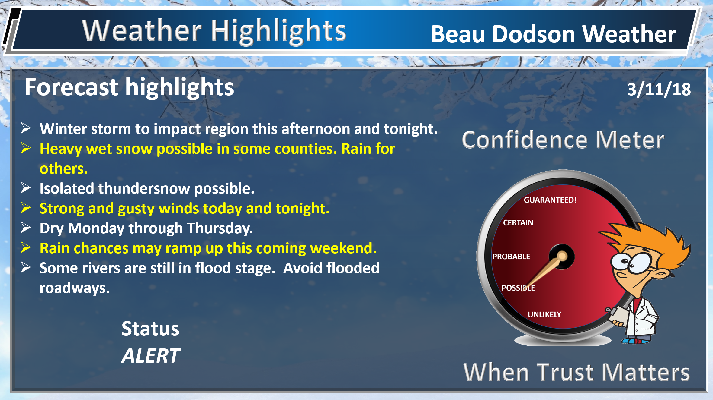
WEATHER HIGHLIGHTS
- Showers this morning. Isolated thunderstorm.
- Rain may change to wet snow Sunday afternoon (late) or Sunday night. Some accumulation possible. Heavy wet snow in some areas.
- Strong and gusty winds today and tonight.
- Cold temperatures begin the new work week. A slow warming trend as we move towards the middle/end of the week.
- Flooding will continue to be an issue in some areas. Avoid flooded roadways.
- In case you missed it! Here is the Facebook thread with some exciting new announcements concerning Weather Talk. Click here to read that.
Highlights
What has changed over the last 24 hours?
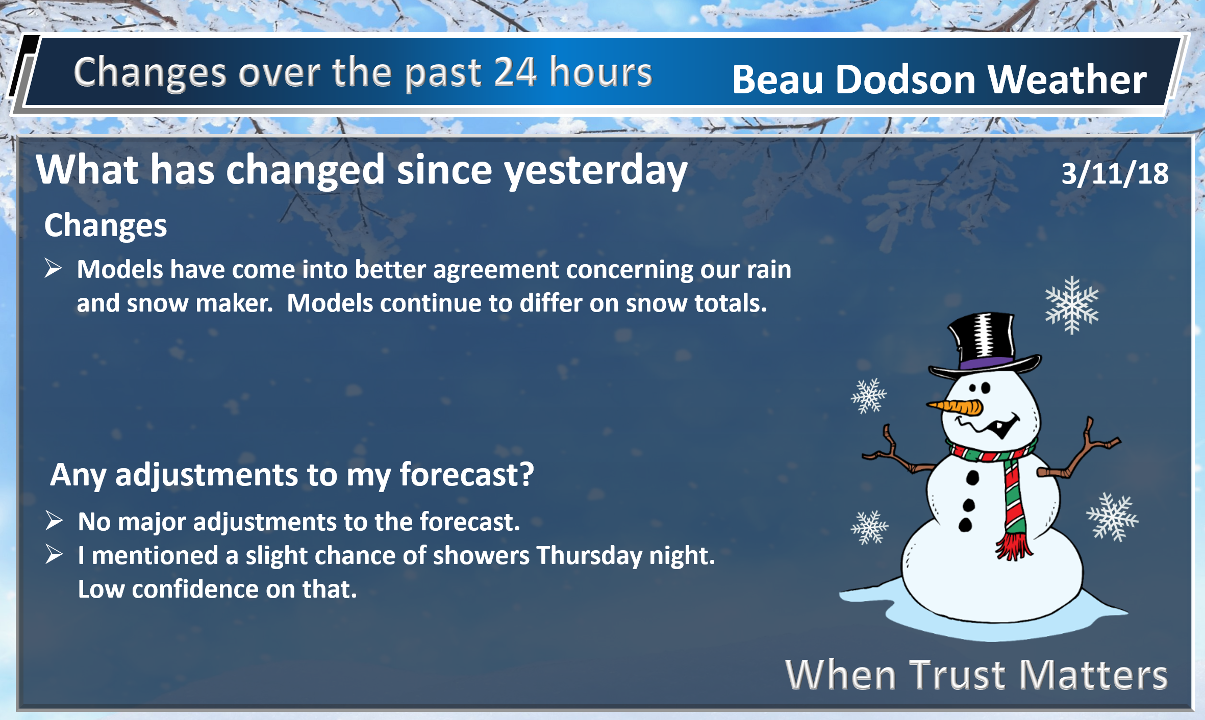
Weather Hazards.
What I know and don’t know
I am always looking for reports. Beaudodson@usawx.com or Twitter @beaudodson (photos welcome)

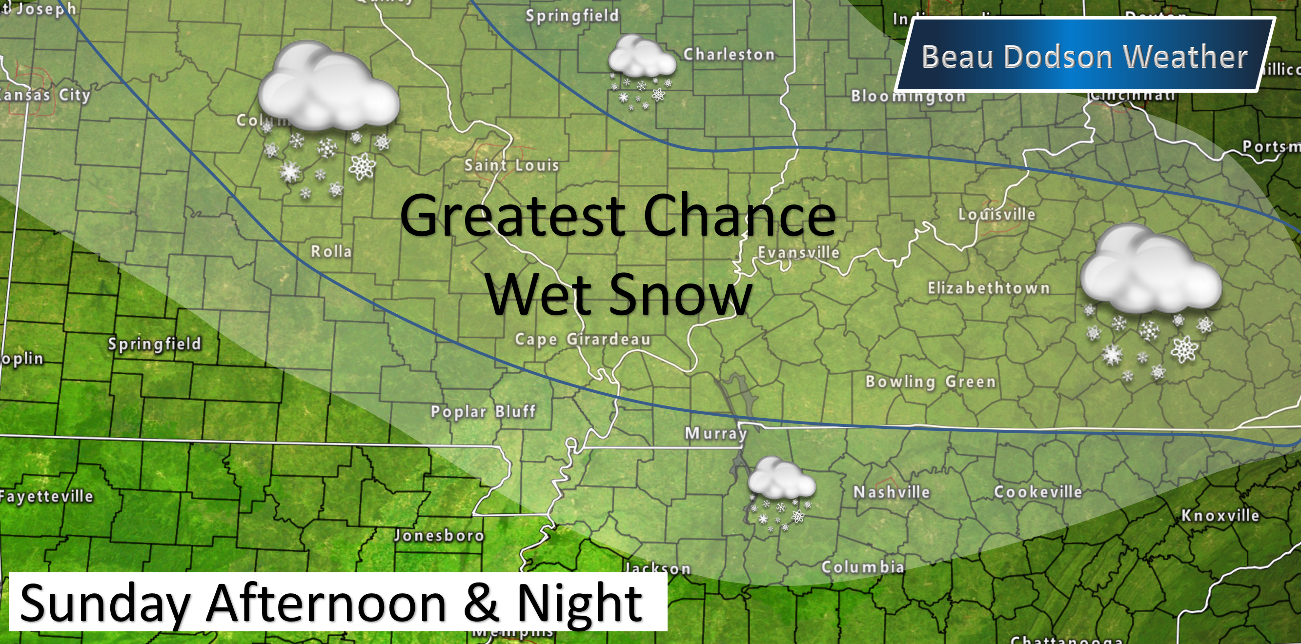
The greatest chance of wet snow.

Interactive live weather radar page. Choose the city nearest your location. If one of the cities does not work then try a nearby one. Click here.
Don’t forget you can turn on winter precipitation mode. This is on the local city-view radars.
Example
The focus of this update centers around rain and snow chances today and tonight.
I told everyone we were likely not finished with snow this winter. Nature is about to throw us a curve ball. I know many of you are ready for spring. Patience. We will get there.
A late season winter storm is developing over Missouri and Illinois. This winter storm will merge with another system to our south.
As these two systems merge an area of low pressure will develop. This low-pressure center will then move to our southeast. This places us on the cold side of the event.
These systems will produce widespread precipitation developing today, especially this afternoon. The precipitation will continue into tonight.
Colder air will push into the region from the north and west as we move through today and tonight. Temperatures aloft will be well below freezing.
As heavy rain develops the colder air aloft will start to push downward. We call this dynamic cooler. As snowflakes fall they will cool the air around them. Eventually, the rain will change to heavy wet snow.
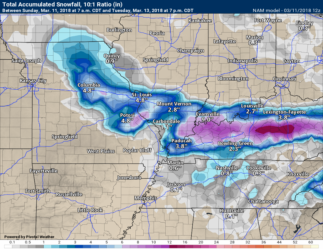
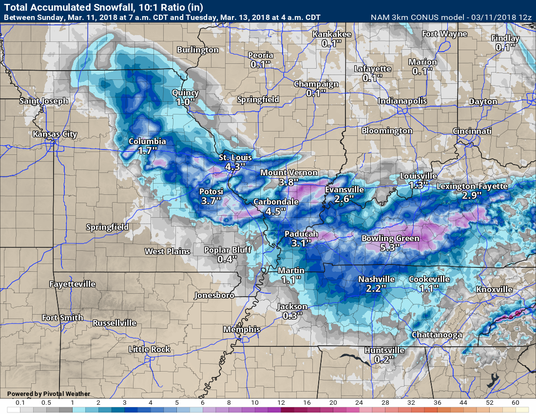
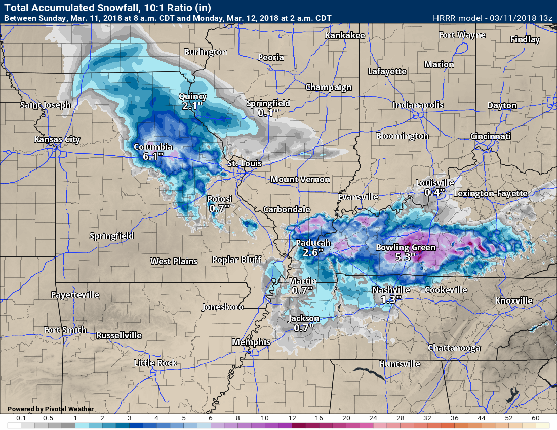
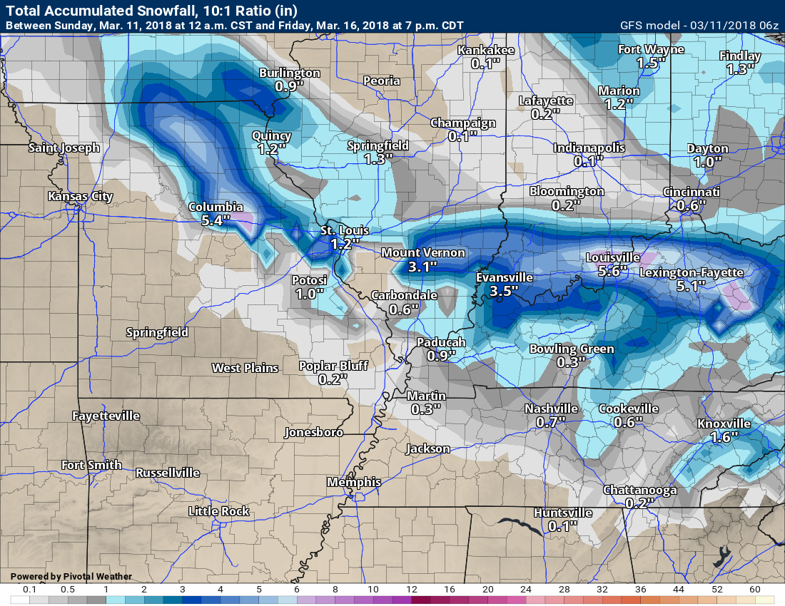
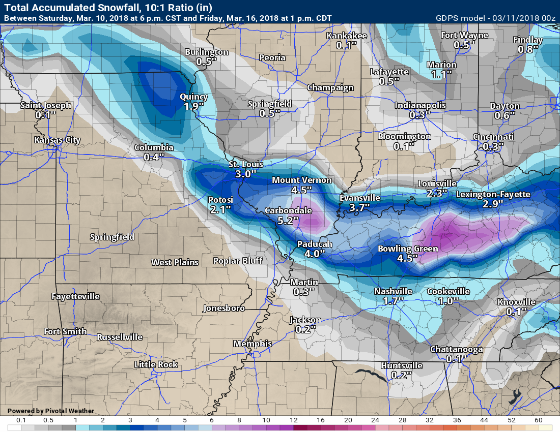
There is the potential of heavy wet snow from this event. Model guidance generally shows one to four inches of snow, but if banding occurs then snow totals of four to eight inches would be possible. This is a tough forecast and not a slam dunk forecast.
Snow rates of one to two inches per hour are possible in the heaviest snow bands.
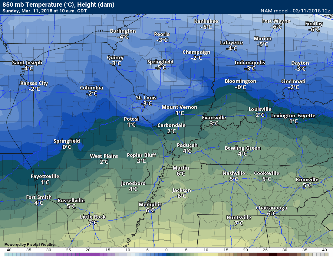
The NAM guidance shows temperatures aloft at or below freezing. That is a signal that rain could change to snow.
These numbers are Celcius.
Sunday 850 MB temperatures (several thousand feet aloft). These are the cold temperatures aloft. This is from this morning through tonight. Notice the colder air aloft moving southeast through our region. Where the precipitation occurs with these cold temperatures aloft is key to whether you have all rain or rain changing to snow.
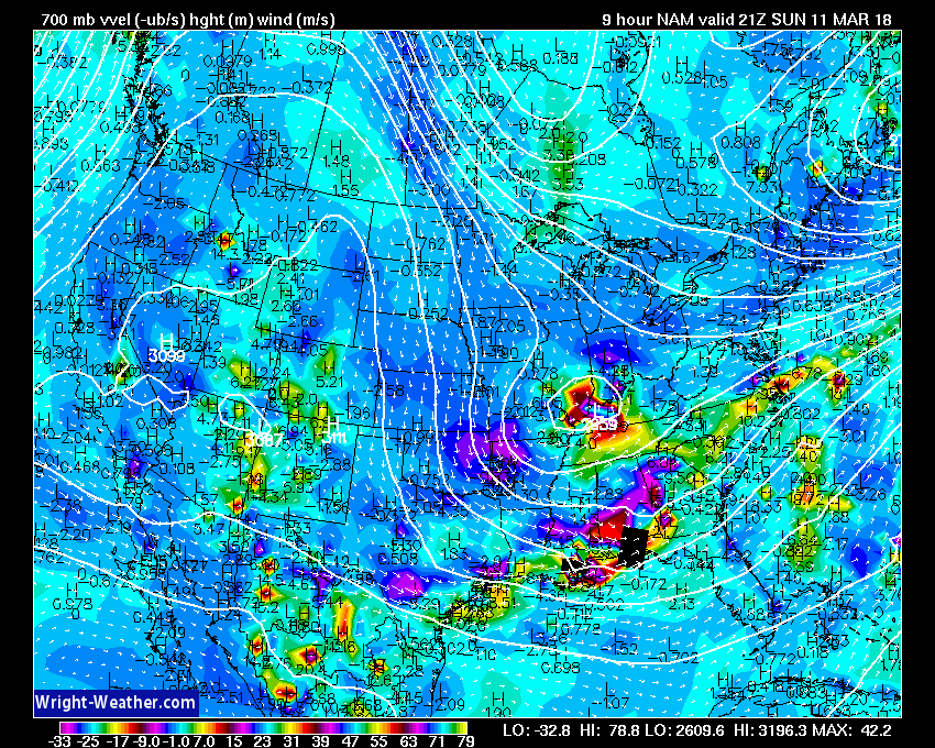
Now let’s look at lift. Lift helps produce precipitation.
A strong vort max (area of lift) pushes through our region Sunday afternoon and night. This will enhance precipitation rates. A burst of heavier precipitation should occur as the upper-level system develops over our region and moves east/southeast.
That burst of heavier precipitation is what could drag colder air downward. That would change the rain to wet snow.
Those bright colors represent strong vertical motion. Lightning? Certainly possible.
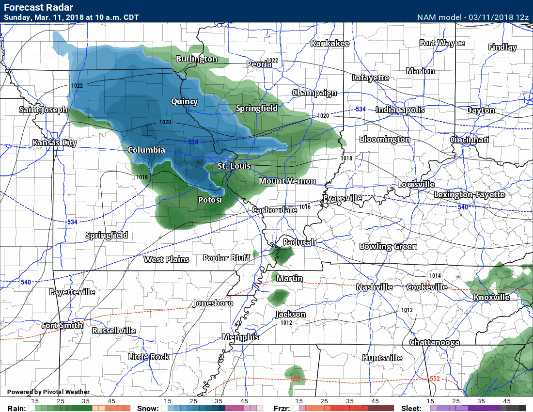
Let’s look at the NAM guidance future-cast radar. This takes us through Sunday night.
The snow portion of the forecast is risky. Lower than normal confidence in the potential of snow.
We should have some rain showers in the region Sunday morning. As we move into Sunday afternoon, additional rain would then move into the region from northwest to southeast. It is this second system that would produce the snow.
Timestamp upper left.
Green represents rain. Blue represents snow.
Do not get caught up in where this model shows green or blue. It won’t be exact and there remain a lot of questions about where the greatest potential of snow would be. Take the general idea from these maps. What is the general idea? That some wet snow is possible late Sunday into Sunday night.
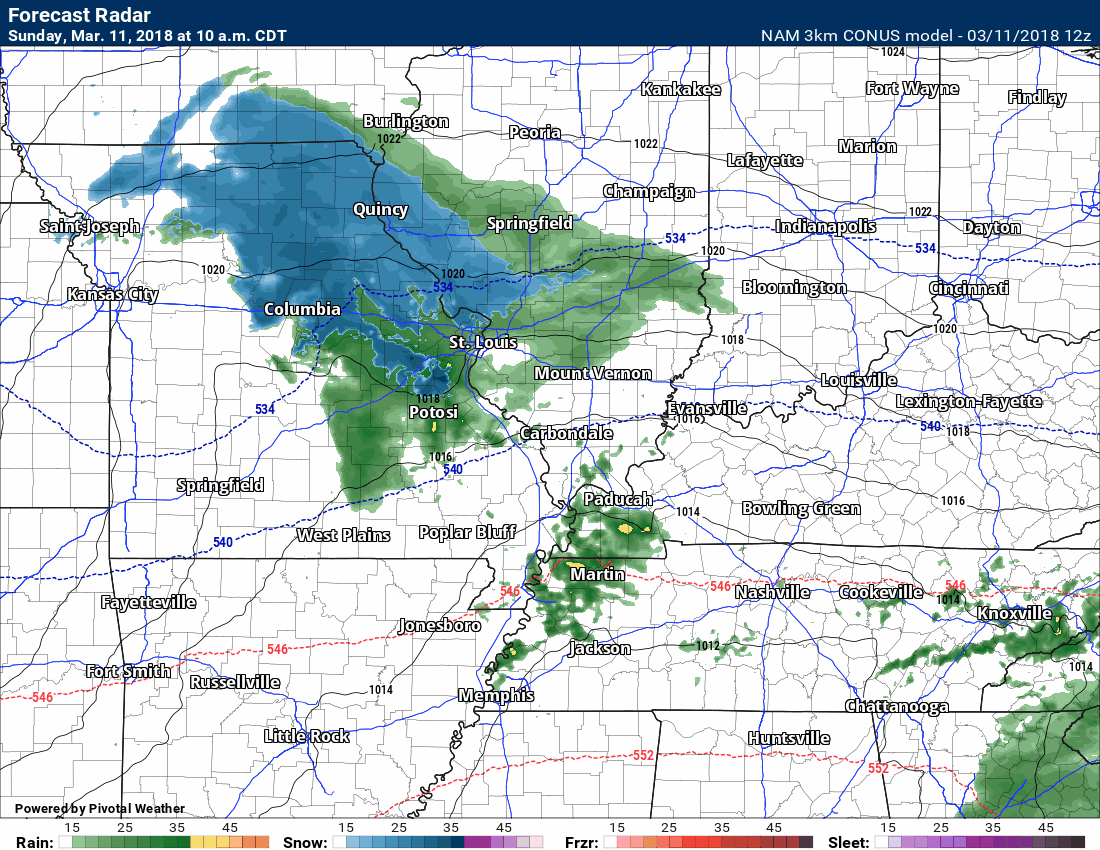
Here is the NAM 3K high-resolution model (same model but higher resolution). Future-cast radar.
Again, green is rain and blue would be snow.
Timestamp upper left.
Here is the Hrrr high-resolution model.
Future-cast radar.
Again, green is rain and blue would be snow.
Timestamp upper left
How much snow could accumulate?
Difficult to say. Surface temperatures will initially be above freezing. Road and ground temperatures are well above freezing.
It would have to snow at a heavy pace in order to overcome these obstacles. Is it possible? Yes, absolutely possible. Will it occur? Well, that is the million dollar forecast question.
Temperatures, Sunday night into Monday morning, may drop into the upper 20’s and lower 30’s. If that occurs, then there could be some issues. This is especially true if heavy wet snow does indeed develop.
A dusting to four inches of snow is likely across areas where rain does change to snow. There is the potential of double those amounts if banding occurs.
Here are what the models are showing. Take these with a grain of salt.
Models struggle with snow totals in a normal snow event. With an event like this, they struggle even more.
NAM Model
NAM 3K Model
Hrrr Model
GFS Model
Canadian Model
European Model

Monitor updated forecasts.
It will be dry Monday through Thursday night! That is the great news.

Weather Brains is a weekly podcast/video for those who love weather and want more!
Weather Brains episode number 633
Previous episodes can be viewed by clicking here.
t’s a full house for this episode of WeatherBrains with representatives from a number of weather-related podcasts. Joining us are Becky DePodwin, Ice Station Housman, Scotty Powell from Carolina Weather Gang, Castle Williams,
WeatherHype
, Mark Jelinek, What is it About the Weather, and Phil Johnson of Storm Front Freaks Podcast. This show marks National Weather Podcast Month.
Other discussions in this weekly podcast include topics like:
- Extremes: 98 at Rio Grande Village, TX, and -7 at Cut Bank, MT
- The creative outlet that is podcasts and how they have changed over time
- The importance of providing good content in podcasting
- 25th Anniversary of Blizzard of 1993
- Astronomy Outlook with Tony Rice
- and more!
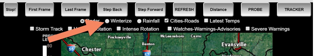
We offer interactive local city live radars and regional radars. If a radar does not update then try another one. If a radar does not appear to be refreshing then hit Ctrl F5. You may also try restarting your browser.
The local city view radars also have clickable warnings.
During the winter months, you can track snow and ice by clicking the winterize button on the local city view interactive radars.
You may email me at beaudodson@usawx.com
Find me on Facebook!

Find me on Twitter!

Did you know that a portion of your monthly subscription helps support local charity projects?
You can learn more about those projects by visiting the Shadow Angel Foundation website and the Beau Dodson News website.

I encourage subscribers to use the app vs regular text messaging. We have found text messaging to be delayed during severe weather. The app typically will receive the messages instantly. I recommend people have three to four methods of receiving their severe weather information.
Remember, my app and text alerts are hand typed and not computer generated. You are being given personal attention during significant weather events.
