A flash flood watch has been issued from Friday evening into Sunday morning.
The main concern will be heavy rain. A widespread one to three-inch rain is forecast with pockets of three to six inches.
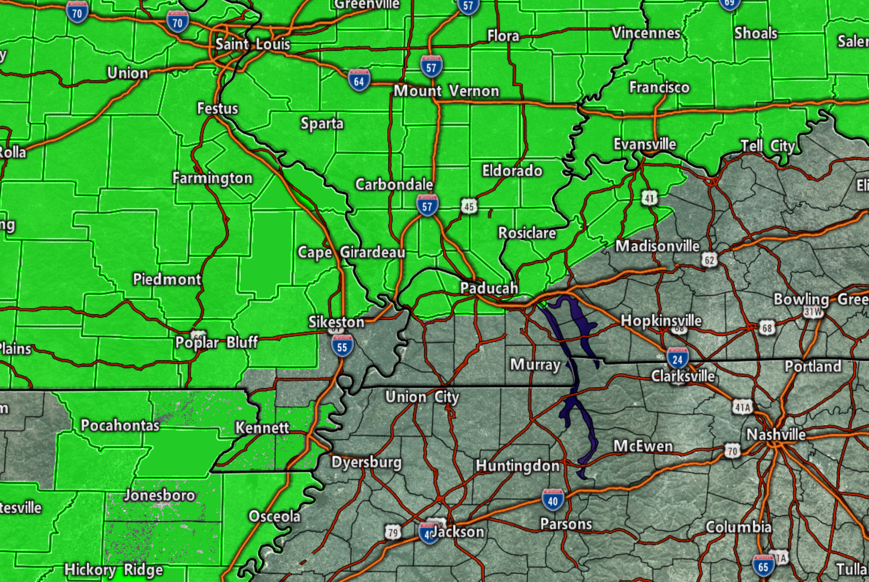
The watch is the area in green.
Areas outside of the watch may also experience heavy rain.
The watch zone is where totals are anticipated to be highest.
I also wanted to note that areas around LBL and then along the KY/TN border could receive quite a bit less rain than other areas. That is something that keeps showing up in the data.
There will be a variety of totals, as always.
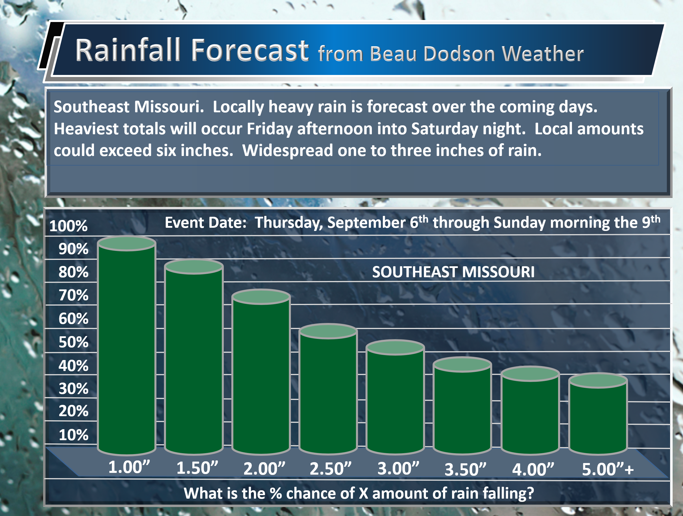
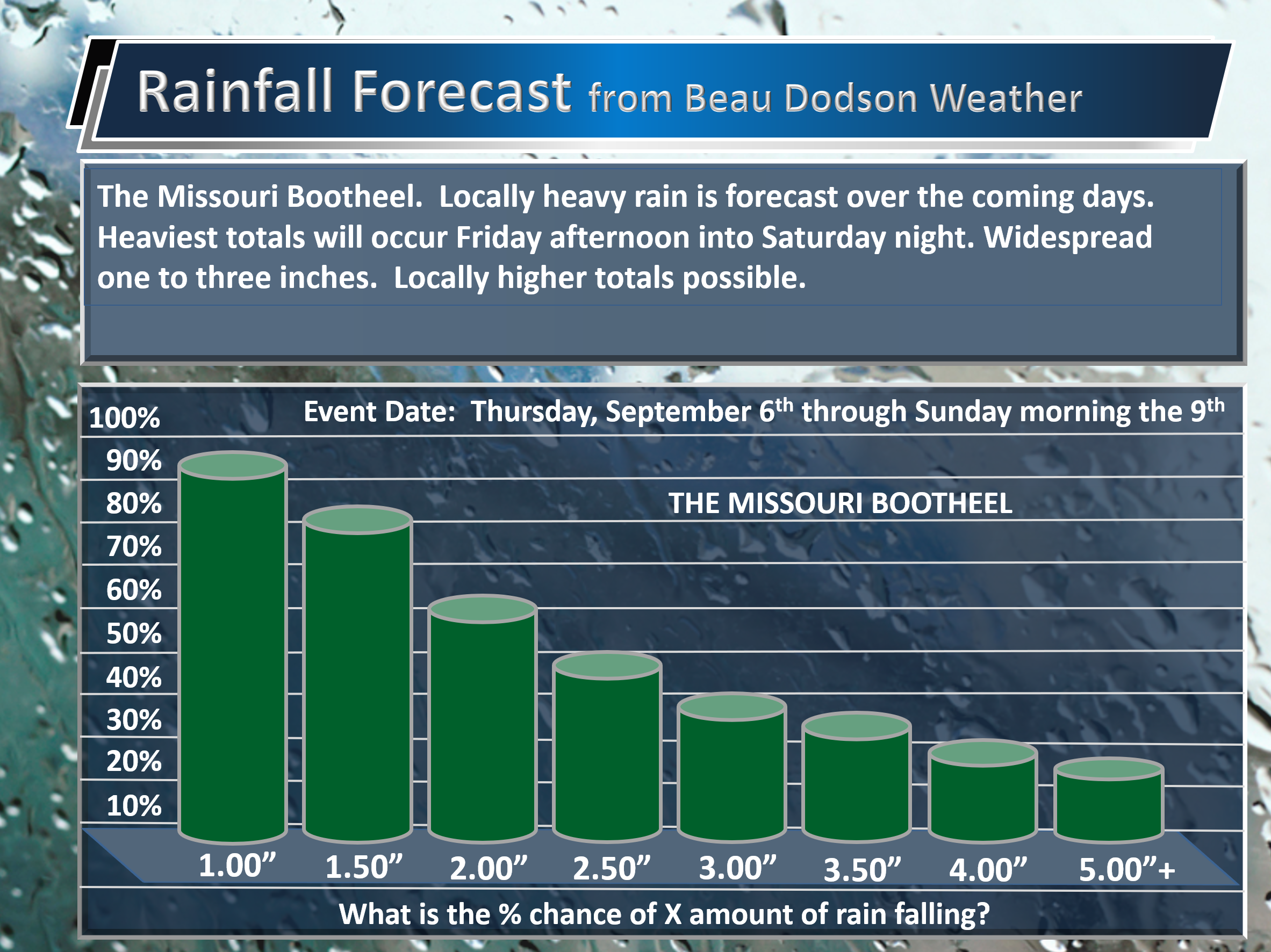
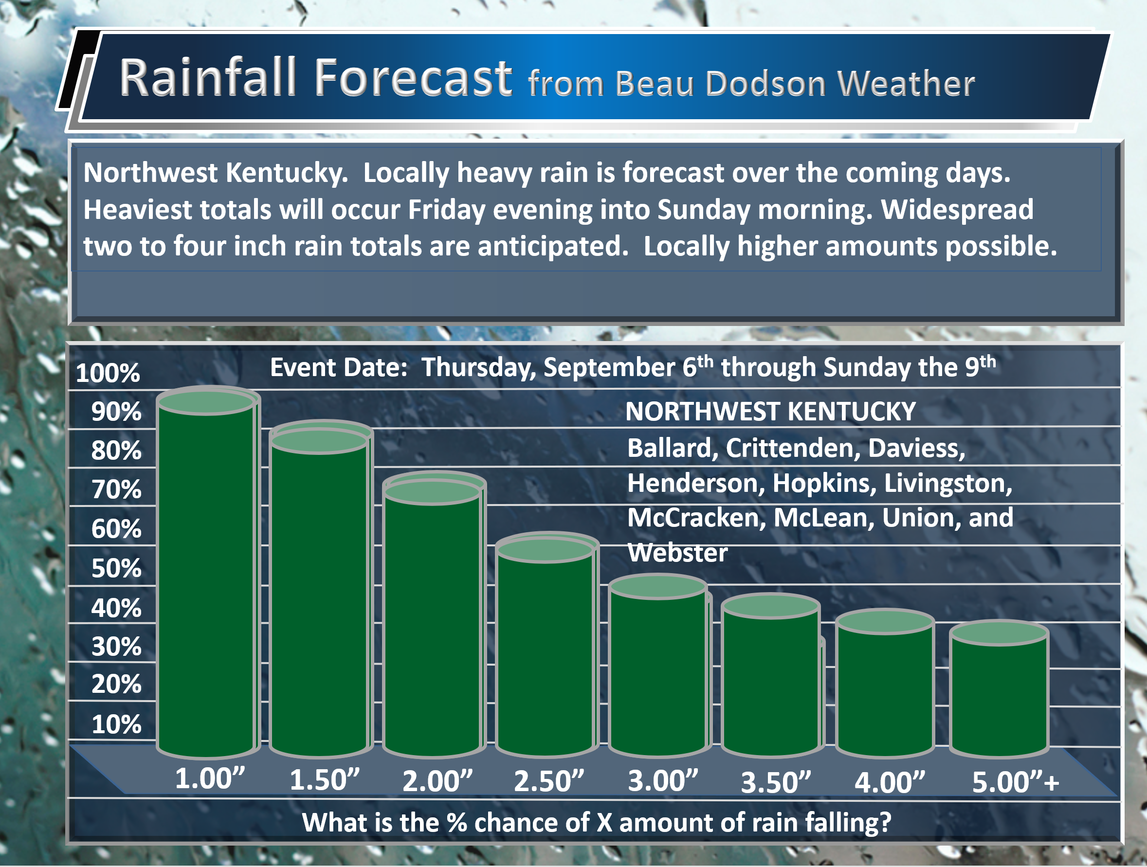
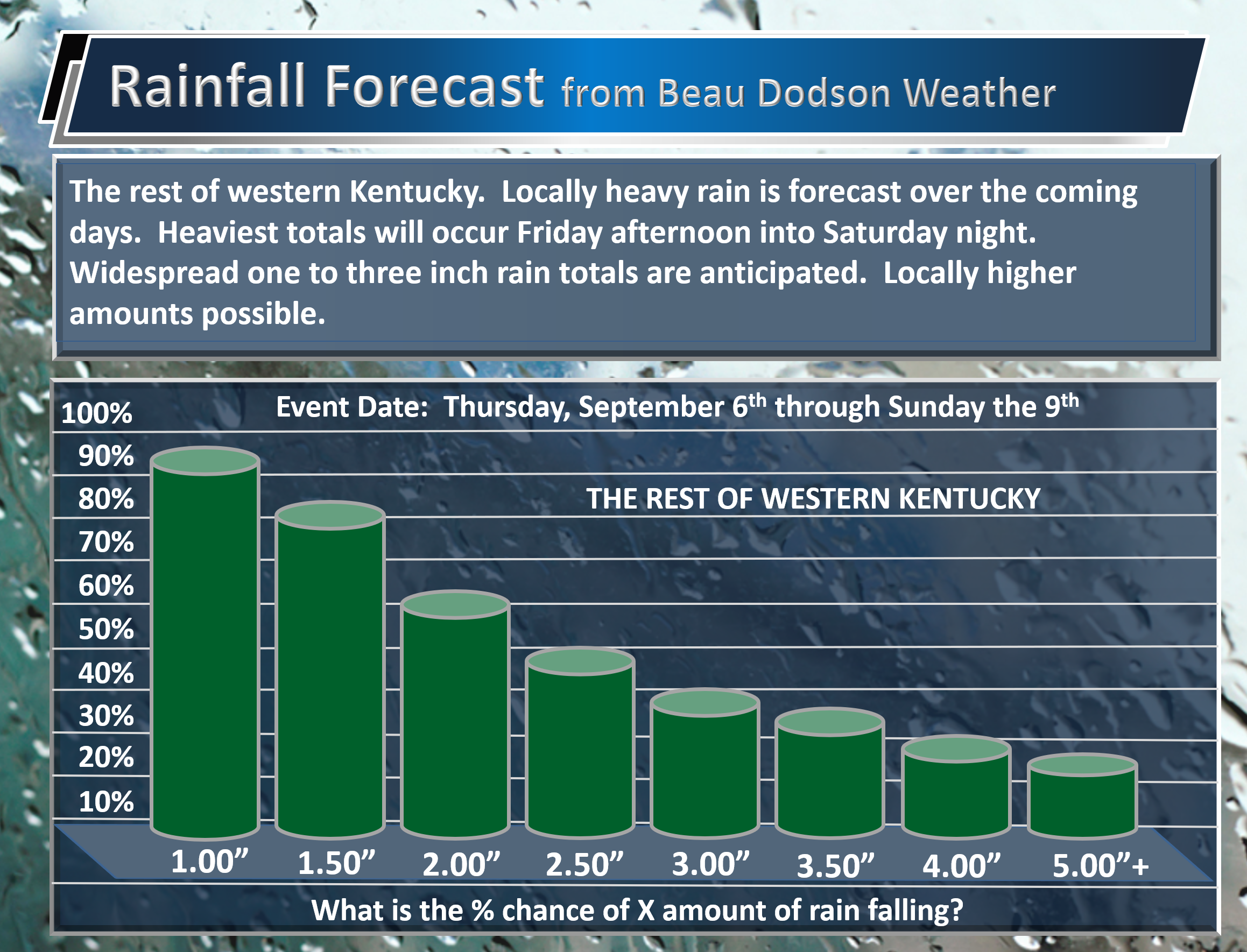
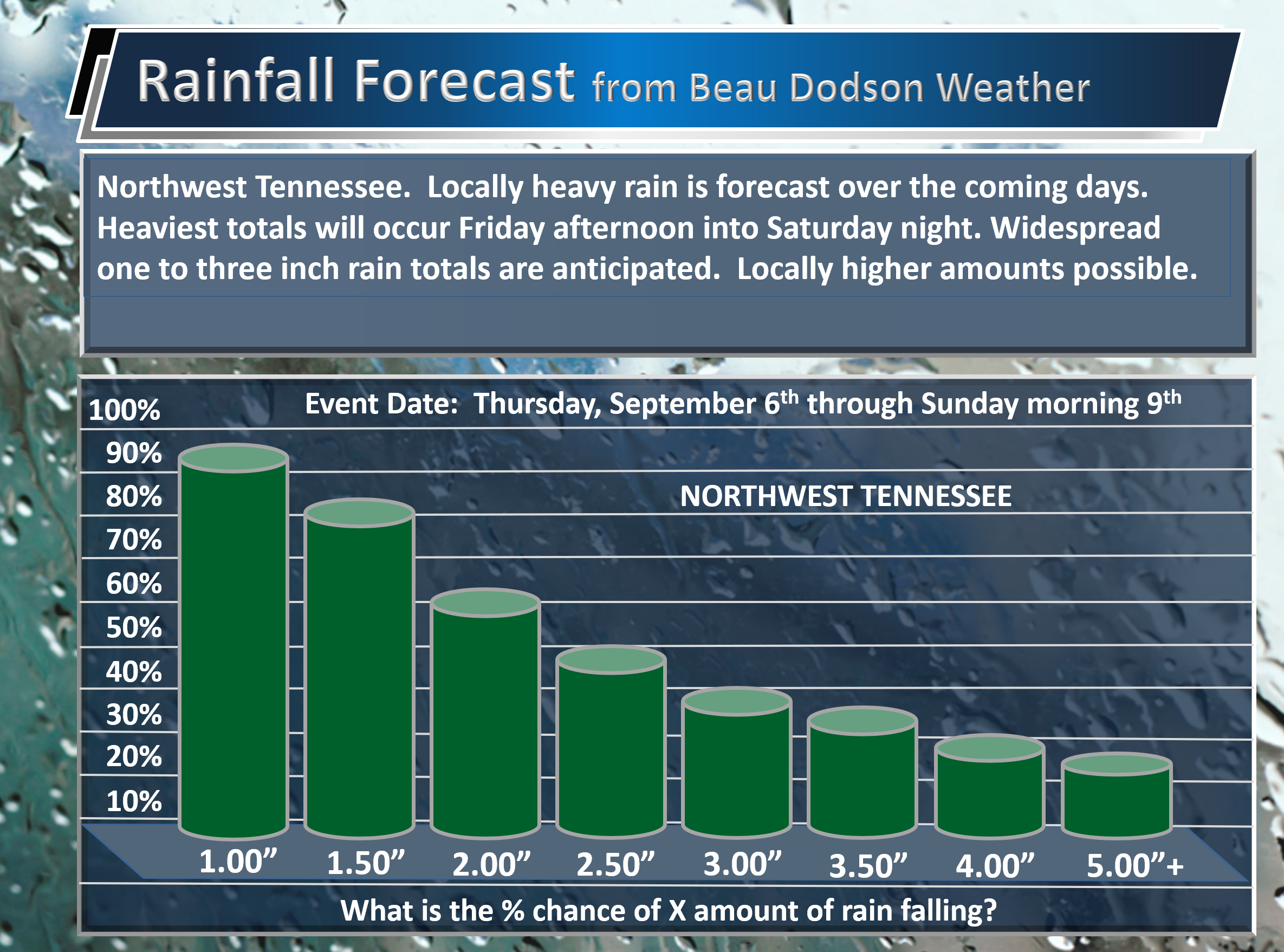
Here are my current rainfall projections numbers. These graphics show you the probability of X amount of rain falling.
Southeast Missouri
The Missouri Bootheel
Southern Illinois

Northwest Kentucky
The rest of western Kentucky
Northwest Tennessee
WeatherTalk monthly operating costs can top $2000.00. Your $5 subscription helps pay for those costs. I work for you.
The $5 will allow you to register up to seven phones!
For $5 a month you can receive the following. You may choose to receive these via your WeatherTalk app or regular text messaging.
Severe weather app/text alerts from my keyboard to your app/cell phone. These are hand typed messages from me to you. During tornado outbreaks, you will receive numerous app/text messages telling you exactly where the tornado is located.
- Daily forecast app/texts from my computer to your app/cell phone.
- Social media links sent directly to your app/cell phone. When I update the blog, videos, or Facebook you will receive the link.
- AWARE emails. These emails keep you well ahead of the storm. They give you several days of lead time before significant weather events.
- Direct access to Beau via text and email. Your very own personal meteorologist. I work for you!
- Missouri and Ohio Valley centered video updates
- Long-range weather videos
- Week one, two, three and four temperature and precipitation outlooks.
Monthly outlooks. - Your subscription also will help support several local charities.
Would you like to subscribe? Subscribe at www.beaudodsonweather.com

I encourage subscribers to use the app vs regular text messaging. We have found text messaging to be delayed during severe weather. The app typically will receive the messages instantly. I recommend people have three to four methods of receiving their severe weather information.
Remember, my app and text alerts are hand typed and not computer generated. You are being given my personal attention during significant weather events.

WWW.WEATHERTALK.COM subscribers, here is my day to day schedule for your weather products.
These are bonus videos and maps for subscribers. I bring these to you from the BAMwx team. I pay them to help with videos.
The Ohio and Missouri Valley videos cover most of our area. They do not have a specific Tennessee Valley forecast but may add one in the future.
The long-range video is technical. Over time, you can learn a lot about meteorology from the long range video. Just keep in mind, it is a bit more technical.


September 6, 2018
Thursday Forecast Details
Forecast: Partly to mostly cloudy. Scattered showers and a few thunderstorms possible.
Temperatures: MO ~ 82 to 86 IL ~ 84 to 88 KY ~ 84 to 88 TN ~ 84 to 88
What is the chance of precipitation? MO ~ 50% to 60% IL ~ 40% to 50% KY ~ 40% to 50% TN ~ 40% to 50%
Wind: East and southeast at 6 to 14 mph with gusts to 20 mph
What impacts are anticipated from the weather? Scattered wet roadways. Lightning.
My confidence in the forecast verifying: High
Is severe weather expected? No
The NWS defines severe weather as 58 mph wind or great, 1″ hail or larger, and/or tornadoes
Should I cancel my outdoor plans? No, but check radars
UV Index: 4 to 6 Low to moderate (we will have to monitor cloud cover)
Sunrise: 6:30 AM
Thursday Night Forecast Details:
Forecast: Mostly cloudy. Warm. Humid. Scattered showers and perhaps a thunderstorm.
Temperatures: MO ~ 70 to 74 IL ~ 70 to 74 KY ~ 70 to 74 TN ~ 70 to 74
What is the chance of precipitation? MO ~ 60% IL ~ 40% KY ~ 40% TN ~ 40%
Coverage of precipitation: Scattered
Wind: East and southeast at 6 to 12 mph with gusts to 18
What impacts are anticipated from the weather? Wet roadways. Lightning.
My confidence in the forecast verifying: High
Is severe weather expected? No
The NWS defines severe weather as 58 mph wind or great, 1″ hail or larger, and/or tornadoes
Should I cancel my outdoor plans? No, but check radars
Sunset: 7:16 PM
Moonrise: 2:42 AM Waning Crescent
Moonset: 5:21 PM
September 7, 2018
Friday Forecast Details
Forecast: Mostly cloudy. Showers likely. Some thunderstorms possible. Greatest chance will be during the afternoon. Locally heavy rain.
Temperatures: MO ~ 78 to 84 IL ~ 78 to 84 KY ~ 84 to 86 TN ~ 84 to 88
What is the chance of precipitation? MO ~ 70% IL ~ 70% KY ~ 60% TN ~ 60%
Coverage of precipitation: Perhaps numerous
Wind: East and southeast at 8 to 14 mph
What impacts are anticipated from the weather? Wet roadways and scattered lightning. Locally heavy rain could cause flash flooding in a few locations.
My confidence in the forecast verifying: Medium
Is severe weather expected? Monitor updates.
The NWS defines severe weather as 58 mph wind or great, 1″ hail or larger, and/or tornadoes
Should I cancel my outdoor plans? Have a plan B and monitor radars and updates
UV Index: 3 to 4 Low
Sunrise: 6:31 AM
Friday Night Forecast Details:
Forecast: Showers and a few thunderstorms. Locally heavy rain.
Temperatures: MO ~ 70 to 74 IL ~ 70 to 74 KY ~ 70 to 74 TN ~ 70 to 74
What is the chance of precipitation? MO ~ 80% IL ~ 80% KY ~ 70% TN ~ 70%
Coverage of precipitation: Numerous
Wind: East and southeast becoming south at 8 to 16 mph
What impacts are anticipated from the weather? Wet roadways and scattered lightning. Locally heavy rain could cause flash flooding in a few locations.
My confidence in the forecast verifying: Medium
Is severe weather expected? Unlikely, but monitor updates
The NWS defines severe weather as 58 mph wind or great, 1″ hail or larger, and/or tornadoes
Should I cancel my outdoor plans? Have a plan B and monitor radars and updates
Sunset: 7:15 AM
Moonrise: 3:50 AM Waning Crescent
Moonset: 6:11 PM
September 8, 2018
Saturday Forecast Details
Forecast: Showers and a few thunderstorms. Locally heavy rain.
Temperatures: MO ~76 to 82 IL ~ 76 to 82 KY ~ 80 to 85 TN ~ 80 to 85
What is the chance of precipitation? MO ~ 90% IL ~ 90% KY ~ 90% TN ~ 90%
Coverage of precipitation: Widespread
Wind: East and southeast at 6 to 14 mph with gusts to 20 mph
What impacts are anticipated from the weather? Wet roadways and scattered lightning. Locally heavy rain could cause flash flooding in a few locations.
My confidence in the forecast verifying: Medium
Is severe weather expected? Unlikely, but monitor updates
The NWS defines severe weather as 58 mph wind or great, 1″ hail or larger, and/or tornadoes
Should I cancel my outdoor plans? Have a plan B and monitor radars and updates
UV Index: 2 to 4 Low
Sunrise: 6:32 AM
Saturday Night Forecast Details:
Forecast: Showers and a few thunderstorms. Locally heavy rain likely.
Temperatures: MO ~ 65 to 70 IL ~ 65 to 70 KY ~ 65 to 70 TN ~ 68 to 72
What is the chance of precipitation? MO ~ 70% IL ~ 80% KY ~ 80% TN ~ 80%
Coverage of precipitation: Widespread
Wind: East and southeast wind at 8 to 16 mph
What impacts are anticipated from the weather? Wet roadways and lightning. Locally heavy rain. Locally heavy rain could cause flash flooding in a few locations.
My confidence in the forecast verifying: Medium
Is severe weather expected? Unlikely
The NWS defines severe weather as 58 mph wind or great, 1″ hail or larger, and/or tornadoes
Should I cancel my outdoor plans? Have a plan B and monitor radars and updates
Moonrise: 5:02 AM Waning Crescent
Moonset: 6:54 PM
September 9, 2018
Sunday Forecast Details
Forecast: Mostly cloudy. Scattered showers and thunderstorms. Locally heavy rain possible.
Temperatures: MO ~ 74 to 76 IL ~ 75 to 80 KY ~ 78 to 82 TN ~ 78 to 84
What is the chance of precipitation? MO ~ 30% IL ~ 50% KY ~ 60% TN ~ 60%
Coverage of precipitation: Scattered to perhaps numerous
Wind: West and southwest at 6 to 12 mph
What impacts are anticipated from the weather? Scattered wet roadways and lightning. Locally heavy rain could cause flash flooding in a few locations.
My confidence in the forecast verifying: Medium
Is severe weather expected? Unlikely
The NWS defines severe weather as 58 mph wind or great, 1″ hail or larger, and/or tornadoes
Should I cancel my outdoor plans? Have a plan B and monitor radars and updates
UV Index: 3 to 6 Low to moderate
Sunrise: 6:32 AM
Sunday Night Forecast Details:
Forecast: Mostly cloudy. Cooler. A few showers again possible. Perhaps a thunderstorm.
Temperatures: MO ~ 58 to 64 IL ~ 60 to 65 KY ~ 62 to 64 TN ~ 64 to 66
What is the chance of precipitation? MO ~ 20% IL ~ 30% KY ~ 30% TN ~ 30%
Coverage of precipitation: Scattered.
Wind: Southwest at 7 to 14 mph
What impacts are anticipated from the weather? Scattered wet roadways and lightning.
My confidence in the forecast verifying: LOW
Is severe weather expected? Unlikely
The NWS defines severe weather as 58 mph wind or great, 1″ hail or larger, and/or tornadoes
Should I cancel my outdoor plans? No, but monitor updated forecasts and radars
Sunset: 7:12 PM
Moonrise: 6:14 AM Waning Crescent
Moonset: 7:32 PM
September 10, 2018
Monday Forecast Details
Forecast: Partly sunny. Mild. A shower or thunderstorm possible. Chances will be lower than previous days.
Temperatures: MO ~ 74 to 78 IL ~ 74 to 78 KY ~ 74 to 78 TN ~ 76 to 82
What is the chance of precipitation? MO ~ 20% IL ~ 20% KY ~ 20% TN ~ 30%
Coverage of precipitation: Widely scattered
Wind: Variable at 5 to 10 mph
What impacts are anticipated from the weather? A few wet roadways and lightning.
My confidence in the forecast verifying: LOW
Is severe weather expected? No
The NWS defines severe weather as 58 mph wind or great, 1″ hail or larger, and/or tornadoes
Should I cancel my outdoor plans? No, but check radars and monitor forecast updates.
UV Index: 6 to 7 Moderate to high (depends on clouds)
Sunrise: 6:33 AM
Monday Night Forecast Details:
Forecast: Partly cloudy. Cool. Patchy fog.
Temperatures: MO ~ 60 to 65 IL ~ 60 to 65 KY ~ 62 to 66 TN ~ 62 to 66
What is the chance of precipitation? MO ~ 10% IL ~ 10% KY ~ 20% TN ~ 20%
Coverage of precipitation: Isolated (mostly in west Tennessee)
Wind: North and northeast at 5 to 10 mph
What impacts are anticipated from the weather? Perhaps a few wet roadways and lightning
My confidence in the forecast verifying: LOW
Is severe weather expected? No
The NWS defines severe weather as 58 mph wind or great, 1″ hail or larger, and/or tornadoes
Should I cancel my outdoor plans? No, but check radars.
Sunset: 7:10 PM
Moonrise: 7:24 AM New
Moonset: 8:09 PM
September 11, 2018
Tuesday Forecast Details
Forecast: Partly sunny. A slight chance of showers.
Temperatures: MO ~ 74 to 78 IL ~ 74 to 78 KY ~ 74 to 78 TN ~ 76 to 82
What is the chance of precipitation? MO ~ 20% IL ~ 20% KY ~ 20% TN ~ 30%
Coverage of precipitation: Isolated
Wind: North and northeast at 5 to 10 mph
What impacts are anticipated from the weather? Isolated wet roadways and lightning.
My confidence in the forecast verifying: LOW
Is severe weather expected? No
The NWS defines severe weather as 58 mph wind or great, 1″ hail or larger, and/or tornadoes
Should I cancel my outdoor plans? No, but check radars
UV Index: 6 Moderate
Sunrise: 6:34 AM
Tuesday Night Forecast Details:
Forecast: A few clouds. Cool. Patchy fog.
Temperatures: MO ~ 62 to 66 IL ~ 62 to 66 KY ~ 62 to 66 TN ~ 62 to 66
What is the chance of precipitation? MO ~ 10% IL ~ 10% KY ~ 20% TN ~ 20%
Coverage of precipitation: None to isolated
Wind: Northeast at 5 to 10 mph
What impacts are anticipated from the weather? Patchy dense fog possible. Slight chance of wet roadways.
My confidence in the forecast verifying: LOW
Is severe weather expected? No
The NWS defines severe weather as 58 mph wind or great, 1″ hail or larger, and/or tornadoes
Should I cancel my outdoor plans? No
Sunset: 7:09 PM
Moonrise: 6:34 AM Waxing Crescent
Moonset: 8:43 PM

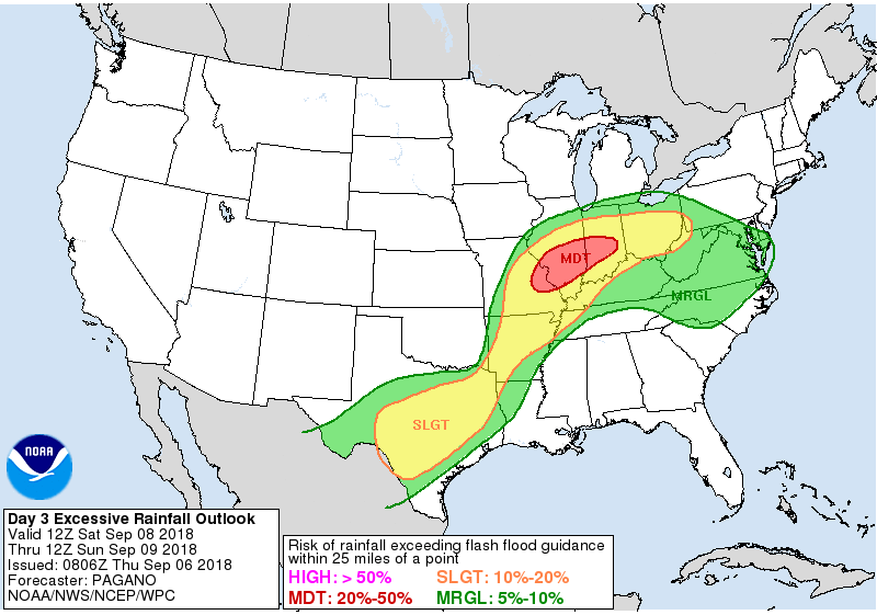
Here is the latest WPC/NOAA rainfall outlook.
Keep in mind, this graphic won’t capture those locally heavy thunderstorms that we often have during the summer months. Those storms can easily drop an inch or more of rain in less than an hour.
Here is the 72-hour rainfall forecast.
You may need to enlarge these to read the numbers. Just click on each image.
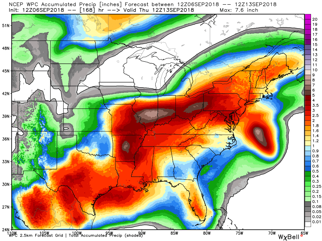
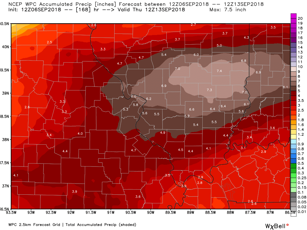
Here is the seven-day rainfall forecast. This takes us into next Thursday morning
Remember, this is never exact. Take the general idea of how much rain could fall. Some will receive more and some less, as always is the case in our region.
National view. You can see where the tropical system tracks. If the track of the tropical system shifts then this would need updating.
Most of this falls Thursday through Saturday night.
Click to enlarge
.
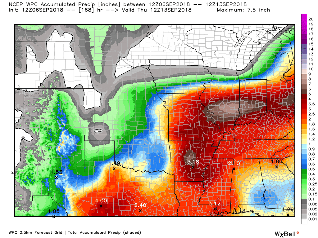
Here is the zoomed version of the above centered on southeast Missouri and southern Illinois
Notice the sharp gradient. This graphic takes us from now through 7 AM next Thursday
Click to enlarge the graphics.
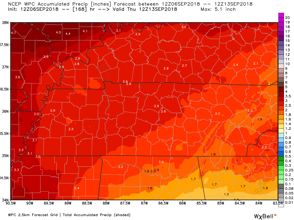
Zooming in on Kentucky and Tennessee.
This is through 7 AM next Thursday

We offer interactive local city live radars and regional radars.
If a radar does not update then try another one. If a radar does not appear to be refreshing then hit Ctrl F5 on your keyboard.
You may also try restarting your browser. The local city view radars also have clickable warnings.
During the winter months, you can track snow and ice by clicking the winterize button on the local city view interactive radars.

Questions? Broken links? Other questions?
You may email me at beaudodson@usawx.com

The National Weather Service defines a severe thunderstorm as one that produces quarter size hail or larger, 58 mph winds or greater, and/or a tornado.
Today through Tuesday: Severe weather is not anticipated. Showers and some thunderstorms will be possible over the coming days. There is a lot of moisture in the atmosphere. If thunderstorms form then they would produce heavy rain. Showers would also produce heavy rain.
There is a chance of flash flooding in a few localized areas. Monitor the latest watches and warnings (if any are issued).
At this time, the severe weather risk appears limited. I will be monitoring the coming days. Occasionally, these tropical systems produce tropical funnel clouds and even brief tornadoes.
The risk appears low.
Summer thunderstorms can produce isolated microbursts.
microburst winds can exceed 50 mph.
What are microbursts?

Interactive live weather radar page. Choose the city nearest your location. If one of the cities does not work then try a nearby one. Click here.
National map of weather watches and warnings. Click here.
Storm Prediction Center. Click here.
Weather Prediction Center. Click here.

Live lightning data: Click here.

Interactive GOES R satellite. Track clouds. Click here.

Here are the latest local river stage forecast numbers Click Here.
Here are the latest lake stage forecast numbers for Kentucky Lake and Lake Barkley Click Here.

- Heavy rain is a concern over the coming days.
- Cooler temperatures because of rain.
.
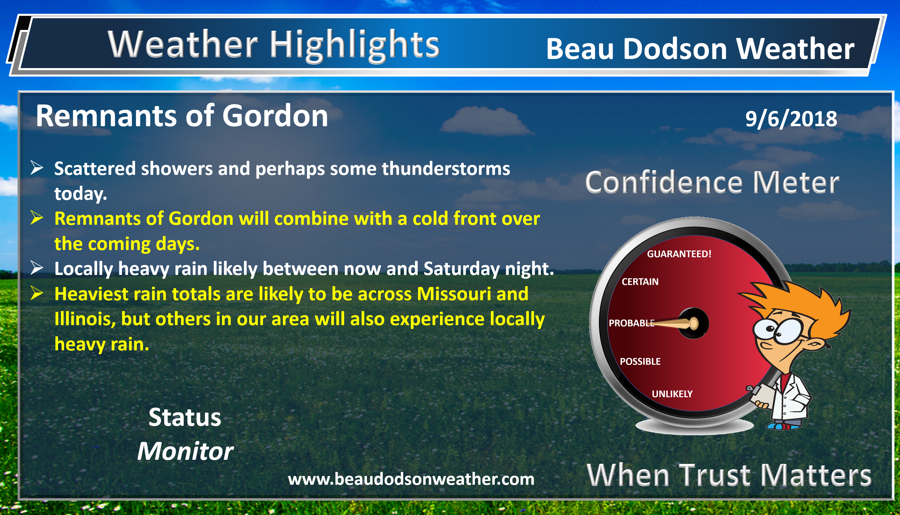
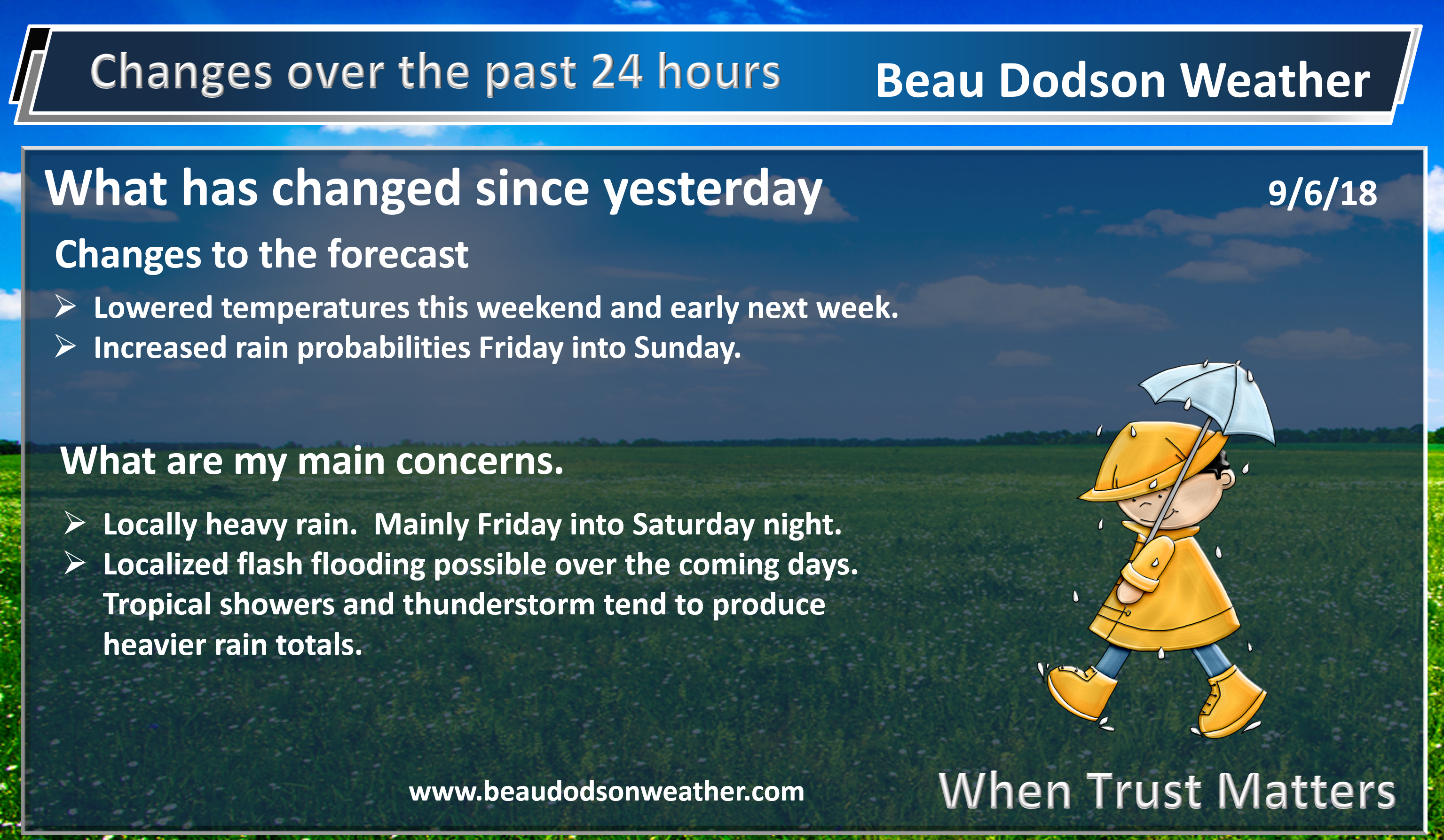
The main weather story continues to be the remnants of tropical storm Gordon. A cold front is pushing into the region from the north and northwest. This combination will be the trigger for showers and a few thunderstorms over the coming days.

Gordon’s outer bands brought some rain to the region yesterday. A band of showers and thunderstorms formed along an outflow boundary that moved into the area from the south.
We will have waves of showers and thunderstorms over the coming days.
Tropical systems tend to not produce much in the way of lightning. There will be some chance of lightning., but not as much as one would normally expect.
The bigger concern will be locally heavy rain.
You can see the rain charts above. They spell it out. Portions of southeast Missouri and southern Illinois will likely see 1.5 to 3.0″ of rain. Locally higher totals are certainly possible.
Elsewhere, rain totals will rain from one to two inches. As always, there will be those who pick up more rain and those who receive less. That is just the nature of the atmosphere.
If the system were to shift a bit further south then rain totals would be increased. The GFS model has been the furthest south. This will need to be monitored.
This is one of the better chances of rain in quite some time. Hopefully, many of you will receive some much-needed rainfall.
There could be gusty winds near the heavier showers and thunderstorms.
The risk of severe weather appears low, but I will be carefully monitoring it. Sometimes these tropical systems produce brief funnel clouds and even short-lived tornadoes.
At this time, the severe weather risk appears small.
We will have some showers and thunderstorms today. Locally heavy rain where they occur. Precipitation will be scattered today. Greater coverage over the coming days.
Here is the SPC WRF model guidance. This shows you what radar might look like today (it will not be exact). Just take the general idea of this graphic. Some showers and thunderstorms are possible today.
Time-stamp upper left.
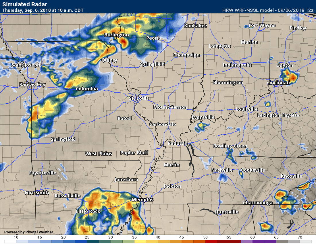
Most of the rain will fall Friday afternoon into Saturday night. That certainly is not to say there won’t be rain on the radar today. There will be. The rain coverage, however, should increase Friday into Saturday.
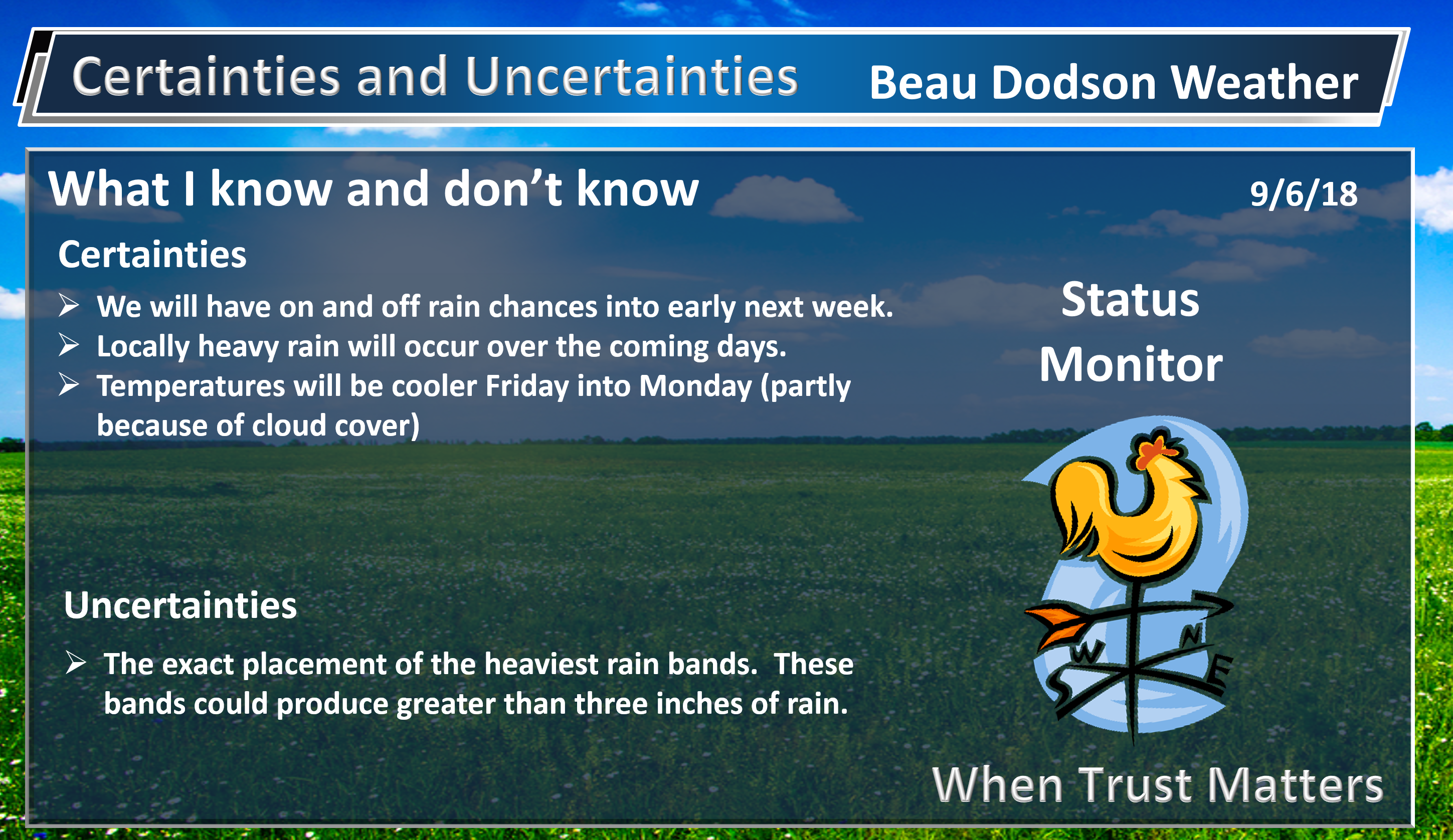
Sunday into Tuesday will deliver some clouds and spotty showers, as well. Perhaps the greatest coverage between those days would be Sunday. Locally heavy rain is still a concern Sunday. This is especially true south of the cold front. That would likely be the Missouri Bootheel, southeast Illinois, western Kentucky, and northwest Tennessee.
Temperatures will be considerably cooler with the clouds and rains. As a matter of fact, you will notice in the daily forecast that I have 70’s for daytime highs and even some upper 50’s for overnight lows. We will take that! It might actually feel a little bit like fall.
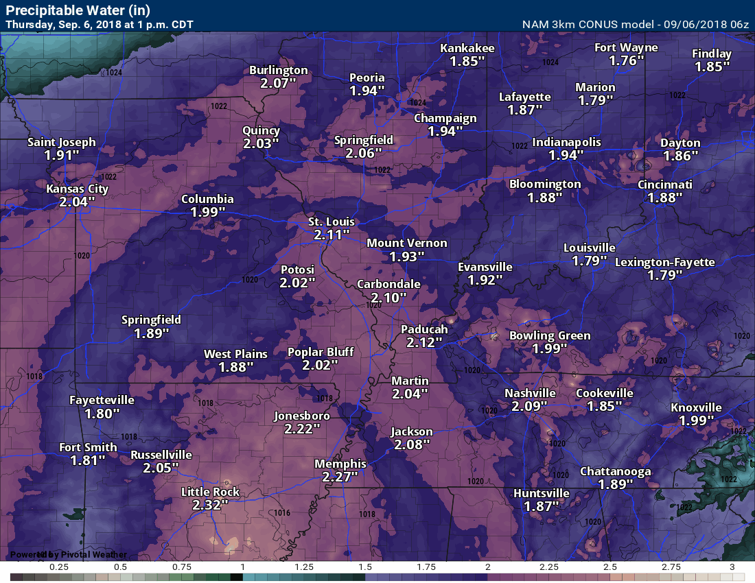
PWAT’s are a measure of moisture in the entire atmosphere. We will have very high PWAT values with this incoming system. Why? The moisture is coming out of the Atlantic Ocean and the Gulf of Mexico. These tropical systems carry copious amounts of moisture. The equals high PWAT values.
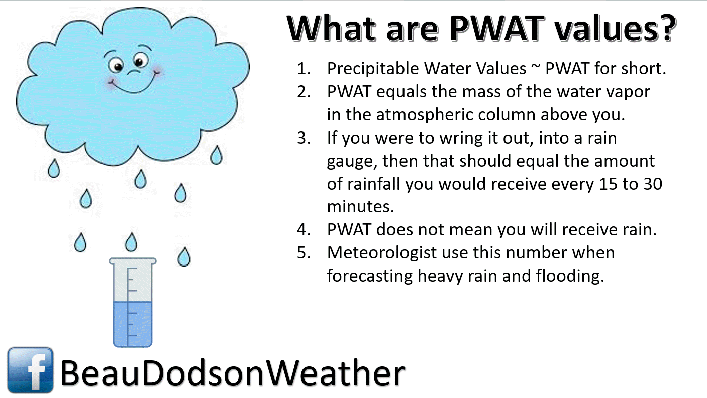
Check out this animation of PWAT values. Anything about 1.7″ is high. Above 2″ is extreme.
The bottom line is that showers and thunderstorms will be prolific rain producers. A lot of moisture to tap into.
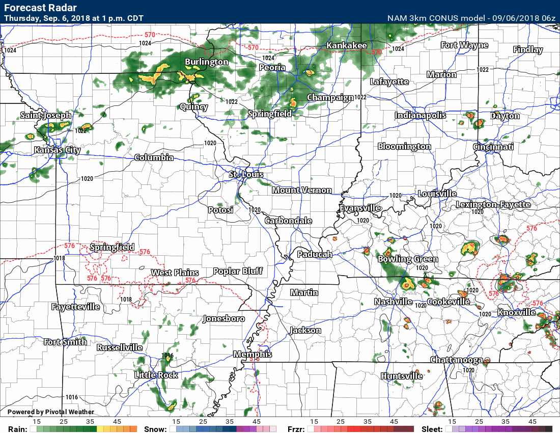
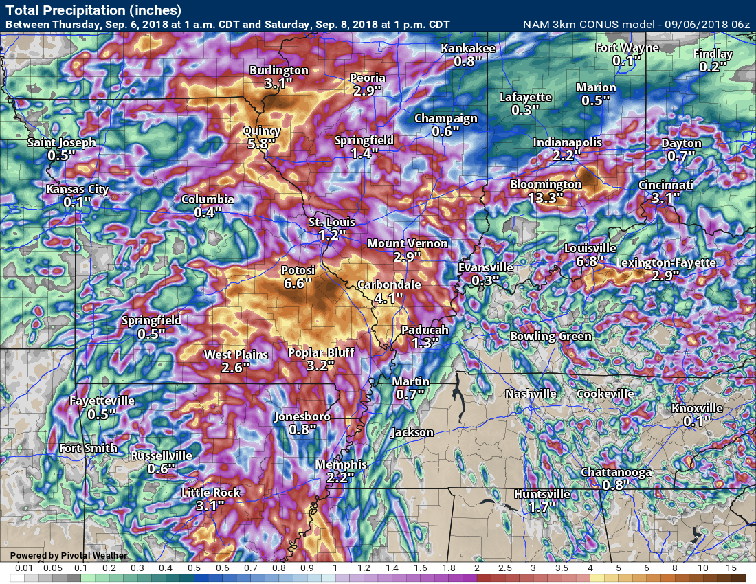
Here is the NAM 3K model future-cast radar through Saturday morning.
Click to enlarge.
This won’t be exact, of course. This is simply a model’s projection of what radar might look like. Green is rain. Yellow and orange would be heavier rain.
The WPC/NOAA has placed our region a risk of flash flooding over the coming days.
A marginal to slight risk today. A slight risk Friday and Saturday. The moderate a risk will clip our northern counties.
What does this mean? It just means that there is the potential of locally heavy rain that could cause pockets of flash flooding.
Note: There could still be shifts in this forecast. If the heavier rain ends up being further south then a larger portion of our region would be placed in the slight to moderate risk zone.
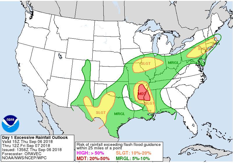
Tomorrow
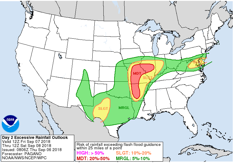
Saturday
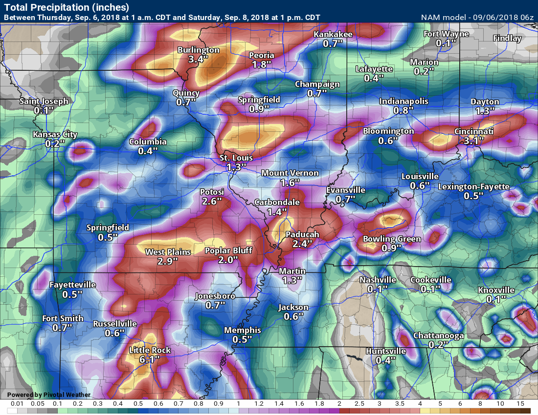
Let’s take a look at some model rainfall totals.
I will be closely monitoring radar and satellite trends over the next few days. There could still be some shift in where the heaviest rain totals are placed.
Some of the models below show extremely heavy rain.
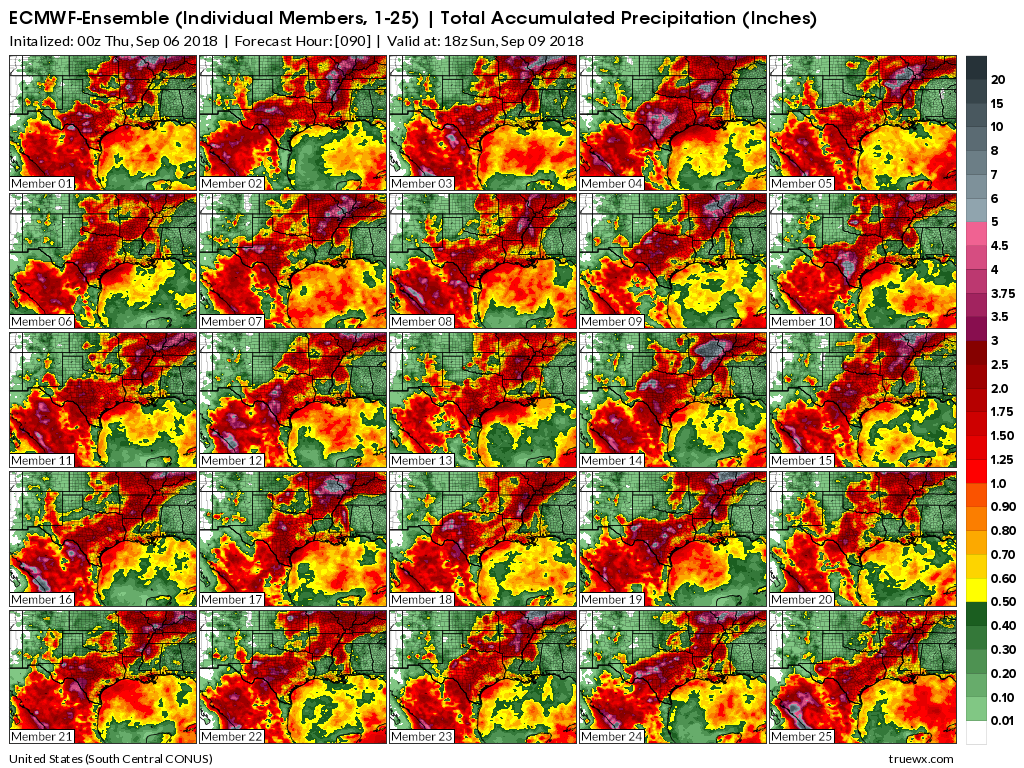
The ensembles do not support the large numbers you see below (on some of the individual model run graphics).
The ensembles keep the heaviest rain to our north.
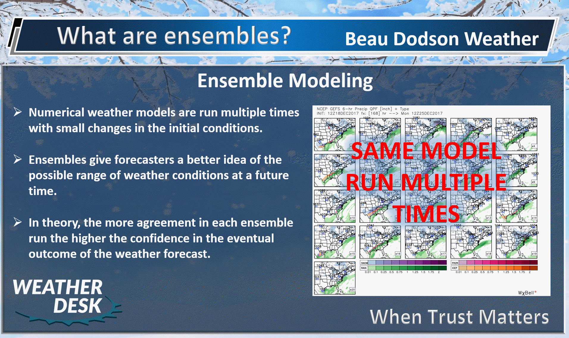
What are the ensembles?
The GFS model guidance ensembles show the heaviest rain to our north (the grey area). Click image to enlarge.

Another model, the EC, ensembles do show the heavier rain a bit further south.
This will need to be monitored.
EC ensembles. Again, the grey area is the heaviest rain.
These are forecasted rain totals through 1 PM Saturday.
These models have had wild swings over the last few days. Some showing three to six inches of rain locally. Then another run of the same model cuts that in half.
The bottom line is that we will have shower and thunderstorm chances into at least Sunday night and perhaps a bit longer. Some of the rain could be heavy.
This is the high-resolution NAM 3K model.
Here is the lower resolution NAM model.
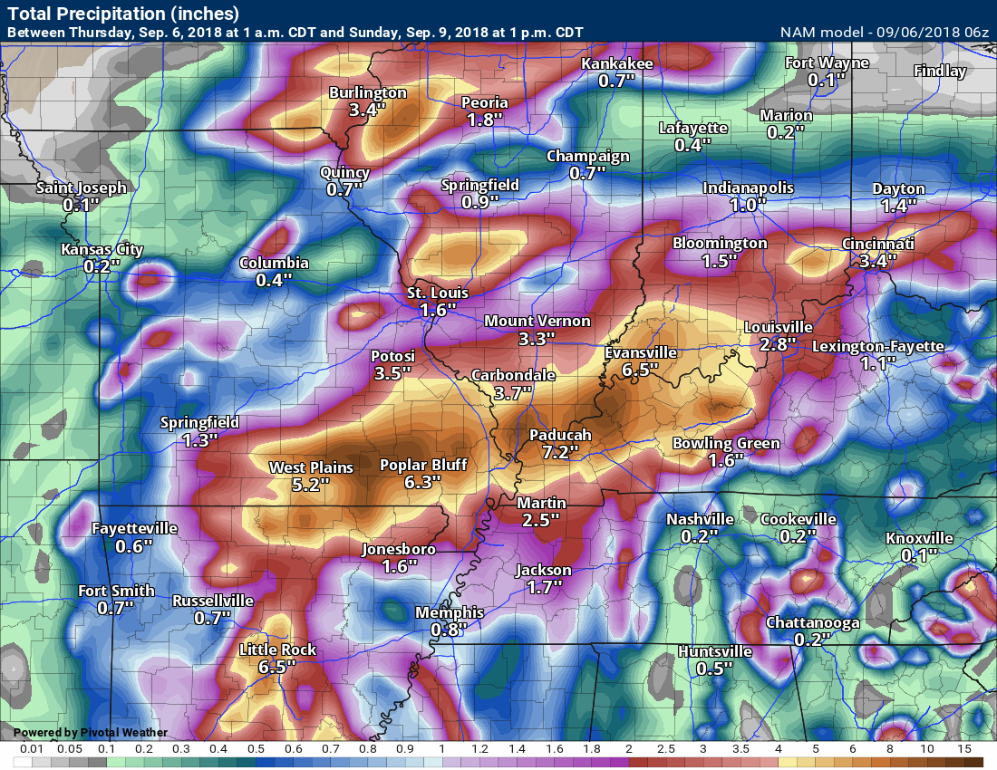
Now let’s look at the NAM model through 1 PM Sunday.
Some of these models go all out in the rain department.
There is certainly lower confidence in rain totals above the two or three-inch mark. If the system does shift south a tad then heavier totals are possible.
Let’s keep a close eye on it.
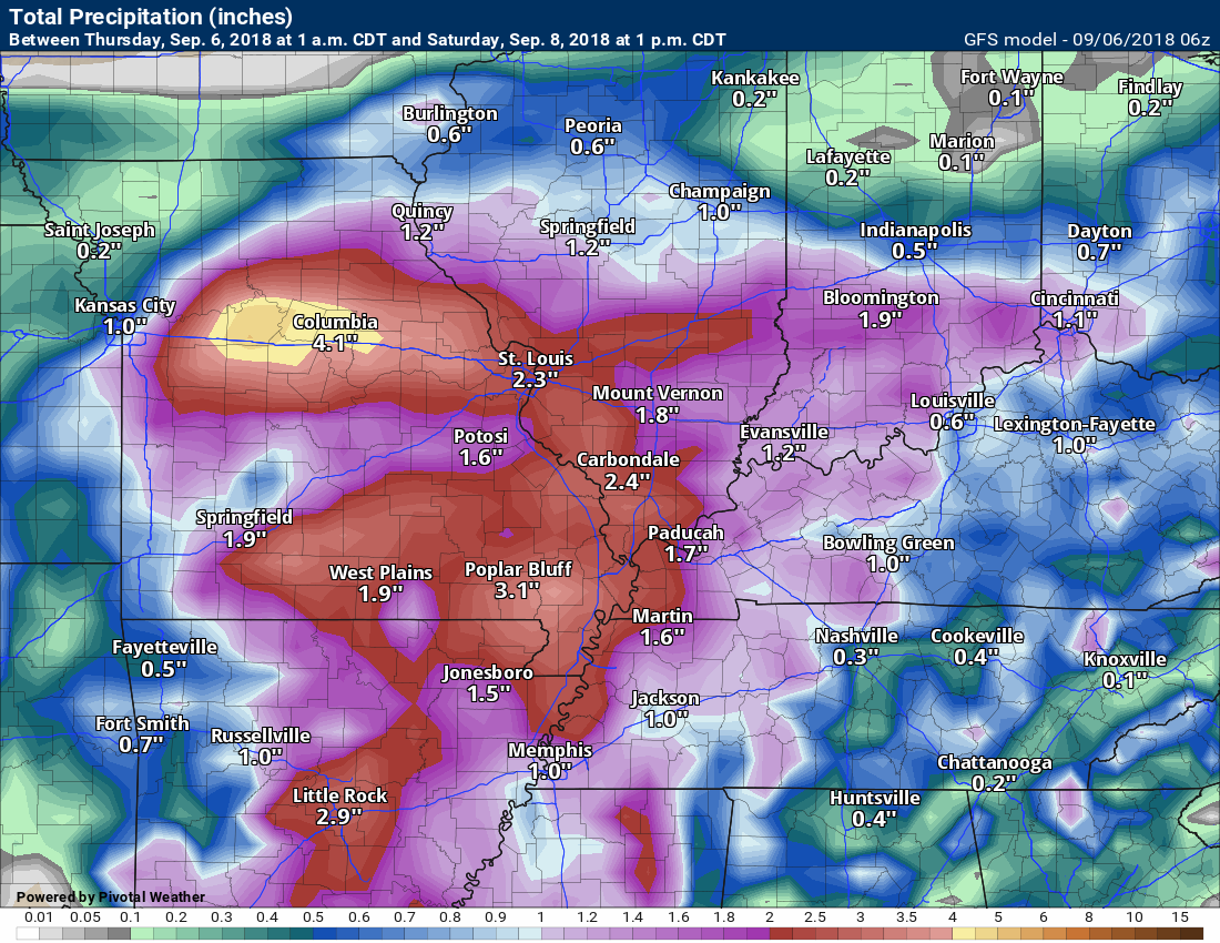
Here are the GFS model guidance rainfall totals through 1 PM Saturday. Again, just another model.
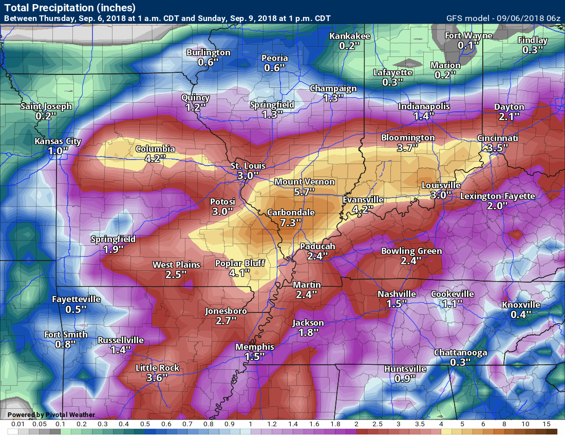
Now, let’s look at rain totals from the GFS model through 1 PM Sunday.
Some of these models go all out in the rain department.
There is certainly lower confidence in rain totals above the two or three-inch mark. If the system does shift south a tad then heavier totals are possible.
Let’s keep a close eye on it.
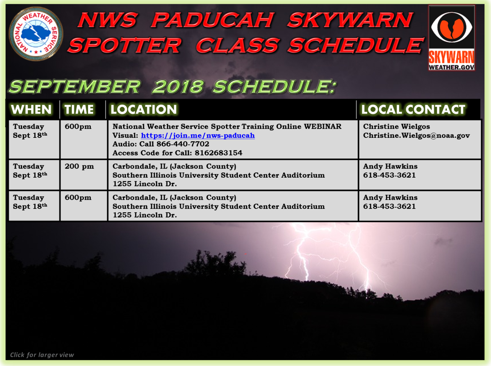
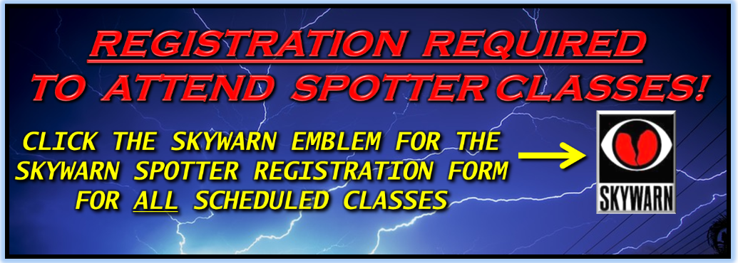
Spotter classes
![]()
Here is the preliminary fall outlook from the long range meteorology team.
Click to enlarge this graphic.
.
![]()
The September forecast has been updated.
![]()

I bring these to you from the BAMwx team. They are excellent long-range forecasters.
Remember, long-range outlooks are a bit of skill, understanding weather patterns, and luck combined. It is not an exact science.

This product is for subscribers.
Subscribe at www.weathertalk.com
Subscriber graphics can be viewed on this page CLICK HERE

This product is for subscribers.

Subscriber graphics can be viewed on this page CLICK HERE
![]()
.
First glance at fall!
Preliminary October precipitation outlook
Here is the preliminary November temperature and precipitation outlook
Preliminary November temperature outlook
Preliminary November precipitation outlook
.
![]()

![]()

A new weather podcast is now available! Weather Geeks (which you might remember is on The Weather Channel each Sunday)
To learn more visit their website. Click here.
![]()

WeatherBrains Episode 659
Dr. Jack Davis, our Guest WeatherBrain for this episode of our netcast, is the professor of history at the University of Florida and a Pulitzer Prize-winning author of the book The Gulf: The Making of an American Sea. His areas of specialization include US Environmental History, Modern US, US South, Florida History, and Sustainability Studies. He has penned two other books: An Everglades Providence: Marjory Stoneman Douglas and the American Environmental Century and Race Against Time: Culture and Separation in Natchez Since 1930.
Other discussions in this weekly podcast include topics like:
- Extremes: 113 at Death Valley, CA, and 24 at Stanley, ID
- Hurricane Gordon making landfall in north central Gulf Coast
- Typhoon Jebi smashes Japan
- Excessive rain along front from Colorado to western Great Lakes
- Astronomy Outlook with Tony Rice
- and more!
Link to web-site https://weatherbrains.com/
Previous episodes can be viewed by clicking here.

We offer interactive local city live radars and regional radars. If a radar does not update then try another one. If a radar does not appear to be refreshing then hit Ctrl F5. You may also try restarting your browser.
The local city view radars also have clickable warnings.
During the winter months, you can track snow and ice by clicking the winterize button on the local city view interactive radars.
You may email me at beaudodson@usawx.com
Find me on Facebook!

Find me on Twitter!

Did you know that a portion of your monthly subscription helps support local charity projects?
You can learn more about those projects by visiting the Shadow Angel Foundation website and the Beau Dodson News website.

I encourage subscribers to use the app vs regular text messaging. We have found text messaging to be delayed during severe weather. The app typically will receive the messages instantly. I recommend people have three to four methods of receiving their severe weather information.
Remember, my app and text alerts are hand typed and not computer generated. You are being given personal attention during significant weather events.
