WeatherTalk monthly operating costs can top $2000.00. Your $5 subscription helps pay for those costs. I work for you.
The $5 will allow you to register up to seven phones!
For $5 a month you can receive the following. You may choose to receive these via your WeatherTalk app or regular text messaging.
Severe weather app/text alerts from my keyboard to your app/cell phone. These are hand typed messages from me to you. During tornado outbreaks, you will receive numerous app/text messages telling you exactly where the tornado is located.
- Daily forecast app/texts from my computer to your app/cell phone.
- Social media links sent directly to your app/cell phone. When I update the blog, videos, or Facebook you will receive the link.
- AWARE emails. These emails keep you well ahead of the storm. They give you several days of lead time before significant weather events.
- Direct access to Beau via text and email. Your very own personal meteorologist. I work for you!
- Missouri and Ohio Valley centered video updates
- Long-range weather videos
- Week one, two, three and four temperature and precipitation outlooks.
Monthly outlooks. - Your subscription also will help support several local charities.
Would you like to subscribe? Subscribe at www.beaudodsonweather.com

I encourage subscribers to use the app vs regular text messaging. We have found text messaging to be delayed during severe weather. The app typically will receive the messages instantly. I recommend people have three to four methods of receiving their severe weather information.
Remember, my app and text alerts are hand typed and not computer generated. You are being given my personal attention during significant weather events.

WWW.WEATHERTALK.COM subscribers, here is my day to day schedule for your weather products.
These are bonus videos and maps for subscribers. I bring these to you from the BAMwx team. I pay them to help with videos.
The Ohio and Missouri Valley videos cover most of our area. They do not have a specific Tennessee Valley forecast but may add one in the future.
The long-range video is technical. Over time, you can learn a lot about meteorology from the long range video. Just keep in mind, it is a bit more technical.


Subscriber graphics can be viewed on this page CLICK HERE
![]()

Here is the preliminary winter temperature outlook from the long-range meteorology team.
Subscriber graphics can be viewed on this page CLICK HERE

October 05, 2018
Friday Forecast Details
Forecast: Mostly sunny. Hot and humid. Near record high temperatures. An isolated thunderstorm possible. The majority of the region will remain dry.
Temperatures: MO ~ 86 to 90 IL ~ 86 to 90 KY ~ 86 to 92 TN ~86 to 92
What is the chance of precipitation? MO ~ 30% IL ~ 30% KY ~ 20% TN ~ 20%
Coverage of precipitation: Isolated to widely scattered
Wind: South at 8 to 16 mph with higher gusts possible, especially over southeast Missouri and southern Illinois.
What impacts are anticipated from the weather? Isolated to widely scattered wet roads and lightning
My confidence in the forecast verifying: High
Is severe weather expected? No
The NWS defines severe weather as 58 mph wind or great, 1″ hail or larger, and/or tornadoes
Should I cancel my outdoor plans? No, but check radars
UV Index: 8 High
Sunrise: 6:54 AM
Friday Night Forecast Details:
Forecast: Mostly clear to partly cloudy. Warm and humid. Near record high low temperatures. Patchy fog possible.
Temperatures: MO ~ 68 to 72 IL ~ 68 to 72 KY ~ 68 to 72 TN ~ 68 to 72
What is the chance of precipitation? MO ~ 10% IL ~ 10% KY ~ <10% TN ~ <10%
Coverage of precipitation: An isolated evening storm over southeast Missouri and southern Illinois. Low chances.
Wind: South at 6 to 12 mph
What impacts are anticipated from the weather? Lower visibility if fog forms
My confidence in the forecast verifying: High
Is severe weather expected? No
The NWS defines severe weather as 58 mph wind or great, 1″ hail or larger, and/or tornadoes
Should I cancel my outdoor plans? No, but check the radars
Sunset: 6:33 PM
Moonrise: 4:48 PM Waning Crescent
Moonset: 2:43 AM
October 06, 2018
Saturday Forecast Details
Forecast: Partly to mostly sunny. Hot and humid. Well above normal temperatures. A slight chance of an isolated thunderstorm near Poplar Bluff to Perryville, Missouri. Otherwise, thunderstorm chances elsewhere will be at or less than ten percent.
Temperatures: MO ~86 to 92 IL ~ 86 to 92 KY ~ 86 to 92 TN ~ 86 to 92
What is the chance of precipitation? MO ~ 20% IL ~ 10% KY ~ 0% TN ~ 0%
Coverage of precipitation: None to isolated
Wind: South at 7 to 14 mph with higher gusts possible
What impacts are anticipated from the weather? Most likely none. A low-end thunderstorm chance over southeast Missouri. Lightning would be the concern if a storm forms. Most of the region will remain dry.
My confidence in the forecast verifying: High
Is severe weather expected? No
The NWS defines severe weather as 58 mph wind or great, 1″ hail or larger, and/or tornadoes
Should I cancel my outdoor plans? No. Perhaps glance at radars in southeast Missouri.
UV Index: 8 High
Sunrise: 6:55 AM
Saturday Night Forecast Details:
Forecast: A few clouds, otherwise mostly clear. Warm. Humid. Well above normal temperatures. Patchy fog.
Temperatures: MO ~ 65 to 70 IL ~ 65 to 70 KY ~ 65 to 70 TN ~ 65 to 70
What is the chance of precipitation? MO ~ 10% IL ~ 10% KY ~ 0% TN ~ 0%
Coverage of precipitation: Most likely none.
Wind: South and southeast at 6 to 12 mph
What impacts are anticipated from the weather? Most likely none.
My confidence in the forecast verifying: High
Is severe weather expected? No
The NWS defines severe weather as 58 mph wind or great, 1″ hail or larger, and/or tornadoes
Should I cancel my outdoor plans? No
Sunset: 6:31 PM
Moonrise: 3:53 AM Waning Crescent
Moonset: 5:27 PM
October 07, 2018
Sunday Forecast Details
Forecast: Partly to mostly sunny. I will be monitoring thunderstorm chances. For the time being, I kept thunderstorm chances low. Hot and humid. Well above normal temperatures.
Temperatures: MO ~ 86 to 92 IL ~ 86 to 92 KY ~ 86 to 92 TN ~ 86 to 92
What is the chance of precipitation? MO ~ 20% IL ~ 20% KY ~ 0% TN ~ 0%
Coverage of precipitation: None to isolated
Wind: South and southeast winds at 7 to 14 mph with gusts to 18 mph
What impacts are anticipated from the weather? Isolated lightning.
My confidence in the forecast verifying: Medium
Is severe weather expected? Unlikely
The NWS defines severe weather as 58 mph wind or great, 1″ hail or larger, and/or tornadoes
Should I cancel my outdoor plans? No, but monitor updates
UV Index: 8 High
Sunrise: 6:56 AM
Sunday Night Forecast Details:
Forecast: Mostly clear to partly cloudy. Mild temperatures. Patchy fog.
Temperatures: MO ~ 66 to 70 IL ~ 66 to 70 KY ~ 66 to 70 TN ~ 66 to 70
What is the chance of precipitation? MO ~ 20% IL ~ 20% KY ~ 0% TN ~ 0%
Coverage of precipitation: None to isolated
Wind: Southeast at 6 to 12 mph
What impacts are anticipated from the weather? Some patchy fog could lower visibility.
My confidence in the forecast verifying: Medium
Is severe weather expected? Unlikely
The NWS defines severe weather as 58 mph wind or great, 1″ hail or larger, and/or tornadoes
Should I cancel my outdoor plans? No
Sunset: 6:30 PM
Moonrise: 5:03 AM Waning Crescent
Moonset: 6:04 PM
October 08, 2018
Monday forecast: Mostly sunny to partly cloudy. Warm and humid. Well above normal temperatures.
Temperatures: MO ~ 84 to 88 IL ~ 84 to 88 KY ~ 84 to 88 TN ~ 84 to 88
What is the chance of precipitation? MO ~ 20% IL ~ 10% KY ~ 0% TN ~ 0%
Coverage of precipitation: Mostly likely none.
Wind: South and southeast at 6 to 12 mph
What impacts are anticipated from the weather? Most likely none.
My confidence in the forecast verifying: Medium
Is severe weather expected? Unlikely
The NWS defines severe weather as 58 mph wind or great, 1″ hail or larger, and/or tornadoes
Should I cancel my outdoor plans? No
UV Index: 8 High
Sunrise: 6:57 AM
Monday Night Forecast Details:
Forecast: Mostly clear to partly cloudy. Patchy fog again possible.
Temperatures: MO ~ 65 to 70 IL ~ 65 to 70 KY ~ 65 to 70 TN ~ 65 to 70
What is the chance of precipitation? MO ~ 10% IL ~ 10% KY ~ 0% TN ~ 0%
Coverage of precipitation: Most likely none
Wind: Southeast winds at 6 to 12 mph
What impacts are anticipated from the weather? Most likely none. If fog forms, then lower visibility will occur.
My confidence in the forecast verifying: Medium
Is severe weather expected? No
The NWS defines severe weather as 58 mph wind or great, 1″ hail or larger, and/or tornadoes
Should I cancel my outdoor plans? No
Sunset: 6:28 PM
Moonrise: 6:12 AM Waning Crescent
Moonset: 6:38 PM
October 09, 2018
Tuesday forecast: Mostly sunny during the morning. Increasing clouds through the day. A chance of a shower or thunderstorm over southeast Missouri and southern Illinois.
Temperatures: MO ~ 84 to 86 IL ~ 84 to 86 KY ~ 84 to 88 TN ~ 84 to 88
What is the chance of precipitation? MO ~ 40% IL ~ 30% KY ~ 20% TN ~ 20%
Coverage of precipitation: Scattered. Precipitation should increase during the PM hours.
Wind: South and southeast at 8 to 16 mph
What impacts are anticipated from the weather? Wet roadways. Lightning.
My confidence in the forecast verifying: Medium
Is severe weather expected? Monitor updates
The NWS defines severe weather as 58 mph wind or great, 1″ hail or larger, and/or tornadoes
Should I cancel my outdoor plans? I would monitor updates.
UV Index: 6 to 8 High (if clouds are thicker, then this number will be lowered)
Sunrise: 6:58 AM
Tuesday Night Forecast Details:
Forecast: Mostly cloudy with showers and thunderstorms.
Temperatures: MO ~ 64 to 68 IL ~ 64 to 68 KY ~ 64 to 68 TN ~ 64 to 68
What is the chance of precipitation? MO ~ 50% IL ~ 50% KY ~ 40% TN ~ 40%
Coverage of precipitation: Scattered to perhaps numerous
Wind: Southeast winds at 6 to 12 mph
What impacts are anticipated from the weather? Wet roadways and lightning.
My confidence in the forecast verifying: Medium
Is severe weather expected? Monitor updates
The NWS defines severe weather as 58 mph wind or great, 1″ hail or larger, and/or tornadoes
Should I cancel my outdoor plans? Monitor radars and forecast updates. Rain is possible.
Sunset: 6:27 PM
Moonrise: 7:18 AM New Moon
Moonset: 7:12 PM
October 10, 2018
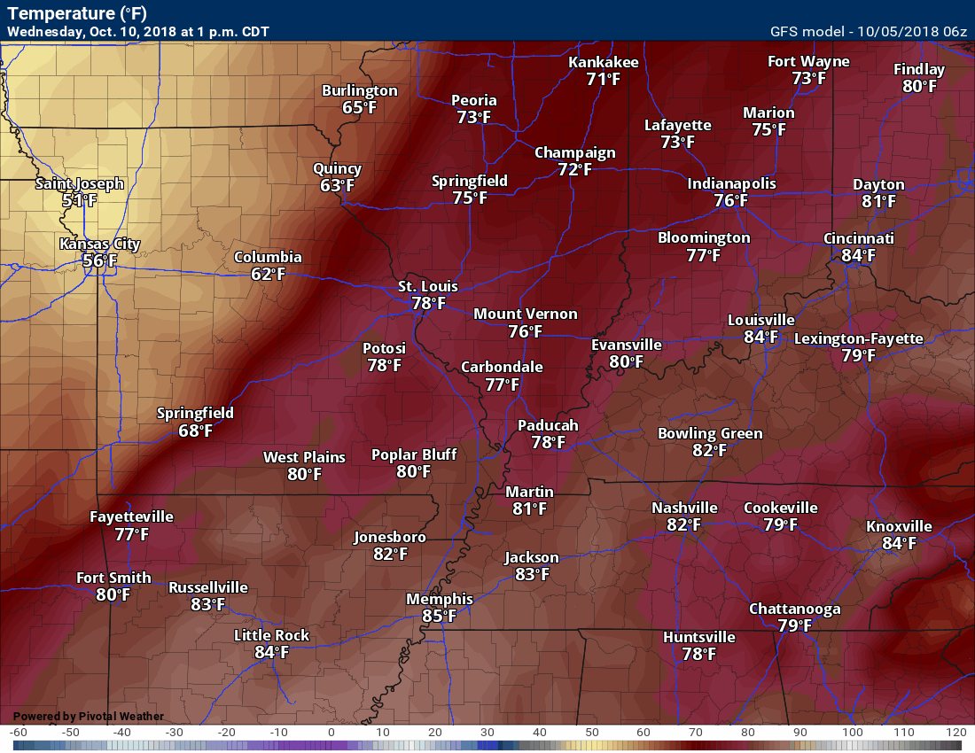
Wednesday forecast: Cloudy with showers and thunderstorms likely.
Temperatures: MO ~ 76 to 82 IL ~ 76 to 82 KY ~ 76 to 82 TN ~ 76 to 82
What is the chance of precipitation? MO ~ 60% IL ~ 60% KY ~ 60% TN ~ 60%
Coverage of precipitation: Perhaps numerous
Wind: South at 8 to 16 mph
What impacts are anticipated from the weather? Wet roadways. Lightning.
My confidence in the forecast verifying: Medium
Is severe weather expected? Monitor updates
The NWS defines severe weather as 58 mph wind or great, 1″ hail or larger, and/or tornadoes
Should I cancel my outdoor plans? Have a plan B
UV Index: 2 to 4 low
Sunrise: 6:59 AM
Wednesday Night Forecast Details:
Forecast: Mostly cloudy with showers and thunderstorms.
Temperatures: MO ~ 56 to 62 IL ~ 56 to 62 KY ~ 56 to 62 TN ~ 56 to 62
What is the chance of precipitation? MO ~ 60% IL ~ 60% KY ~ 60% TN ~ 60%
Coverage of precipitation: Perhaps numerous
Wind: Southwest becoming west/northwest at 8 to 16 mph
What impacts are anticipated from the weather? Wet roadways and lightning.
My confidence in the forecast verifying: Medium
Is severe weather expected? Monitor updates
The NWS defines severe weather as 58 mph wind or great, 1″ hail or larger, and/or tornadoes
Should I cancel my outdoor plans? Have a plan B
Sunset: 6:25 PM
Moonrise: 8:25 AM New Moon
Moonset: 7:46 PM
October 11, 2018
Thursday forecast: Partly cloudy and cooler.
Temperatures: MO ~ 74 to 78 IL ~ 74 to 78 KY ~ 74 to 78 TN ~ 74 to 78
What is the chance of precipitation? MO ~ 0% IL ~ 0% KY ~ 0% TN ~ 0%
Coverage of precipitation: Most likely none
Wind: North and northwest at 6 to 12 mph
What impacts are anticipated from the weather? Most likely none
My confidence in the forecast verifying: Medium
Is severe weather expected? No
The NWS defines severe weather as 58 mph wind or great, 1″ hail or larger, and/or tornadoes
Should I cancel my outdoor plans? No
UV Index: 6 high
Sunrise: 7:00 AM
Wednesday Night Forecast Details:
Forecast: Mostly clear. Patchy fog possible.
Temperatures: MO ~ 48 to 54 IL ~ 48 to 54 KY ~ 48 to 54 TN ~ 48 to 54
What is the chance of precipitation? MO ~ 0% IL ~ 0% KY ~ 0% TN ~ 0%
Coverage of precipitation: None
Wind: North at 6 to 12 mph
What impacts are anticipated from the weather? Lower visibility if fog forms.
My confidence in the forecast verifying: Medium
Is severe weather expected? No
The NWS defines severe weather as 58 mph wind or great, 1″ hail or larger, and/or tornadoes
Should I cancel my outdoor plans? No
Sunset: 6:24 PM
Moonrise: 9:29 AM Waxing Crescent
Moonset: 8:23 PM
October 12, 2018
Friday forecast: Increasing clouds.
Temperatures: MO ~ 64 to 68 IL ~ 64 to 68 KY ~ 64 to 68 TN ~ 64 to 68
What is the chance of precipitation? MO ~ 20% IL ~ 10% KY ~ 0% TN ~ 0%
Coverage of precipitation: None to isolated
Wind: North and northwest at 6 to 12 mph
What impacts are anticipated from the weather? None to wet roadways.
My confidence in the forecast verifying: LOW
Is severe weather expected? No
The NWS defines severe weather as 58 mph wind or great, 1″ hail or larger, and/or tornadoes
Should I cancel my outdoor plans? Monitor updates
UV Index: 5 moderate
Sunrise: 7:00 AM
Friday Night Forecast Details:
Forecast: Mostly cloudy. Rain showers possible.
Temperatures: MO ~ 48 to 52 IL ~ 48 to 52 KY ~ 48 to 54 TN ~ 48 to 54
What is the chance of precipitation? MO ~ 30% IL ~ 30% KY ~ 30% TN ~ 30%
Coverage of precipitation:
Wind:
What impacts are anticipated from the weather? Wet roadways
My confidence in the forecast verifying: LOW
Is severe weather expected? No
The NWS defines severe weather as 58 mph wind or great, 1″ hail or larger, and/or tornadoes
Should I cancel my outdoor plans? Monitor updates
Sunset: 6:22 PM
Moonrise: 10:31 AM Waxing Crescent
Moonset: 9:02 PM
Learn more about the UV index readings. Click here.

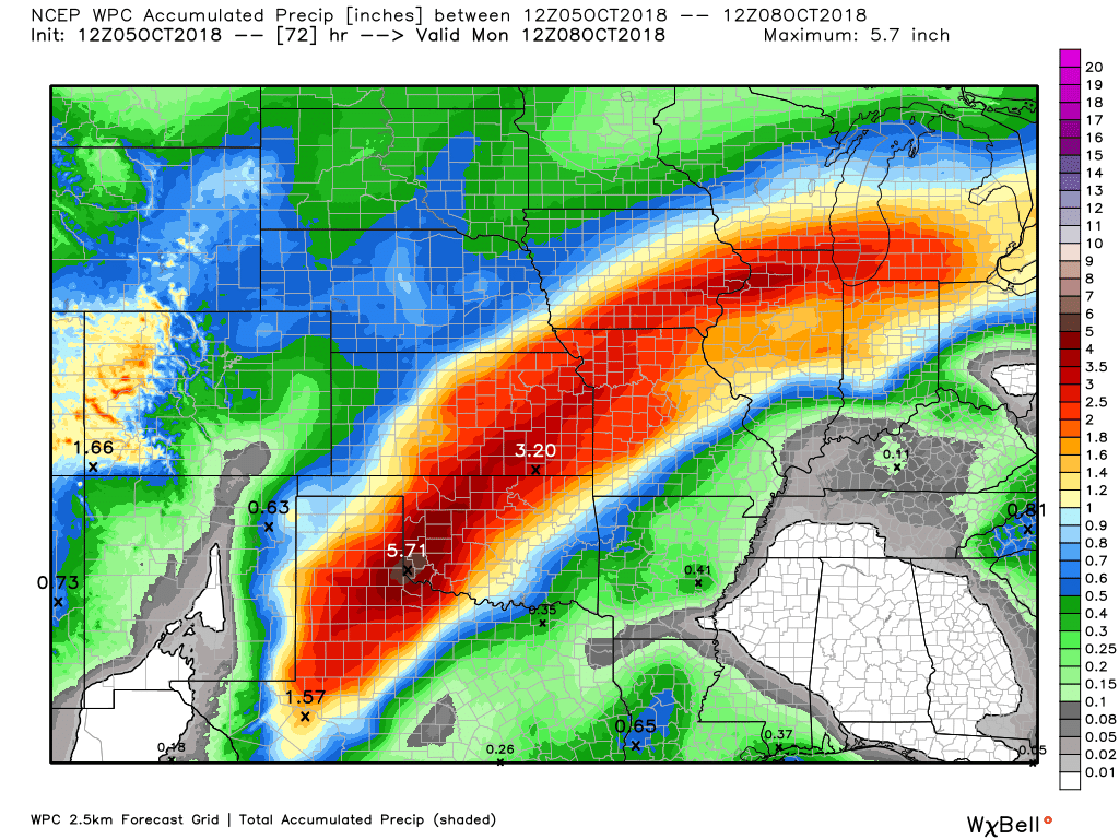
Here is the latest WPC/NOAA rainfall outlook.
This first image takes us through 7 AM Monday. Notice that most of the rain is to our west. Very heavy rain in the Central United States. Flooding likely in some areas.
A few showers and thunderstorms are possible locally, but most of our activity will take place next week.
Don’t expect much today through Sunday.
Click images to enlarge them.
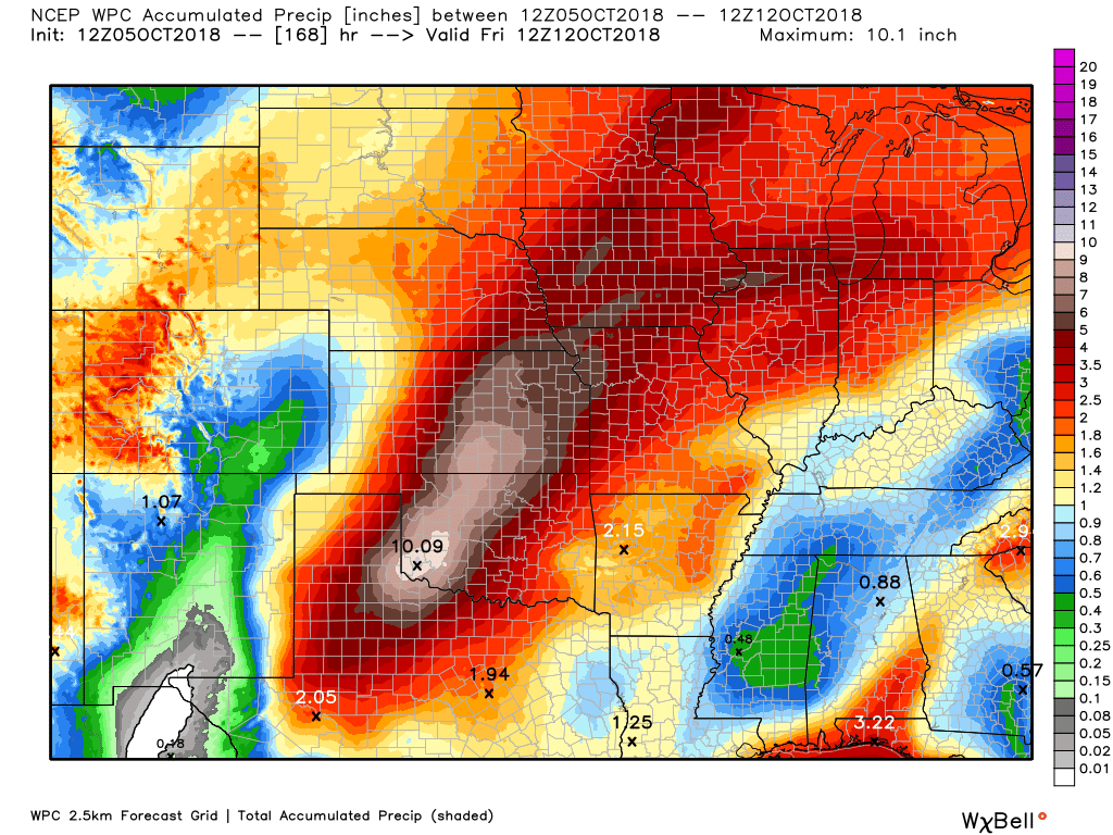
Here are the seven-day rainfall totals forecast from the WPC.
You can see the rain moves into our region next week.
Look at some of those amazing totals to our west. Portions of Oklahoma and Kansas could end up with more than ten inches of rain.
Click to enlarge the image. The scale is on the right side of the image.
Most of our rain will occur Tuesday/Wednesday. The timing will need to be ironed out.
Only low end thunderstorm chances over the coming days. Vast majority of the region will remain dry.
I would not change any weekend plans. Monitor radars if you see cumulus clouds building, otherwise, enjoy the summer weather.
Did you know that you can find me on Twitter?

Need a forecast for an outdoor event?


We offer interactive local city live radars and regional radars.
If a radar does not update then try another one. If a radar does not appear to be refreshing then hit Ctrl F5 on your keyboard.
You may also try restarting your browser. The local city view radars also have clickable warnings.
During the winter months, you can track snow and ice by clicking the winterize button on the local city view interactive radars.

Questions? Broken links? Other questions?
You may email me at beaudodson@usawx.com

The National Weather Service defines a severe thunderstorm as one that produces quarter size hail or larger, 58 mph winds or greater, and/or a tornado.
Today through Monday: Severe weather is not anticipated. An isolated thunderstorm is possible today through Sunday. I would not change any outdoor plans. The vast majority of the region will remain dry. Lightning would be the concern, if a thunderstorm develops during the heat of the day.
Shower and thunderstorm activity will increase Tuesday and Wednesday. This will be in response to an incoming cold front. Some thunderstorms are likely along the front. At this time, the threat of severe weather appears low, but perhaps not zero. Monitor updates.
Interactive live weather radar page. Choose the city nearest your location. If one of the cities does not work then try a nearby one. Click here.
National map of weather watches and warnings. Click here.
Storm Prediction Center. Click here.
Weather Prediction Center. Click here.

Live lightning data: Click here.

Interactive GOES R satellite. Track clouds. Click here.

Here are the latest local river stage forecast numbers Click Here.
Here are the latest lake stage forecast numbers for Kentucky Lake and Lake Barkley Click Here.

-
- Yesterdays rain
- Hot and humid (summer-like) weather
- WELL above normal temperatures
- A cold front arrives Tuesday/Wednesday
- Cooler temperatures are on the way
Yesterday’s rain
Rain coverage was not as great as anticipated Thursday. The reason for this is that the cold front never made it all the way into our region.
I had forecasted the front to push into Cape Girardeau County eastward to Pope County. Along and north of there is where the rain should have been.
There was rain, but totals were 0.05″ to 0.30″
Today through Monday night
Hot and humid weather is anticipated today through at least Monday.
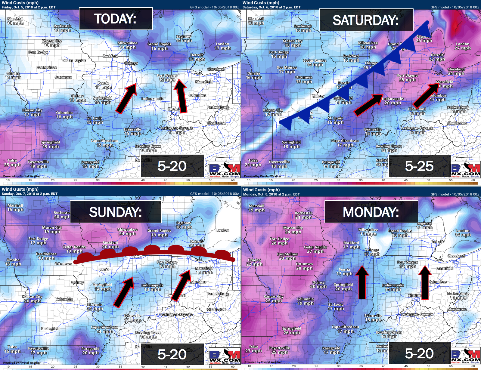
From time to time, we will have some gusty winds. Here is the wind forecast.
Click images on this page to enlarge them.
Daily high temperatures will range from 85 to 90 degrees (a few stations higher than that). Overnight lows will range from 66 to 74.
These temperatures will approach records.
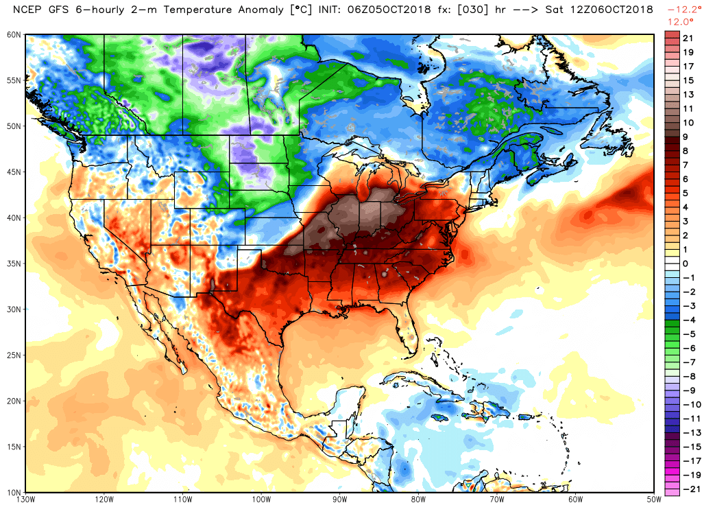
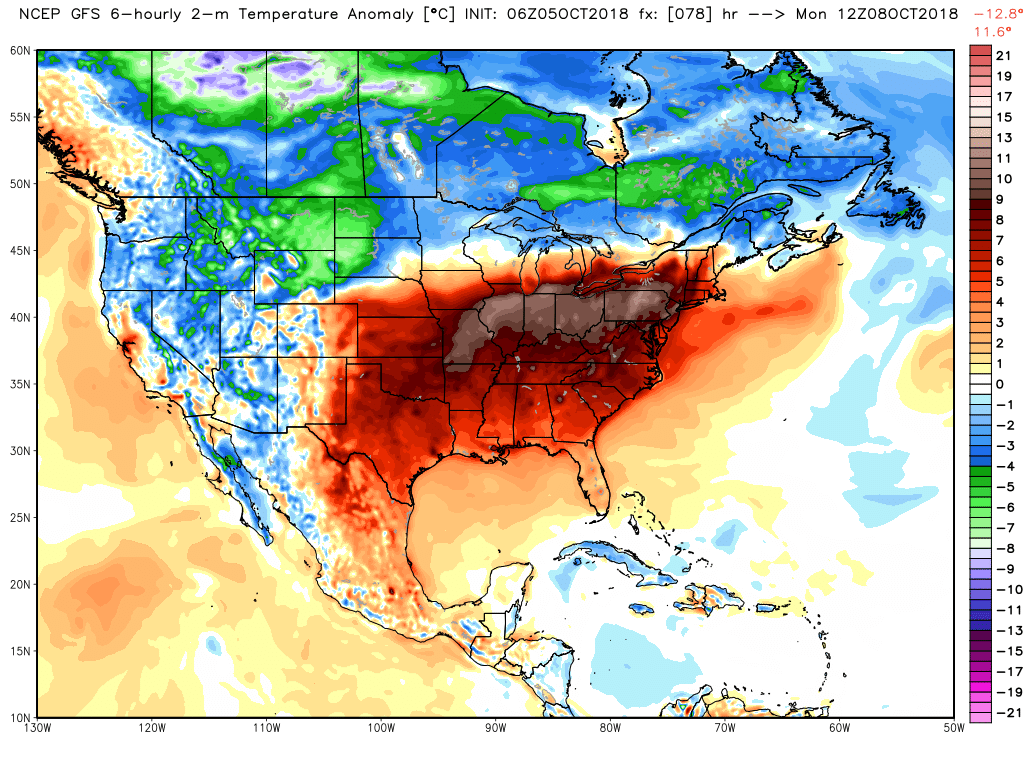
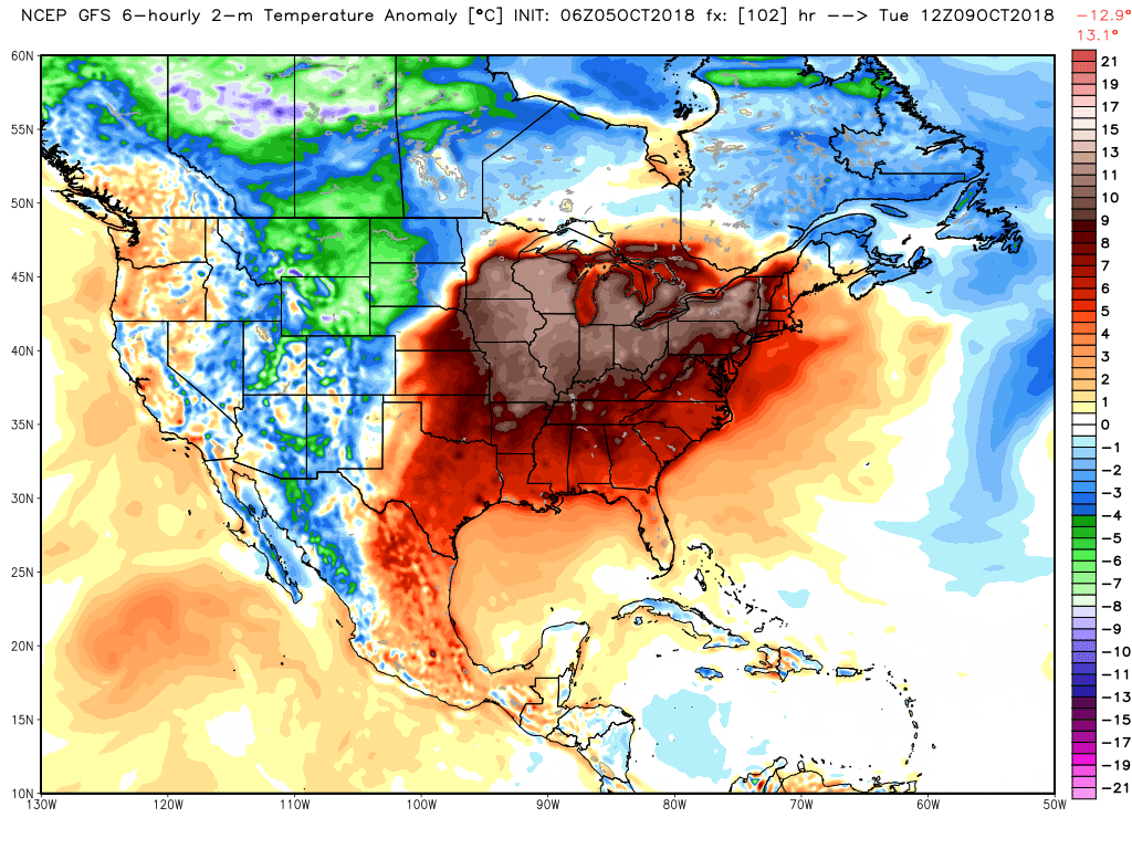
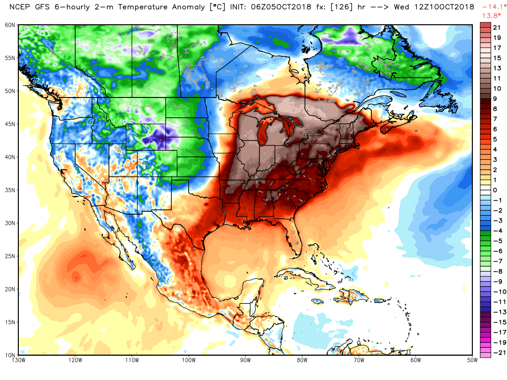
Check out the temperature anomaly map today through Wednesday.
Look at the sea of red. WELL above normal temperatures. What an amazing streak of warmth.
Today

Saturday
Sunday
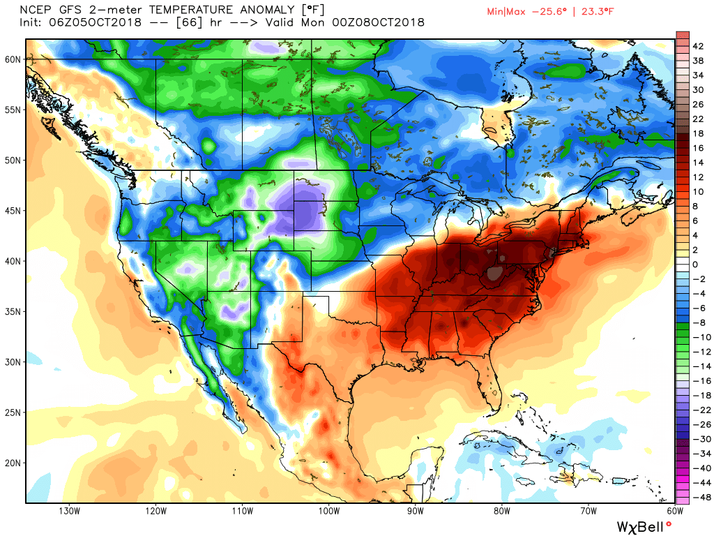
Monday
Tuesday
Wednesday
Then, as we move into late next week.
Quite amazing! I guess we will just have to enjoy the warm weather.
Thunderstorm chances today through Monday will be low. If there were some storms, they would most likely be in southeast Missouri and northern portions of southern Illinois. Even there, the chances are low.
Precipitation chances will increase as a cold front moves into the region Tuesday or Wednesday.
Tuesday and Wednesday
A cold front (much anticipated) will push into the region Tuesday or Wednesday.
This is the same front that has delivered flooding rains to portions of the central United States. Thankfully, the front should not stall in our region. That means the precipitation will be transient.
It is still a bit early to know if severe weather will be a concern. Don’t forget, we often do have severe weather in October and November. This does not appear to be an outbreak of severe weather. I did mention a low-end risk. I will monitor trends over the coming days.
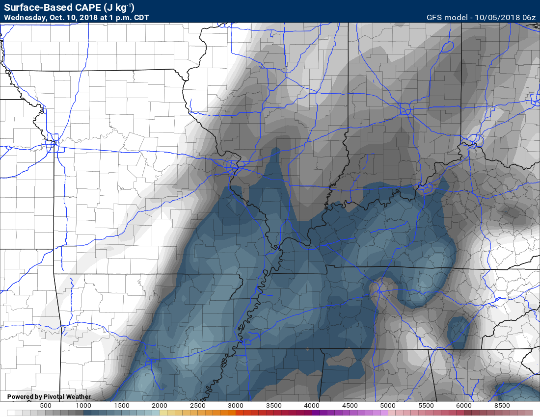
The GFS is showing some severe weather parameters.
Here is the CAPE outlook. CAPE is basically energy that storms can tap into. During the fall and winter months, CAPE numbers can be low and we still have severe weather. That is because wind shear is normally higher during the fall and winter months. The wind shear makes up the difference.
CAPE
Lifted Index
This just means the atmosphere is unstable. Lifted index is used mostlyl during the warm seasons. It is not as important during the fall and winter. That is because severe weather is dynamic driven during the fall and winter. That means we don’t need warm/hot temperatures to experience severe weather. The wind shear makes up the difference.

Bulk Shear
Wind shear is one ingredient for severe weather.
Higher wind shear helps the storm to move. This helps to keep the storm alive. Without wind shear, a thunderstorm updraft won’t last. The storm will collapse on itself and weaken.
Directional wind shear is a change of direction with height. Directional wind shear is important in determining whether thunderstorms will spin.
Wind shear is available next Wednesdsay.

EHI numbers are low. EHI is one parameter I monitor for the spin in the atmosphere.
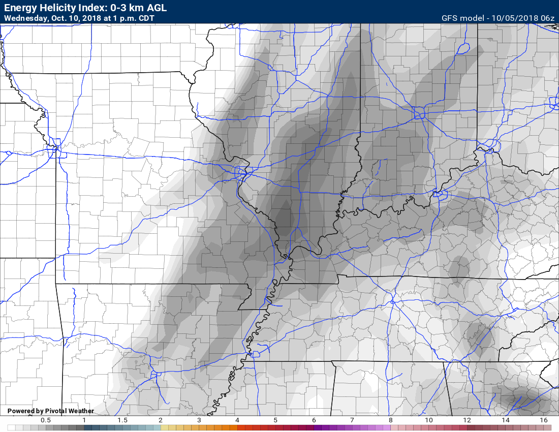
What does all of that mean?
It means that I will be monitoring trends in the guidance in order to determine if some thunderstorms will be severe next week. It is a bit early to know the answer to that.
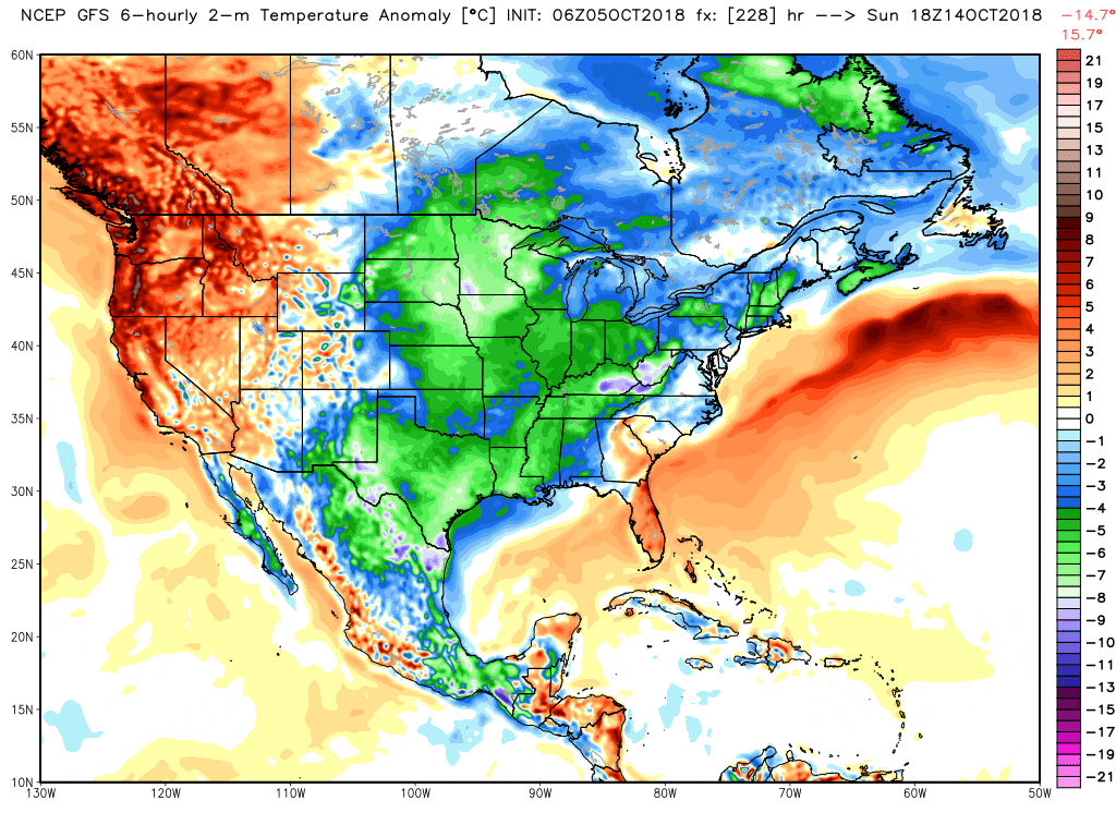
Temperatures should return to more seasonable levels as we move into the middle/end of next week. It does not appear to be a frost producing cold blast. Overnight lows might dip into the 40’s.
The models have shown cold blasts over the last few weeks. The models have been overdoing the cold temperatures.
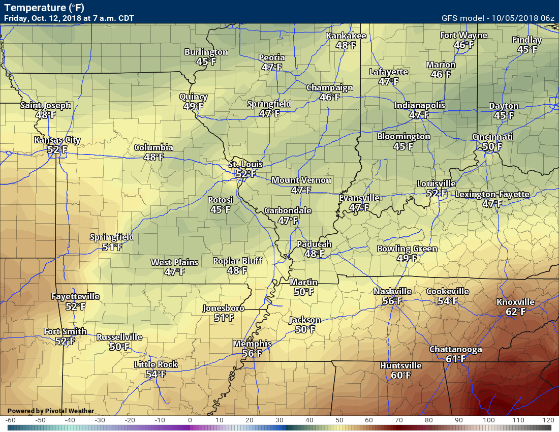
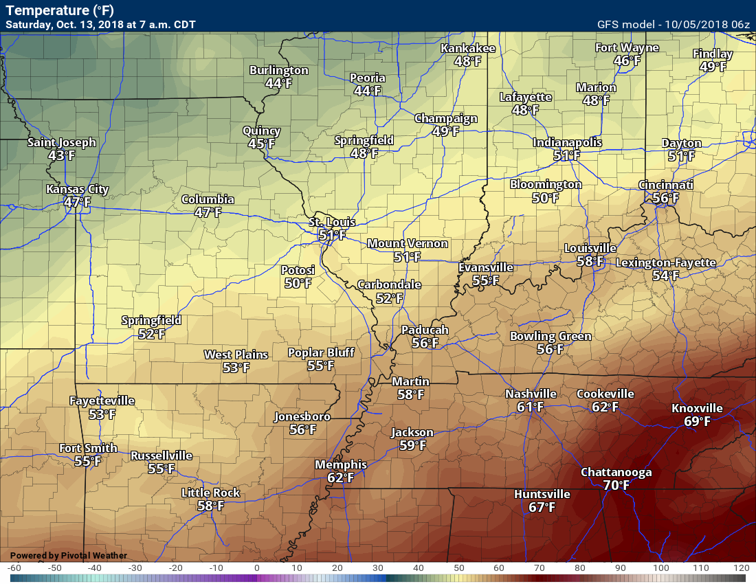
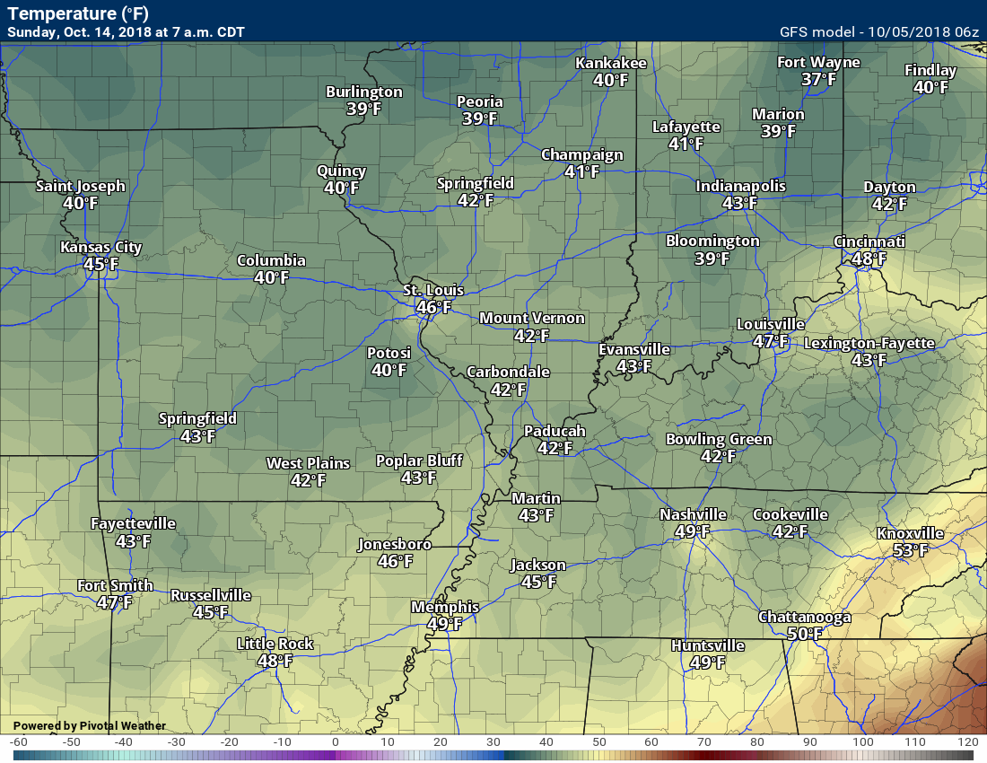
Check out this temperature animation. Can you find the cold front?
Fingers crossed, we may actually experience some cooler temperatures.
GFS has a cold bias. Keep that in mind. Here is what the GFS is showing for low temperatures next Friday into Sunday
Friday morning (October 12, 2018)
Saturday morning. October 13, 2018
Sunday, October 14, 2018
Monday, October 15, 2018
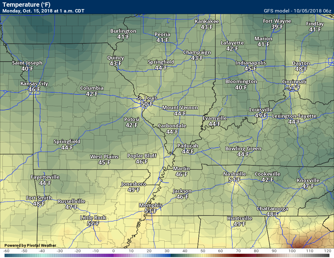
I will keep an eye on trends. I do believe it will be cooler. Just a matter of how cool.
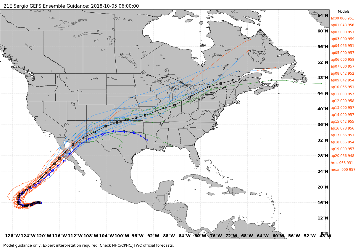
The remnants of Hurricane Sergio could bring additional rain late next week. This is a bit of a wild-card in the forecast. Sergio is a Pacific hurricane.
Long range outlooks show another strong cold front around October 20th through October 22nd. We will watch that one for thunderstorms and colder temperatures. Not sure about frost, just yet. I am monitoring that portion of the forecast.
![]()
Here is the preliminary fall outlook from the long-range meteorology team.
Click to enlarge this graphic.
.
![]()
The September forecast has been updated.
![]()

I bring these to you from the BAMwx team. They are excellent long-range forecasters.
Remember, long-range outlooks are a bit of skill, understanding weather patterns, and luck combined. It is not an exact science.

This product is for subscribers.
Subscribe at www.weathertalk.com
Subscriber graphics can be viewed on this page CLICK HERE

This product is for subscribers.

Subscriber graphics can be viewed on this page CLICK HERE
![]()
.
Fall Outlook!
Preliminary October precipitation outlook
Here is the preliminary November temperature and precipitation outlook
Preliminary November temperature outlook
Preliminary November precipitation outlook
.These products are for subscribers.
![]()

A new weather podcast is now available! Weather Geeks (which you might remember is on The Weather Channel each Sunday)
To learn more visit their website. Click here.
![]()

WeatherBrains Episode 663
Joining us as our Guest WeatherBrain this week is a hydrologist in the Research Applications Lab at NCAR. He has a background in hydrology, geology and computer science. In graduate school, he found a happy marriage of these in hydrological modeling, remote sensing, and more recently atmospheric modeling. Ethan Gutmann, welcome to WeatherBrains!
Other discussions in this weekly podcast include topics like:
- Should we re-do hurricane classification?
- Ethan’s hobby of mountain climbing
- U. S. Weather Roundup
- Remnants of Hurricane Rosa entering SW United States
- Astronomy Outlook with Tony Rice
- and more!
.
.
Link to their website https://weatherbrains.com/
Previous episodes can be viewed by clicking here.

We offer interactive local city live radars and regional radars. If a radar does not update then try another one. If a radar does not appear to be refreshing then hit Ctrl F5. You may also try restarting your browser.
The local city view radars also have clickable warnings.
During the winter months, you can track snow and ice by clicking the winterize button on the local city view interactive radars.
You may email me at beaudodson@usawx.com
Find me on Facebook!

Find me on Twitter!

Did you know that a portion of your monthly subscription helps support local charity projects?
You can learn more about those projects by visiting the Shadow Angel Foundation website and the Beau Dodson News website.

I encourage subscribers to use the app vs regular text messaging. We have found text messaging to be delayed during severe weather. The app typically will receive the messages instantly. I recommend people have three to four methods of receiving their severe weather information.
Remember, my app and text alerts are hand typed and not computer generated. You are being given personal attention during significant weather events.
