WeatherTalk monthly operating costs can top $2000.00. Your $5 subscription helps pay for those costs. I work for you.
The $5 will allow you to register up to seven phones!
For $5 a month you can receive the following. You may choose to receive these via your WeatherTalk app or regular text messaging.
Severe weather app/text alerts from my keyboard to your app/cell phone. These are hand typed messages from me to you. During tornado outbreaks, you will receive numerous app/text messages telling you exactly where the tornado is located.
- Daily forecast app/texts from my computer to your app/cell phone.
- Social media links sent directly to your app/cell phone. When I update the blog, videos, or Facebook you will receive the link.
- AWARE emails. These emails keep you well ahead of the storm. They give you several days of lead time before significant weather events.
- Direct access to Beau via text and email. Your very own personal meteorologist. I work for you!
- Missouri and Ohio Valley centered video updates
- Long-range weather videos
- Week one, two, three and four temperature and precipitation outlooks.
Monthly outlooks. - Your subscription also will help support several local charities.
Would you like to subscribe? Subscribe at www.beaudodsonweather.com
Typical progression on a severe weather day for subscribers.


I encourage subscribers to use the app vs regular text messaging. We have found text messaging to be delayed during severe weather. The app typically will receive the messages instantly. I recommend people have three to four methods of receiving their severe weather information.
Remember, my app and text alerts are hand typed and not computer generated. You are being given my personal attention during significant weather events.

WWW.WEATHERTALK.COM subscribers, here is my day to day schedule for your weather products.
These are bonus videos and maps for subscribers. I bring these to you from the BAMwx team. I pay them to help with videos.
The Ohio and Missouri Valley videos cover most of our area. They do not have a specific Tennessee Valley forecast but may add one in the future.
The long-range video is technical. Over time, you can learn a lot about meteorology from the long range video. Just keep in mind, it is a bit more technical.


.
![]()

October 29, 2018
Monday forecast: Mostly sunny and mild.
Temperatures: MO ~ 65 to 70 IL ~ 65 to 70 KY ~ 65 to 70 TN ~ 65 to 70
What is the chance of precipitation? MO ~ 0% IL ~ 0% KY ~ 0% TN ~ 0%
Coverage of precipitation: None
Wind: Winds becoming south at 5 to 10 mph
What impacts are anticipated from the weather? None
My confidence in the forecast verifying: High
Is severe weather expected? No
The NWS defines severe weather as 58 mph wind or great, 1″ hail or larger, and/or tornadoes
Should I cancel my outdoor plans? No
UV Index: 6 to 8 moderate to high
Sunrise: 7:17 AM
Monday Night Forecast Details:
Forecast: Mostly clear.
Temperatures: MO ~ 48 to 54 IL ~ 46 to 42 KY ~ 48 to 52 TN ~ 48 to 54
What is the chance of precipitation? MO ~ 0% IL ~ 0% KY ~ 0% TN ~ 0%
Coverage of precipitation: None
Frost Risk: None
Wind: Winds becoming southeast at 5 to 10 mph
What impacts are anticipated from the weather? None
My confidence in the forecast verifying:High
Is severe weather expected? No
The NWS defines severe weather as 58 mph wind or great, 1″ hail or larger, and/or tornadoes
Should I cancel my outdoor plans? No
Sunset: 6:00 PM
Moonrise: 10:24 PM Waning Gibbous
Moonset: 12:17 PM
October 30, 2018
Tuesday forecast: Mostly sunny. Windy. Warm. Temperatures could approach 80 degrees in some locations.
Temperatures: MO ~ 75 to 78 IL ~ 75 to 78 KY ~ 75 to 78 TN ~ 75 to 78
What is the chance of precipitation? MO ~ 0% IL ~ 0% KY ~ 0% TN ~ 0%
Coverage of precipitation: None anticipated
Wind: South and southwest at 15 to 30 mph and gusty
What impacts are anticipated from the weather? None.
My confidence in the forecast verifying: High
Is severe weather expected? No
The NWS defines severe weather as 58 mph wind or great, 1″ hail or larger, and/or tornadoes
Should I cancel my outdoor plans? No
UV Index: 6 to 8 High
Sunrise: 7:18 AM
Tuesday Night Forecast Details:
Forecast: Increasing clouds. Rain developing from NW to SE. A thunderstorm possible, especially late at night.
Temperatures: MO ~ 56 to 60 IL ~ 55 to 60 KY ~ 56 to 60 TN ~ 58 to 62
What is the chance of precipitation? MO ~ 70% IL ~ 70% KY ~ 60% TN ~ 60%
Coverage of precipitation: Increasing coverage ahead and behind a cold front.
Frost Risk: No
Wind: South at 7 to 14 mph with higher gusts
What impacts are anticipated from the weather? Wet roadways. Isolated lightning possible.
My confidence in the forecast verifying: High
Is severe weather expected? No
The NWS defines severe weather as 58 mph wind or great, 1″ hail or larger, and/or tornadoes
Should I cancel my outdoor plans? No
Sunset: 5:59 PM
Moonrise: 10:24 PM Waning Gibbous
Moonset: 12:17 PM
October 31, 2018
A trick instead of a treat. Rain likely.
Wednesday forecast: Rain. Rain moderate at times. Mild ahead of the front and turning colder behind the front.
Temperatures: MO ~ falling into the upper 50’s to middle 60’s IL ~ Falling into the upper 50’s over northern parts of southern Illinois and highs in the middle 60’s elsewhere KY ~ 64 to 68 TN ~ 66 to 72
What is the chance of precipitation? MO ~ 100% IL ~ 100% KY ~ 100% TN ~ 90%
Coverage of precipitation: Widespread
Wind: South at 6 to 12 mph. Winds will shift behind the cold front and become west and northwest.
What impacts are anticipated from the weather? Lightning possible. Wet roadways. Some low land flooding possible (fields and ditches)
My confidence in the forecast verifying: High
Is severe weather expected? No
The NWS defines severe weather as 58 mph wind or great, 1″ hail or larger, and/or tornadoes
Should I cancel my outdoor plans? Yes, have a plan B
UV Index: 1 to 2 Low
Sunrise: 7:19 AM
Wednesday Night Forecast Details:
Forecast: Cloudy. Rain. Rain moderate to heavy, at times. Northern parts of southeast Missouri and northern parts of southern Illinois may end up drier than the rest of the area. Keep this in mind.
Temperatures: MO ~ 44 to 48 IL ~ 44 to 48 KY ~ 44 to 48 TN ~ 44 to 48
What is the chance of precipitation? MO ~ 40% north and 80% elsewhere IL ~ 40% north and 80% elsewhere KY ~ 100% TN ~ 100%
Coverage of precipitation: Numerous to widespread
Frost Risk: None
Wind: West and northwest at 6 to 12 mph
What impacts are anticipated from the weather? Wet roadways. Low land flooding possible.
My confidence in the forecast verifying: High
Is severe weather expected? No
The NWS defines severe weather as 58 mph wind or great, 1″ hail or larger, and/or tornadoes
Should I cancel my outdoor plans? Have a plan B
Sunset: 5:58 PM
Moonrise: 11:59 PM Waning Gibbous
Moonset: 2:03 PM
November 1, 2018
Thursday forecast: Cloudy. Rain showers likely. Cooler.
Temperatures: MO ~ 52 to 54 IL ~ 52 to 54 KY ~ 54 to 56 TN ~ 54 to 56
What is the chance of precipitation? MO ~ 50% IL ~ 50% KY ~ 50% TN ~ 50%
Coverage of precipitation: Scattered to perhaps numerous
Wind: North at 8 to 16 mph
What impacts are anticipated from the weather? Wet roadways
My confidence in the forecast verifying: Medium
Is severe weather expected? No
The NWS defines severe weather as 58 mph wind or great, 1″ hail or larger, and/or tornadoes
Should I cancel my outdoor plans? Have a plan B
UV Index: 1 to 3 Low
Sunrise: 7:20 AM
Thursday Night Forecast Details:
Forecast: Cloudy. A shower possible. Rain should be ending.
Temperatures: MO ~ 36 to 40 IL ~ 36 to 40 KY ~ 38 to 42 TN ~ 38 to 44
What is the chance of precipitation? MO ~ 30% IL ~ 30% KY ~ 30% TN ~ 30%
Coverage of precipitation: Scattered
Frost Risk: Most likely no
Wind: Northwest at 7 to 14 mph
What impacts are anticipated from the weather? Wet roadways
My confidence in the forecast verifying: Medium to high
Is severe weather expected? No
The NWS defines severe weather as 58 mph wind or great, 1″ hail or larger, and/or tornadoes
Should I cancel my outdoor plans? Have a plan B
Sunset: 5:57 PM
Moonrise: 12:33 PM Last Quarter
Moonset: 2:47 PM
November 2, 2018
Friday forecast: Increasing clouds with a chance of showers.
Temperatures: MO ~ 54 to 58 IL ~ 54 to 58 KY ~ 56 to 60 TN ~ 58 to 62
What is the chance of precipitation? MO ~ 40% IL ~ 40% KY ~ 40% TN ~ 40%
Coverage of precipitation: Scattered
Wind: South and southwest at 5 to 10 mph
What impacts are anticipated from the weather? Wet roadways
My confidence in the forecast verifying: Medium
Is severe weather expected? No
The NWS defines severe weather as 58 mph wind or great, 1″ hail or larger, and/or tornadoes
Should I cancel my outdoor plans? I would monitor updates as rain is possible
UV Index: 4 to 5 Moderate
Sunrise: 7:21 AM
Friday Night Forecast Details:
Forecast: Cloudy with showers ending.
Temperatures: MO ~ 35 to 40 IL ~ 35 to 40 KY ~ 36 to 42 TN ~ 40 to 44
What is the chance of precipitation? MO ~ 30% IL ~ 30% KY ~ 30% TN ~ 30%
Coverage of precipitation: Scattered
Frost Risk: Most likely no
Wind: Winds becoming west and northwest at 5 to 10 mph with gusts to 14 mph
What impacts are anticipated from the weather? Wet roadways
My confidence in the forecast verifying: Medium
Is severe weather expected? No
The NWS defines severe weather as 58 mph wind or great, 1″ hail or larger, and/or tornadoes
Should I cancel my outdoor plans? Monitor updates
Sunset: 5:56 PM
Moonrise: 1:41 AM Waning Crescent
Moonset: 3:26 PM
November 3, 2018
Saturday forecast: Partly sunny and cool.
Temperatures: MO ~ 54 to 58 IL ~54 to 58 KY ~ 55 to 60 TN ~ 55 to 60
What is the chance of precipitation? MO ~ 0% IL ~ 0% KY ~ 0% TN ~ 0%
Coverage of precipitation: None
Wind: West at 6 to 12 mph
What impacts are anticipated from the weather? None
My confidence in the forecast verifying: Medium
Is severe weather expected? No
The NWS defines severe weather as 58 mph wind or great, 1″ hail or larger, and/or tornadoes
Should I cancel my outdoor plans? No
UV Index: 4 to5 Moderate
Sunrise: 7:22 AM
Saturday Night Forecast Details:
Forecast: Partly cloudy.
Temperatures: MO ~ 38 to 42 IL ~ 38 to 42 KY ~ 38 to 42 TN ~ 40 to 44
What is the chance of precipitation? MO ~ 0% IL ~ 0% KY ~ 0% TN ~ 0%
Coverage of precipitation: None
Frost Risk: Possible
Wind: Becoming east and southeast at 5 to 10 mph with gusts to 14 mph
What impacts are anticipated from the weather? None
My confidence in the forecast verifying: Medium
Is severe weather expected? No
The NWS defines severe weather as 58 mph wind or great, 1″ hail or larger, and/or tornadoes
Should I cancel my outdoor plans? No
Sunset: 5:55 PM
Moonrise: 2:49 PM Waning Crescent
Moonset: 4:03 PM
November 4, 2018
Sunday forecast: Mostly cloudy with showers possible.
Temperatures: MO ~ 58 to 64 IL ~ 58 to 64 KY ~ 58 to 64 TN ~ 58 to 64
What is the chance of precipitation? MO ~ 40% IL ~ 40% KY ~ 40% TN ~ 40%
Coverage of precipitation: Scattered
Wind:
What impacts are anticipated from the weather? Wet roadways
My confidence in the forecast verifying: Medium
Is severe weather expected? No
The NWS defines severe weather as 58 mph wind or great, 1″ hail or larger, and/or tornadoes
Should I cancel my outdoor plans? Monitor updates
UV Index: 2 to 3 Low
Sunrise: 6:23 AM
Sunday Night Forecast Details:
Forecast: Mostly cloudy. A shower again possible.
Temperatures: MO ~ 44 to 48 IL ~ 44 to 48 KY ~ 44 to 48 TN ~ 44 to 48
What is the chance of precipitation? MO ~ 40% IL ~ 40% KY ~ 40% TN ~ 40%
Coverage of precipitation: Scattered
Frost Risk:
Wind:
What impacts are anticipated from the weather? Wet roadways.
My confidence in the forecast verifying: Medium
Is severe weather expected? No
The NWS defines severe weather as 58 mph wind or great, 1″ hail or larger, and/or tornadoes
Should I cancel my outdoor plans? Monitor updates
Sunset: 4:54 PM
Moonrise: 2:56 PM Waning Gibbous
Moonset: 3:37 PM
November 5, 2018
Monday forecast: Partly cloudy. A shower possible.
Temperatures: MO ~ 55 to 60 IL ~ 55 to 60 KY ~ 55 to 60 TN ~ 55 to 60
What is the chance of precipitation? MO ~ 30% IL ~ 30% KY ~ 30% TN ~ 30%
Coverage of precipitation: Scattered
Wind:
What impacts are anticipated from the weather? Wet roadways
My confidence in the forecast verifying: Low
Is severe weather expected? No
The NWS defines severe weather as 58 mph wind or great, 1″ hail or larger, and/or tornadoes
Should I cancel my outdoor plans? Monitor updates
UV Index: 2 to 3 Low
Sunrise: 6:24 AM
Monday Night Forecast Details:
Forecast: Partly cloudy and cool.
Temperatures: MO ~ 44 to 48 IL ~ 44 to 48 KY ~ 44 to 48 TN ~ 44 to 48
What is the chance of precipitation? MO ~ 0% IL ~ 0% KY ~ 0% TN ~ 0%
Coverage of precipitation: None
Frost Risk:
Wind:
What impacts are anticipated from the weather? None
My confidence in the forecast verifying: Low
Is severe weather expected? No
The NWS defines severe weather as 58 mph wind or great, 1″ hail or larger, and/or tornadoes
Should I cancel my outdoor plans? No
Sunset: 4:53 PM
Moonrise: 4:02 PM Waning Gibbous
Moonset: 4:09 PM
Learn more about the UV index readings. Click here.

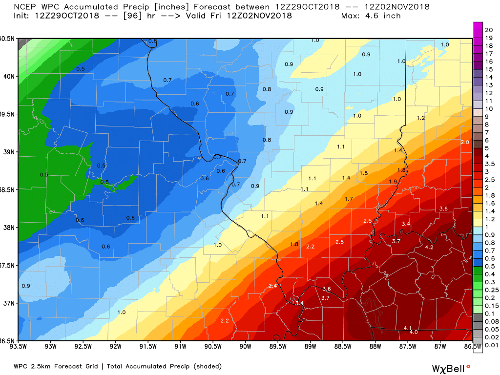
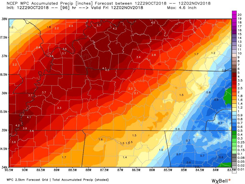
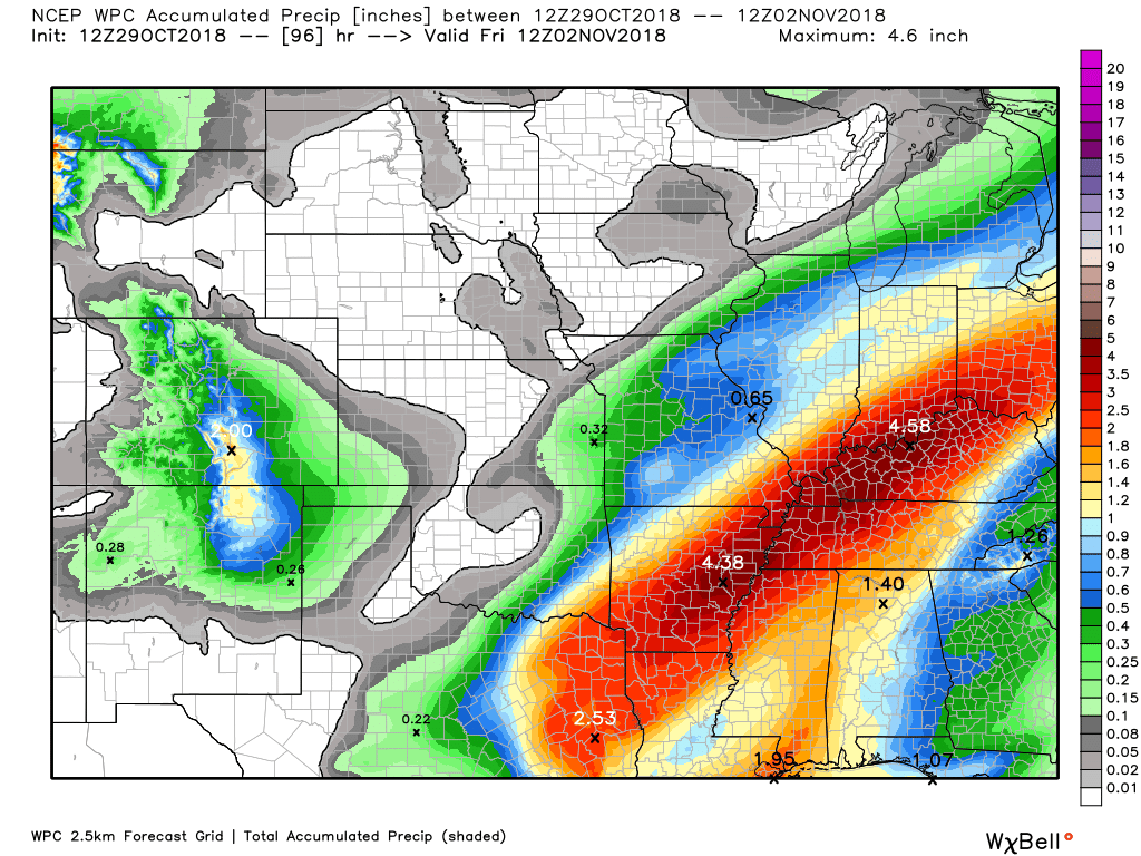
Here is the WPC/NOAA rainfall outlook
This is from now through Friday morning.
Most of this will fall Tuesday night into Thursday morning. The peak of the rain will be Wednesday and Wednesday night.
Locally heavy rain totals are likely with this event. The greatest rain totals are forecast to be along and east of the Mississippi River.
Zooming in on southeast Missouri and southern Illinois
Zooming in on southern Illinois and western Kentucky/Tennessee
Regional view
Did you know that you can find me on Twitter?

Subscribers, do you need a forecast for an outdoor event?


We offer interactive local city live radars and regional radars.
If a radar does not update then try another one. If a radar does not appear to be refreshing then hit Ctrl F5 on your keyboard.
You may also try restarting your browser. The local city view radars also have clickable warnings.
During the winter months, you can track snow and ice by clicking the winterize button on the local city view interactive radars.

Questions? Broken links? Other questions?
You may email me at beaudodson@usawx.com

The National Weather Service defines a severe thunderstorm as one that produces quarter size hail or larger, 58 mph winds or greater, and/or a tornado.
Today through next Saturday: Severe weather is not anticipated. Lightning is possible Tuesday night and Wednesday. Moderate to heavy rain is possible Wednesday and Wednesday night. A wet Halloween.
Interactive live weather radar page. Choose the city nearest your location. If one of the cities does not work then try a nearby one. Click here.
National map of weather watches and warnings. Click here.
Storm Prediction Center. Click here.
Weather Prediction Center. Click here.

Live lightning data: Click here.

Interactive GOES R satellite. Track clouds. Click here.

Here are the latest local river stage forecast numbers Click Here.
Here are the latest lake stage forecast numbers for Kentucky Lake and Lake Barkley Click Here.

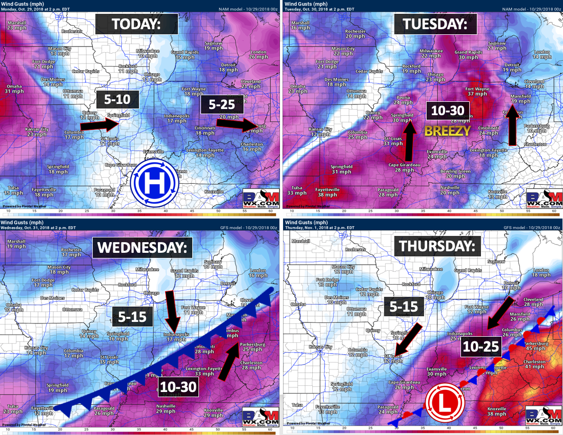
- Warm today into Tuesday
- Gusty winds Tuesday
- Increasing rain chances Tuesday night, Wednesday, Wednesday night, and Thursday
- Monitoring rain chances Friday, Sunday, and Monday
- Dry weather likely Saturday
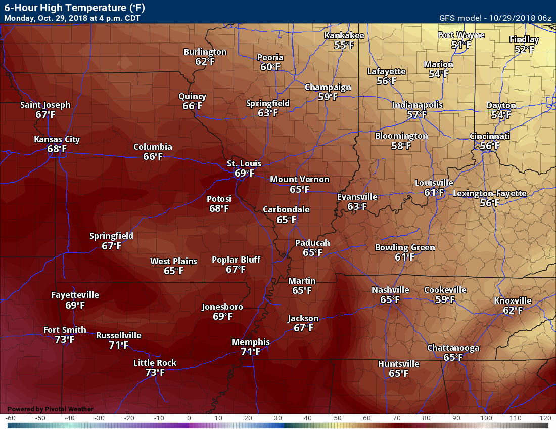
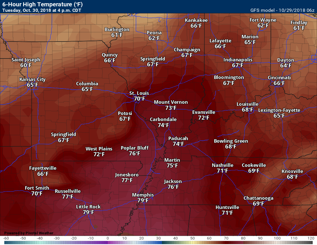
The big weather story today and Tuesday will be mild temperatures. As a matter of fact, someone might hit 80 degrees by Tuesday afternoon!
You can click any of the images on this page to enlarge them.
Today’s high temperatures
Tuesday high temperatures
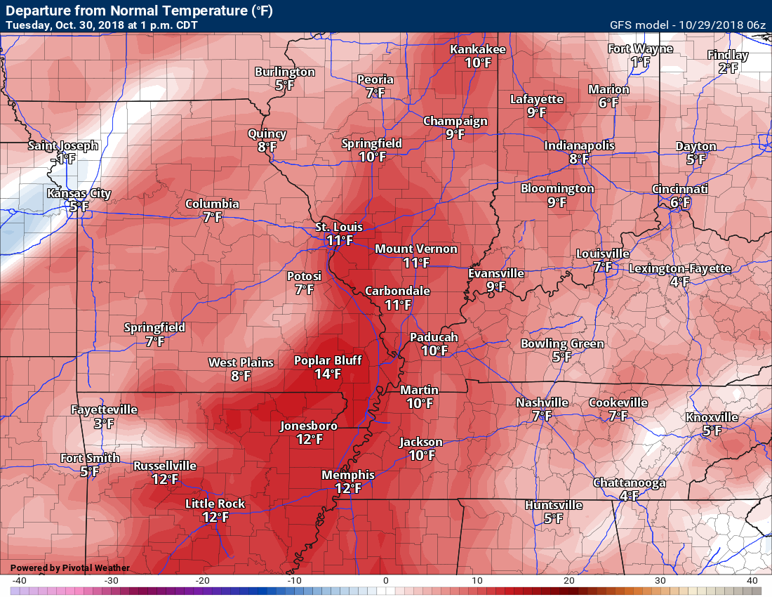
Temperature anomalies at 1 PM Tuesday (well above normal)
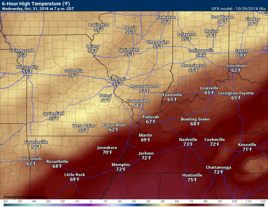
Wednesday high temperatures
Notice the cold front Wednesday? The front will move northwest to southeast. You can see warm air ahead of the front and cooler air behind the front.
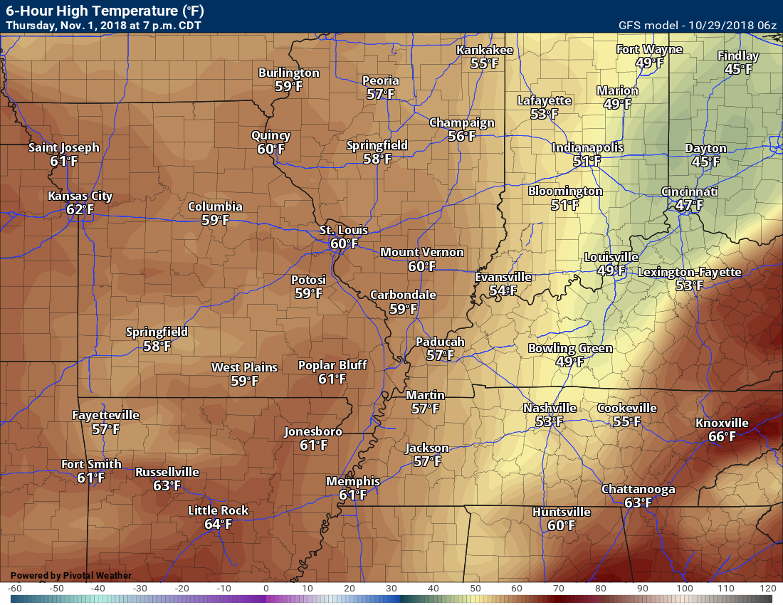
Thursday high temperatures
We will have windy conditions by Tuesday and that will linger into Wednesday.
Here is the wind gust map for Tuesday afternoon. We will see plenty of 10 to 20 mph wind gusts with occasional 30+ mph gusts.
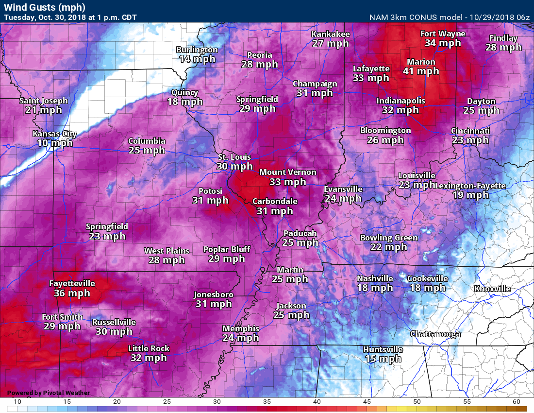
Those gusty winds are going to signal a change in the weather.
Rain chances increasing by Tuesday night.
A cold front will push into the region Tuesday night and Wednesday. The front will approach from the northwest and move southeast.
Showers and thunderstorms will accompany the cold front. The heaviest rain will be along and north of the front.
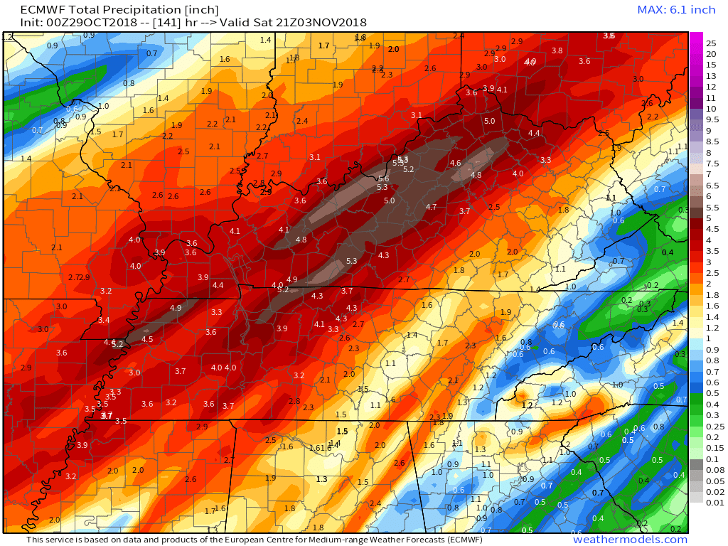
Rain totals are likely to be from one to two inches with pockets of two to three+ inches.
The highest risk of the heavier totals will be along and east/southeast of the Mississippi River.
Kentucky and Tennessee will most likely experience the heaviest rain totals.
The rain will be spread out over a 48 to 72 hour period of time. This should help prevent flash flooding. I can’t rule out, however, some ditches filling with water, a few roads with water issues, ponding of water on roadways, and low land field flooding.
The heaviest rain will fall Wednesday into Wednesday night.
Unfortunately, Halloween trick or treaters will have to dodge raindrops.
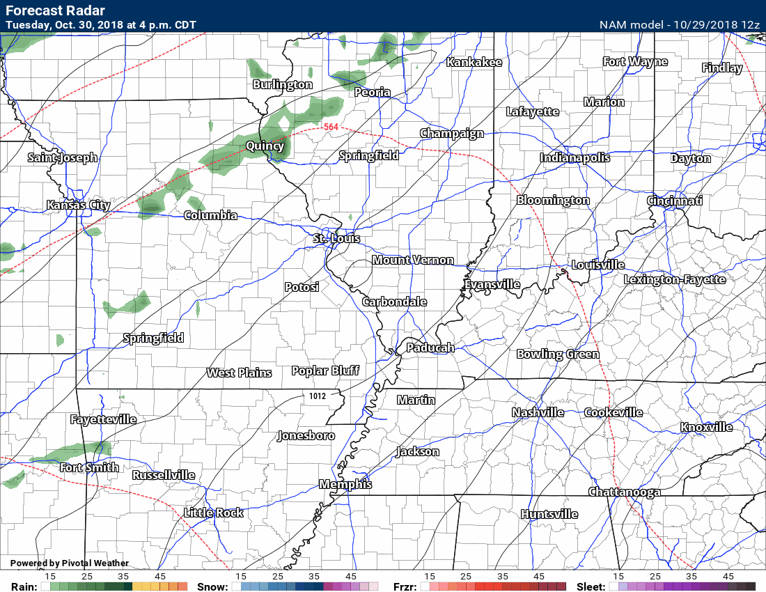
Here is the NAM future-cast radar. This is what the NAM model believes radar will look like by Tuesday night into Thursday.
The time-stamp is located in the upper left corner of the animation.
Click to enlarge.
Notice how our northern counties may dry out by Wednesday evening into Wednesday night. Elsewhere, widespread rain. Keep this in mind. Some areas may dry out.
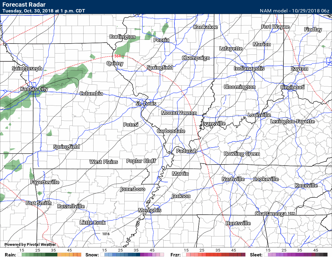
Here is the latest run that just came in (8 AM data)
Here is the GFS rainfall totals forecast. You can see the heaviest rain totals over Kentucky and Tennessee. Respectable totals, elsewhere.
Click to enlarge the animation.
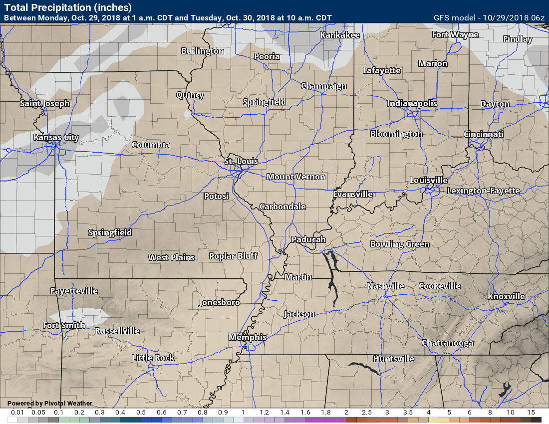
GFS totals

EC model rain totals (another model)
Rain showers will continue into Thursday, as well.
Friday into Sunday
I am watching two more cold fronts. One arrives by Friday and the other by Sunday. Both could have rain showers accompanying their passage.
At this time, Saturday appears to be the pick day of the weekend. Dry conditions are forecast. Medium confidence on that part of the forecast.
Active pattern.
No bitterly cold air in the charts. Seasonably cold air likely.
![]()

I bring these to you from the BAMwx team. They are excellent long-range forecasters.
Remember, long-range outlooks are a bit of skill, understanding weather patterns, and luck combined. It is not an exact science.

This product is for subscribers.
Subscribe at www.weathertalk.com
Subscriber graphics can be viewed on this page CLICK HERE

This product is for subscribers.

This product is for subscribers.
Subscribe at www.weathertalk.com
Subscriber graphics can be viewed on this page CLICK HERE
![]()
.
Fall Outlook!
Preliminary October precipitation outlook
.
Here is the preliminary November temperature and precipitation outlook
.
Preliminary November temperature outlook
Preliminary November precipitation outlook
.These products are for subscribers.
![]()

A new weather podcast is now available! Weather Geeks (which you might remember is on The Weather Channel each Sunday)
To learn more visit their website. Click here.
![]()

WeatherBrains Episode 666
This week’s Guest WeatherBrain is a world-renowned meteorologist, prognosticator, and extended outlook specialist. A 1978 graduate of Penn State University with a Bachelor of Science in Meteorology and former Nittany Lion Wrestler, he worked at AccuWeather soon after graduation. He currently works for WeatherBELL Analytics as co-Chief Forecaster. Joe Bastardi, welcome to WeatherBrains!
Other discussions in this weekly podcast include topics like:
Other discussions in this weekly podcast include topics like:
Hurricane Willa approaches the Mexican coast
Winter weather outlook from the panel
Astronomy Outlook with Tony Rice
and more!
Link to their website https://weatherbrains.com/
Previous episodes can be viewed by clicking here.

We offer interactive local city live radars and regional radars. If a radar does not update then try another one. If a radar does not appear to be refreshing then hit Ctrl F5. You may also try restarting your browser.
The local city view radars also have clickable warnings.
During the winter months, you can track snow and ice by clicking the winterize button on the local city view interactive radars.
You may email me at beaudodson@usawx.com
Find me on Facebook!

Find me on Twitter!

Did you know that a portion of your monthly subscription helps support local charity projects?
You can learn more about those projects by visiting the Shadow Angel Foundation website and the Beau Dodson News website.

I encourage subscribers to use the app vs regular text messaging. We have found text messaging to be delayed during severe weather. The app typically will receive the messages instantly. I recommend people have three to four methods of receiving their severe weather information.
Remember, my app and text alerts are hand typed and not computer generated. You are being given personal attention during significant weather events.
