WeatherTalk monthly operating costs can top $2000.00. Your $5 subscription helps pay for those costs. I work for you.
The $5 will allow you to register up to seven phones!
For $5 a month you can receive the following. You may choose to receive these via your WeatherTalk app or regular text messaging.
Severe weather app/text alerts from my keyboard to your app/cell phone. These are hand typed messages from me to you. During tornado outbreaks, you will receive numerous app/text messages telling you exactly where the tornado is located.
- Daily forecast app/texts from my computer to your app/cell phone.
- Social media links sent directly to your app/cell phone. When I update the blog, videos, or Facebook you will receive the link.
- AWARE emails. These emails keep you well ahead of the storm. They give you several days of lead time before significant weather events.
- Direct access to Beau via text and email. Your very own personal meteorologist. I work for you!
- Missouri and Ohio Valley centered video updates
- Long-range weather videos
- Week one, two, three and four temperature and precipitation outlooks.
Monthly outlooks. - Your subscription also will help support several local charities.
Would you like to subscribe? Subscribe at www.beaudodsonweather.com

I encourage subscribers to use the app vs regular text messaging. We have found text messaging to be delayed during severe weather. The app typically will receive the messages instantly. I recommend people have three to four methods of receiving their severe weather information.
Remember, my app and text alerts are hand typed and not computer generated. You are being given my personal attention during significant weather events.

WWW.WEATHERTALK.COM subscribers, here is my day to day schedule for your weather products.
These are bonus videos and maps for subscribers. I bring these to you from the BAMwx team. I pay them to help with videos.
The Ohio and Missouri Valley videos cover most of our area. They do not have a specific Tennessee Valley forecast but may add one in the future.
The long-range video is technical. Over time, you can learn a lot about meteorology from the long range video. Just keep in mind, it is a bit more technical.


.
![]()

.

October 12, 2018
Friday forecast: Mostly sunny during the morning. Increasing clouds through the day. Light rain developing from west to east during mainly the afternoon hours.
Temperatures: MO ~ 50 to 55 IL ~ 52 to 56 KY ~ 55 to 60 TN ~ 55 to 60
What is the chance of precipitation? MO ~ 50% to 60% IL ~ 50% to 60% KY ~ 40% to 50% TN ~ 40% to 50%
Coverage of precipitation: None early and then increasing coverage during the afternoon and evening hours. Light rain.
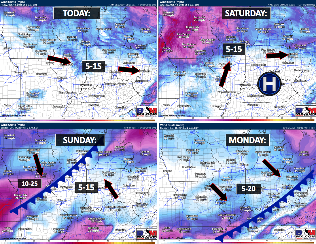
Wind: North and northwest at 6 to 12 mph
What impacts are anticipated from the weather? None during the morning. Wet roadways during the afternoon and evening hours.
My confidence in the forecast verifying: High
Is severe weather expected? No
The NWS defines severe weather as 58 mph wind or great, 1″ hail or larger, and/or tornadoes
Should I cancel my outdoor plans? Not during the morning. Afternoon hours will likely see rain appearing on radar and moving west to east through the area.
UV Index: 3 to 5 moderate
Sunrise: 7:00 AM
Friday Night Forecast Details:
Forecast: Mostly cloudy early. Light showers possible before 12 AM. Chilly. Clearing late.
Temperatures: MO ~ 38 to 44 IL ~ 38 to 44 KY ~ 40 to 44 TN ~ 40 to 44
What is the chance of precipitation? MO ~ 30% ending IL ~ 30% ending KY ~ 40% first half of the night TN ~ 40% first half of the night
Coverage of precipitation: Patchy light rain possible.
Frost Risk: Most likely no frost, but monitor updates.
Wind: North and northeast at 5 to 10 mph
What impacts are anticipated from the weather? A few wet roadways before midnight.
My confidence in the forecast verifying: High
Is severe weather expected? No
The NWS defines severe weather as 58 mph wind or great, 1″ hail or larger, and/or tornadoes
Should I cancel my outdoor plans? Have a plan B and monitor radars. Some light rain is possible in the region.
Sunset: 6:12 PM
Moonrise: 10:31 AM Waxing Crescent
Moonset: 9:02 PM
October 13, 2018
Saturday forecast: Cool. Some morning clouds. Becoming sunny. Late in the afternoon, a few more clouds may spread into the region from the southwest.
Temperatures: MO ~ 54 to 58 IL ~ 54 to 58 KY ~ 54 to 58 TN ~ 54 to 58
What is the chance of precipitation? MO ~ 10% IL ~ 0% KY ~ 0% TN ~ 0%
Coverage of precipitation: Most likely none
Wind: Northeast wind becoming east and southeast at 5 to 10 mph
What impacts are anticipated from the weather? Most likely none
My confidence in the forecast verifying: High
Is severe weather expected? No
The NWS defines severe weather as 58 mph wind or great, 1″ hail or larger, and/or tornadoes
Should I cancel my outdoor plans? No
UV Index: 5 moderate
Sunrise: 7:01 AM
Saturday Night Forecast Details:
Forecast: Increasing cloud cover. Rain developing from southwest to northeast. Most of the rain will occur late in the night. The first part of the night should remain dry, but monitor updates in case the rain arrives earlier than anticipated.
Temperatures: MO ~ 44 to 48 IL ~ 44 to 48 KY ~ 44 to 48 TN ~ 44 to 48
What is the chance of precipitation? MO ~ 60% IL ~ 60% KY ~ 60% TN ~ 60%
Coverage of precipitation: Increasing rain coverage through the night.
Frost Risk: None
Wind: East and southeast at 4 to 8 mph
What impacts are anticipated from the weather? Wet roadways.
My confidence in the forecast verifying: Medium
Is severe weather expected? No
The NWS defines severe weather as 58 mph wind or great, 1″ hail or larger, and/or tornadoes
Should I cancel my outdoor plans? Have a plan B and monitor updates. Rain should spread from southwest to northeast. It is possible the rain holds off until later in the night. Rain will arrive first along the Missouri and Arkansas border.
Sunset: 6:21 PM
Moonrise: 11:30 AM Waxing Crescent
Moonset: 9:44 PM
October 14, 2018
Sunday forecast: Mostly cloudy. Rain likely. An isolated thunderstorm possible.
Temperatures: MO ~ 54 to 58 IL ~ 54 to 58 KY ~ 55 to 60 TN ~ 55 to 60
What is the chance of precipitation? MO ~ 80% IL ~ 80% KY ~ 80% TN ~ 80%
Coverage of precipitation: Becoming widespread
Wind: East winds at 6 to 12 mph
What impacts are anticipated from the weather? Wet roadways. Lightning possible.
My confidence in the forecast verifying: Medium
Is severe weather expected? No
The NWS defines severe weather as 58 mph wind or great, 1″ hail or larger, and/or tornadoes
Should I cancel my outdoor plans? Have a plan B
UV Index: 1 to 3 Low
Sunrise: 7:02 AM
Sunday Night Forecast Details:
Forecast: Mostly cloudy. Rain likely. An isolated thunderstorm possible. Chilly.
Temperatures: MO ~ 42 to 44 IL ~ 44 to 46 KY ~ 46 to 48 TN ~ 46 to 48
What is the chance of precipitation? MO ~ 40% to 50% IL ~ 60% KY ~ 70% TN ~ 70%
Coverage of precipitation: Scattered to perhaps numerous
Frost Risk: None
Wind: North at 7 to 14 mph and gusty
What impacts are anticipated from the weather? Wet roadways. Low risk of lightning.
My confidence in the forecast verifying Medium
Is severe weather expected? No
The NWS defines severe weather as 58 mph wind or great, 1″ hail or larger, and/or tornadoes
Should I cancel my outdoor plans? Have a plan B
Sunset: 6:19 PM
Moonrise: 12:26 PM Waxing Crescent
Moonset: 10:29 PM
October 15, 2018
Monday forecast: Quite a few clouds. A chance of rain showers. Chilly temperatures.
Temperatures: MO ~ 48 to 54 IL ~ 48 to 54 KY ~ 50 to 54 TN ~ 50 to 54
What is the chance of precipitation? MO ~ 40% to 50% IL ~ 40% to 50% KY ~ 40% to 50% TN ~ 40% to 50%
Coverage of precipitation: Perhaps widespread
Wind: North and northwest at 7 to 14 mph and gusty
What impacts are anticipated from the weather? Wet roadways.
My confidence in the forecast verifying: Medium
Is severe weather expected? No
The NWS defines severe weather as 58 mph wind or great, 1″ hail or larger, and/or tornadoes
Should I cancel my outdoor plans? Have a plan B and monitor updates.
UV Index: 1 to 3 Low
Sunrise: 7:03 AM
Monday Night Forecast Details:
Forecast: Disagreement in data about Monday nights forecast. Guidance shows another potential rainmaker. I will be monitoring this. A few showers before midnight. Clearing and chilly. Patchy fog possible. Frost possible if the wind dies down and if we don’t have clouds and rain. Clouds and rain would prevent frost.
Temperatures: MO ~ 35 to 40 IL ~ 35 to 40 KY ~ 35 to 40 TN ~ 35 to 40
What is the chance of precipitation? MO ~ 40% to 50% IL ~ 40% to 50% KY ~ 40% to 50% TN ~ 40% to 50%
Coverage of precipitation: Scattered early
Frost Risk: Frost possible Monday and Tuesday night. Monitor updates.
Wind: Northwest at 5 to 10 mph becoming variable at 3 to 6
What impacts are anticipated from the weather? Some wet roadways. Monitor the risk of frost. Those with sensitive outdoor plants will want to monitor the frost risk.
My confidence in the forecast verifying: LOW
Is severe weather expected? No
The NWS defines severe weather as 58 mph wind or great, 1″ hail or larger, and/or tornadoes
Should I cancel my outdoor plans? Monitor updates
Sunset: 6:18 PM
Moonrise: 1:17 PM Waxing Crescent
Moonset: 11:18 PM
October 16, 2018
Tuesday forecast: Partly sunny. Cool.
Temperatures: MO ~ 52 to 56 IL ~ 52 to 56 KY ~ 54 to 56 TN ~ 54 to 56
What is the chance of precipitation? MO ~ 0% IL ~ 0% KY ~ 0% TN ~ 0%
Coverage of precipitation: None
Wind: North 6 to 12 mph
What impacts are anticipated from the weather? None
My confidence in the forecast verifying: Medium
Is severe weather expected? No
The NWS defines severe weather as 58 mph wind or great, 1″ hail or larger, and/or tornadoes
Should I cancel my outdoor plans? No
UV Index: 5 Moderate
Sunrise: 7:04 AM
Tuesday Night Forecast Details:
Forecast: Mostly clear. Chilly. I will be monitoring the risk of frost.
Temperatures: MO ~ 36 to 42 IL ~ 36 to 42 KY ~ 36 to 42 TN ~ 38 to 44
What is the chance of precipitation? MO ~ 0% IL ~ 0% KY ~ 0% TN ~ 0%
Coverage of precipitation: None
Frost Risk: Medium risk
Wind: West at 3 to 6 mph
What impacts are anticipated from the weather? Monitor the risk of frost. Those with sensitive outdoor plants will want to monitor the frost risk.
My confidence in the forecast verifying: Medium
Is severe weather expected? No
The NWS defines severe weather as 58 mph wind or great, 1″ hail or larger, and/or tornadoes
Should I cancel my outdoor plans? No
Sunset: 6:17 PM
Moonrise: 2:04 PM Waxing Crescent
Moonset: 12:01 AM
October 17, 2018
Wednesday forecast: Mostly sunny.
Temperatures: MO ~ 60 to 62 IL ~ 60 to 62 KY ~ 60 to 64 TN ~ 60 to 64
What is the chance of precipitation? MO ~ 0% IL ~ 0% KY ~ 0% TN ~ 0%
Coverage of precipitation: None
Wind: North and northeast at 5 to 10 mph
What impacts are anticipated from the weather? None
My confidence in the forecast verifying: Medium
Is severe weather expected? No
The NWS defines severe weather as 58 mph wind or great, 1″ hail or larger, and/or tornadoes
Should I cancel my outdoor plans? No
UV Index: 5 Moderate
Sunrise: 7:05 AM
Wednesday Night Forecast Details:
Forecast: Mostly clear. Cool. Frost possible.
Temperatures: MO ~ 38 to 42 IL ~ 36 to 42 KY ~ 38 to 42 TN ~ 38 to 44
What is the chance of precipitation? MO ~ 0% IL ~ 0% KY ~ 0% TN ~ 0%
Coverage of precipitation: None
Frost Risk: Medium.
Wind: North wind at 5 mph
What impacts are anticipated from the weather? Perhaps frost. Monitor updates if you have outdoor plants that are of concern.
My confidence in the forecast verifying: Medium
Is severe weather expected? No
The NWS defines severe weather as 58 mph wind or great, 1″ hail or larger, and/or tornadoes
Should I cancel my outdoor plans? No
Sunset: 6:15 PM
Moonrise: 2:46 PM First Quarter
Moonset: 12:10 AM
October 18, 2018
Thursday forecast: Mosty sunny. Milder.
Temperatures: MO ~ 60 to 65 IL ~ 60 to 65 KY ~ 60 to 65 TN ~ 60 to 65
What is the chance of precipitation? MO ~ 0% IL ~ 0% KY ~ 0% TN ~ 0%
Coverage of precipitation: None
Wind: Northeast wind 5 to 10 mph
What impacts are anticipated from the weather? None
My confidence in the forecast verifying: Medium
Is severe weather expected? No
The NWS defines severe weather as 58 mph wind or great, 1″ hail or larger, and/or tornadoes
Should I cancel my outdoor plans? No
UV Index: 5 Moderate
Sunrise: 7:06 AM
Thursday Night Forecast Details:
Forecast: Mostly clear and cool.
Temperatures: MO ~ 40 to 44 IL ~ 40 to 44 KY ~ 40 to 44 TN ~ 40 to 44
What is the chance of precipitation? MO ~ 0% IL ~ 0% KY ~ 0% TN ~ 0%
Coverage of precipitation: None
Frost Risk: None anticipated
Wind: East wind at 4 to 8 mph
What impacts are anticipated from the weather? None
My confidence in the forecast verifying: Medium
Is severe weather expected? No
The NWS defines severe weather as 58 mph wind or great, 1″ hail or larger, and/or tornadoes
Should I cancel my outdoor plans? No
Sunset: 6:14 PM
Moonrise: 3:24 PM Waxing Gibbous
Moonset: 1:01 AM
Monitoring the 20th through 23rd for a cold front
Monitoring Halloween (around) for another cold front
Learn more about the UV index readings. Click here.

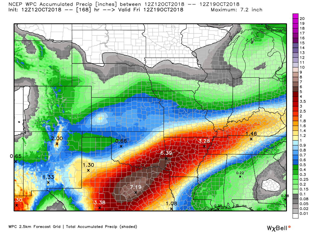
Here is the latest WPC/NOAA rainfall outlook.
Click to enlarge.
This first graphic is through Saturday morning. This covers today’s light rain event today and tonight.
.

.
.
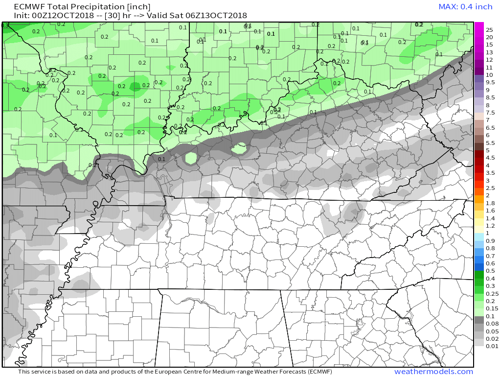
Look at the EC model guidance rain totals for today and tonight. It is a bit lower than some other models. Either way, today and tonight is a light rain event.
.
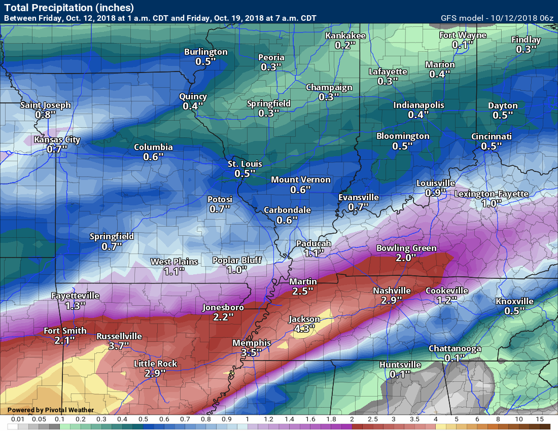
EC guidance shows the heavier totals Saturday night into Monday morning.
.

.
.
Did you know that you can find me on Twitter?

Need a forecast for an outdoor event?


We offer interactive local city live radars and regional radars.
If a radar does not update then try another one. If a radar does not appear to be refreshing then hit Ctrl F5 on your keyboard.
You may also try restarting your browser. The local city view radars also have clickable warnings.
During the winter months, you can track snow and ice by clicking the winterize button on the local city view interactive radars.

Questions? Broken links? Other questions?
You may email me at beaudodson@usawx.com

The National Weather Service defines a severe thunderstorm as one that produces quarter size hail or larger, 58 mph winds or greater, and/or a tornado.
Today through Thursday: Severe weather is not anticipated. Isolated lightning risk Saturday night into Sunday night. Risk of lightning appears to be low with little to no instability.
Interactive live weather radar page. Choose the city nearest your location. If one of the cities does not work then try a nearby one. Click here.
National map of weather watches and warnings. Click here.
Storm Prediction Center. Click here.
Weather Prediction Center. Click here.

Live lightning data: Click here.

Interactive GOES R satellite. Track clouds. Click here.

Here are the latest local river stage forecast numbers Click Here.
Here are the latest lake stage forecast numbers for Kentucky Lake and Lake Barkley Click Here.

- Light rain event
- Heavier rain event Saturday night into Monday
- Frost chances
- Cooler weather through the middle of next week
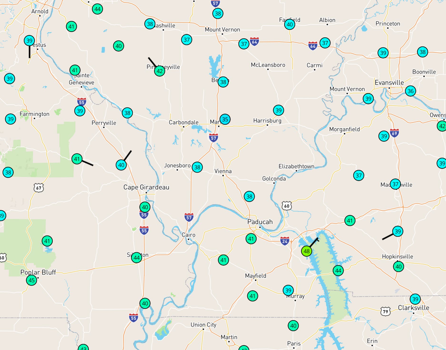
It was a chilly night across the region. There were even a few upper 30’s. A friend in Marion, Illinois reported a little light frost. Perhaps we will have autumn after all!
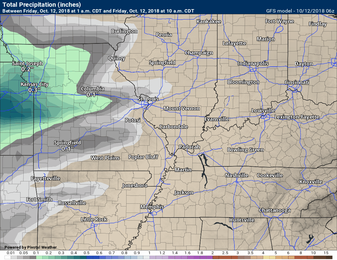
A light rain event will spread across the region today from west to east. Rainfall totals will likely remain below 0.20″.
Here is the future-cast radar from the NAM model. This is what radar might look like today into tonight.
This won’t be exact. It is a model. Take the general idea from it.
The rain will first arrive in southeast Missouri.
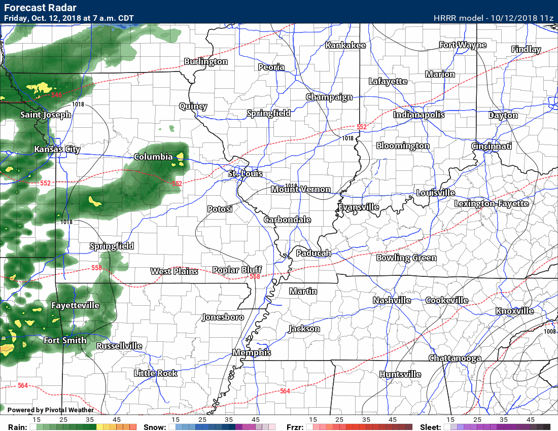
Rain showers will end tonight. At this time, it appears that clouds and winds will keep frost from being a concern. We could see temperatures dip briefly into the upper 30’s over northern portions of southeast Missouri and southern Illinois. I am more concerned about frost next week.
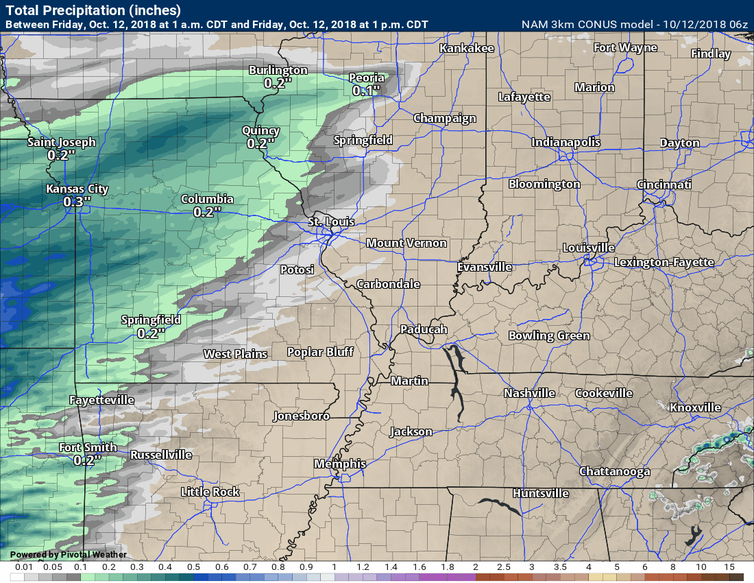
Radar totals from the NAM model. Notice wave one today and tonight. Saturday night and Sunday will deliver wave two.
These are estimated rainfall totals.
It will remain cool today with high temperatures only in the 50’s.
Saturday will likely remain dry through 4 PM. It will again be cool with high temperatures only in the 50’s. Autumn weather has certainly arrived on the scene.
Clouds will increase Saturday afternoon. This will be an indication of a stronger storm system approaching the region.
Clouds will lower and thicken Saturday night. Rain will overspread the region from southwest to northeast. Some of the rain could be moderate, at times.
Many of you have outdoor activities early Saturday night. Early evening activities should be okay. I can’t completely rule out a few showers during the evening along the Missouri and Arkansas border. Monitor updates if you have concerns.
Rain will completely overspread the region late Saturday night into Sunday afternoon. Rain showers may linger into Monday afternoon.
The model guidance does not agree about a second wave of precipitation Monday night. This is important because frost is possible Monday night if the clouds clear.
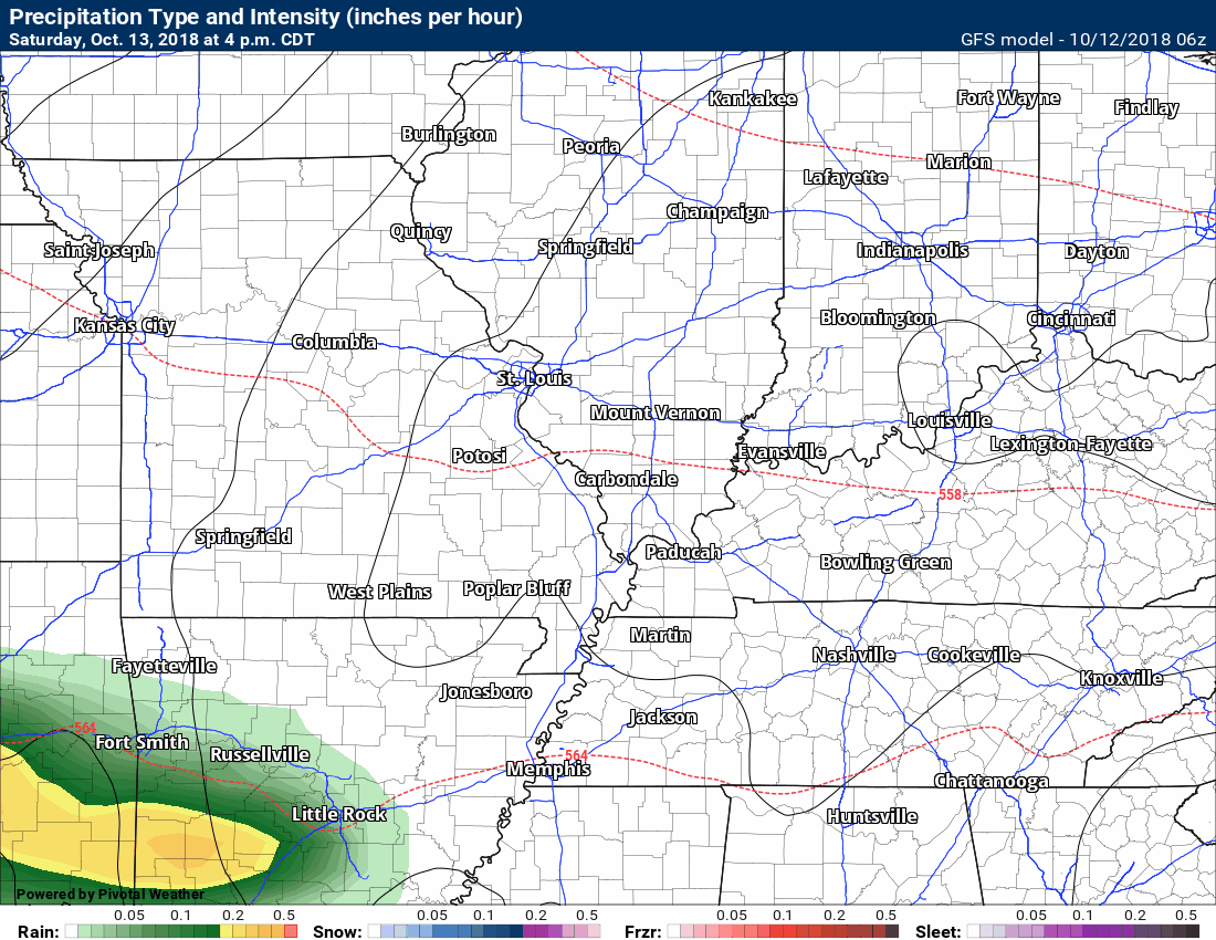
Here is the future-cast GFS radar. GFS is a lower resolution model. It tends to show a bit more precipitation coverage than verifies.
Either way, our second wave of rain arrives Saturday night (esp late) and continues on and off into Monday.
Click images on this page to enlarge.
For now, I have mentioned the possibility of frost Monday night. I also mentioned that the forecast may need adjusting. Low confidence in the Monday night forecast.
If we end up with more rain and clouds then the frost risk is reduced.
![]()
Here is the preliminary fall outlook from the long-range meteorology team.
Click to enlarge this graphic.
.
![]()
The September forecast has been updated.
![]()

I bring these to you from the BAMwx team. They are excellent long-range forecasters.
Remember, long-range outlooks are a bit of skill, understanding weather patterns, and luck combined. It is not an exact science.

This product is for subscribers.
Subscribe at www.weathertalk.com
Subscriber graphics can be viewed on this page CLICK HERE

This product is for subscribers.

Subscriber graphics can be viewed on this page CLICK HERE
![]()
.
Fall Outlook!
Preliminary October precipitation outlook
Here is the preliminary November temperature and precipitation outlook
Preliminary November temperature outlook
Preliminary November precipitation outlook
.These products are for subscribers.
![]()

A new weather podcast is now available! Weather Geeks (which you might remember is on The Weather Channel each Sunday)
To learn more visit their website. Click here.
![]()

WeatherBrains Episode 663
Joining us as our Guest WeatherBrain this week is a hydrologist in the Research Applications Lab at NCAR. He has a background in hydrology, geology and computer science. In graduate school, he found a happy marriage of these in hydrological modeling, remote sensing, and more recently atmospheric modeling. Ethan Gutmann, welcome to WeatherBrains!
Other discussions in this weekly podcast include topics like:
- Should we re-do hurricane classification?
- Ethan’s hobby of mountain climbing
- U. S. Weather Roundup
- Remnants of Hurricane Rosa entering SW United States
- Astronomy Outlook with Tony Rice
- and more!
.
.
Link to their website https://weatherbrains.com/
Previous episodes can be viewed by clicking here.

We offer interactive local city live radars and regional radars. If a radar does not update then try another one. If a radar does not appear to be refreshing then hit Ctrl F5. You may also try restarting your browser.
The local city view radars also have clickable warnings.
During the winter months, you can track snow and ice by clicking the winterize button on the local city view interactive radars.
You may email me at beaudodson@usawx.com
Find me on Facebook!

Find me on Twitter!

Did you know that a portion of your monthly subscription helps support local charity projects?
You can learn more about those projects by visiting the Shadow Angel Foundation website and the Beau Dodson News website.

I encourage subscribers to use the app vs regular text messaging. We have found text messaging to be delayed during severe weather. The app typically will receive the messages instantly. I recommend people have three to four methods of receiving their severe weather information.
Remember, my app and text alerts are hand typed and not computer generated. You are being given personal attention during significant weather events.
