Are you missing out? Want to help cover monthly operating costs?
WeatherTalk monthly operating costs can top $2000.00. Your $3 subscription helps pay for those costs. I work for you.
For $3 a month you can receive the following. You may choose to receive these via your WeatherTalk app or regular text messaging.
- Severe weather app/text alerts from my keyboard to your app/cell phone. These are hand typed by Beau. During tornado outbreaks, you will receive numerous app/text messages telling you exactly where the tornado is located.
- Daily forecast app/texts from my computer to your app/cell phone.
- Social media links sent directly to your app/cell phone. When I update the blog, videos, or Facebook you will receive the link.
- AWARE emails. These emails keep you well ahead of the storm. They give you several days of lead time before significant weather events.
- Direct access to Beau via text and email. Your very own personal meteorologist. I work for you!
- Missouri and Ohio Valley centered video updates
- Long-range weather videos
- Week one, two, three and four temperature and precipitation outlooks.
- Monthly outlooks.
- Your subscription also will help support several local charities.
Haven’t you subscribed? Subscribe at www.beaudodsonweather.com

Example of a recent severe weather alert. I issued this well before the official tornado warning. You would have had plenty of time for you and your family to seek shelter.


Your $3 per month also helps support these local charity projects.

I encourage subscribers to use the app vs regular text messaging. We have found text messaging to be delayed during severe weather. The app typically will receive the messages instantly. I recommend people have three to four methods of receiving their severe weather information.
Remember, my app and text alerts are hand typed and not computer generated. You are being given personal attention during significant weather events.


March 2, 2018
Friday Forecast Details
Forecast: Mostly sunny. Nice.
Temperatures: MO ~ 52 to 56 IL ~ 52 to 56 KY ~ 54 to 58
What is the chance of precipitation? MO ~ 0% IL ~ 0% KY ~ 0% TN ~ 0%
Coverage of precipitation: None
Winds: Northeast and north at 7 to 14 mph
What impacts are anticipated from the weather? None
My confidence in the forecast verifying: High
Is severe weather expected? No
The NWS defines severe weather as 58 mph wind or great, 1″ hail or larger, and/or tornadoes
Should I cancel my outdoor plans? No
Friday Night Forecast Details:
Forecast: Mostly clear and chilly.
Temperatures: MO ~ 28 to 34 IL ~ 28 to 34 KY ~ 30 to 34
What is the chance of precipitation? MO ~ 0% IL ~ 0% KY ~ 0% TN ~ 0%
Coverage of precipitation: None
Winds: North and northeast at 4 to 8 mph
What impacts are anticipated from the weather? None
My confidence in the forecast verifying: High
Is severe weather expected? No
The NWS defines severe weather as 58 mph wind or great, 1″ hail or larger, and/or tornadoes
Should I cancel my outdoor plans? No
March 3, 2018
Saturday Forecast Details
Forecast: Mostly sunny.
Temperatures: MO ~ 53 to 56 IL ~ 53 to 56 KY ~ 53 to 56
What is the chance of precipitation? MO ~ 0% IL ~ 0% KY ~ 0% TN ~ 0%
Coverage of precipitation: None
Winds: East at 4 to 8 mph
What impacts are anticipated from the weather? None
My confidence in the forecast verifying: High
Is severe weather expected? No
The NWS defines severe weather as 58 mph wind or great, 1″ hail or larger, and/or tornadoes
Should I cancel my outdoor plans? No
Saturday Night Forecast Details:
Forecast: Mostly clear. Chilly.
Temperatures: MO ~ 30 to 35 IL ~ 30 to 35 KY ~ 30 to 35
What is the chance of precipitation? MO ~ 0% IL ~ 0% KY ~ 0% TN ~ 0%
Coverage of precipitation: None
Winds: Southeast and east at 4 to 8 mph
What impacts are anticipated from the weather? None
My confidence in the forecast verifying: High
Is severe weather expected? No
The NWS defines severe weather as 58 mph wind or great, 1″ hail or larger, and/or tornadoes
Should I cancel my outdoor plans? No
March 4, 2018
Sunday Forecast Details
Forecast: Mostly sunny. Milder. Some increase in clouds late in the day. A 10% of a shower near Poplar Bluff after 3 PM.
Temperatures: MO ~ 56 to 60 IL ~ 56 yo 60 KY ~ 56 to 62
What is the chance of precipitation? MO ~ 10% IL ~ 0% KY ~ 0% TN ~ 0%
Coverage of precipitation: Most likely none. I will monitor southeast Missouri.
Winds: South and southeast at 6 to 12 mph
What impacts are anticipated from the weather? Wet roadways late
My confidence in the forecast verifying: High
Is severe weather expected? No
The NWS defines severe weather as 58 mph wind or great, 1″ hail or larger, and/or tornadoes
Should I cancel my outdoor plans? No
Sunday Night Forecast Details:
Forecast: Increasing clouds. A chance of showers mainly after 12 AM. Rain chances may arrive earlier over southeast Missouri. A slight chance of a thunderstorm.
Temperatures: MO ~ 40 to 45 IL ~ 40 to 45 KY ~ 40 to 45
What is the chance of precipitation? MO ~ 60% IL ~ 40% KY ~ 40% TN ~ 40%
Coverage of precipitation: Scattered late
Winds: South and southeast at 6 to 12 mph
What impacts are anticipated from the weather? Scattered wet roadways late. Slight chance of lightning.
My confidence in the forecast verifying: Medium
Is severe weather expected? No
The NWS defines severe weather as 58 mph wind or great, 1″ hail or larger, and/or tornadoes
Should I cancel my outdoor plans? No
March 5, 2018
Monday Forecast Details
Forecast: Cloudy. Scattered showers. Breezy.
Temperatures: MO ~ 54 to 58 IL ~ 54 to 58 KY ~ 54 to 58
What is the chance of precipitation? MO ~ 60% IL ~ 60% KY ~ 60% TN ~ 60%
Coverage of precipitation: Scattered
Winds: Southeast and south at 8 to 16 mph and gusty
What impacts are anticipated from the weather? Wet roadways.
My confidence in the forecast verifying: High
Is severe weather expected? No
The NWS defines severe weather as 58 mph wind or great, 1″ hail or larger, and/or tornadoes
Should I cancel my outdoor plans? Have a plan B. A few showers possible.
Monday Night Forecast Details:
Forecast: Cloudy. A chance of showers early. Rain ending. Cool.
Temperatures: MO ~ 34 to 38 IL ~ 33 to 36 KY ~ 34 to 38
What is the chance of precipitation? MO ~ 40% IL ~ 40% KY ~ 50% TN ~ 50%
Coverage of precipitation: Scattered early
Winds: West at 4 to 8 mph with gusts to 12 mph
What impacts are anticipated from the weather? Wet roadways early
My confidence in the forecast verifying: Medium
Is severe weather expected? No
The NWS defines severe weather as 58 mph wind or great, 1″ hail or larger, and/or tornadoes
Should I cancel my outdoor plans? Monitor
March 6, 2018
Tuesday Forecast Details
Forecast: Mostly sunny and breezy.
Temperatures: MO ~ 53 to 56 IL ~ 53 to 56 KY ~ 53 to 56
What is the chance of precipitation? MO ~ 0% IL ~ 0% KY ~ 0% TN ~ 0%
Coverage of precipitation: None
Winds: West at 10 to 20 mph
What impacts are anticipated from the weather? None
My confidence in the forecast verifying: Medium
Is severe weather expected? No
The NWS defines severe weather as 58 mph wind or great, 1″ hail or larger, and/or tornadoes
Should I cancel my outdoor plans? No
Tuesday Night Forecast Details:
Forecast: Mostly clear and chilly.
Temperatures: MO ~ 33 to 36 IL ~ 33 to 36 KY ~ 33 to 36
What is the chance of precipitation? MO ~ 0% IL ~ 0% KY ~ 0% TN ~ 0%
Coverage of precipitation: None
Winds: West at 6 to 12 mph with gusts to 20 mph
What impacts are anticipated from the weather? None
My confidence in the forecast verifying: Medium
Is severe weather expected? No
The NWS defines severe weather as 58 mph wind or great, 1″ hail or larger, and/or tornadoes
Should I cancel my outdoor plans? No
March 7, 2018
Wednesday Forecast Details
Forecast: Partly sunny. Cool.
Temperatures: MO ~ 43 to 46 IL ~ 43 to 46 KY ~ 42 to 46
What is the chance of precipitation? MO ~ 0% IL ~ 0% KY ~ 0% TN ~ 0%
Coverage of precipitation: None
Winds: Northwest winds at 8 to 16 mph and gusty.
What impacts are anticipated from the weather? None
My confidence in the forecast verifying: Medium
Is severe weather expected? No
The NWS defines severe weather as 58 mph wind or great, 1″ hail or larger, and/or tornadoes
Should I cancel my outdoor plans? No
Wednesday Night Forecast Details:
Forecast: Some clouds. Cold.
Temperatures: MO ~ 28 to 34 IL ~ 28 to 34 KY ~ 28 to 34
What is the chance of precipitation? MO ~ 0% IL ~ 0% KY ~ 0% TN ~ 0%
Coverage of precipitation: None
Winds: North and northwest winds at 6 to 12 mph with gusts to 16
What impacts are anticipated from the weather? None
My confidence in the forecast verifying: Medium
Is severe weather expected? No
The NWS defines severe weather as 58 mph wind or great, 1″ hail or larger, and/or tornadoes
Should I cancel my outdoor plans? No

Questions? Broken links? Other?
You may email me at beaudodson@usawx.com

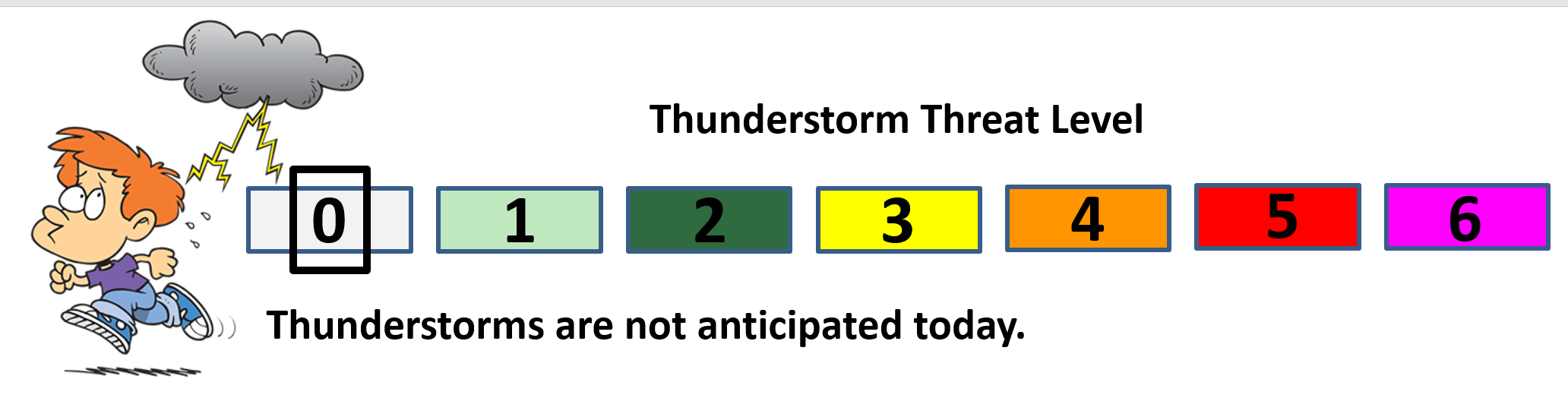
The National Weather Service defines a severe thunderstorm as one that produces quarter size hail or larger, 58 mph winds or greater, and/or a tornado.
Today and tonight: Severe weather is not anticipated.
Tomorrow through Sunday afternoon: Severe weather is not anticipated.
Sunday night into Monday: A slight chance of lightning Sunday night. Severe weather is not anticipated.
![]()
Interactive live weather radar page. Choose the city nearest your location. If one of the cities does not work then try a nearby one. Click here.
National map of weather watches and warnings. Click here.
Storm Prediction Center. Click here.
Weather Prediction Center. Click here.

Live lightning data: Click here.

Interactive GOES R satellite. Track clouds. Click here.

Here are the latest local river stage forecast numbers Click Here.
Here are the latest lake stage forecast numbers for Kentucky Lake and Lake Barkley Click Here.

The spring and preliminary summer outlooks have been posted for subscribers. Scroll down to see the outlook.
Not a subscriber? Learn more at this link.

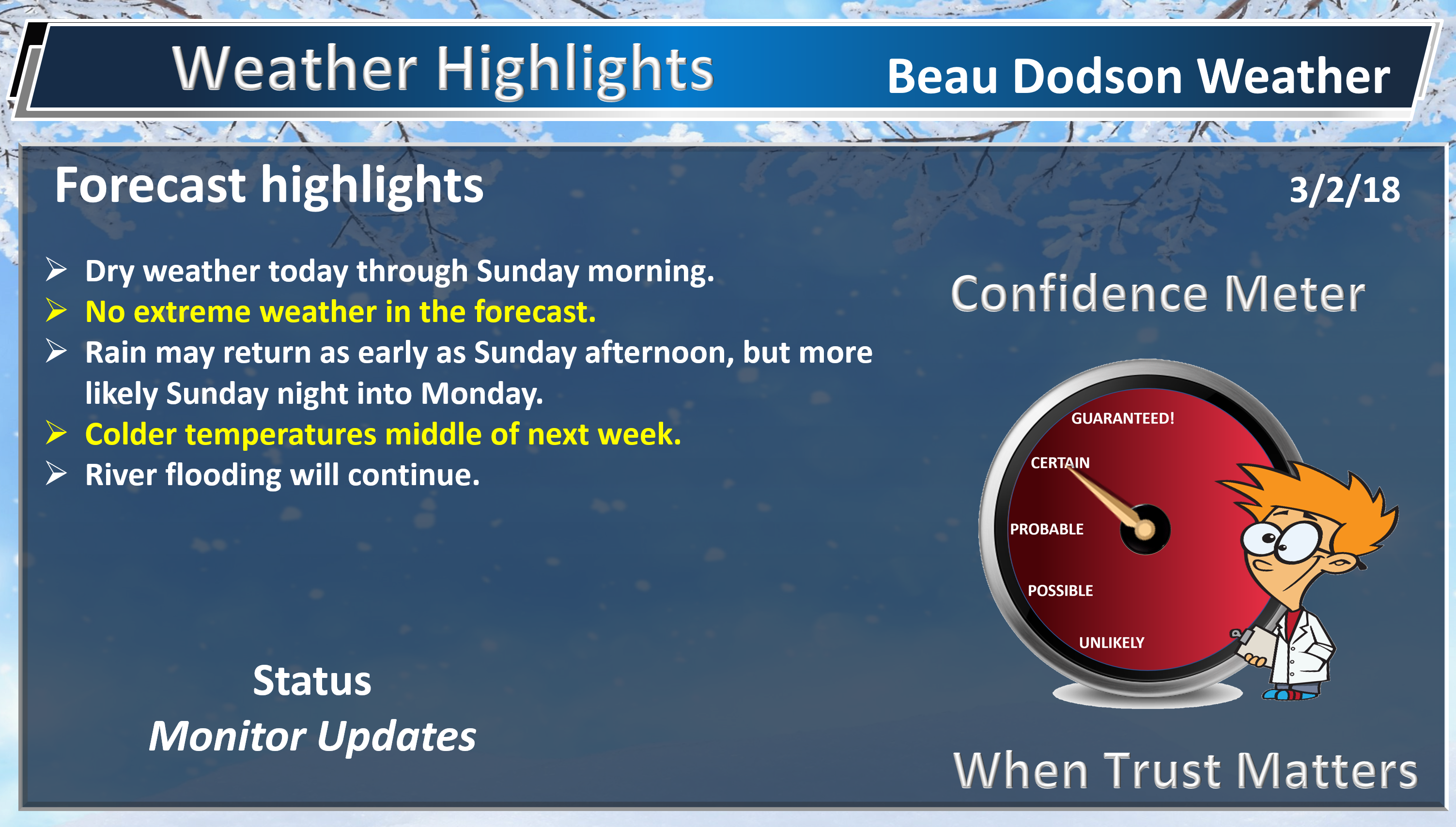
WEATHER HIGHLIGHTS
- Dry weather (finally) for a few days.
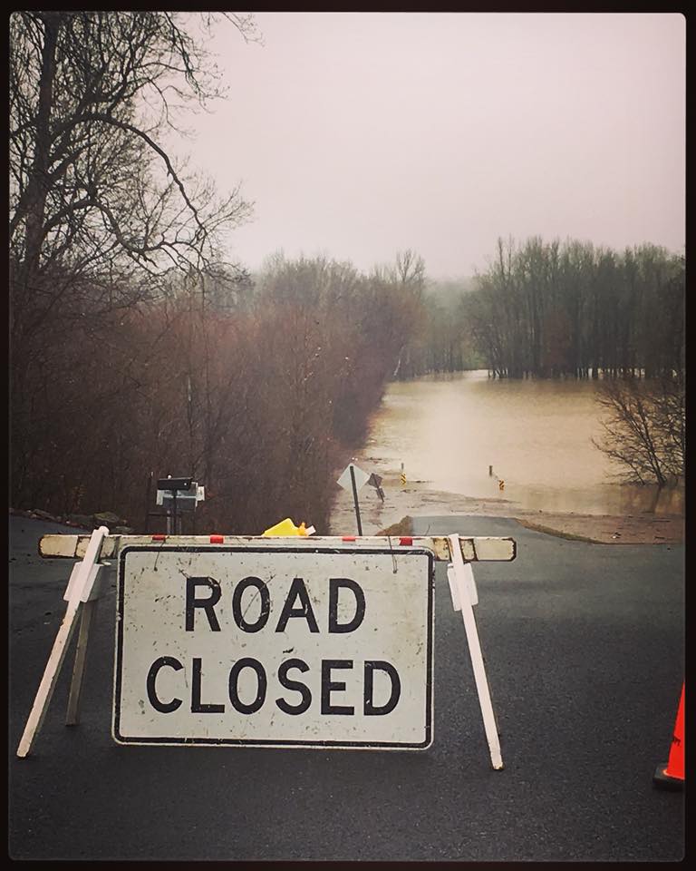
- Flooding will continue to be an issue in many areas. Avoid flooded roadways.
- Rain chances may return late Sunday afternoon or Sunday night into Monday afternoon.
- Much of next week (after Monday) could be dry. We need this.
High confidence today into Sunday afternoon.
Highlights
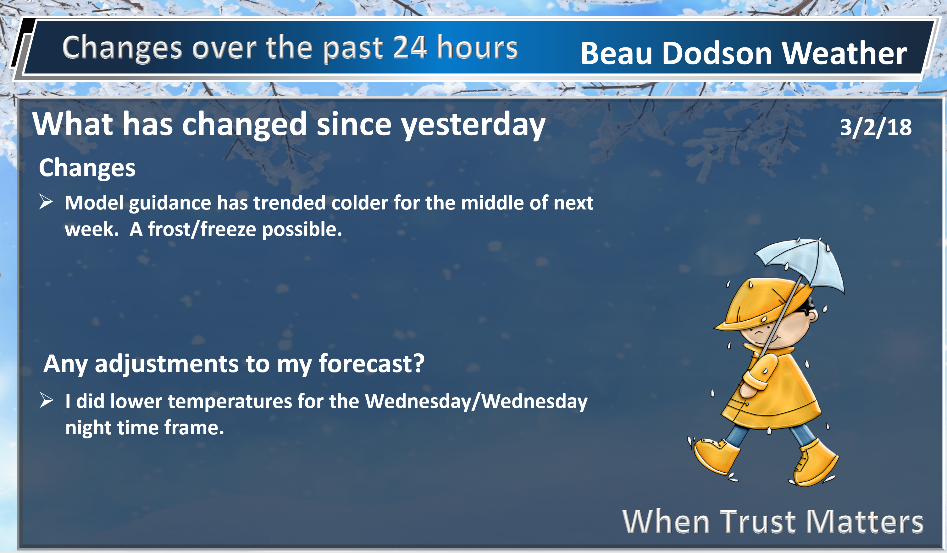
What has changed over the last 24 hours?
Weather Hazards.

We are finally going to have a short break from the rain. We need this break. Rivers are bursting from their banks. We are now looking at at least top ten river crests in many cities along the Ohio River. The Mississippi River is also flooding.
The National Weather Service, local law enforcement, and emergency management officials are urging residents to avoid flooded roadways. Do not drive around barricades. They are there for a reason.
Temperatures over the next few days will be cool to mild. No extremes in the forecast. That is good news.
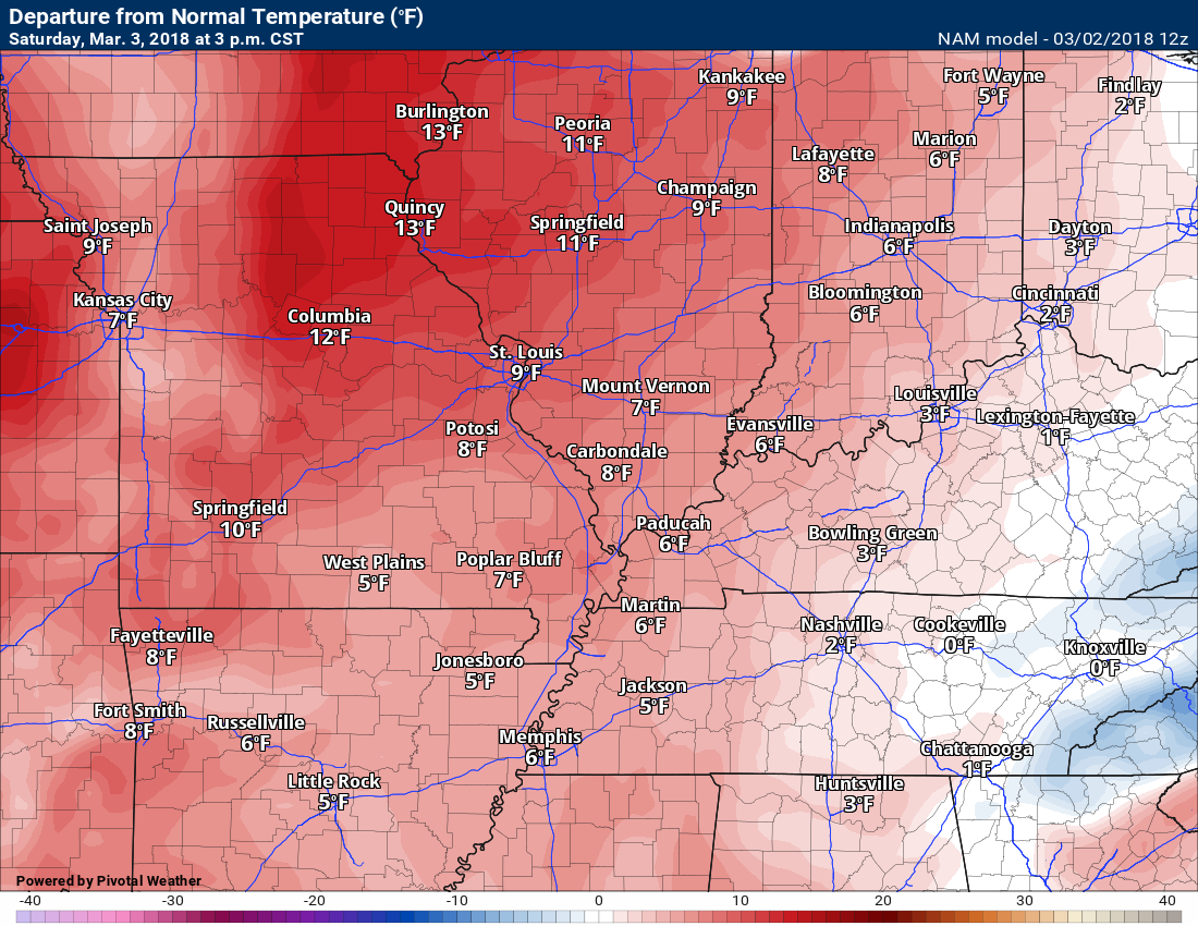
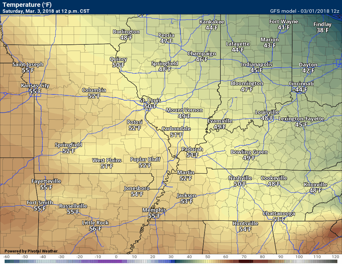
Highs today into Sunday will slowly warm y a few degrees each day. Temperatures this afternoon will top out in the middle 50’s. Saturday high temperatures will reach into the middle to perhaps upper 50’s. Sunday afternoon temperatures should peak in the upper 50’s to lower 60’s. Decent temperatures for early March.
Here is the 3 PM temperature anomaly map for this afternoon and then Saturday afternoon. We will be a few degrees above normal.
How many degrees above normal will temperatures be today?
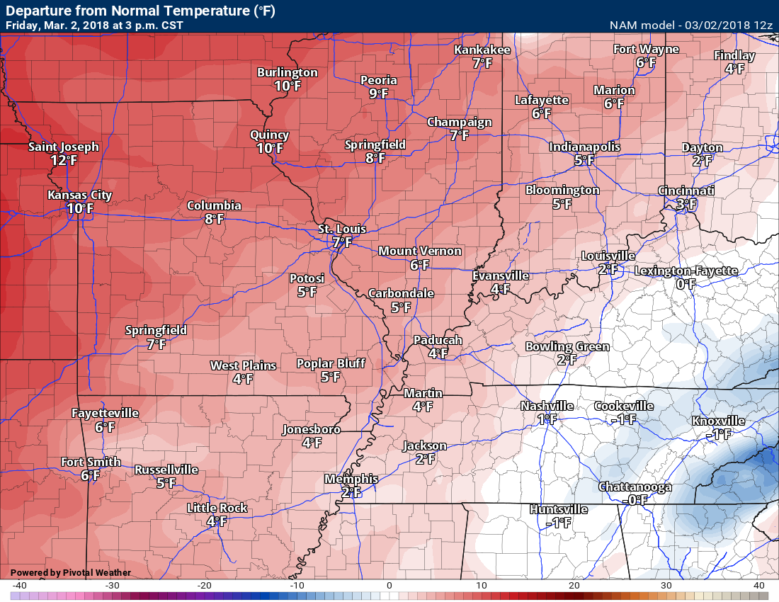
And then Saturday 3 PM
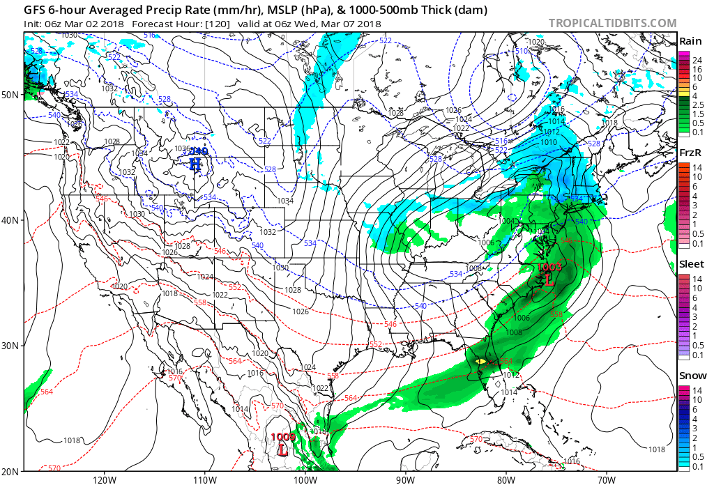
The wrinkle in the forecast will be another storm system that should arrive either Sunday afternoon or Sunday night. This system will spread rain back into our region.
The good news is that I am not forecasting severe thunderstorms. A can’t rule out a rumble of thunder. Rainfall totals should not be quite as large as recent events. I am forecasting 0.25″ to 0.45″. Monitor updates.
These rain totals will likely not impact the forecasted river crests.
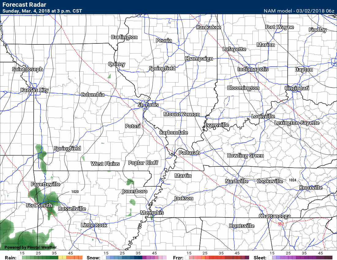
Here is the NAM model guidance future-cast radar. Keep in mind this is a model. Models are for guidance and are not gospel. This is what radar might look like as we push into Sunday afternoon and night.
Green represents rain. Dark green is moderate rain.
Timestamp upper left. This runs from Sunday 3 PM to Monday 12 PM.
Click images to enlarge.
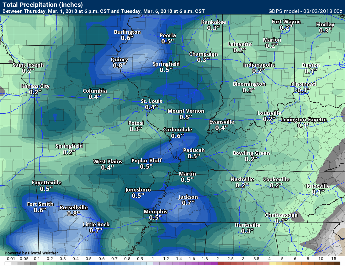
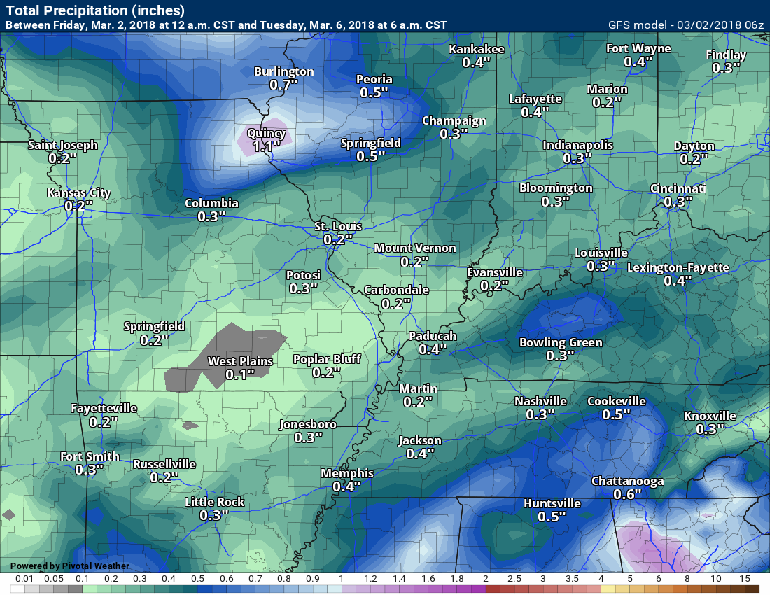
Here are some of the latest model guidance rainfall forecast numbers. These graphics show you how much each model is predicting.
The first graphic, the NAM model, cuts off at 12 PM Monday. That is why it abruptly ends the precipitation totals.
The NAM

The GFS
The Canadian model
NOAA WPC forecast

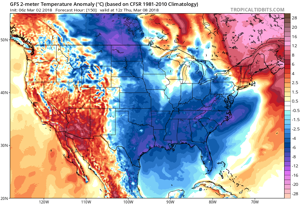
In addition to the rain, we will have to deal with colder temperatures for a portion of next week.
Here is the GFS temperature forecast. You can the cold air wrap in behind our storm system. Frost next week? Possible.
Timestamp and date located in the upper left portion of the graphic.
Click to enlarge.
The GFS model guidance shows our cold shot next week. Here are the Wednesday morning temperature anomalies.
Blue is colder than normal. Nothing extreme, but chilly. Lows in the upper 20’s to lower 30’s.
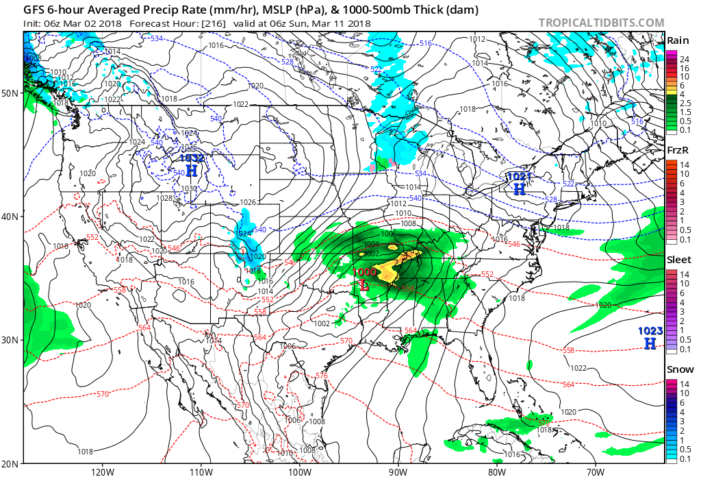
The GFS brings a weak disturbance into the region around Wednesday. It even shows snow flurries across portions of Missouri and Illinois. For now, this does not look to be a big deal (if it happens at all).
The next system to show up in the GFS model guidance is next Sunday. Long way off, so confidence in that happening is low.
The Paducah, Kentucky, and Memphis, Tennessee, National Weather Service Offices have put together a review of Saturday’s tornado event.
Hopewell Church Road in Lyon County, Kentucky. The photograph was taken by LaDonna Knoth.
Paducah, Kentucky review. Click here.
Memphis, Tennessee review. Memphis is still working on their summary page. They said they will post an update asap. Click here.
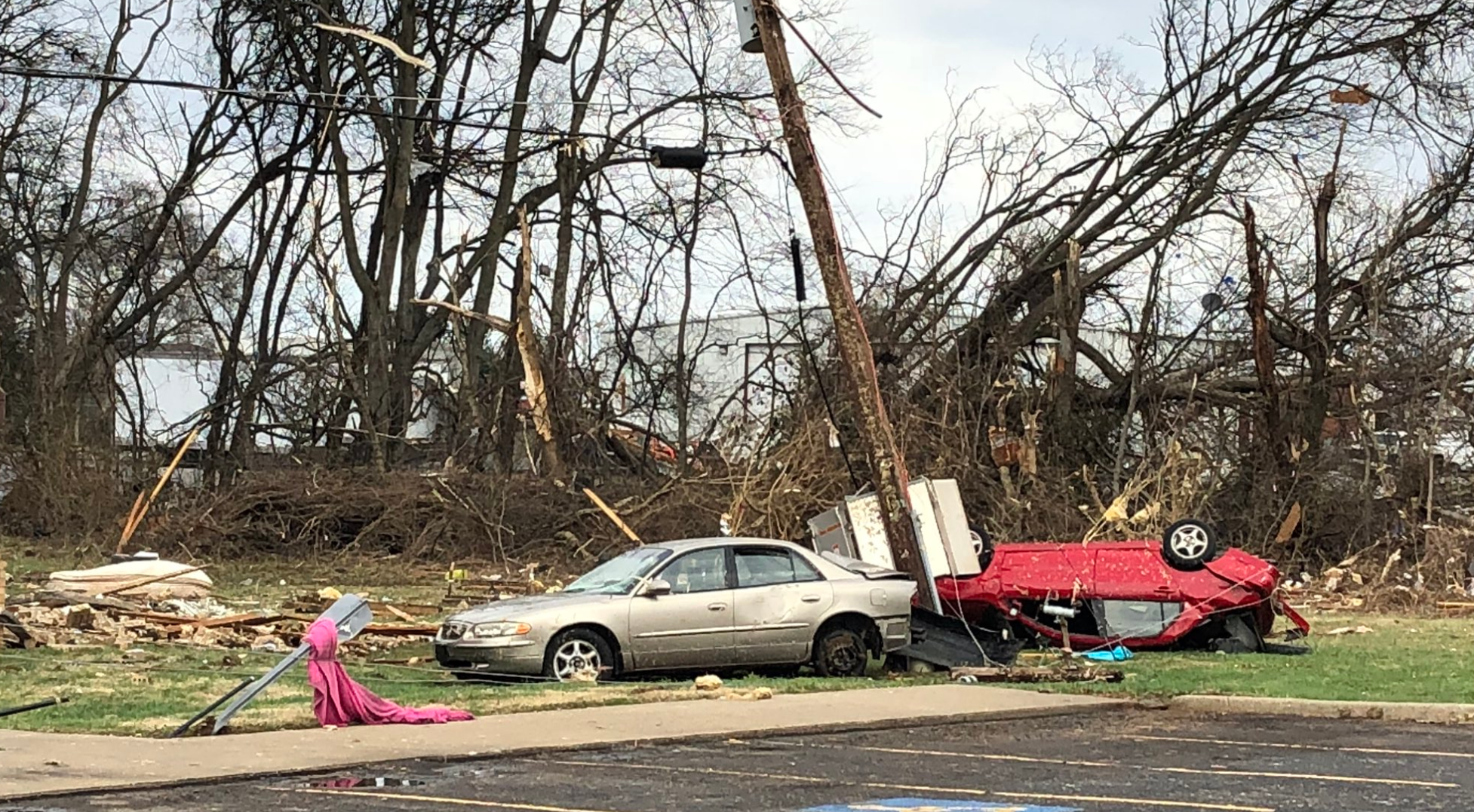
Hopkinsville, Kentucky tornado. This was Saturday. February 24, 2018. The photograph was taken by WHOP radio.
![]()
These are bonus videos and maps for subscribers.
I bring these to you from the BAMwx team. I pay them to help with videos. They have a great team of meteorologists. The Ohio and Missouri Valley videos cover most of our area. They do not have a specific Tennessee Valley forecast but may add on in the future.
The long-range video is technical. Over time, you can learn a lot about meteorology from the long range video. Just keep in mind, it is a bit more technical
.

Subscribers you may view the latest week one, two, three, and four temperature and precipitation outlooks. Videos, as well. Click here to view today’s update.
Not a subscriber? Become one! Click here.

Weather Brains is a weekly podcost/video for those who love weather and want more!
Weather Brains episode number 632.
Previous episodes can be viewed by clicking here.
Today’s guest on Weather Brains is Gregory Mandt who has overall responsibility for the JPSS Program. In this role, Mandt oversees the development, acquisition, integration, installation, and acceptance of major system elements (spacecraft, instruments, launch services, and ground systems) for all four JPSS satellites, the first of which was successfully launched in November, 2017, and the NOAA-NASA Suomi NPP satellite.
Other discussions in this weekly podcast include topics like:
- Extremes: 90 at Titusville, FL, and -12 at Gothic, CO
- First tornado deaths in US late last week
- Relatively mild across much of Lower 48
- Astronomy Outlook with Tony Rice
- and more!

We offer interactive local city live radars and regional radars. If a radar does not update then try another one. If a radar does not appear to be refreshing then hit Ctrl F5. You may also try restarting your browser.
The local city view radars also have clickable warnings.
During the winter months, you can track snow and ice by clicking the winterize button on the local city view interactive radars.
You may email me at beaudodson@usawx.com
Find me on Facebook!

Find me on Twitter!

Did you know that a portion of your monthly subscription helps support local charity projects?
You can learn more about those projects by visiting the Shadow Angel Foundation website and the Beau Dodson News website.
