
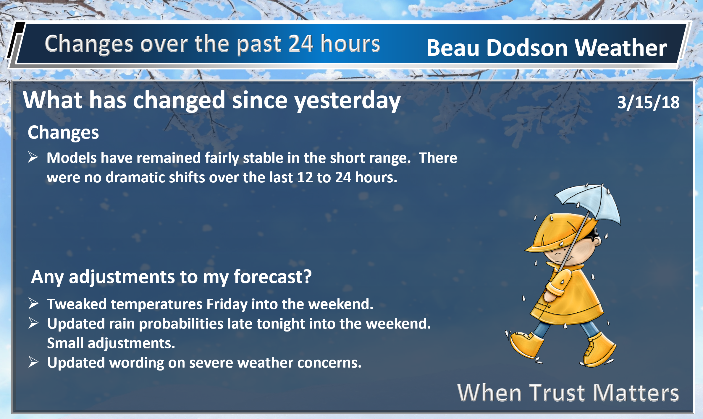
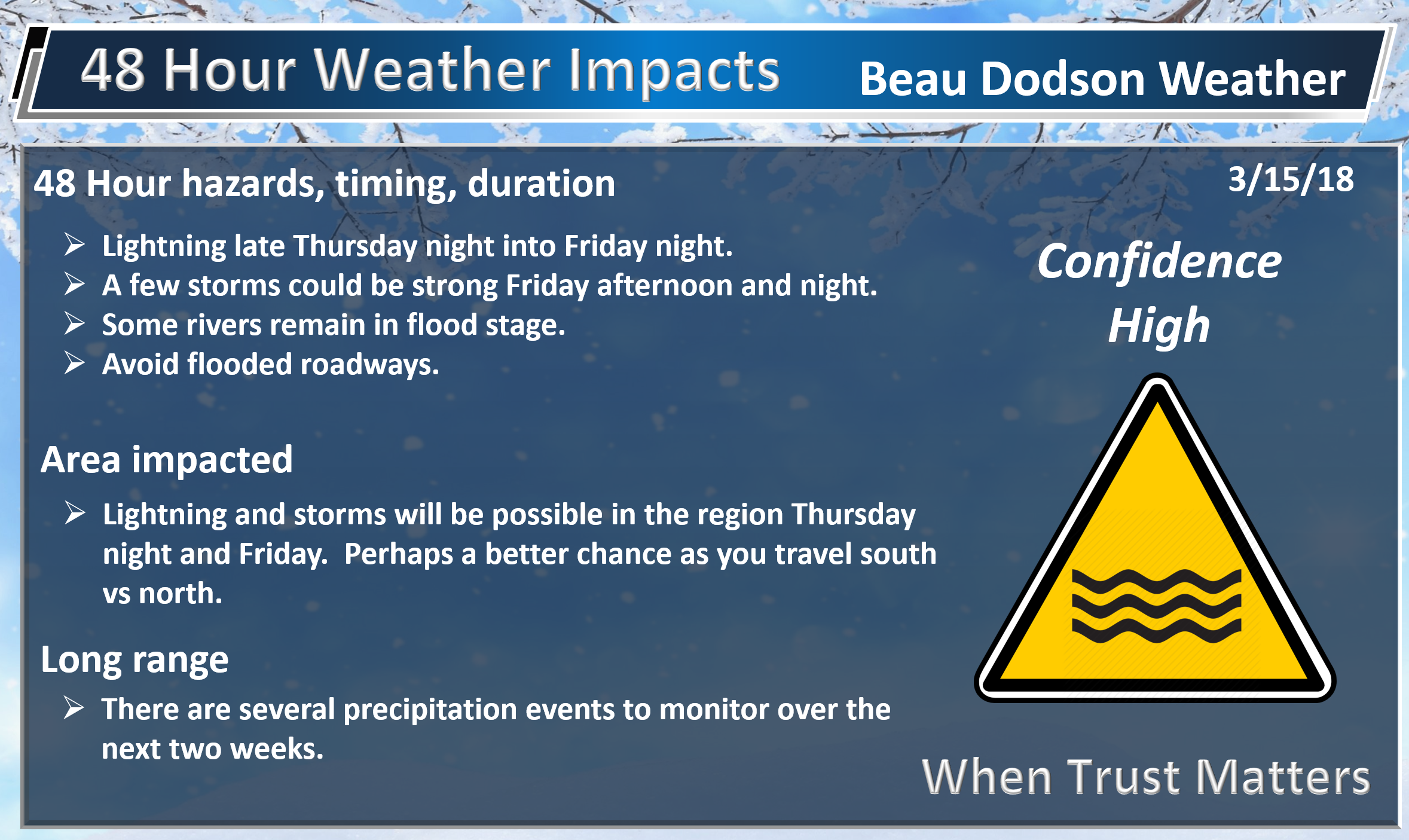
Not a lot of changes in the data.
Most of tonight will be dry. Shower chances will increase late late tonight (wee morning hours) into Friday morning.
I am monitoring the severe weather risk Friday.
The highest CAPE numbers (energy for thunderstorms) does not arrive until late Friday night and Saturday morning (before sunrise).
Just not sure about the severe weather threat.
I would not be surprised to see some strong storms. Hail and gusty winds are the primary concern.
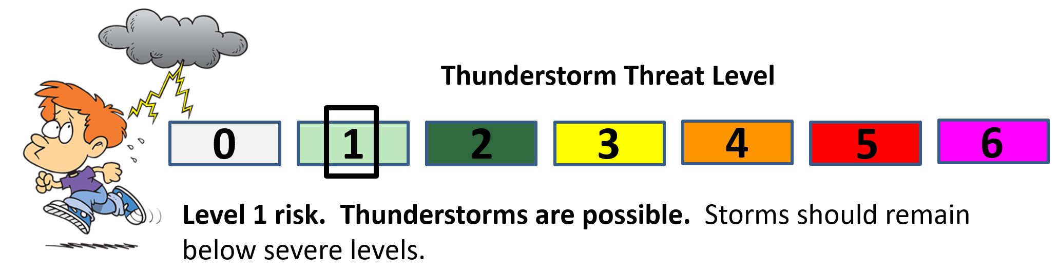
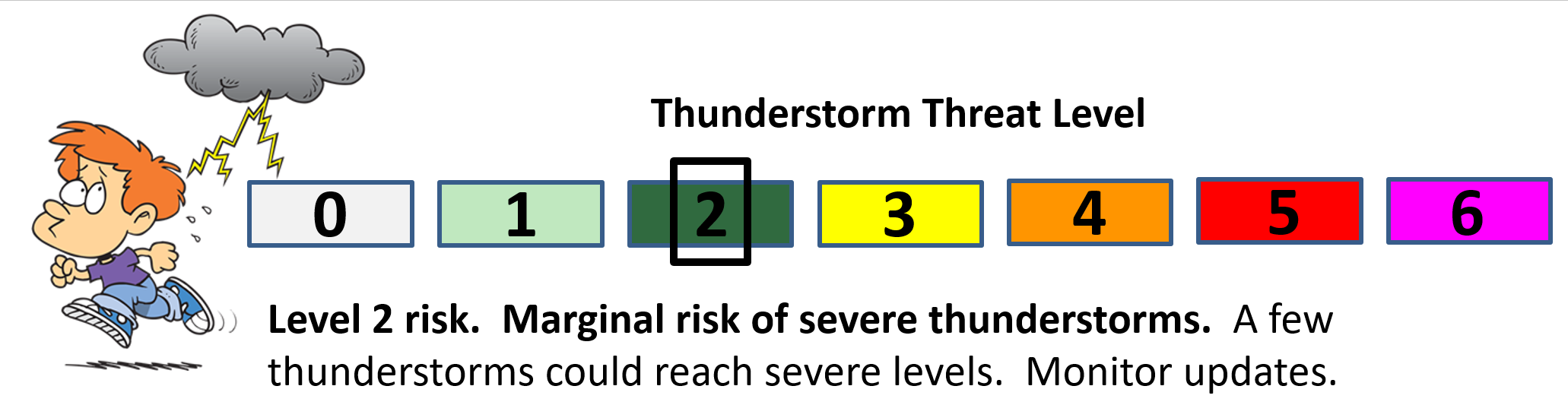
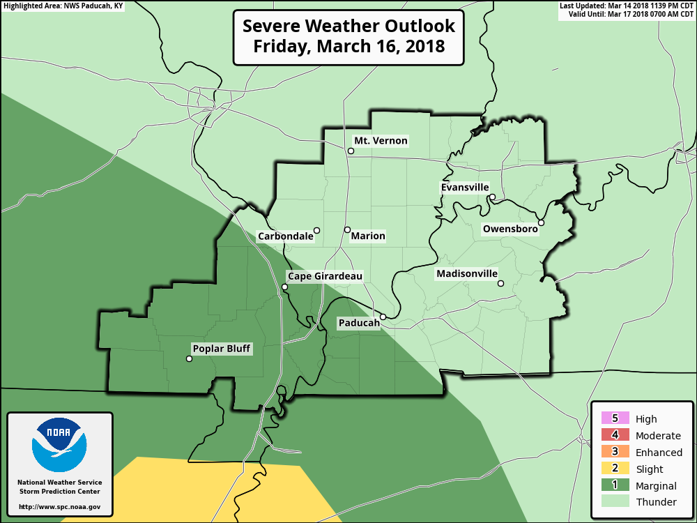
The Storm Prediction Center has outlined portions of our region in a level one and two risk. One is the lowest risk they have. Five is the higherst risk they have.
What does this graphic mean?
It means a couple of storms could produce hail and high winds. Overall, the risk is fairly low.
Light green is the zone where a few thunderstorms might occur (sub-severe)
The dark green is the level one risk.
The yellow zone is the level two risk.

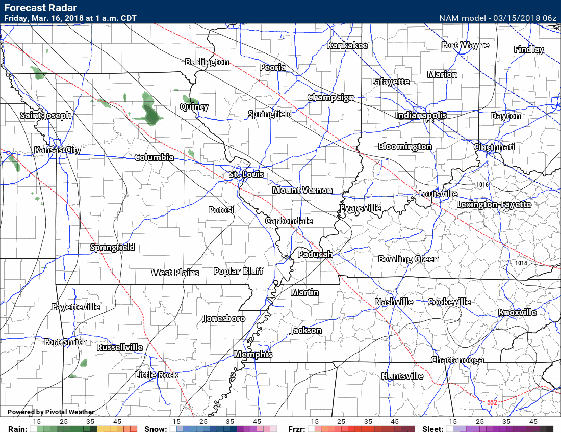
Here is the latest high-resolution NAM 3K model. This is the future-cast radar from now through tomorrow night.
Green is rain. Yellow is moderate rain. Blue is snow.
The timestamp can be found in the upper left portion of the graphic.
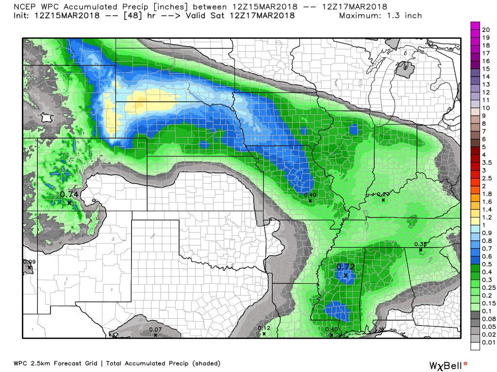
Rainfall totals tonight through Saturday morning will likely range from 0.25″ to 0.50″. Thunderstorms can always produce heavier rain totals.
Saturday will deliver dry and mild conditions. A 20% of a shower.
Dry Saturday night outside of small shower chances.
Sunday dry through mid-afternoon. I am monitoring Sunday evening for increasing shower and thunderstorm chances.
Rain and thunderstorm chances ramp up Monday into Monday night. Locally heavy downpours are a possibility.
Are you missing out? Want to help cover monthly operating costs?
WeatherTalk monthly operating costs can top $2000.00. Your $3 subscription helps pay for those costs. I work for you.
For $3 a month you can receive the following. You may choose to receive these via your WeatherTalk app or regular text messaging.
- Severe weather app/text alerts from my keyboard to your app/cell phone. These are hand typed by Beau. During tornado outbreaks, you will receive numerous app/text messages telling you exactly where the tornado is located.
- Daily forecast app/texts from my computer to your app/cell phone.
- Social media links sent directly to your app/cell phone. When I update the blog, videos, or Facebook you will receive the link.
- AWARE emails. These emails keep you well ahead of the storm. They give you several days of lead time before significant weather events.
- Direct access to Beau via text and email. Your very own personal meteorologist. I work for you!
- Missouri and Ohio Valley centered video updates
- Long-range weather videos
- Week one, two, three and four temperature and precipitation outlooks.
- Monthly outlooks.
- Your subscription also will help support several local charities.
Haven’t you subscribed? Subscribe at www.beaudodsonweather.com

Example of a recent severe weather alert. I issued this well before the official tornado warning. You would have had plenty of time for you and your family to seek shelter.


Your $3 per month also helps support these local charity projects.

I encourage subscribers to use the app vs regular text messaging. We have found text messaging to be delayed during severe weather. The app typically will receive the messages instantly. I recommend people have three to four methods of receiving their severe weather information.
Remember, my app and text alerts are hand typed and not computer generated. You are being given personal attention during significant weather events.


March 15, 2018
Thursday Forecast Details
Forecast: Mostly sunny. Milder. A nice day to be outside. Breezy, at times. Spring-like weather.
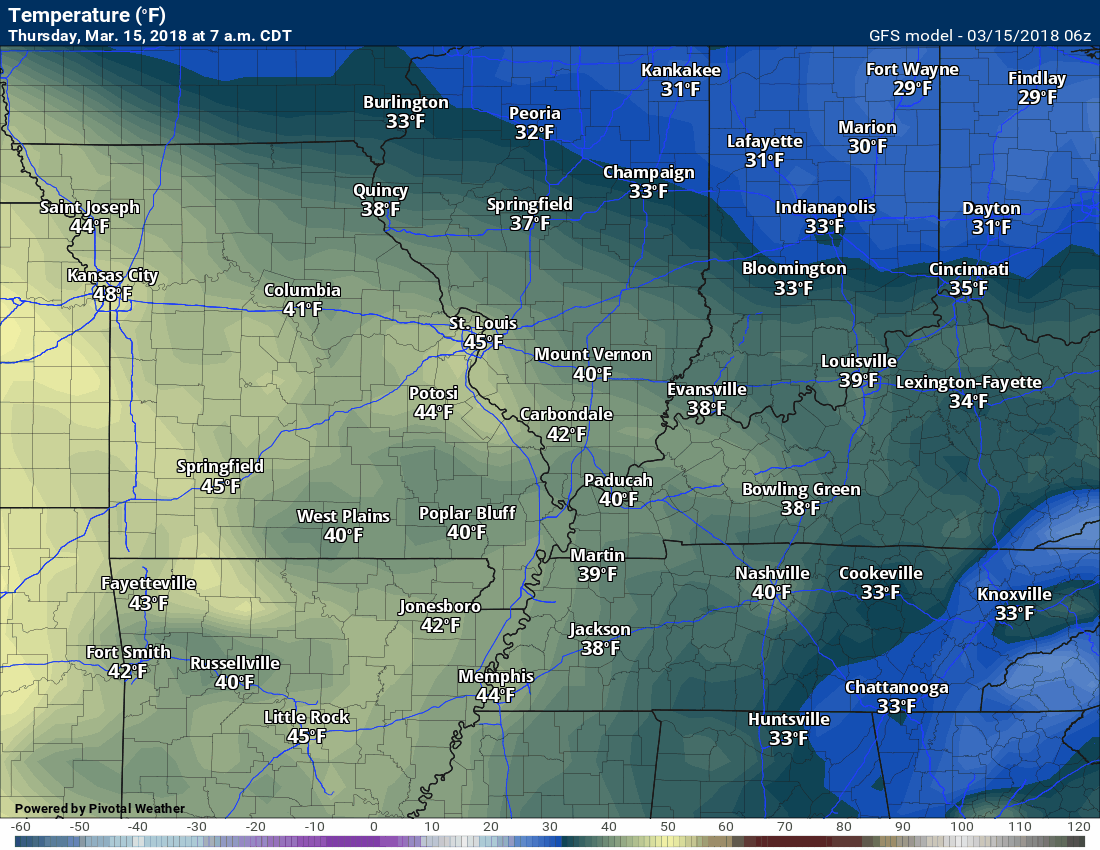
Temperatures: MO ~ 65 to 70 IL ~ 60 to 68 (cooler Mt Vernon vs Metropolis) KY ~ 64 to 68 TN ~ 64 to 68
What is the chance of precipitation? MO ~ 0% IL ~ 0% KY ~ 0% TN ~ 0%
Coverage of precipitation: None
Winds: West and southwest 7 to 14 mph. Gusty winds likely during the afternoon as the pressure gradient tightens.
What impacts are anticipated from the weather? None
My confidence in the forecast verifying: High
Is severe weather expected? No
The NWS defines severe weather as 58 mph wind or great, 1″ hail or larger, and/or tornadoes
Should I cancel my outdoor plans? No
Sunrise 7:05 AM
Thursday Night Forecast Details:
Forecast: Mostly clear early. Increasing clouds through the night. Showers developing from the west and southwest after 3 AM (mostly over southeast Missouri). A rumble of thunder possible late (mostly over southeast Missouri).
Temperatures: MO ~ 44 to 48 IL ~ 38 to 44 (Colder near Mt Vernon vs Metropolis) KY ~ 38 to 45 (colder towards Evansville vs Paducah) TN ~ 43 to 46
What is the chance of precipitation? MO ~ 40% IL ~ 30% KY ~ 30% TN ~ 30%
Coverage of precipitation: None early. Becoming scattered after 3 AM.
Winds: South and southwest at 5 to 10 mph with gusts to 12 mph. Winds may become more south and southeast.
What impacts are anticipated from the weather? Wet roadways. Perhaps lightning late.
My confidence in the forecast verifying: High
Is severe weather expected? No
The NWS defines severe weather as 58 mph wind or great, 1″ hail or larger, and/or tornadoes
Should I cancel my outdoor plans? No
Sunset 7:01 PM
March 16, 2018
Friday Forecast Details
Forecast: Mostly cloudy. Rain developing. Thunderstorms possible. A few strong storms possible during the afternoon hours. Cooler north of the warm front. Warmer south of the warm front.
Temperatures: MO ~ 55 to 60 IL ~ 45 to 55 (cooler near Mt Vernon vs Metropolis) KY ~ 52 to 58 TN ~ 56 to 62
What is the chance of precipitation? MO ~ 70% IL ~ 70% KY ~ 70% TN ~ 70%
Coverage of precipitation: Widespread
Winds: East and southeast 7 to 14 mph with gusts to 25 mph
What impacts are anticipated from the weather? Wet roadways. Perhaps lightning.
My confidence in the forecast verifying: High on the rain and medium on temperatures
Is severe weather expected? I can’t rule out a few strong thunderstorms with hail and strong winds late in the day or evening. . The most likely area would be southeast Missouri into western Kentucky and western Tennessee.
The NWS defines severe weather as 58 mph wind or great, 1″ hail or larger, and/or tornadoes
Should I cancel my outdoor plans? Have a plan B and monitor updates.
Sunrise 7:03 AM
Friday Night Forecast Details:
Forecast: Cloudy. Showers likely. A chance of a thunderstorm. Temperatures will vary based on the location of the warm front.
Temperatures: MO ~ 44 to 48 IL ~ 40 to 50 Cooler in Mt Vernon vs Metropolis KY ~ 42 to 50 Cooler Evansville vs Paducah TN ~ 48 to 54
What is the chance of precipitation? MO ~ 60% IL ~ 60% KY ~ 60% TN ~ 60%
Coverage of precipitation: Numerous
Winds: East and southeast at 8 to 16 mph with gusts to 22 mph
What impacts are anticipated from the weather? Wet roadways. Lightning.
My confidence in the forecast verifying: Medium.
Is severe weather expected? Monitor updates. A few strong thunderstorms are possible. Gusty wind and hail would be the primary concern. The severe weather risk will need to be monitored.
The NWS defines severe weather as 58 mph wind or great, 1″ hail or larger, and/or tornadoes
Should I cancel my outdoor plans? Have a plan B and monitor updates.
Sunset 7:02 PM
March 17, 2018
Saturday Forecast Details
Forecast: A mix of sun and clouds. Clearing possible. Warmer. A slight chance of a shower.
Temperatures: MO ~ 56 to 66 IL ~ 56 to 65 Cooler Mt Vernon vs Metropolis KY ~ 56 to 65 Cooler Evansville vs Paducah TN ~ 65 to 70
What is the chance of precipitation? MO ~ 20% IL ~ 20% KY ~ 20% TN ~ 20%
Coverage of precipitation: None to isolated
Winds: Variable at 6 to 12 mph with gusts to 20 mph
What impacts are anticipated from the weather? None to perhaps some wet roadways.
My confidence in the forecast verifying: Medium
Is severe weather expected? No
The NWS defines severe weather as 58 mph wind or great, 1″ hail or larger, and/or tornadoes
Should I cancel my outdoor plans? No
Sunrise 7:02 AM
Saturday Night Forecast Details:
Forecast: Mostly cloudy. An isolated shower.
Temperatures: MO ~ 45 to 50 IL ~ 40 to 50 KY ~ 45 to 50 TN ~ 46 to 52
What is the chance of precipitation? MO ~ 20% IL ~ 20% KY ~ 20% TN ~ 20%
Coverage of precipitation: Isolated
Winds: North at 4 to 8 mph with gusts to 10 mph
What impacts are anticipated from the weather? None to wet roadways.
My confidence in the forecast verifying: Medium
Is severe weather expected? No
The NWS defines severe weather as 58 mph wind or great, 1″ hail or larger, and/or tornadoes
Should I cancel my outdoor plans? No
Sunset 7:03 PM
March 18, 2018
Sunday Forecast Details
Forecast: Partly sunny and warmer. A shower possible in the Missouri Bootheel.
Temperatures: MO ~ 60 to 64 IL ~ 58 to 64 KY ~ 58 to 64 TN ~ 63 to 66
What is the chance of precipitation? MO ~ 30% IL ~ 20% KY ~ 20% TN ~ 20%
Coverage of precipitation: None to isolated
Winds: North and northeast at 6 to 12 mph
What impacts are anticipated from the weather? Perhaps a few wet roads.
My confidence in the forecast verifying: LOW
Is severe weather expected? No
The NWS defines severe weather as 58 mph wind or great, 1″ hail or larger, and/or tornadoes
Should I cancel my outdoor plans? No
Sunrise 7:00 AM
Sunday Night Forecast Details:
Forecast: Cloudy. A chance of showers and thunderstorms.
Temperatures: MO ~ 45 to 50 IL ~ 44 to 48 KY ~ 42 to 46 TN ~ 46 to 52
What is the chance of precipitation? MO ~ 60% IL ~ 40% KY ~ 40% TN ~ 40%
Coverage of precipitation: Scattered
Winds: East and southeast at 5 to 10 mph
What impacts are anticipated from the weather? Wet roadways. Lightning.
My confidence in the forecast verifying: LOW
Is severe weather expected? Unlikely
The NWS defines severe weather as 58 mph wind or great, 1″ hail or larger, and/or tornadoes
Should I cancel my outdoor plans? Monitor updates.
Sunset 7:04 PM
March 19, 2018
Monday Forecast Details
Forecast: Mostly cloudy. Showers and thunderstorms likely. A few storms could produce heavy downpours. Monitor updates.
Temperatures: MO ~ 60 to 66 IL ~ 56 to 64 Cooler Mt Vernon vs Metropolis KY ~ 62 to 66 TN ~ 64 to 68
What is the chance of precipitation? MO ~ 70% IL ~ 70% KY ~ 70% TN ~ 70%
Coverage of precipitation: Perhaps widespread
Winds: South at 10 to 20 mph and gusty.
What impacts are anticipated from the weather? Wet roadways. Lightning. Monitor the potential of strong thunderstorms.
My confidence in the forecast verifying: Medium
Is severe weather expected? Monitor updates
The NWS defines severe weather as 58 mph wind or great, 1″ hail or larger, and/or tornadoes
Should I cancel my outdoor plans? Have a plan B
Sunrise 6:59 AM
Monday Night Forecast Details:
Forecast: Cloudy. Some question about the timing of the rains departure Monday night/Tuesday morning. A chance of showers and thunderstorms. Most of the rain should end before 2 AM Tuesday. Turning cooler.
Temperatures: MO ~ 36 to 42 IL ~ 36 to 42 KY ~ 38 to 42 TN ~ 40 to 42
What is the chance of precipitation? MO ~ 60% IL ~ 60% KY ~ 60% TN ~ 60%
Coverage of precipitation: Perhaps widespread
Winds: West and northwest at 6 to 12 mph and gusty.
What impacts are anticipated from the weather? Wet roadways. Lightning.
My confidence in the forecast verifying: LOW
Is severe weather expected? Monitor updates
The NWS defines severe weather as 58 mph wind or great, 1″ hail or larger, and/or tornadoes
Should I cancel my outdoor plans? Have a plan B.
Sunset 7:05 PM

Questions? Broken links? Other?
You may email me at beaudodson@usawx.com

The National Weather Service defines a severe thunderstorm as one that produces quarter size hail or larger, 58 mph winds or greater, and/or a tornado.
Today and tonight: Severe weather is not anticipated. Isolated lightning possible after 4 AM. This would be over southeast Missouri.
Tomorrow through tomorrow night: A few storms could produce hail and gusty winds late Friday afternoon and night. There is some question about the placement of a warm front and dew points. Lower dew points would lessen the severe weather risk. Higher dew points would provide more moisture and lift. Monitor updates. The tornado risk is low, but not zero. The greatest risk would be along the Missouri and Arkansas border and then into west Kentucky and western Tennessee.
Overall, the risk appears to be fairly low.
The Storm Prediction Center has placed our region in a marginal risk Friday afternoon and night. Monitor updates.
Saturday through Sunday: Saturday will likely end up mostly dry. Severe weather is not anticipated Saturday through Sunday afternoon.
Sunday night through Monday night:
Some thunderstorms are possible Sunday night into Monday night. Severe thunderstorms can’t be ruled out. Monitor updates.
![]()
Interactive live weather radar page. Choose the city nearest your location. If one of the cities does not work then try a nearby one. Click here.
National map of weather watches and warnings. Click here.
Storm Prediction Center. Click here.
Weather Prediction Center. Click here.

Live lightning data: Click here.

Interactive GOES R satellite. Track clouds. Click here.

Here are the latest local river stage forecast numbers Click Here.
Here are the latest lake stage forecast numbers for Kentucky Lake and Lake Barkley Click Here.

The spring and preliminary summer outlooks have been posted for subscribers. Scroll down to see the outlook.
Not a subscriber? Learn more at this link.

- WEATHER HIGHLIGHTS
- Warm today! Get out and enjoy it.
- Rain chances increase late Thursday night into Friday night.
- Saturday and Sunday will be mostly dry (outside of isolated showers).
- Rain chances ramp up Sunday night into Monday night.
- Flooding will continue to be an issue in some areas. Avoid flooded roadways.
- In case you missed it! Here is the Facebook thread with some exciting new announcements concerning Weather Talk. Click here to read that.
Highlights

What has changed over the last 24 hours?
Weather Hazards.
Today is going to be nice! If you can make it outside then please do so. Temperatures will rise into the 60’s! It will feel like spring today. Plenty of sunshine, as well. There could be a few more clouds as we move into this afternoon, but still nice.
The bulk of tonight will be dry.
Rain chances will increase towards morning across southeast Missouri. The rain will then spread east and northeast across our region Friday.
Widespread showers and thunderstorms are anticipated Friday and Friday night.
A few of the thunderstorms could produce hail and strong winds.
There are some questions about thunderstorm intensity.
The system may occlude as it moves into the Missouri Valley. If it occludes then that would prevent the higher dew points from streaming northward. Those higher dew points are key to the severe weather threat.
Monitor updates Friday and Friday night.
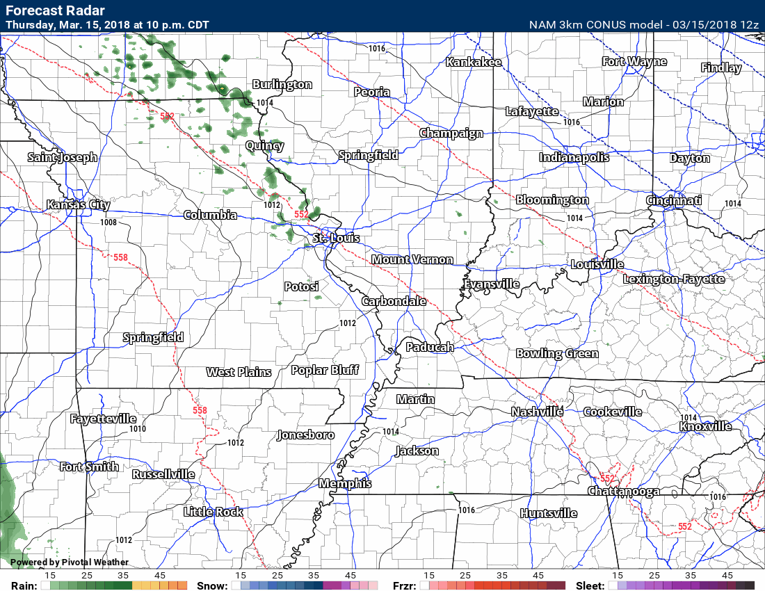
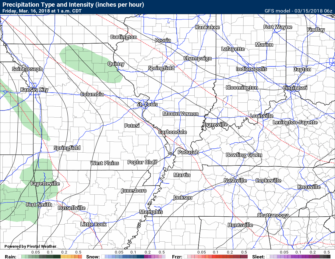
Here is the future-cast radar from the NAM model guidance. This what radar might look like.
This takes us through 10 AM Saturday. You can see bands of rain moving through the region late tonight into tomorrow night.
The timestamp is located in the upper left.
Green is rain. Yellow is heavier rain. Blue is snow. Purple and red are a wintry mix.
The Storm Prediction Center has outlined a risk of general thunderstorms to our west today. The light green zone is where thunderstorms are possible but likely below severe levels.
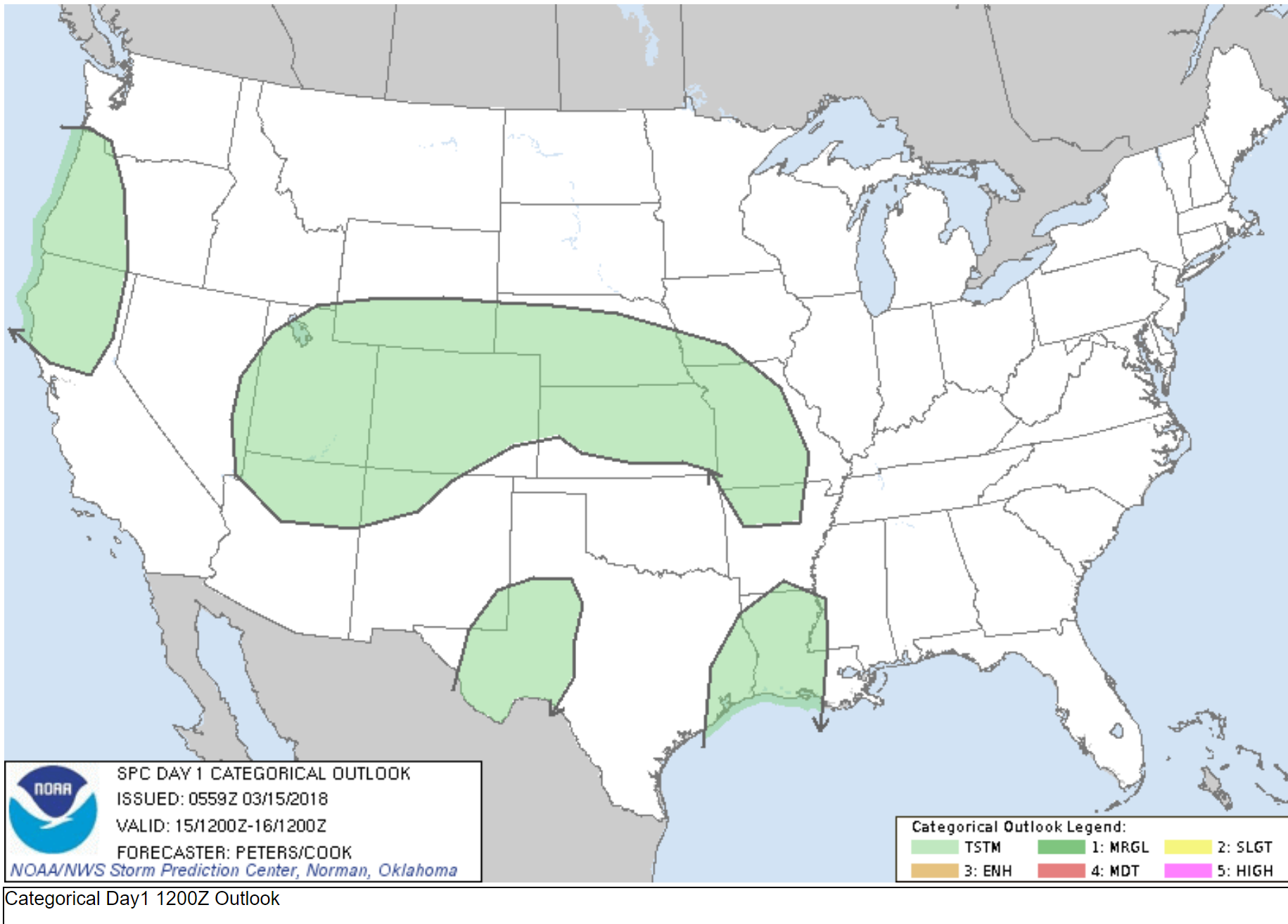
The SPC has outlined a risk of severe thunderstorms Friday and Friday night for portions of the region. You can see that depicted in the graphic below.
We have been watching this system for about two or three weeks.
The light green outline represents where lightning is possible. Storms are not anticipated to be severe in that zone. A few reports of gusty winds and small hail possible.
The dark green area is where some thunderstorms could produce large hail and damaging winds.
The yellow zone is where the Storm Prediction Center believes the greatest risk of severe thunderstorms will be located.
Monitor updates. These outlooks often shift around as new data becomes available.
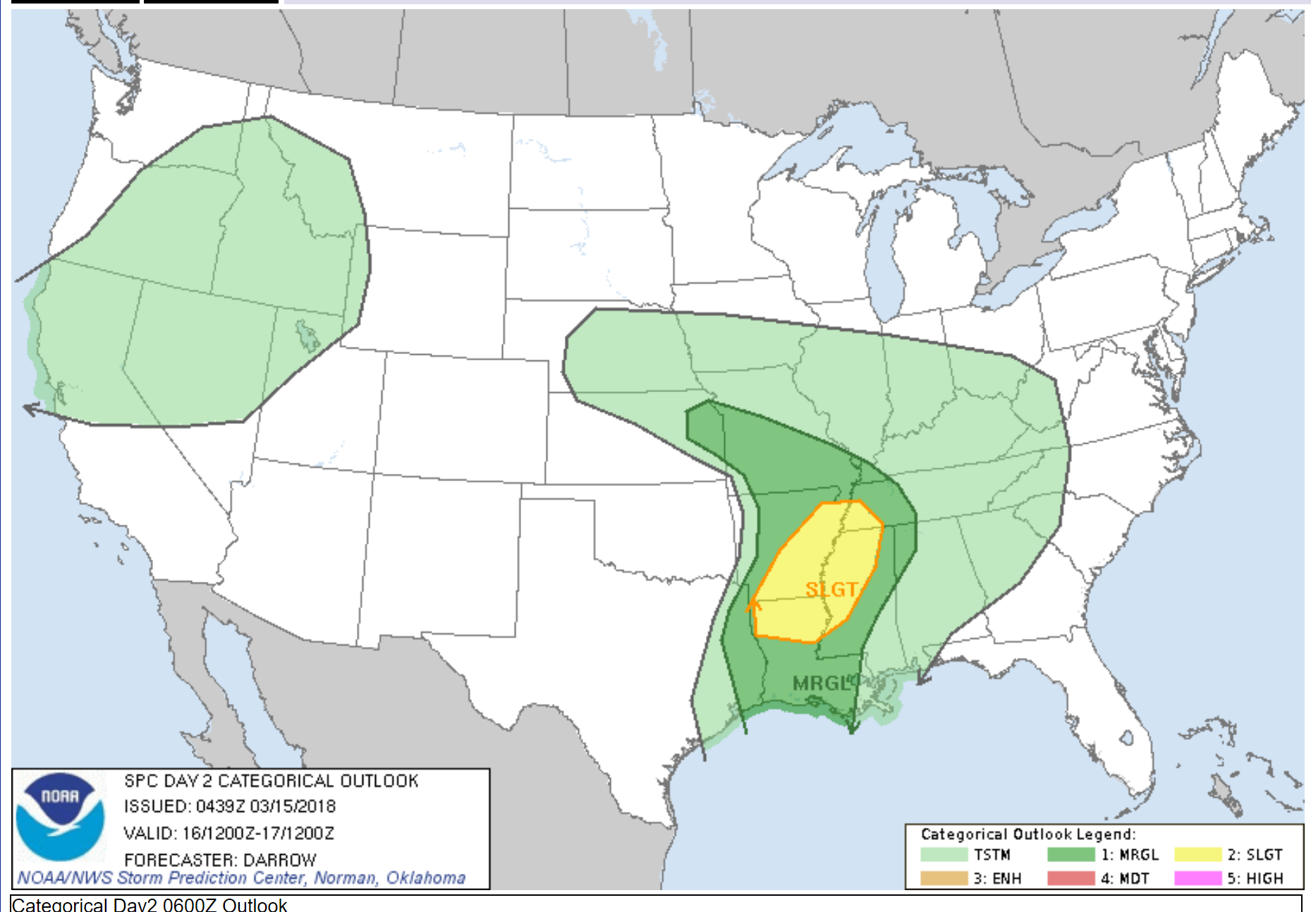
Here is a zoomed view of the Friday and Friday night severe weather outlook.
Again, the dark green area is a marginal risk. A level one out of five risk. One being the lowest risk and five being the highest risk.
The yellow zone is a level two risk. I will keep an eye on this. The outlook may need adjusting as fresh data becomes available.
Dew points will be on the rise Friday afternoon into Friday night/Saturday morning.
Typically, I look for dewpoints of 58 degrees and above in order to consider forecasting severe weather. Higher dew points equal higher severe weather risks.
The dew points will struggle to reach 60 degrees. This raises questions about whether severe weather will be a concern.
Again, monitor updates.
Here is the high-resolution 3K NAM guidance. This is the dew point animation from today through Friday night. You can see how dry the air is early on. As our system pulls into the region Friday and Friday night it will pull higher dew points further north.

Rainfall totals Thursday night (late) into Saturday will likely range from 0.20″ to 0.50″. Locally higher totals are possible.
Here is the latest NOAA rainfall outlook. This takes us through Saturday 7 AM.
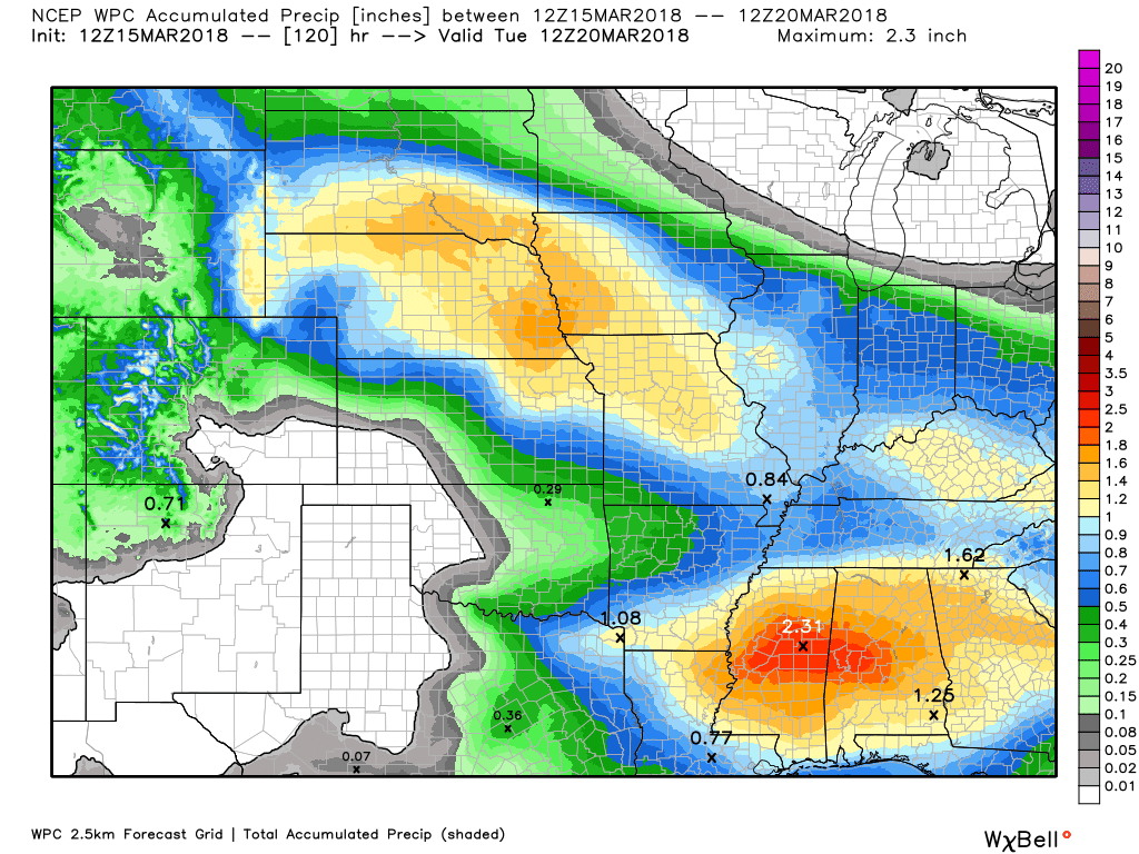
This next graphic shows you the rain totals from Thursday night through Tuesday morning. This is not in addition to the above. This is showing you the precipitation totals from Thursday night through Tuesday.
Rain totals from Thursday night through Tuesday should range from 0.60″ to 1″00. Locally higher totals possible.
Thunderstorms can always produce higher rain totals. Keep that in mind.
Here is the future-cast radar from the GFS model guidance. Keep in mind, this is a model and not gospel. It won’t be exact. Just take the general idea from this graphic that some rain will be possible late Thursday night into Friday night.
This first animation is for Thursday night into Saturday evening.
You can see the rain showers and thunderstorms move into the region late Thursday night and Friday. There is a lull in the precipitation Saturday morning and afternoon. I can’t rule out isolated showers.
Timestamp upper left
Saturday and Sunday
Your outdoor plans Saturday and Sunday should be safe from rain. Isolated showers possible, but nothing to worry about.
High temperatures both Saturday and Sunday should be in the upper 50’s to middle 60’s. We will take it!
Check out the temperature roller-coaster over the coming week.
The timestamp is located in the upper left portion of the graphic.
Sunday night through Tuesday.
Rain chances ramp up again Sunday night into Monday night.
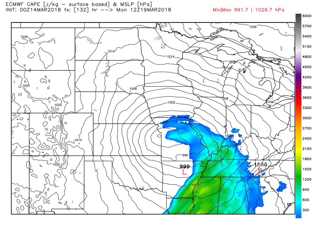
The GFS shows an area of low pressure passing to our north and northwest Monday and Monday night. This would if true, place us in the warm sector of that system. That would spell showers and thunderstorms.
The EC guidance shows some CAPE. CAPE is basically energy for thunderstorms. It can be a signal for severe thunderstorms. Let’s keep an eye on Monday.
Here are the EC CAPE numbers for Monday and Monday night. The EC brings the front through our region late Monday night and Tuesday morning.
This is the 7 AM CAPE map. Typically, we don’t experience a lot of severe weather during that time of the day. With that said, it is not a rule. I have witnessed severe weather at all hours of the day.
There also remain some questions about the exact timing of the cold front. Monitor updates.
Right now, the SPC has not outlined our region for severe weather Sunday night into Monday. I would recommend, however, monitoring updates. They may need to outline portions of our region.
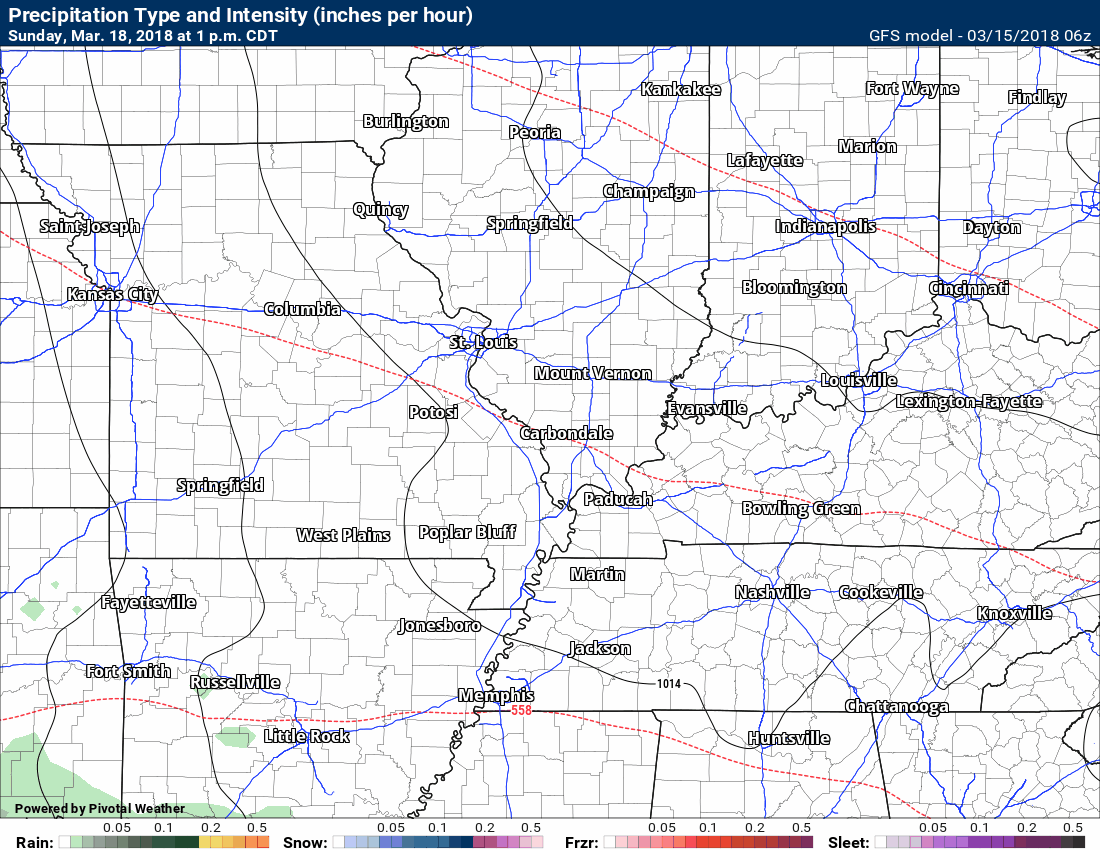
This next animation is the GFS future-cast radar. What radar might look like as we move into Sunday night and Monday.
This graphic takes us from Sunday 1 PM through Tuesday night. The GFS even shows the rain ending as flurries. Uggg. Not what we want! Let’s hope the GFS model guidance is wrong.
Green is rain. Yellow is heavier rain. Blue is snow.
Timestamp upper left.

Weather Brains is a weekly podcast/video for those who love weather and want more!
Weather Brains episode number 633
Previous episodes can be viewed by clicking here.
t’s a full house for this episode of WeatherBrains with representatives from a number of weather-related podcasts. Joining us are Becky DePodwin, Ice Station Housman, Scotty Powell from Carolina Weather Gang, Castle Williams,
WeatherHype
, Mark Jelinek, What is it About the Weather, and Phil Johnson of Storm Front Freaks Podcast. This show marks National Weather Podcast Month.
Other discussions in this weekly podcast include topics like:
- Extremes: 98 at Rio Grande Village, TX, and -7 at Cut Bank, MT
- The creative outlet that is podcasts and how they have changed over time
- The importance of providing good content in podcasting
- 25th Anniversary of Blizzard of 1993
- Astronomy Outlook with Tony Rice
- and more!

We offer interactive local city live radars and regional radars. If a radar does not update then try another one. If a radar does not appear to be refreshing then hit Ctrl F5. You may also try restarting your browser.
The local city view radars also have clickable warnings.
During the winter months, you can track snow and ice by clicking the winterize button on the local city view interactive radars.
You may email me at beaudodson@usawx.com
Find me on Facebook!

Find me on Twitter!

Did you know that a portion of your monthly subscription helps support local charity projects?
You can learn more about those projects by visiting the Shadow Angel Foundation website and the Beau Dodson News website.

I encourage subscribers to use the app vs regular text messaging. We have found text messaging to be delayed during severe weather. The app typically will receive the messages instantly. I recommend people have three to four methods of receiving their severe weather information.
Remember, my app and text alerts are hand typed and not computer generated. You are being given personal attention during significant weather events.
