
The big weather story over the coming days will likely be the warm front on Friday into the weekend.
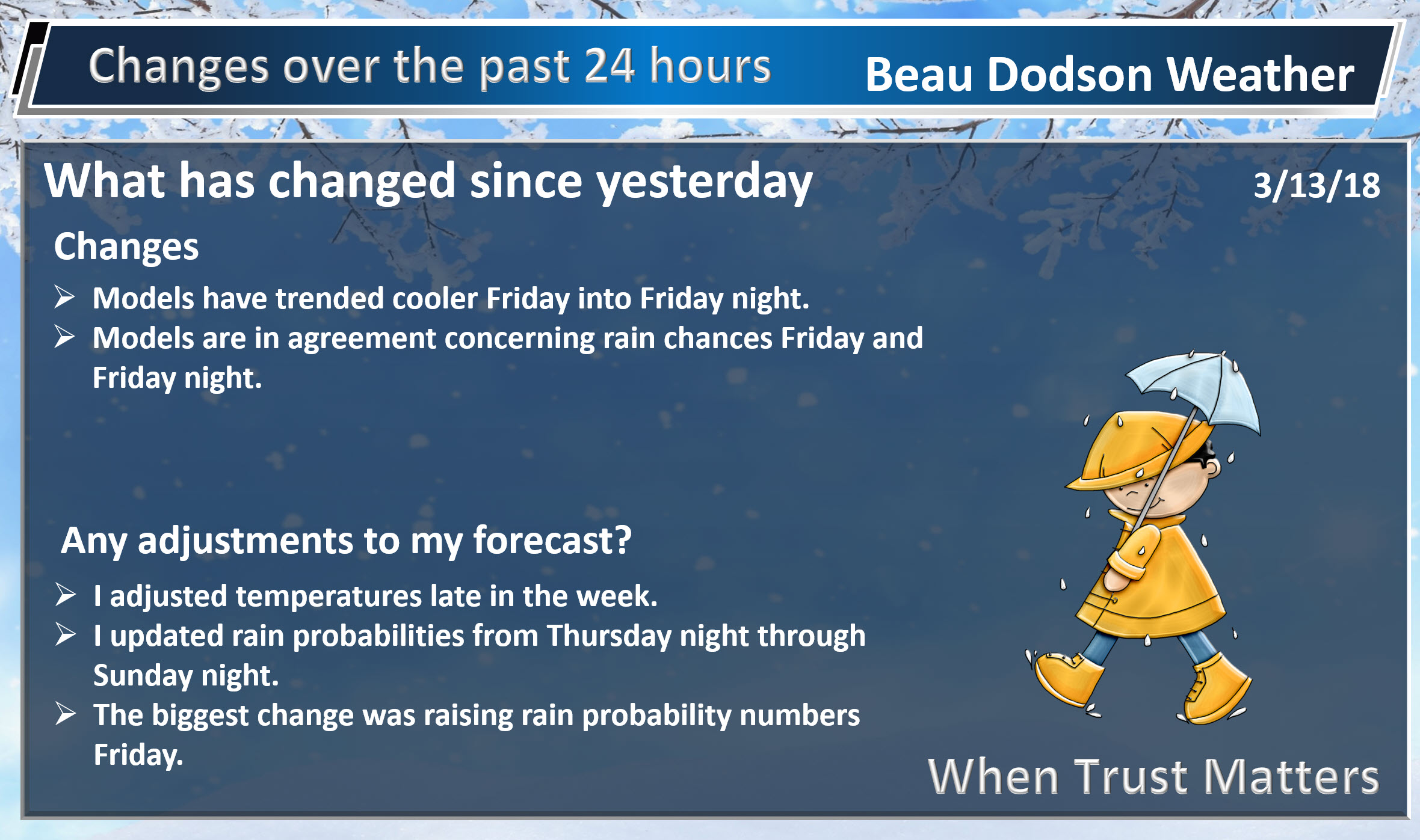
There have been WILD swings in model guidance temperatures for the Friday into Sunday time frame.
At one time it appeared the 70’s would be possible. Now it appears that may not be the case and chilly temperatures may prevail.
The problem centers around the placement of a warm front. That warm front is key to temperatures.
It is too early to know the exact placement of that front.
Let me show you the NWS forecast for 4 PM Saturday. This was the forecast that was issued around 1 AM Tuesday.
This was the forecast issued at 7 AM. QUITE the difference.
Let’s keep an eye on the weekend forecast. Strong thunderstorms will occur south of the warm front.
At this time, it appears the strong storms will stay to our south. IF the warm front is further north then our thunderstorm chances will increase.

March 13, 2018
Tuesday Forecast Details
Forecast: Patchy morning fog. Partly sunny. Chilly.
Temperatures: MO ~ 43 to 48 IL ~ 40 to 45 KY ~ 42 to 46 TN ~ 44 to 48
What is the chance of precipitation? MO ~ 0% IL ~ 0% KY ~ 0% TN ~ 0%
Coverage of precipitation: None
Winds: North and northwest at 8 to 16 mph
What impacts are anticipated from the weather? Low visibility in areas with fog early in the morning.
My confidence in the forecast verifying: High
Is severe weather expected? No
The NWS defines severe weather as 58 mph wind or great, 1″ hail or larger, and/or tornadoes
Should I cancel my outdoor plans? No
Sunrise 7:08 AM
Tuesday Night Forecast Details:
Forecast: A few evening showers. Showers may mix with sleet over our eastern counties. Rain chances are mostly from Mt Vernon, IL towards the Pennyrile area of western Kentucky. They won’t last long. Clearing overnight and cold. Patchy fog possible.
Temperatures: MO ~ 24 to 28 IL ~ 24 to 28 KY ~ 24 to 28 TN ~ 24 to 28
What is the chance of precipitation? MO ~ 0% IL ~ 30% KY ~ 30% TN ~ 0%
Coverage of precipitation: None
Winds: North and northwest at 10 to 20 mph
What impacts are anticipated from the weather? None
My confidence in the forecast verifying: High
Is severe weather expected? No
The NWS defines severe weather as 58 mph wind or great, 1″ hail or larger, and/or tornadoes
Should I cancel my outdoor plans? No
Sunset 6:59 PM
March 14, 2018
Wednesday Forecast Details
Forecast: Mostly sunny. Cool.
Temperatures: MO ~ 46 to 52 IL ~ 45 to 48 KY ~ 46 to 50 TN ~ 46 to 52
What is the chance of precipitation? MO ~ 0% IL ~ 0% KY ~ 0% TN ~ 0%
Coverage of precipitation: None
Winds: West and northwest 5 to 10 mph with gusts to 12
What impacts are anticipated from the weather? None
My confidence in the forecast verifying: High
Is severe weather expected? No
The NWS defines severe weather as 58 mph wind or great, 1″ hail or larger, and/or tornadoes
Should I cancel my outdoor plans? No
Sunrise 7:06 AM
Wednesday Night Forecast Details:
Forecast: Mostly clear and cool.
Temperatures: MO ~ 34 to 38 IL ~ 33 to 36 KY ~ 34 to 38 TN ~ 34 to 38
What is the chance of precipitation? MO ~ 0% IL ~ 0% KY ~ 0% TN ~ 0%
Coverage of precipitation: None
Winds: Becoming southwest at 10 to 20 mph and gusty
What impacts are anticipated from the weather? None
My confidence in the forecast verifying: High
Is severe weather expected? No
The NWS defines severe weather as 58 mph wind or great, 1″ hail or larger, and/or tornadoes
Should I cancel my outdoor plans? No
Sunset 7:00 PM
March 15, 2018
Thursday Forecast Details
Forecast: Mostly sunny. Milder.
Temperatures: MO ~ 62 to 64 IL ~ 58 to 62 KY ~ 60 to 64 TN ~ 60 to 65
What is the chance of precipitation? MO ~ 0% IL ~ 0% KY ~ 0% TN ~ 0%
Coverage of precipitation: None
Winds: West and southwest 7 to 14 mph
What impacts are anticipated from the weather? None
My confidence in the forecast verifying: High
Is severe weather expected? No
The NWS defines severe weather as 58 mph wind or great, 1″ hail or larger, and/or tornadoes
Should I cancel my outdoor plans? No
Sunrise 7:05 AM
Thursday Night Forecast Details:
Forecast: Mostly clear early. Increasing clouds through the night. Showers developing from the west and southwest late at night. A rumble of thunder possible.
Temperatures: MO ~ 42 to 46 IL ~ 42 to 46 KY ~ 44 to 46 TN ~ 44 to 48
What is the chance of precipitation? MO ~ 40% IL ~ 40% KY ~ 40% TN ~ 40%
Coverage of precipitation: None early. Becoming scattered late.
Winds: South and southwest at 5 to 10 mph with gusts to 12 mph
What impacts are anticipated from the weather? Wet roadways.
My confidence in the forecast verifying: Medium
Is severe weather expected? No
The NWS defines severe weather as 58 mph wind or great, 1″ hail or larger, and/or tornadoes
Should I cancel my outdoor plans? No
Sunset 7:01 PM
Rain chances will likely need adjusting as we move through the week. Highest rain probabilities may end up being Friday and Friday night.
Rain chances may last into early next week. On and off rain chances.
Temperatures may need adjusting, as well.
A strong warm front will be near our region. There could be a 20 to 30-degree difference north vs south of that front.
March 16, 2018
Friday Forecast Details
Forecast: Mostly cloudy. Widespread rain developing. A rumble of thunder possible. Cooler north of the warm front. Warmer south of the warm front. Where that front is located will need to be monitored.
Temperatures: MO ~ 54 to 58 IL ~ 46 to 52 KY ~ 53 to 56 TN ~ 53 to 56
What is the chance of precipitation? MO ~ 80% IL ~ 80% KY ~ 80% TN ~ 80%
Coverage of precipitation: Widespread
Winds: East and southeast 7 to 14 mph with gusts to 25 mph
What impacts are anticipated from the weather? Wet roadways. Perhaps lightning.
My confidence in the forecast verifying: Medium
Is severe weather expected? Unlikely, but monitor updates
The NWS defines severe weather as 58 mph wind or great, 1″ hail or larger, and/or tornadoes
Should I cancel my outdoor plans? Have a plan B and monitor updates.
Sunrise 7:03 AM
Friday Night Forecast Details:
Forecast: Cloudy. Showers likely. A chance of a thunderstorm. Temperatures will vary based on the location of the warm front.
Temperatures: MO ~ 36 to 44 IL ~ 35 to 42 KY ~ 38 to 44 TN ~ 38 to 44
What is the chance of precipitation? MO ~ 60% IL ~ 60% KY ~ 60% TN ~ 60%
Coverage of precipitation: Numerous
Winds: East and southeast at 8 to 16 mph with gusts to 22 mph
What impacts are anticipated from the weather? Wet roadways. Lightning.
My confidence in the forecast verifying: Medium.
Is severe weather expected? Unlikely, but monitor updates.
The NWS defines severe weather as 58 mph wind or great, 1″ hail or larger, and/or tornadoes
Should I cancel my outdoor plans? Have a plan B and monitor updates.
Sunset 7:02 PM
March 17, 2018
Saturday Forecast Details
Forecast: Mostly cloudy. Showers possible.
Temperatures: MO ~ 56 to 62 IL ~ 56 to 62 KY ~ 56 to 62 TN ~ 56 to 62
What is the chance of precipitation? MO ~ 30% IL ~ 30% KY ~ 30% TN ~ 30%
Coverage of precipitation: Scattered
Winds: East and northeast at 5 to 10 mph
What impacts are anticipated from the weather? Wet roadways. Lightning.
My confidence in the forecast verifying: LOW
Is severe weather expected? Unlikely
The NWS defines severe weather as 58 mph wind or great, 1″ hail or larger, and/or tornadoes
Should I cancel my outdoor plans? Monitor updates.
Sunrise 7:02 AM
Saturday Night Forecast Details:
Forecast: Cloudy. An isolated shower.
Temperatures: MO ~ 40 to 45 IL ~ 40 to 44 KY ~ 40 to 45 TN ~ 43 to 46
What is the chance of precipitation? MO ~ 20% IL ~ 20% KY ~ 20% TN ~ 20%
Coverage of precipitation: Isolated
Winds: North and northeast at 5 to 10 mph
What impacts are anticipated from the weather? Wet roadways.
My confidence in the forecast verifying: LOW
Is severe weather expected? No
The NWS defines severe weather as 58 mph wind or great, 1″ hail or larger, and/or tornadoes
Should I cancel my outdoor plans? No
Sunset 7:03 PM
March 18, 2018
Sunday Forecast Details
Forecast: Partly sunny and warmer. A shower possible in the Missouri Bootheel.
Temperatures: MO ~ 60 to 65 IL ~ 60 to 65 KY ~ 62 to 66 TN ~ 62 to 66
What is the chance of precipitation? MO ~ 20% IL ~ 10% KY ~ 10% TN ~ 10%
Coverage of precipitation: None to isolated
Winds: Southeast at 6 to 12 mph
What impacts are anticipated from the weather? Most likely none.
My confidence in the forecast verifying: LOW
Is severe weather expected? No
The NWS defines severe weather as 58 mph wind or great, 1″ hail or larger, and/or tornadoes
Should I cancel my outdoor plans? No
Sunrise 7:00 AM
Sunday Night Forecast Details:
Forecast: Cloudy. A chance of showers and thunderstorms.
Temperatures: MO ~ 42 to 46 IL ~ 42 to 46 KY ~ 42 to 46 TN ~ 42 to 46
What is the chance of precipitation? MO ~ 40% IL ~ 40% KY ~ 40% TN ~ 40%
Coverage of precipitation: Scattered
Winds: South at 5 to 10 mph
What impacts are anticipated from the weather? Wet roadways. Lightning.
My confidence in the forecast verifying: LOW
Is severe weather expected? Unlikely
The NWS defines severe weather as 58 mph wind or great, 1″ hail or larger, and/or tornadoes
Should I cancel my outdoor plans? Monitor updates.
Sunset 7:04 PM

Questions? Broken links? Other?
You may email me at beaudodson@usawx.com

The National Weather Service defines a severe thunderstorm as one that produces quarter size hail or larger, 58 mph winds or greater, and/or a tornado.
Today and tonight: Severe weather is not anticipated.
Tomorrow through Thursday night: Severe weather is not anticipated.
Friday through Monday: Lightning is possible Friday. I will monitor the risk of stronger storms. There remain questions about the placement of the warm front and the unstable air. It may be to our south. Monitor updates.
I am monitoring Saturday into Monday for lightning, as well. Low confidence, for now.
![]()
Interactive live weather radar page. Choose the city nearest your location. If one of the cities does not work then try a nearby one. Click here.
National map of weather watches and warnings. Click here.
Storm Prediction Center. Click here.
Weather Prediction Center. Click here.

Live lightning data: Click here.

Interactive GOES R satellite. Track clouds. Click here.

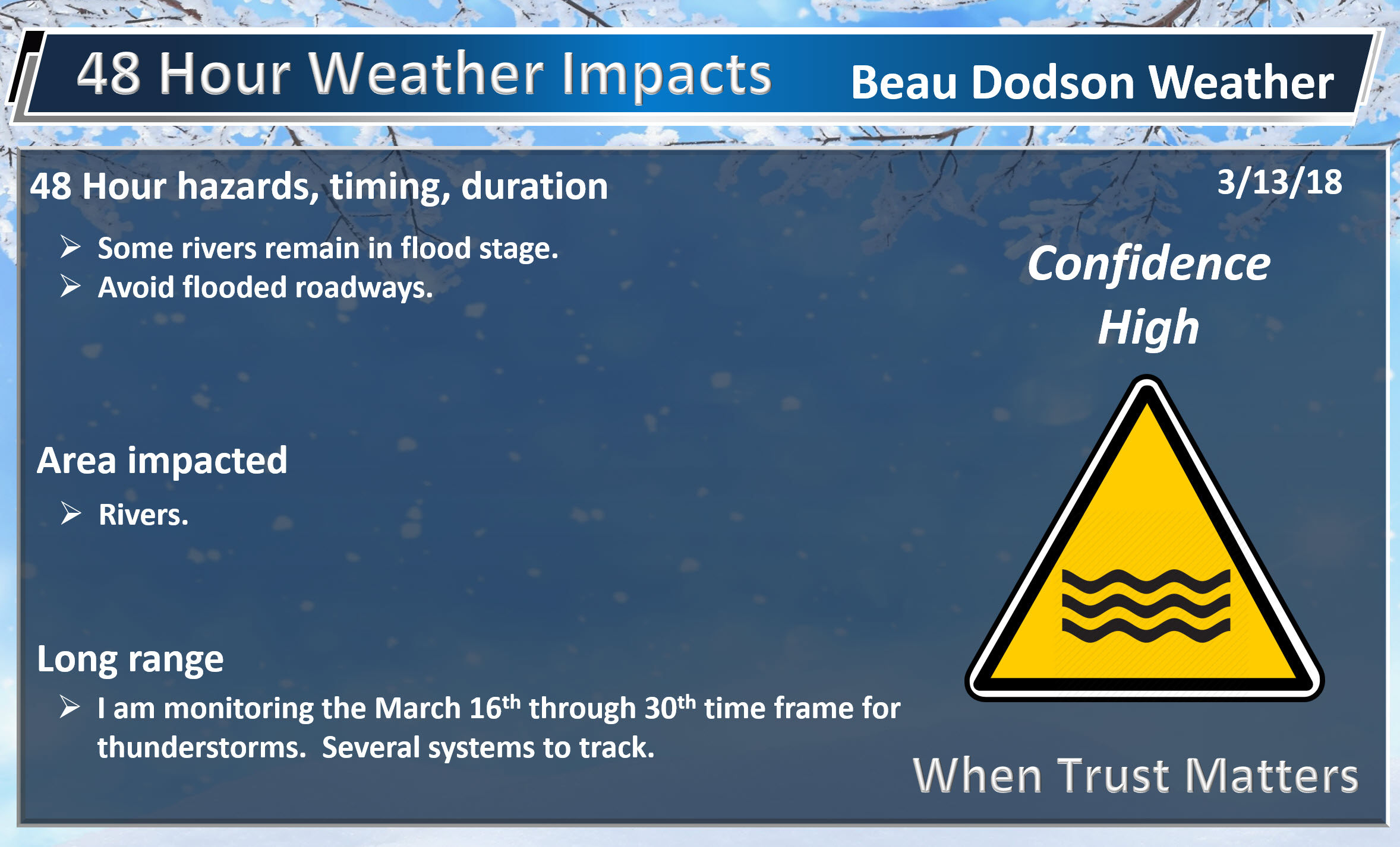
Here are the latest local river stage forecast numbers Click Here.
Here are the latest lake stage forecast numbers for Kentucky Lake and Lake Barkley Click Here.

The spring and preliminary summer outlooks have been posted for subscribers. Scroll down to see the outlook.
Not a subscriber? Learn more at this link.

WEATHER HIGHLIGHTS
- Calm today. Cool temperatures.
- Dry weather today through Thursday.
- A period of unsettled weather from late Thursday night into next week.
- Flooding will continue to be an issue in some areas. Avoid flooded roadways.
- In case you missed it! Here is the Facebook thread with some exciting new announcements concerning Weather Talk. Click here to read that.
Highlights

What has changed over the last 24 hours?
Weather Hazards.
We are waking up to a chilly morning. Lows in the region were in the 20’s and 30’s.
We still have some snow cover over parts of southeast Illinois and western Kentucky. That will continue to melt away as temperatures rise over the coming days.
It will be cool today with below normal temperatures. Highs mostly in the 40’s.
We will remain cool Wednesday and Wednesday night.
The good news is that we will see temperatures rise into the 60’s by Thursday. The bad news is that rain chances will increase Thursday night into a portion of the weekend.
Peak rain chances will arrive Friday and Friday night. A few rumbles of thunder are also possible.
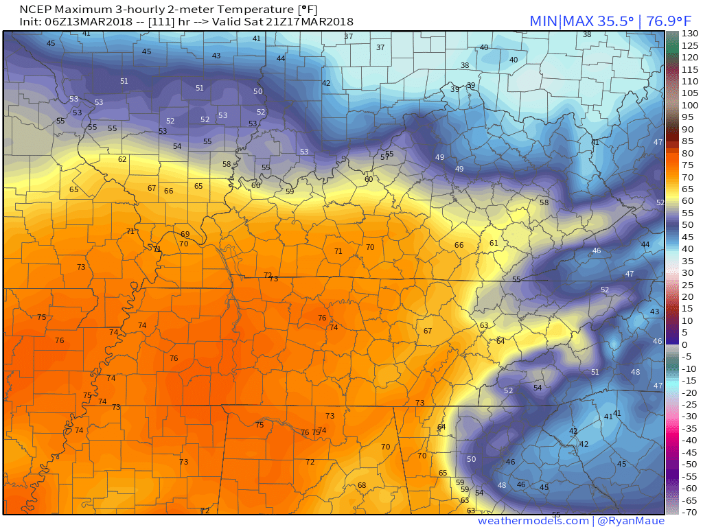
Friday’s temperatures may be cooler, because of the placement of a warm front, clouds, and rain. As a matter of fact, some of the guidance is downright cold.
Here is the GFS model. This could be a bit too chilly but will need to be monitored.

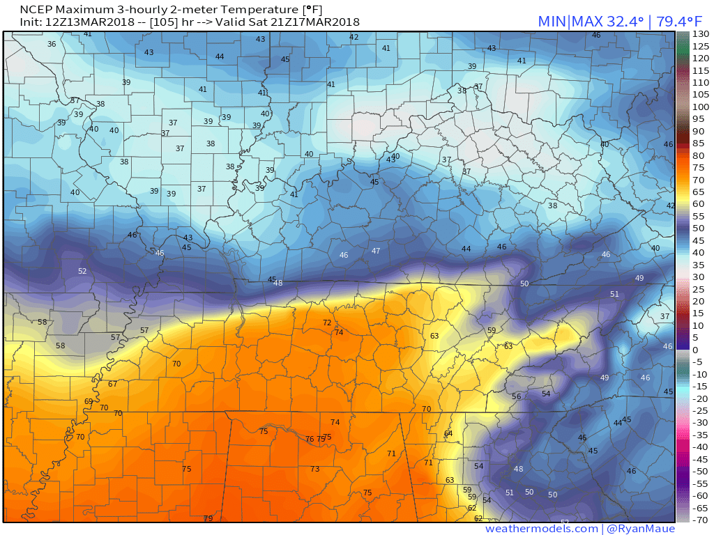
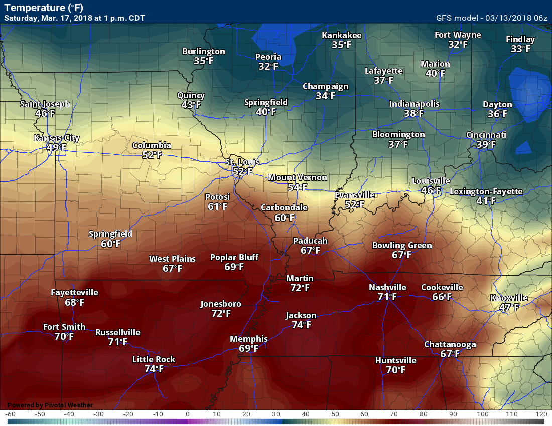
Saturday should warm up a bit. The warm front may lift northeastward. If so, we will warm up.
Here is the 1 PM temperature map from the GFS guidance. This is Saturday.
The Storm Prediction Center has outlined a severe weather risk to our south. You can see that here.
Over the last two weeks, I had been forecasting a possible thunderstorm event around the 16th into the 19th. That is still on the table, but our region may remain north of the warmer and more unstable air (monitor updates).
Since this is still days away, you can expect the SPC to shift this outlook around with each passing day.
For now, it appears the severe weather risk will stay south of my forecast counties, but let’s keep a close eye on it.
If the warm front shifts further north then our thunderstorm chances would increase.
The yellow zone is where the SPC currently has a risk of severe thunderstorms Friday.

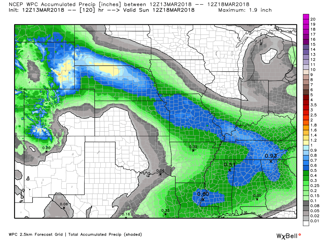
Rainfall totals Thursday night (late) into Sunday night will likely range from 0.40″ to 0.80″. Locally higher totals are possible.
Here is the latest NOAA rainfall outlook. This takes us through the weekend.
Notice the northwest to southeast band of rain. That is because the warm front will be situated over our southern counties. The heaviest rain will train along the warm front.
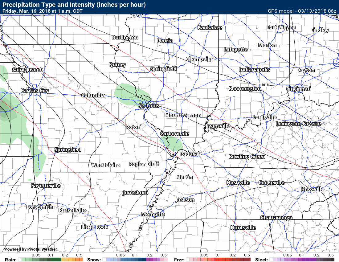
Here is the future-cast radar from the GFS model guidance. Keep in mind, this is a model and not gospel. It won’t be exact. Just take the general idea from this graphic that some rain will be possible late Thursday night and then on/off into early next week.
There is some debate about rain probabilities Saturday into Sunday night. For now, I have placed them in the low range, but they might need adjusting. Monitor updates if you have weekend plans.
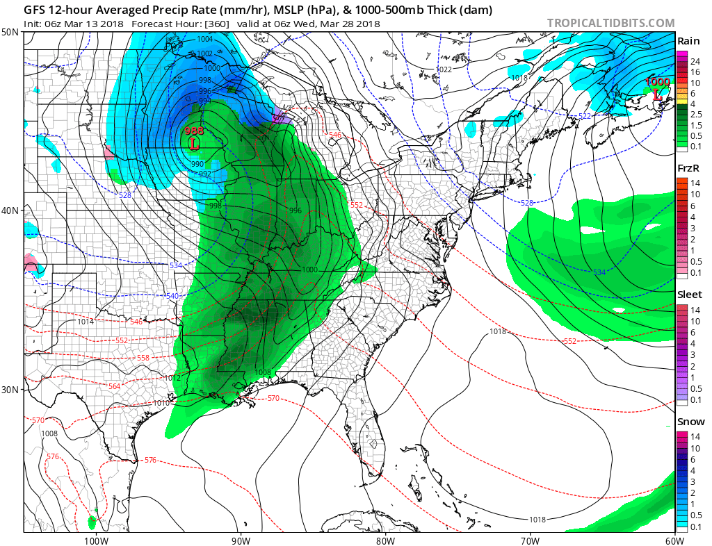
The long-range outlook appears to be shaping up as a stormy one. Spring is knocking on our door.
For example, the GFS is painting this. A series of low-pressure centers with cold fronts sweeping through our region.
The long-range outlook is for stormy weather.
This is in the long-range, so the confidence, of course, is low. I just want to show you the idea that we may have stormy weather as we move later into March.
This is March 22nd/23rd.

This is March 27th and 28th.

Weather Brains is a weekly podcast/video for those who love weather and want more!
Weather Brains episode number 633
Previous episodes can be viewed by clicking here.
t’s a full house for this episode of WeatherBrains with representatives from a number of weather-related podcasts. Joining us are Becky DePodwin, Ice Station Housman, Scotty Powell from Carolina Weather Gang, Castle Williams,
WeatherHype
, Mark Jelinek, What is it About the Weather, and Phil Johnson of Storm Front Freaks Podcast. This show marks National Weather Podcast Month.
Other discussions in this weekly podcast include topics like:
- Extremes: 98 at Rio Grande Village, TX, and -7 at Cut Bank, MT
- The creative outlet that is podcasts and how they have changed over time
- The importance of providing good content in podcasting
- 25th Anniversary of Blizzard of 1993
- Astronomy Outlook with Tony Rice
- and more!

We offer interactive local city live radars and regional radars. If a radar does not update then try another one. If a radar does not appear to be refreshing then hit Ctrl F5. You may also try restarting your browser.
The local city view radars also have clickable warnings.
During the winter months, you can track snow and ice by clicking the winterize button on the local city view interactive radars.
You may email me at beaudodson@usawx.com
Find me on Facebook!

Find me on Twitter!

Did you know that a portion of your monthly subscription helps support local charity projects?
You can learn more about those projects by visiting the Shadow Angel Foundation website and the Beau Dodson News website.

I encourage subscribers to use the app vs regular text messaging. We have found text messaging to be delayed during severe weather. The app typically will receive the messages instantly. I recommend people have three to four methods of receiving their severe weather information.
Remember, my app and text alerts are hand typed and not computer generated. You are being given personal attention during significant weather events.
