
I lowered temps tomorrow. I also added more clouds tonight and tomorrow afternoon.
Today has been several degrees cooler than anticipated. I did adjust the afternoon temperatures, as well.
Here is the GFS animation over the next 180 hours. Several systems to monitor.

March 12, 2018
Monday Forecast Details
Forecast: Mostly sunny early. Increasing clouds afternoon. Cooler. Breezy.
Temperatures: MO ~ 38 to 44 IL ~ 36 to 44 KY ~ 38 to 45 TN ~ 44 to 48
What is the chance of precipitation? MO ~ 0% IL ~ 0% KY ~ 0% TN ~ 0%
Coverage of precipitation: None
Winds: North and northwest at 10 to 20 mph
What impacts are anticipated from the weather? None
My confidence in the forecast verifying: High
Is severe weather expected? No
The NWS defines severe weather as 58 mph wind or great, 1″ hail or larger, and/or tornadoes
Should I cancel my outdoor plans? No
Sunrise 7:09 AM
Monday Night Forecast Details:
Forecast: Some clouds. Some clearing. Colder where snow remains on the ground. Patchy fog possible. Cold.
Temperatures: MO ~ 25 to 28 IL ~ 24 to 28 KY ~ 24 to 28 TN ~ 28 to 34
What is the chance of precipitation? MO ~ 0% IL ~ 0% KY ~ 0% TN ~ 0%
Coverage of precipitation: None
Winds: North and northwest at 6 to 12 mph
What impacts are anticipated from the weather? Low visibility where fog occurs.
My confidence in the forecast verifying: High
Is severe weather expected? No
The NWS defines severe weather as 58 mph wind or great, 1″ hail or larger, and/or tornadoes
Should I cancel my outdoor plans? No
Sunset 6:58 PM
March 13, 2018
Tuesday Forecast Details
Forecast: Patchy morning fog. Partly sunny. More clouds over our eastern counties vs west.
Temperatures: MO ~ 38 to 44 IL ~ 38 to 44 KY ~ 38 to 45 TN ~ 44 to 48
What is the chance of precipitation? MO ~ 0% IL ~ 0% KY ~ 0% TN ~ 0%
Coverage of precipitation: None
Winds: North 5 to 10 mph
What impacts are anticipated from the weather? Low visibility in areas with fog early in the morning.
My confidence in the forecast verifying: High
Is severe weather expected? No
The NWS defines severe weather as 58 mph wind or great, 1″ hail or larger, and/or tornadoes
Should I cancel my outdoor plans? No
Sunrise 7:08 AM
Tuesday Night Forecast Details:
Forecast: Mostly clear and cool.
Temperatures: MO ~ 24 to 28 IL ~ 24 to 28 KY ~ 24 to 28 TN ~ 24 to 28
What is the chance of precipitation? MO ~ 0% IL ~ 0% KY ~ 0% TN ~ 0%
Coverage of precipitation: None
Winds: North and northwest at 4 to 8 mph
What impacts are anticipated from the weather? None
My confidence in the forecast verifying: High
Is severe weather expected? No
The NWS defines severe weather as 58 mph wind or great, 1″ hail or larger, and/or tornadoes
Should I cancel my outdoor plans? No
Sunset 6:59 PM
March 14, 2018
Wednesday Forecast Details
Forecast: Mostly sunny. Cool.
Temperatures: MO ~ 44 to 48 IL ~ 44 to 48 KY ~ 45 to 50 TN ~ 46 to 52
What is the chance of precipitation? MO ~ 0% IL ~ 0% KY ~ 0% TN ~ 0%
Coverage of precipitation: None
Winds: West and northwest 5 to 10 mph
What impacts are anticipated from the weather? None
My confidence in the forecast verifying: High
Is severe weather expected? No
The NWS defines severe weather as 58 mph wind or great, 1″ hail or larger, and/or tornadoes
Should I cancel my outdoor plans? No
Sunrise 7:06 AM
Wednesday Night Forecast Details:
Forecast: Mostly clear and cool.
Temperatures: MO ~ 28 to 34 IL ~ 28 to 34 KY ~ 28 to 34 TN ~ 30 to 35
What is the chance of precipitation? MO ~ 0% IL ~ 0% KY ~ 0% TN ~ 0%
Coverage of precipitation: None
Winds: Becoming southwest at 4 to 8 mph
What impacts are anticipated from the weather? None
My confidence in the forecast verifying: High
Is severe weather expected? No
The NWS defines severe weather as 58 mph wind or great, 1″ hail or larger, and/or tornadoes
Should I cancel my outdoor plans? No
Sunset 7:00 PM
March 15, 2018
Thursday Forecast Details
Forecast: Mostly sunny. Milder.
Temperatures: MO ~ 56 t0 62 IL ~ 56 to 62 KY ~ 56 to 62 TN ~ 56 to 62
What is the chance of precipitation? MO ~ 0% IL ~ 0% KY ~ 0% TN ~ 0%
Coverage of precipitation: None
Winds: West and southwest 7 to 14 mph
What impacts are anticipated from the weather? None
My confidence in the forecast verifying: High
Is severe weather expected? No
The NWS defines severe weather as 58 mph wind or great, 1″ hail or larger, and/or tornadoes
Should I cancel my outdoor plans? No
Sunrise 7:05 AM
Thursday Night Forecast Details:
Forecast: Mostly clear early. A few late night clouds. A slight chance of a shower after midnight.
Temperatures: MO ~ 44 to 48 IL ~ 44 to 48 KY ~ 44 to 46 TN ~ 44 to 48
What is the chance of precipitation? MO ~ 10% IL ~ 10% KY ~ 10% TN ~ 10%
Coverage of precipitation: None to isolated
Winds: South and southwest at 5 to 10 mph
What impacts are anticipated from the weather? Most likely none.
My confidence in the forecast verifying: Medium
Is severe weather expected? No
The NWS defines severe weather as 58 mph wind or great, 1″ hail or larger, and/or tornadoes
Should I cancel my outdoor plans? No
Sunset 7:01 PM
Rain chances will likely need adjusting as we move through the week. Highest rain probabilities may end up being Friday and Friday night.
Rain chances may last into early next week. On and off rain chances.
Temperatures may need adjusting, as well.
March 16, 2018
Friday Forecast Details
Forecast: Mostly cloudy. A chance of showers and perhaps a thunderstorm.
Temperatures: MO ~ 52 to 56 IL ~ 52 to 56 KY ~ 52 to 56 TN ~ 53 to 56
What is the chance of precipitation? MO ~ 60% IL ~ 60% KY ~ 60% TN ~ 60%
Coverage of precipitation: Scattered to perhaps numerous
Winds: West and southwest 7 to 14 mph
What impacts are anticipated from the weather? Wet roadways. Perhaps lightning.
My confidence in the forecast verifying: Medium
Is severe weather expected? Unlikely
The NWS defines severe weather as 58 mph wind or great, 1″ hail or larger, and/or tornadoes
Should I cancel my outdoor plans? Monitor updates.
Sunrise 7:03 AM
Friday Night Forecast Details:
Forecast: Cloudy. Showers likely. A chance of a thunderstorm.
Temperatures: MO ~ 38 to 44 IL ~ 38 to 44 KY ~ 38 to 44 TN ~ 38 to 44
What is the chance of precipitation? MO ~ 60% IL ~ 60% KY ~ 60% TN ~ 60%
Coverage of precipitation: Numerous
Winds: South at 5 to 10 mph
What impacts are anticipated from the weather? Wet roadways. Lightning.
My confidence in the forecast verifying: Medium.
Is severe weather expected? Unlikely
The NWS defines severe weather as 58 mph wind or great, 1″ hail or larger, and/or tornadoes
Should I cancel my outdoor plans? Monitor updates.
Sunset 7:02 PM
March 17, 2018
Saturday Forecast Details
Forecast: Mostly cloudy. A chance of showers and perhaps a thunderstorm.
Temperatures: MO ~ 56 to 62 IL ~ 56 to 62 KY ~ 56 to 62 TN ~ 56 to 62
What is the chance of precipitation? MO ~ 40% IL ~ 40% KY ~ 40% TN ~ 40%
Coverage of precipitation: Scattered to perhaps numerous
Winds: West and southwest 7 to 14 mph
What impacts are anticipated from the weather? Wet roadways. Lightning.
My confidence in the forecast verifying: Medium
Is severe weather expected? Unlikely
The NWS defines severe weather as 58 mph wind or great, 1″ hail or larger, and/or tornadoes
Should I cancel my outdoor plans? Monitor updates.
Sunrise 7:02 AM
Saturday Night Forecast Details:
Forecast: Cloudy. Showers possible. A chance of a thunderstorm.
Temperatures: MO ~ 45 to 50 IL ~ 45 to 50 KY ~ 45 to 50 TN ~ 45 to 50
What is the chance of precipitation? MO ~ 40% IL ~ 40% KY ~ 40% TN ~ 40%
Coverage of precipitation: Scattered
Winds: South at 5 to 10 mph
What impacts are anticipated from the weather? Wet roadways. Lightning.
My confidence in the forecast verifying: Medium
Is severe weather expected? Unlikely
The NWS defines severe weather as 58 mph wind or great, 1″ hail or larger, and/or tornadoes
Should I cancel my outdoor plans? Monitor updates.
Sunset 7:03 PM
March 18, 2018
Sunday Forecast Details
Forecast: Mostly cloudy. A chance of showers and perhaps a thunderstorm. Mild.
Temperatures: MO ~ 66 to 72 IL ~ 66 to 72 KY ~ 66 to 72 TN ~ 66 to 72
What is the chance of precipitation? MO ~ 40% IL ~ 40% KY ~ 40% TN ~ 40%
Coverage of precipitation: Scattered
Winds: South 6 to 12 mph
What impacts are anticipated from the weather? Wet roadways. Perhaps lightning.
My confidence in the forecast verifying: Medium
Is severe weather expected? Unlikely
The NWS defines severe weather as 58 mph wind or great, 1″ hail or larger, and/or tornadoes
Should I cancel my outdoor plans? Monitor updates.
Sunrise 7:00 AM
Sunday Night Forecast Details:
Forecast: Cloudy. Showers likely. A chance of a thunderstorm.
Temperatures: MO ~ 52 to 56 IL ~ 52 to 56 KY ~ 52 to 56 TN ~ 52 to 56
What is the chance of precipitation? MO ~ 40% IL ~ 40% KY ~ 40% TN ~ 40%
Coverage of precipitation: Scattered
Winds: South at 5 to 10 mph
What impacts are anticipated from the weather? Wet roadways. Lightning.
My confidence in the forecast verifying: Medium.
Is severe weather expected? Unlikely
The NWS defines severe weather as 58 mph wind or great, 1″ hail or larger, and/or tornadoes
Should I cancel my outdoor plans? Monitor updates.
Sunset 7:04 PM

Questions? Broken links? Other?
You may email me at beaudodson@usawx.com

The National Weather Service defines a severe thunderstorm as one that produces quarter size hail or larger, 58 mph winds or greater, and/or a tornado.
Today and tonight: Severe weather is not anticipated.
Tomorrow through Thursday night: Severe weather is not anticipated.
Friday through Monday: Thunderstorms are possible. I am monitoring Sunday night into Monday night for the potential of stronger thunderstorms.
![]()
Interactive live weather radar page. Choose the city nearest your location. If one of the cities does not work then try a nearby one. Click here.
National map of weather watches and warnings. Click here.
Storm Prediction Center. Click here.
Weather Prediction Center. Click here.

Live lightning data: Click here.

Interactive GOES R satellite. Track clouds. Click here.

Here are the latest local river stage forecast numbers Click Here.
Here are the latest lake stage forecast numbers for Kentucky Lake and Lake Barkley Click Here.

The spring and preliminary summer outlooks have been posted for subscribers. Scroll down to see the outlook.
Not a subscriber? Learn more at this link.

WEATHER HIGHLIGHTS
- Wow. What a winter storm. One of the more complicated forecasts of the winter season.
- Dry weather today through Thursday.
- A period of unsettled weather from late Thursday night into next week.
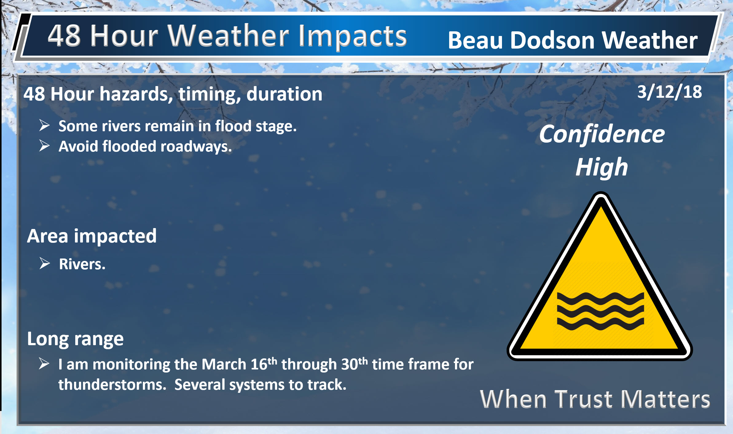
- Flooding will continue to be an issue in some areas. Avoid flooded roadways.
- In case you missed it! Here is the Facebook thread with some exciting new announcements concerning Weather Talk. Click here to read that.
Highlights

What has changed over the last 24 hours?
Weather Hazards.
Wow. What a weekend.
It was the most difficult forecast all winter. It was a no-win situation for some counties.
Check out the sharp gradient of snow on this satellite photograph. Snow. No snow.
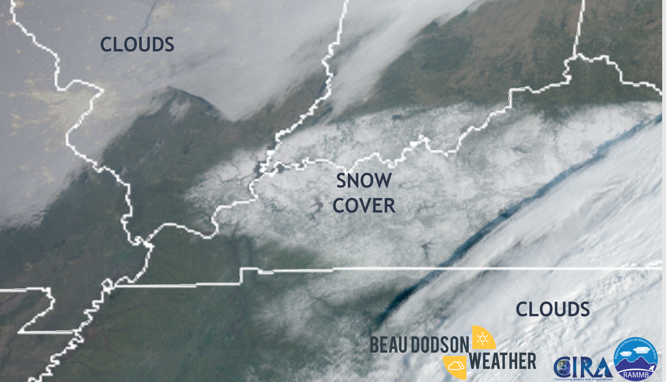
The forecast was almost spot on for southeast Missouri, southwest Illinois, extreme southwest Kentucky, and northwest Tennessee. The forecast there was no snow accumulation to perhaps an inch or two. Most areas received no snow accumulation.
The forecast did well across southeast Illinois and parts of west Kentucky. Snow totals range from a dusting to 5 inches.
The heaviest snow band was across Gallatin, Saline, and Pope Counties in Illinois. Livingston County, KY and the north and northeast of there. Totals of 2 to 5 inches occurred in these areas.
There were numerous accidents reported across southeast Illinois and western Kentucky.
The ground temperatures were in the 40’s. Road temperatures were in the 40’s. Air temperatures were 32 to 36 degrees.
Very difficult for snow to accumulate with these conditions. It took one to two inch per hour snow rates to accumulate. Thundersnow was also reported over southern Illinois.
The counties that did not do well were Ballard, Carlisle, Hickman, Graves, Calloway, Trigg, Christian, and Todd. These areas received little in the way of snow accumulation. I tried to emphasize the potential of no snow in some areas. Hopefully, that message came across.
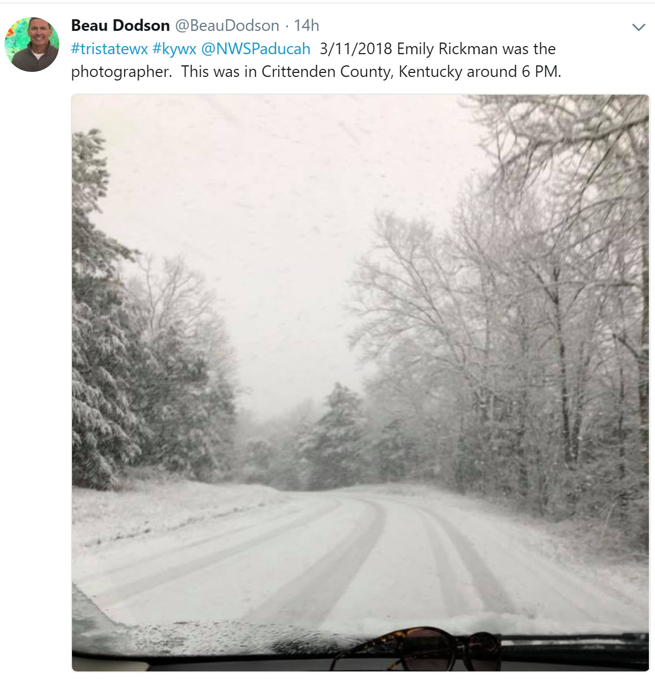
Want to see some snow photos? Check out my Twitter feed from last night. Click here.
Here is one photo, for example. Crittenden County, KY.
I went too high for snow accumulations across portions of the Pennyrile. I had to go back and lower those numbers.
There was a period of snow late Sunday night that did produce a dusting in some of those counties.
I did everything I could to repeatedly say that it was a low confidence forecast with a high risk of some areas receiving no snow.
Some areas that did receive several inches of snow reported much of that snow melting after the snow ended.
Tricky forecast! I gave it my best. I did several Facebook Live events, YouTube videos, updated the app/text throughout the day and night, Twitter had plenty of photos of the snow, and the Facebook winter storm threads. It was quite busy!
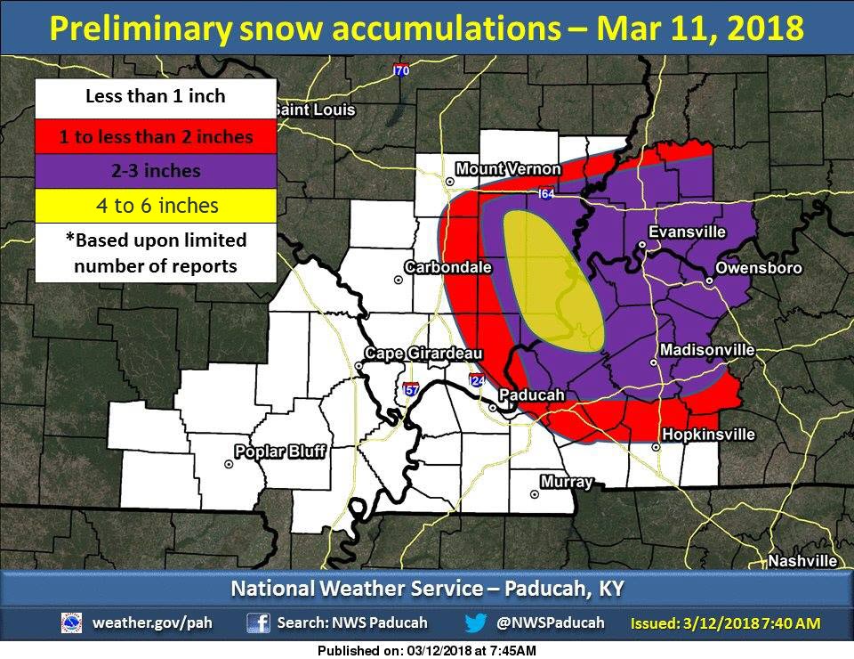
Here is a map issued by the NWS. This is based on a handful of reports. I did add up to 6 inches. Crittenden and Livingston Counties both had reports of 4 to 6 inches.
It was a practice run for severe weather “season”. I say season, but we have tornadoes year round.
The good news is that we will have a break today through Thursday. I can continue to prepare for severe weather season. Working on several projects.
We hope to have the new website finished soon. The app, as well.
It will be chilly, at times over the coming days. Several nights with 20’s will mean that sensitive plants will need shelter. Some of you have said you planted some flowers or placed a few plants outside. You might want to consider taking precautions to make sure those plants don’t die because of the below freezing temperatures.
Rain chances ramp up late Thursday night and especially Friday into the weekend. Thunderstorms will also be possible. The threat of severe weather, for the time being, appears low. Monitor forecasts.
Unsettled weather next week and the following. Several chances of thunderstorms. It is that time of the year. Monitor updates.
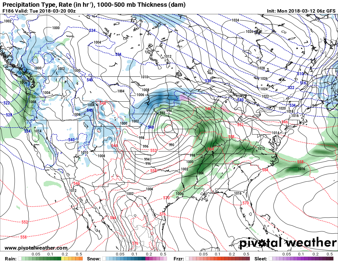
I am closely watching Sunday night into Monday night of next week. A stronger storm system could impact the Central United States.
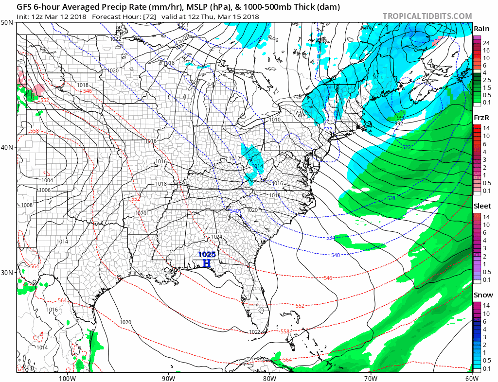
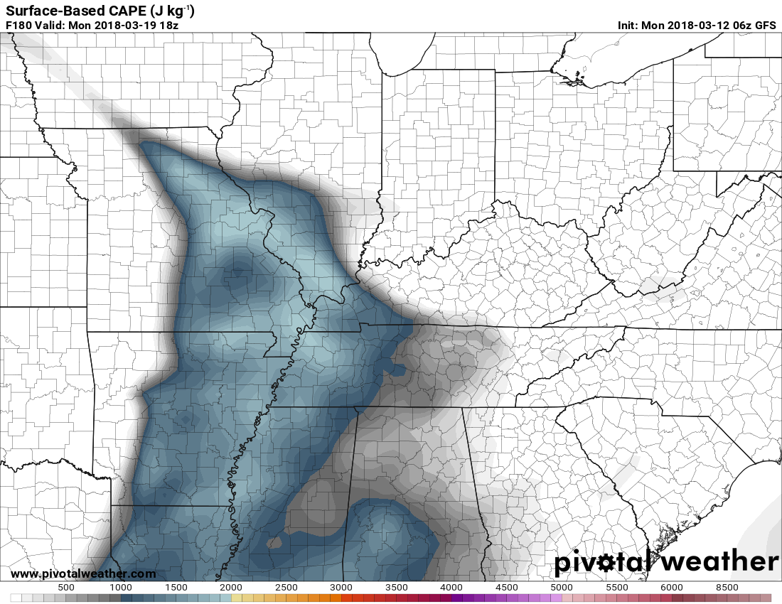
Here is that system on the GFS model.
The low is centered over Omaha, Nebraska. See the black lines? The circle over SE Nebraska is the low pressure center.
A trailing cold front will extend into Texas. A band of showers and thunderstorms in our region.
This graphic is 7 PM Monday. Long way off and the forecast will need to be monitored.
The GFS model does show CAPE. What is CAPE? CAPE is basically energy for thunderstorms to tap into.
Learn more about CAPE at this link. Click here.
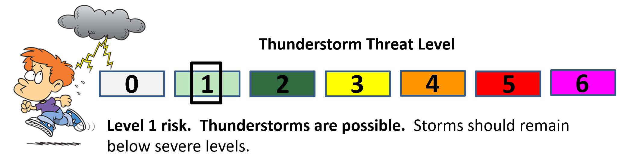
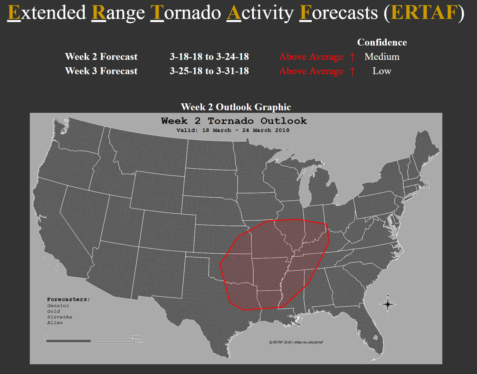
The experimental products issued by NIU show some risk of severe weather next week.
Learn more about this product as this link. Click here.
Forecast Discussion:
Our first areal outlook! Highlighted areas correspond to locations of greatest forecast tornado density. We are working to further objectify this meaning of this outline (e.g., the probability of exceeding the climatological probability of a tornado within 25 miles of a point), so stay tuned. AA conditions are expected during week two, despite the limited number of tornado days (e.g., the middle portion of week two appears quiet).
Analogs suggest an active week 3 period, and thus, we have opted to introduce AA conditions despite low confidence due to large uncertainty in the dynamic models.
Forecasters for the above graphic were: Allen, Gensini, Gold, Sirvatka
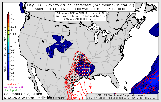
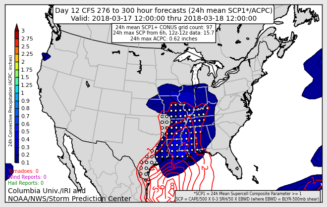
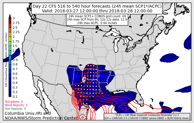
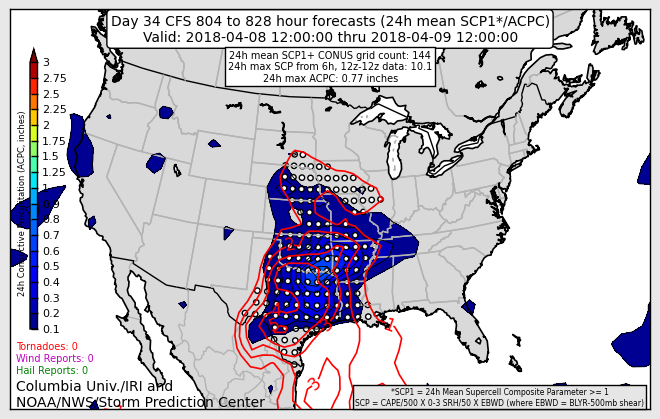
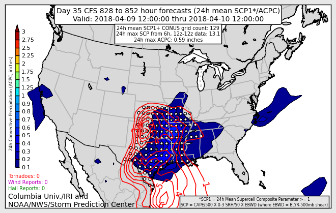
In addition to that, we are seeing some activity on the CFS long-range severe weather outlooks. You can view those here. Click here.
What do these graphics mean to you? These are long range graphics that attempt to figure out where thunderstorms could be strong or severe. Since they are in the long range the confidence is low. They are hit and miss with accuracy.
They are better used as a “signal” for the potential of thunderstorm activity. Long range graphics are always lower confidence.
These graphics tell me that we are entering that time of the year when we have to pay a bit more attention to the weather.
Can they change?
Yes! Definitely. The outlooks shift around daily as new/fresh data is ingested into the model.
If we are not in the outlined area does that mean we won’t have thunderstorms?
No, because the graphics change daily. As new data is ingested the graphics can change. What I look for is consistency day to day. If a day keeps showing a “hit” then confidence rises that we might have to deal with strong storms.
March 16th and 17th
March 17th and 18th
March 27th and 28th
April 7th and 8th
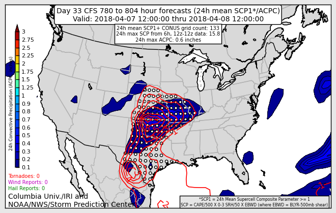
April 8th and 8th
April 9th and 10th

Weather Brains is a weekly podcast/video for those who love weather and want more!
Weather Brains episode number 633
Previous episodes can be viewed by clicking here.
t’s a full house for this episode of WeatherBrains with representatives from a number of weather-related podcasts. Joining us are Becky DePodwin, Ice Station Housman, Scotty Powell from Carolina Weather Gang, Castle Williams,
WeatherHype
, Mark Jelinek, What is it About the Weather, and Phil Johnson of Storm Front Freaks Podcast. This show marks National Weather Podcast Month.
Other discussions in this weekly podcast include topics like:
- Extremes: 98 at Rio Grande Village, TX, and -7 at Cut Bank, MT
- The creative outlet that is podcasts and how they have changed over time
- The importance of providing good content in podcasting
- 25th Anniversary of Blizzard of 1993
- Astronomy Outlook with Tony Rice
- and more!

We offer interactive local city live radars and regional radars. If a radar does not update then try another one. If a radar does not appear to be refreshing then hit Ctrl F5. You may also try restarting your browser.
The local city view radars also have clickable warnings.
During the winter months, you can track snow and ice by clicking the winterize button on the local city view interactive radars.
You may email me at beaudodson@usawx.com
Find me on Facebook!

Find me on Twitter!

Did you know that a portion of your monthly subscription helps support local charity projects?
You can learn more about those projects by visiting the Shadow Angel Foundation website and the Beau Dodson News website.

I encourage subscribers to use the app vs regular text messaging. We have found text messaging to be delayed during severe weather. The app typically will receive the messages instantly. I recommend people have three to four methods of receiving their severe weather information.
Remember, my app and text alerts are hand typed and not computer generated. You are being given personal attention during significant weather events.
