For $5 a month you can receive the following. You may choose to receive these via your WeatherTalk app or regular text messaging.
- Severe weather app/text alerts from my keyboard to your app/cell phone. These are hand typed by Beau. During tornado outbreaks, you will receive numerous app/text messages telling you exactly where the tornado is located.
- Daily forecast app/texts from my computer to your app/cell phone.
- Social media links sent directly to your app/cell phone. When I update the blog, videos, or Facebook you will receive the link.
- AWARE emails. These emails keep you well ahead of the storm. They give you several days of lead time before significant weather events.
- Direct access to Beau via text and email. Your very own personal meteorologist. I work for you!
- Missouri and Ohio Valley centered video updates
- Long-range weather videos
- Week one, two, three and four temperature and precipitation outlooks.
- Monthly outlooks.
- Your subscription also will help support several local charities.
Would you like to subscribe? Subscribe at www.beaudodsonweather.com

I encourage subscribers to use the app vs regular text messaging. We have found text messaging to be delayed during severe weather. The app typically will receive the messages instantly. I recommend people have three to four methods of receiving their severe weather information.
Remember, my app and text alerts are hand typed and not computer generated. You are being given my personal attention during significant weather events.

WWW.WEATHERTALK.COM subscribers, here is my day to day schedule for your weather products.


We offer interactive local city live radars and regional radars. If a radar does not update then try another one. If a radar does not appear to be refreshing then hit Ctrl F5. You may also try restarting your browser.

July 27, 2018
Friday Forecast Details
Forecast: Morning fog mixing out. Morning clouds and then becoming mostly sunny.
Temperatures: MO ~ 84 to 86 IL ~ 83 to 86 KY ~ 83 to 86 TN ~ 85 to 86
What is the chance of precipitation? MO ~ 0% IL ~ 0 KY ~ 10% TN ~ 0%
Coverage of precipitation: None
Wind: Variable winds at 5 to 10 mph with gusts to 15 mph
What impacts are anticipated from the weather? None
My confidence in the forecast verifying: High
Is severe weather expected? No
The NWS defines severe weather as 58 mph wind or great, 1″ hail or larger, and/or tornadoes
Should I cancel my outdoor plans? No
UV Index: 9 to 10 High
Sunrise: 5:55 AM
Friday Night Forecast Details:
Forecast: Partly cloudy. Cooler.
Temperatures: MO ~ 60 to 65 IL ~ 58 to 65 KY ~ 60 to 65 TN ~ 63 to 66
What is the chance of precipitation? MO ~ 0% IL ~ 0% KY ~ 0% TN ~ 0%
Coverage of precipitation: None
Wind: North and northeast at 4 to 8 mph
What impacts are anticipated from the weather? None
My confidence in the forecast verifying: High
Is severe weather expected? No
The NWS defines severe weather as 58 mph wind or great, 1″ hail or larger, and/or tornadoes
Should I cancel my outdoor plans? No
Sunset: 8:06 PM
Moonrise: 8:10 PM Full
Moonset: 5:39 AM
July 28, 2018
Saturday Forecast Details
Forecast: Mostly sunny. A few passing clouds. Mild temperatures. The NAM model guidance is showing an area of rain moving in from the west. This is the only model that shows this. I will keep an eye on it. For now, I have discounted the NAM model as being incorrect. It does, however, lower confidence just a bit on the Saturday forecast.
Temperatures: MO ~ 83 to 86 IL ~ 83 to 85 KY ~ 84 to 86 TN ~ 84 to 86
What is the chance of precipitation? MO ~ 20% IL ~ 20% KY ~ 10% TN ~ 10%
Coverage of precipitation: Most likely none. I will keep an eye on guidance trends.
Wind: Variable winds at 5 to 10 mph
What impacts are anticipated from the weather? Most likely none
My confidence in the forecast verifying: LOW
Is severe weather expected? No
The NWS defines severe weather as 58 mph wind or great, 1″ hail or larger, and/or tornadoes
Should I cancel my outdoor plans? No
UV Index: 9 to 10 High
Sunrise: 5:56 AM
Saturday Night Forecast Details:
Forecast: Cloudy. A scattered shower or thunderstorm possible.
Temperatures: MO ~ 64 to 68 IL ~ 63 to 66 KY ~ 64 to 68 TN ~ 65 to 68
What is the chance of precipitation? MO ~ 30% IL ~ 30% KY ~ 20% TN ~ 20%
Coverage of precipitation: Isolated to widely scattered
Wind: East at 5 to 10 mph becoming southeast at 4 to 8 mph
What impacts are anticipated from the weather? Isolated to widely scattered wet roadways and perhaps lightning.
My confidence in the forecast verifying: Medium
Is severe weather expected? No
The NWS defines severe weather as 58 mph wind or great, 1″ hail or larger, and/or tornadoes
Should I cancel my outdoor plans? No
Sunset: 8:05 PM
Moonrise: 8:48 PM Waning Gibbous
Moonset: 6:33 AM
July 29, 2018
Sunday Forecast Details
Forecast:
A mix of sun and clouds. Increasing clouds through the day. Scattered showers possible over mainly southeast Missouri and southwest Illinois. Not as warm (mainly because of some clouds). We will need to monitor the precipitation coverage.
Temperatures: MO ~ 80 to 85 IL ~ 80 to 85 KY ~ 84 to 86 TN ~ 84 to 86
What is the chance of precipitation? MO ~ 40% to 50% IL ~ 40% to 50% KY ~ 30% to 40% TN ~ 20% to 30%
Coverage of precipitation: Scattered
Wind: Becoming southeast at 5 to 10 mph
What impacts are anticipated from the weather? Wet roadways and perhaps isolated lightning.
My confidence in the forecast verifying: Medium
Is severe weather expected? No
The NWS defines severe weather as 58 mph wind or great, 1″ hail or larger, and/or tornadoes
Should I cancel my outdoor plans? Monitor radars and don’t cancel events. We will need to monitor the rain coverage. Some data shows a period of widespread rain. Other data does not agree.
UV Index: 6 to 8 Moderate (depending on your location vs the thicker cloud cover)
Sunrise: 5:56 AM
Sunday Night Forecast Details:
Forecast: Cloudy with scattered showers and perhaps a thunderstorm. Best chances over southeast Missouri and southern Illinois. Decreasing chances as you travel southeast.
Temperatures: MO ~ 64 to 68 IL ~ 64 to 68 KY ~ 64 to 68 TN ~ 66 to 68
What is the chance of precipitation? MO ~ 40% to 50% IL ~ 40% to 50% KY ~ 40% to 50% TN ~ 40% to 50%
Coverage of precipitation: Scattered
Wind: South and southeast at 5 to 10 mph
What impacts are anticipated from the weather? Wet roadways and lightning. Locally heavy rain where thunderstorms occur.
My confidence in the forecast verifying: Medium
Is severe weather expected? Unlikely, but monitor updates
The NWS defines severe weather as 58 mph wind or great, 1″ hail or larger, and/or tornadoes
Should I cancel my outdoor plans? Monitor updates. Rain is possible
Sunset: 8:04 PM
Moonrise: 9:54 PM Waning Gibbous
Moonset: 8:25 AM
July 30, 2018
Monday Forecast Details
Forecast: Mostly cloudy. Scattered showers and thunderstorms.
Temperatures: MO ~ 78 to 84 IL ~ 78 to 84 KY ~ 83 to 86 TN ~ 83 to 86
What is the chance of precipitation? MO ~ 50% to 60% IL ~ 50% to 60% KY ~ 40% to 50% TN ~ 40% to 50%
Coverage of precipitation: Scattered to perhaps numerous
Wind: East and southeast at 6 to 12 mph
What impacts are anticipated from the weather? Wet roadways and lightning. Locally heavy rain where thunderstorms occur.
My confidence in the forecast verifying: Medium
Is severe weather expected? Most likely no. A strong storm is possible, but most likely storms will remain below severe levels.
The NWS defines severe weather as 58 mph wind or great, 1″ hail or larger, and/or tornadoes
Should I cancel my outdoor plans? I would suggest monitoring radars and having a plan B
UV Index: 3 to 6 (clouds will cause the UV index to be lower)
Sunrise: 5:58 AM
Monday Night Forecast Details:
Forecast: Cloudy with showers and thunderstorms likely. Locally heavy rain possible.
Temperatures: MO ~ 63 to 66 IL ~ 63 to 66 KY ~ 64 to 68 TN ~ 66 to 68
What is the chance of precipitation? MO ~ 50% to 60% IL ~ 50% to 60% KY ~ 50% to 60% TN ~ 50% to 60%
Coverage of precipitation:Scattered to perhaps numerous
Wind: Becoming northeast at 5 to 10 mph
What impacts are anticipated from the weather? Wet roadways and lightning. Locally heavy rain where thunderstorms occur.
My confidence in the forecast verifying: Medium
Is severe weather expected? Unlikely, but monitor updates
The NWS defines severe weather as 58 mph wind or great, 1″ hail or larger, and/or tornadoes
Should I cancel my outdoor plans? Monitor updates. Rain is possible. Have a plan B.
Sunset: 8:04 PM
Moonrise: 9:53 PM Waning Gibbous
Moonset: 8:23 AM
July 31, 2018
Tuesday Forecast Details
Forecast: Partly to mostly cloudy. Scattered showers and thunderstorms. Rain tapering off during the afternoon hours.
Temperatures: MO ~ 82 to 85 IL ~ 80 to 85 KY ~ 80 to 85 TN ~ 83 to 85
What is the chance of precipitation? MO ~ 40% to 50% IL ~ 40% to 50% KY ~ 40% to 50% TN ~ 40% to 50%
Coverage of precipitation: Scattered
Wind: Variable becoming mostly northwest
What impacts are anticipated from the weather? Wet roadways and lightning. Locally heavy rain with any storms that form.
My confidence in the forecast verifying: Medium
Is severe weather expected? No
The NWS defines severe weather as 58 mph wind or great, 1″ hail or larger, and/or tornadoes
Should I cancel my outdoor plans? I would monitor radars and updates. Some rain will likely linger into Tuesday
UV Index: 4 to 6 Moderate
Sunrise: 5:59 AM
Tuesday Night Forecast Details:
Forecast: Some evening clouds. Showers and thunderstorms will likely have ended. A few may remain early in the night. If we clear out then fog may develop.
Temperatures: MO ~ 63 to 66 IL ~ 63 to 66 KY ~ 63 to 66 TN ~ 63 to 65
What is the chance of precipitation? MO ~10% IL ~ 20% KY ~ 20% TN ~ 10%
Coverage of precipitation: None to isolated. Ending.
Wind: North and norhtwest at 5 to 10 mph
What impacts are anticipated from the weather? Evening wet roadways and lightning. Fog possible overnight.
My confidence in the forecast verifying: Medium
Is severe weather expected? No
The NWS defines severe weather as 58 mph wind or great, 1″ hail or larger, and/or tornadoes
Should I cancel my outdoor plans? No, but check radars early in the night.
Sunset: 8:03 PM
Moonrise: 10:25 PM Waning Gibbous
Moonset: 9:21 AM
August 1, 2018
Wednesday Forecast Details
Forecast: Partly cloudy. Mild. Morning fog possible.
Temperatures: MO ~ 83 to 86 IL ~ 82 to 85 KY ~ 84 to 88 TN ~ 84 to 88
What is the chance of precipitation? MO ~ 10% IL ~ 10% KY ~ 20% TN ~ 20%
Coverage of precipitation: Most likely none
Wind: West and northwest at 6 to 12 mph
What impacts are anticipated from the weather? Perhaps morning low visibility if fog forms.
My confidence in the forecast verifying: Medium
Is severe weather expected? No
The NWS defines severe weather as 58 mph wind or great, 1″ hail or larger, and/or tornadoes
Should I cancel my outdoor plans? No
UV Index: 8 to 10 High
Sunrise: 5:59 AM
Wednesday Night Forecast Details:
Forecast: Mostly clear with a few passing clouds.
Temperatures: MO ~ 63 to 66 IL ~ 63 to 66 KY ~ 64 to 66 TN ~ 64 to 66
What is the chance of precipitation? MO ~ 0% IL ~ 0% KY ~ 0% TN ~ 0%
Coverage of precipitation: None
Wind: North and norhtwest at 5 to 10 mph
What impacts are anticipated from the weather? None
My confidence in the forecast verifying: Medium
Is severe weather expected? No
The NWS defines severe weather as 58 mph wind or great, 1″ hail or larger, and/or tornadoes
Should I cancel my outdoor plans? No
Sunset: 8:02 PM
Moonrise: 10:55 PM Waning Gibbous
Moonset: 10:21 AM
Learn more about the UV index readings. Click here.

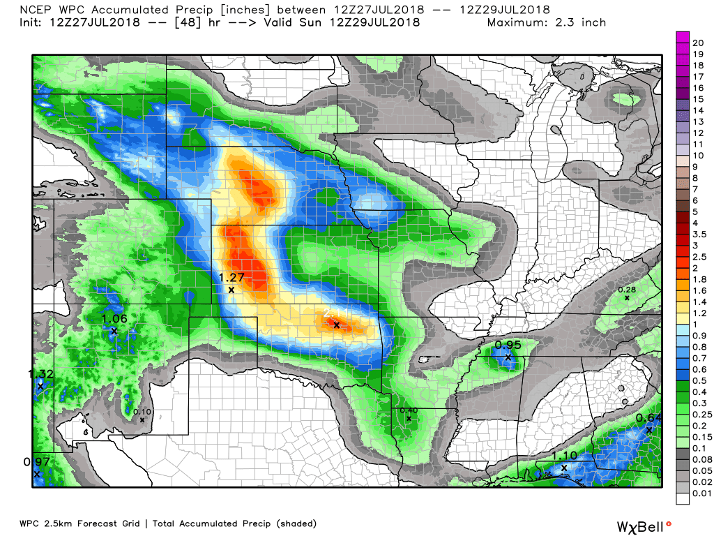
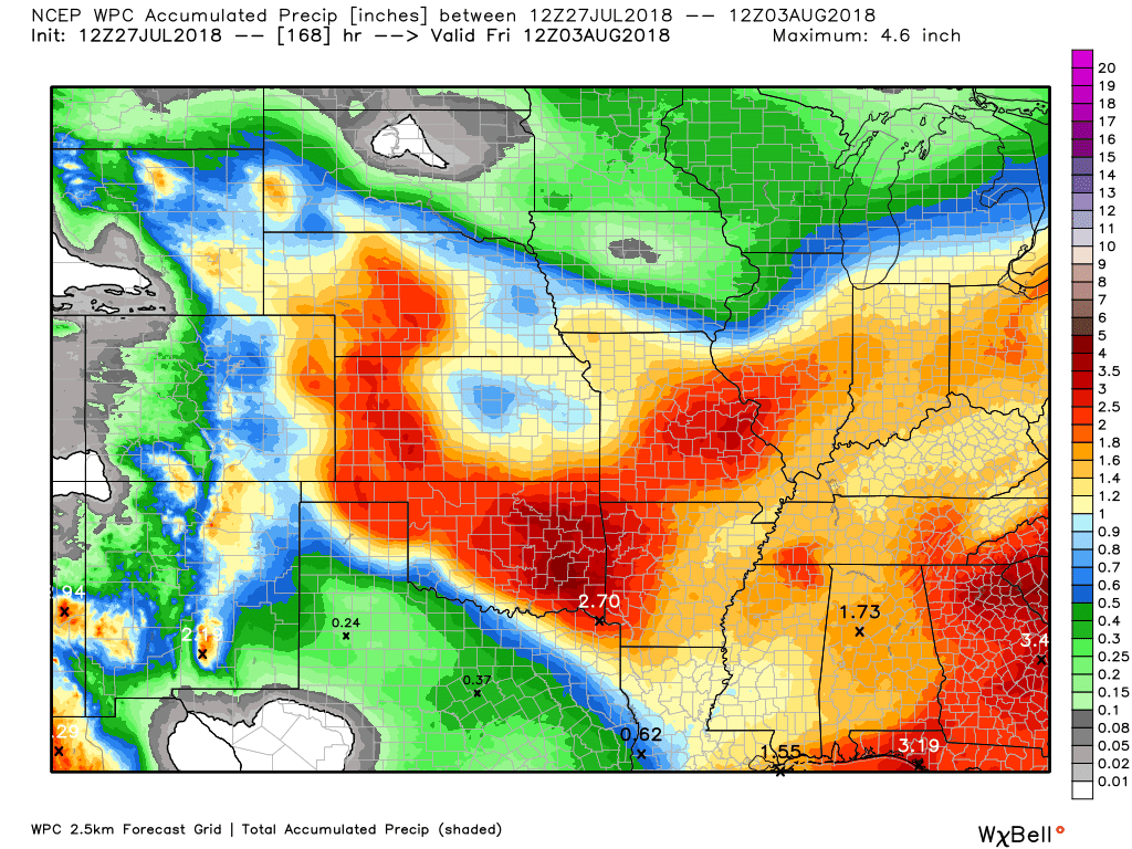
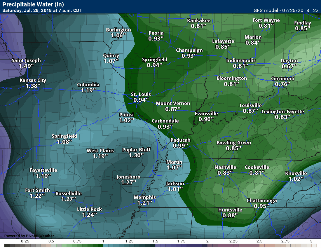
Here is the latest WPC / NOAA Rainfall charts
This graphic will not cover those wild swings in rainfall totals that occur from locally heavy thunderstorms. These number will be greatly underdone where slow moving thunderstorms occur.
This first graphic is the 3 day rainfall through Sunday 7 AM
Click to enlarge graphics on this page
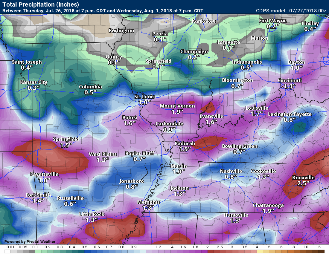
Here are the rain totals through next Friday morning
Most of this falls Sunday night into Tuesday morning
Click to enlarge
.

We offer interactive local city live radars and regional radars. If a radar does not update then try another one.
If a radar does not appear to be refreshing then hit Ctrl F5 on your keyboard.
You may also try restarting your browser.
The local city view radars also have clickable warnings.
During the winter months, you can track snow and ice by clicking the winterize button on the local city view interactive radars.

Questions? Broken links? Other questions?
You may email me at beaudodson@usawx.com

The National Weather Service defines a severe thunderstorm as one that produces quarter size hail or larger, 58 mph winds or greater, and/or a tornado.
ind with height and/or the increase of wind speed with height. This is one ingredient when forecasting severe thunderstorms.
Friday into Saturday afternoon: Severe weather is not anticipated. A small chance of a thunderstorm late Saturday afternoon over mainly southeast Missouri. Odds favor Saturday being dry across most of the area.
Saturday night through Tuesday: A cold front approaches the region Sunday night into Tuesday. This front will bump into warm and moist air. This will set the stage for several rounds of showers and thunderstorms.
At this time, the threat of severe weather appears small.
Isolated storms are possible Saturday night over mainly southeast Missouri and southern Illinois.
A few scattered thunderstorms are possible Sunday.
Thunderstorm chances increase Sunday night into Tuesday morning. Peak thunderstorm chances will likely be late Monday afternoon into early Tuesday morning.
Locally heavy rain will be a concern with PWAT values of 1.7 to 2.0″. That is a lot of moisture for storms to tap into. Remember, PWAT is a measure of moisture in the entire atmosphere.
Summer thunderstorms can produce isolated microbursts.
microburst winds can exceed 50 mph.
What are microbursts?

Interactive live weather radar page. Choose the city nearest your location. If one of the cities does not work then try a nearby one. Click here.
National map of weather watches and warnings. Click here.
Storm Prediction Center. Click here.
Weather Prediction Center. Click here.

Live lightning data: Click here.

Interactive GOES R satellite. Track clouds. Click here.

Here are the latest local river stage forecast numbers Click Here.
Here are the latest lake stage forecast numbers for Kentucky Lake and Lake Barkley Click Here.

The summer outlook have been posted for subscribers. Scroll down to see the outlook.Not a subscriber? Learn more at this link.

Weather Headlines
- Vacation
- A decent Friday into Saturday on tap for the region
- Mostly dry weekend now anticipated (I am monitoring shower chances Saturday night into Sunday)
- Rain chances begin to slowly ramp up Sunday afternoon and night
- Rain chances increase considerably Monday into Tuesday
- Locally heavy rain with high PWAT values
I am on vacation with family this week.
Forecast overview:
A decent day on tap for the region. We are waking up to some patchy dense fog across portions of the region. This fog will mix out as the morning wears on. Mixing out means dissipating or lifting.
Dry conditions are anticipated across the region into Saturday afternoon.
The NAM model guidance is showing widespread rain Saturday. The rain moves in from the west. This is the only model that shows this scenario. I will keep an eye on it. For now, I am discounting it.
Temperatures will be mild. As a matter of fact, a few locations may dip into the upper 50’s Friday night. This would most likely be across portions of southern Illinois and northwest Kentucky. That will feel nice!
A warm front will lift northward through the region on Sunday. This front will help produce a few showers and thunderstorms across mainly southeast Missouri and southern Illinois.
Much of the region should remain dry through Sunday afternoon. A few spots will pick up a shower Saturday night and Sunday. The best chance of that would be across southeast Missouri and southern Illinois.
I will keep an eye on the Sunday forecast. I will be monitoring the position of a warm front. That would help trigger a few areas of precipitation.
If you have outdoor plans over the weekend then I would move forward with them.
Rain chances increase as we move into Sunday night through Tuesday. This will be in response to an area of low pressure that will form to our southeast. It will move northeast and help produce numerous showers and locally heavy thunderstorms.
The peak of the rain chances will be late Monday afternoon into Tuesday morning. This is when the front will push eastward and clear the region.
Moisture will pull ahead of the cold front. That means locally heavy rain totals. PWAT values will be on the high side.
Here are three different models. Each show the anticipated rainfall totals through Monday night.
NAM
Click to enlarge images on this page
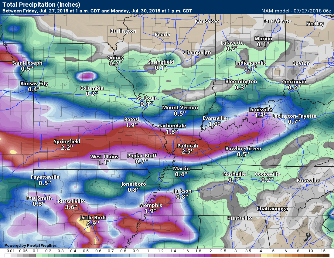
GFS
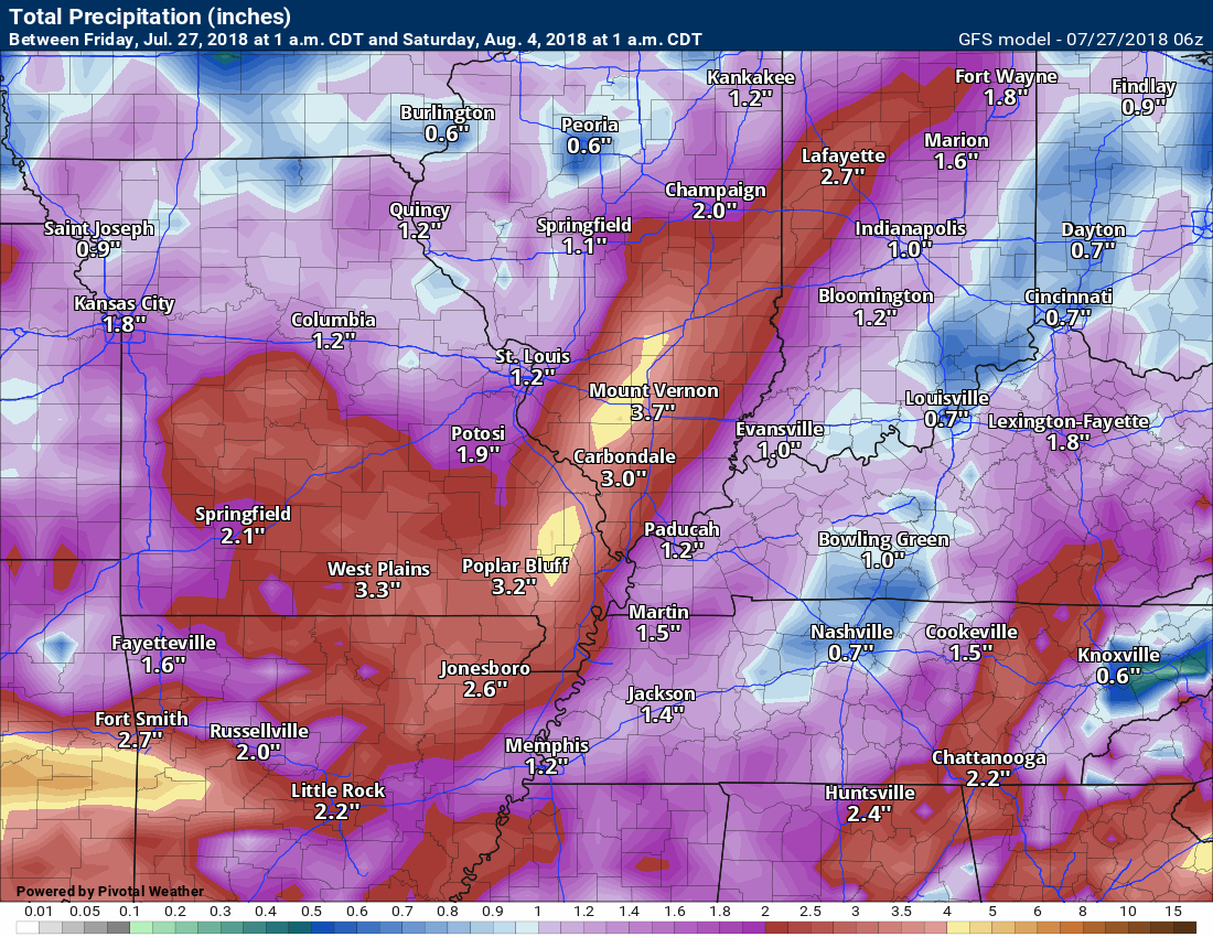
GEM
PWAT is a measure of moisture in the entire atmospheric column.
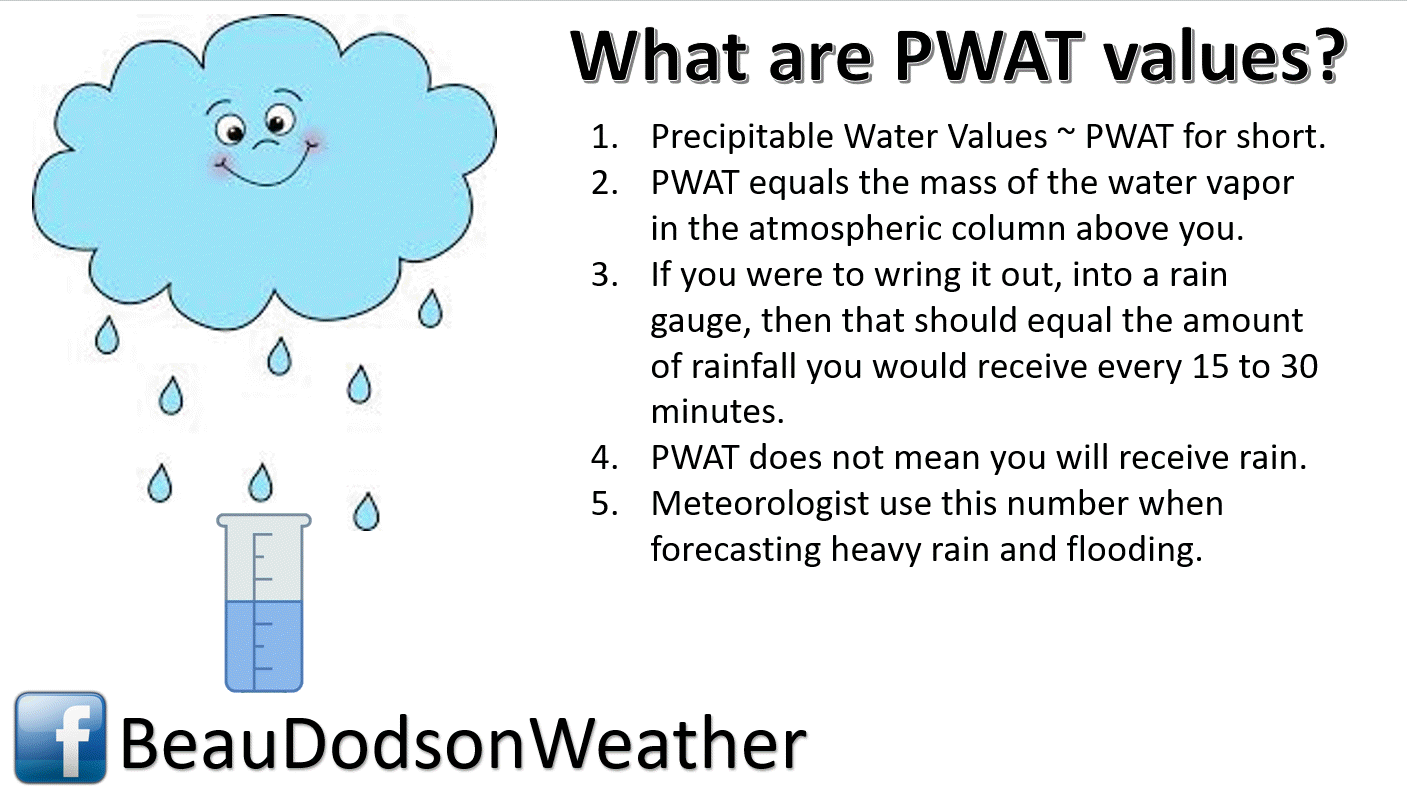
Here is the NAM model PWAT value animation. These are PWAT values. I anticipate PWAT values of 1.7 to 2.0 Sunday into Tuesday morning.
You can see how it pools ahead of the cold front. PWAT values rapidly decrease rapidly after the cold front passes.
The pooling of high PWAT values are an indication of locally heavy rain.
Time stamp upper left.
We should dry out by Tuesday night and Wednesday. Perhaps a few remaining showers.
The August forecast has been updated.
Outlook definitions
EQ = Equal chances of above or below normal
BN= Below normal
M/BN = Much below normal
AN = Above normal
M/AN = Much above normal
E/AN = Extremely above normal.
These are bonus videos and maps for subscribers.
Subscribe at www.weathertalk.com
NOTE: THESE ARE USUALLY NOT UPDATED ON SATURDAY OR SUNDAY.

These videos are a bonus for subscribers.
This one is centered on the Ohio Valley.
Keep in mind that this covers a larger region than just our local counties.
These videos are for subscribers.
Subscribe at www.weathertalk.com
Illinois/Ohio Valley Video Update

These videos are for subscribers.
Subscribe at www.weathertalk.com
Long Range Video (more technical discussion)

These videos are for subscribers.
Subscribe at www.weathertalk.com
Missouri Valley and Central Plains

I bring these to you from the BAMwx team. They are excellent long-range forecasters.
Remember, long-range outlooks are a bit of skill, understanding weather patterns, and luck combined. It is not an exact science.

Outlook definitions
EQ = Equal chances of above or below normal
BN= Below normal
M/BN = Much below normal
AN = Above normal
M/AN = Much above normal
E/AN = Extremely above normal.
Normal high temperatures for this time of the year are around 92 degrees.
Normal low temperatures for this time of the year are around 69 degrees.
Normal precipitation during this time period ranges from 0.25″ to 0.50″
This outlook covers July 24th through July 30th
These graphics are for subscribers.
Subscribe at www.weathertalk.com
The precipitation forecast is PERCENT OF NORMAL. For example, if your normal rainfall is 1.00″ and the graphic shows 10%, then that would mean 0.10″ of rain is anticipated.
Always keep in mind, slow moving summer thunderstorms can produce torrential rain. That could skew the rainfall outlook.
These graphics are for subscribers.
Subscribe at www.weathertalk.com

These graphics are for subscribers.
The precipitation forecast is PERCENT OF NORMAL. For example, if your normal rainfall is 1.00″ and the graphic shows 10%, then that would mean 0.10″ of rain is anticipated.
These graphics are for subscribers.
Subscribe at www.weathertalk.com

These graphics are for subscribers.
Subscribe at www.weathertalk.com
And precipitation
These graphics are for subscribers.
Subscribe at www.weathertalk.com
Temperature outlook for June through August.
These graphics are for subscribers.
Subscribe at www.weathertalk.com
July temperature and precipitation outlook
These graphics are for subscribers.
Subscribe at www.weathertalk.com
August temperature and precipitation outlook
These graphics are for subscribers.
Subscribe at www.weathertalk.com
![]()

A new weather podcast is now available! Weather Geeks (which you might remember is on The Weather Channel each Sunday)
To learn more visit their website. Click here.
![]()

WeatherBrains Episode 652
Tonight’s Guest WeatherBrain is a meteorologist at the Naval Research Laboratory. Dr. David Peterson, welcome to WeatherBrains!
Last year was a record year for wildfires across the globe, and their impact on the atmosphere remains highly uncertain. Thanks to new research from expert scientists at the U.S. Naval Research Laboratory, the world is gaining more insight into what drives these massive and escalating events. NRL meteorologist Dr. Peterson explained his findings from his recent research, “Wildfire-Driven Thunderstorms Cause a Volcano-Like Stratospheric Injection of Smoke,” during a press conference at the European Geosciences Union’s annual General Assembly in Vienna, Austria, held from April 8 to 13. “Our research shows that the stratospheric impact from five wildfire-driven thunderstorms, known as pyrocumulonimbus or pyroCb, was comparable to a moderate volcanic eruption,” Peterson explained the NRL pryoCb research team’s findings and that it’s an interdisciplinary collaboration with scientists from both the Marine Meteorology and Remote Sensing Divisions within NRL. The significance of volcanic eruptions in the climate system has been recognized for several decades, but pyroCb research is relatively new, originating at NRL in the early 2000s, according to Peterson.
Other discussions in this weekly podcast include topics like:
- Extremes: 120 at Death Valley, CA, and 41 at Naples, ID
- NASA Sponsored Joint Korea/US Air Quality Campaign
- Birmingham reached 105F on this date in 1980
- Tropics all quiet in Atlantic basin
- Astronomy Outlook with Tony Rice
- and more!
Link https://weatherbrains.com/
Previous episodes can be viewed by clicking here.
We offer interactive local city live radars and regional radars. If a radar does not update then try another one. If a radar does not appear to be refreshing then hit Ctrl F5. You may also try restarting your browser.
The local city view radars also have clickable warnings.
During the winter months, you can track snow and ice by clicking the winterize button on the local city view interactive radars.
You may email me at beaudodson@usawx.com
Find me on Facebook!

Find me on Twitter!

Did you know that a portion of your monthly subscription helps support local charity projects?
You can learn more about those projects by visiting the Shadow Angel Foundation website and the Beau Dodson News website.

I encourage subscribers to use the app vs regular text messaging. We have found text messaging to be delayed during severe weather. The app typically will receive the messages instantly. I recommend people have three to four methods of receiving their severe weather information.
Remember, my app and text alerts are hand typed and not computer generated. You are being given personal attention during significant weather events.
