1 PM Update
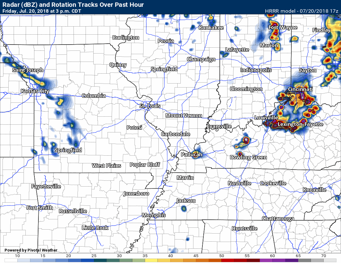
Interesting to note that the latest Hrrr model now shows no storms forming today. There is a CAP on the atmosphere. We will have to see if that CAP breaks. Occasionally, these types of events don’t occur because of the CAP.
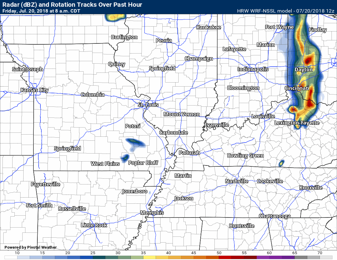
9 AM update
The latest high resolution WRF model shows storms forming early in the afternoon.
Click to enlarge the animation. Time stamp upper left.
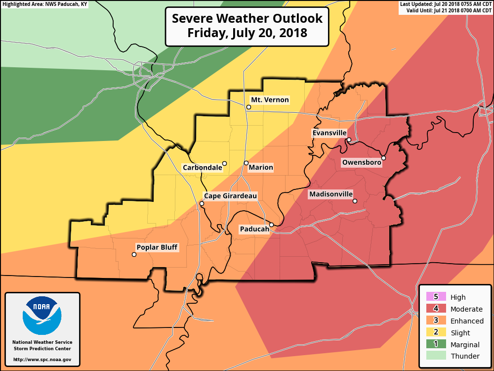
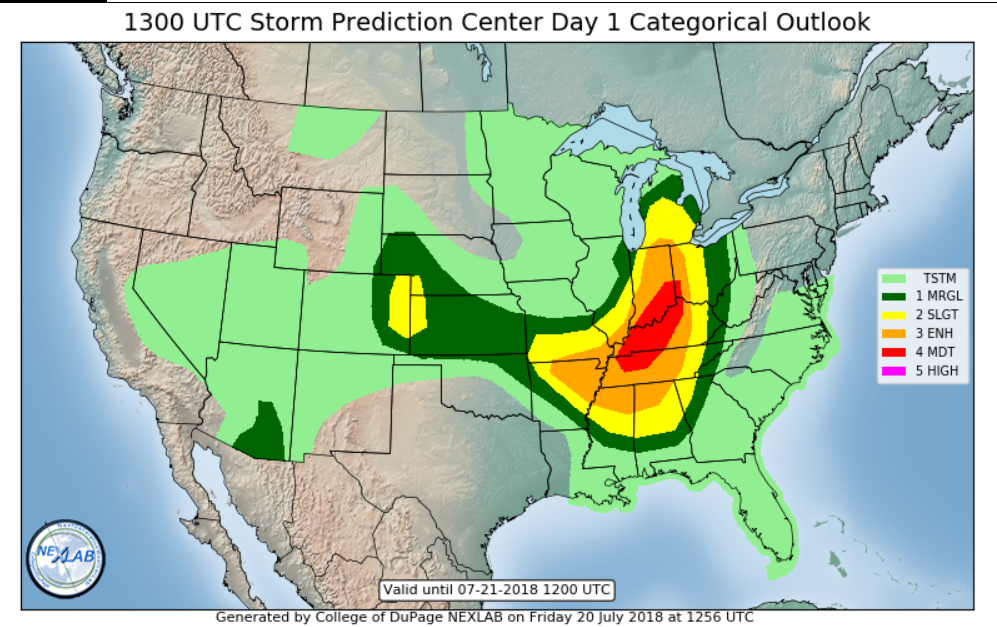
The latest Storm Prediction Center severe weather outlook
Dark green is a level one risk (the lowest). The orange and red are the higher risk zones. Don’t get too caught up on the exact placement of the colors. Weather does not always follow our man-made lines.
Be alert today
The blog is free for everyone today.
If you are not a subscriber, please consider becoming one.
We are now offering up to SEVEN phones for $5.00.
For $5 a month you can receive the following. You may choose to receive these via your WeatherTalk app or regular text messaging.
- Severe weather app/text alerts from my keyboard to your app/cell phone. These are hand typed by Beau. During tornado outbreaks, you will receive numerous app/text messages telling you exactly where the tornado is located.
- Daily forecast app/texts from my computer to your app/cell phone.
- Social media links sent directly to your app/cell phone. When I update the blog, videos, or Facebook you will receive the link.
- AWARE emails. These emails keep you well ahead of the storm. They give you several days of lead time before significant weather events.
- Direct access to Beau via text and email. Your very own personal meteorologist. I work for you!
- Missouri and Ohio Valley centered video updates
- Long-range weather videos
- Week one, two, three and four temperature and precipitation outlooks.
- Monthly outlooks.
- Your subscription also will help support several local charities.
Haven’t you subscribed? Subscribe at www.beaudodsonweather.com

I encourage subscribers to use the app vs regular text messaging. We have found text messaging to be delayed during severe weather. The app typically will receive the messages instantly. I recommend people have three to four methods of receiving their severe weather information.
Remember, my app and text alerts are hand typed and not computer generated. You are being given my personal attention during significant weather events.

WWW.WEATHERTALK.COM subscribers, here is my day to day schedule for your weather products.

We offer interactive local city live radars and regional radars. If a radar does not update then try another one. If a radar does not appear to be refreshing then hit Ctrl F5. You may also try restarting your browser.

Interactive Radars:
Interactive live weather radar page. Choose the city nearest your location. If one of the city radars won’t load then try a nearby one. Click here.
July 20, 2018
Friday Forecast Details
Forecast: Partly cloudy. Hot and muggy. Scattered thunderstorms. A few storms will be severe.
Temperatures: MO ~ 92 to 96 IL ~ 88 to 94 KY ~ 88 to 94 TN ~ 88 to 94
What is the chance of precipitation? MO ~ 30% to 40% IL ~ 40% KY ~ 60% TN ~ 60%
Coverage of precipitation: Scattered to perhaps numerous
Wind: Southwest at 5 to 10 mph with gusts to 18 mph
What impacts are anticipated from the weather? Wet roadways and lightning. Severe storms likely. Large hail. Pockets of wind damage. There is some risk of tornadoes if storms form. Heavy downpours.
My confidence in the forecast verifying: High
Is severe weather expected? Yes, there is a risk of severe thunderstorm.
The NWS defines severe weather as 58 mph wind or great, 1″ hail or larger, and/or tornadoes
Should I cancel my outdoor plans? Monitor radars and updates. Severe storms are likely.
UV Index: 8 to 9 High
Sunrise: 5:50 AM
Friday Night Forecast Details:
Forecast: Partly cloudy. Scattered thunderstorms. Some storms will be severe early in the night. Thunderstorm activity will be most likely across our southern counties. Activity will end north to south through the evening.
Temperatures: MO ~ 66 to 72 IL ~ 66 to 72 KY ~ 66 to 72 TN ~ 66 to 72
What is the chance of precipitation? MO ~ 30% IL ~ 30% to 40% KY ~ 60% TN ~ 60%
Coverage of precipitation: Scattered to perhaps numerous. Low confidence on coverage.
Wind: West and northwest at 5 to 10 mph
What impacts are anticipated from the weather? Wet roadways and lightning. Heavy rain where storms occur. Some storms will be severe with hail and high wind. Tornadoes are also possible this evening.
My confidence in the forecast verifying: Medium
Is severe weather expected? Yes, severe storms are likely in the region (mainly during the evening hours)
The NWS defines severe weather as 58 mph wind or great, 1″ hail or larger, and/or tornadoes
Should I cancel my outdoor plans? Monitor updates and radars. Storms are likely over at least the southern half of the region. Ending from north to south as we move into the overnight hours.
Sunset: 8:12 PM
Moonrise: 2:06 PM First quarter
Moonset: 12:48 AM
July 21, 2018
Saturday Forecast Details
Forecast: Mostly sunny. A few clouds. Most of the thunderstorms should have ended. Warm. Isolated thunderstorms possible.
Temperatures: MO ~ 86 to 90 IL ~ 86 to 90 KY ~ 86 to 92 TN ~ 86 to 92
What is the chance of precipitation? MO ~ 10% IL ~ 10% to 20% KY ~ 20% TN ~ 20%
Coverage of precipitation: I can’t rule out some storms over mainly southeast Illinois and the Pennyrile area of western Kentucky
Wind: Northwest at 5 to 10 mph with gusts to 14 mph
What impacts are anticipated from the weather? Isolated wet roadways and lightning.
My confidence in the forecast verifying: High
Is severe weather expected? No
The NWS defines severe weather as 58 mph wind or great, 1″ hail or larger, and/or tornadoes
Should I cancel my outdoor plans? No
UV Index: 9 to 10 High
Sunrise: 5:50 AM
Saturday Night Forecast Details:
Forecast: Mostly clear. Mild. A few clouds over southeast Illinois and western Kentucky. Isolated storms possible across southeast Illinois and mainly the Pennyrile area of western Kentucky.
Temperatures: MO ~ 65 to 70 IL ~ 65 to 70 KY ~ 65 to 70 TN ~ 65 to 70
What is the chance of precipitation? MO ~ 5% IL ~ 20% KY ~ 20% TN ~ 20%
Coverage of precipitation: None to isolated
Wind: North and northwest at 5 to 10 mph with gusts to 15 mph
What impacts are anticipated from the weather? None to perhaps wet roadways and lightning.
My confidence in the forecast verifying: High
Is severe weather expected? No
The NWS defines severe weather as 58 mph wind or great, 1″ hail or larger, and/or tornadoes
Should I cancel my outdoor plans? No
Sunset: 8:13 PM
Moonrise: 3:06 PM Waxing Gibbous
Moonset: 1:21 AM
July 22, 2018
Sunday Forecast Details
Forecast: Mostly sunny over southeast Missouri with a mix of sun and clouds elsewhere. Warm. Widely scattered thunderstorms.
Temperatures: MO ~ 86 to 90 IL ~ 82 to 86 KY ~ 84 to 88 TN ~ 85 to 90
What is the chance of precipitation? MO ~ 20% IL ~ 30% KY ~ 30% to 40% TN ~ 20%
Coverage of precipitation: Widely scattered
Wind: Northwest at 7 to 14 mph with gusts to 20 mph
What impacts are anticipated from the weather? Wet roadways. Lightning.
My confidence in the forecast verifying: Medium
Is severe weather expected? Unlikely
The NWS defines severe weather as 58 mph wind or great, 1″ hail or larger, and/or tornadoes
Should I cancel my outdoor plans? No, but check radars. Some storms are possible
UV Index: 7 to 10 High (highest over southeast Missouri and lower over southeast Illinois and eastern parts of west Kentucky
Sunrise: 5:51 AM
Sunday Night Forecast Details:
Forecast: Partly cloudy. Mild. Isolated thunderstorms possible early.
Temperatures: MO ~ 66 to 70 IL ~ 64 to 68 KY ~ 64 to 68 TN ~ 65 to 70
What is the chance of precipitation? MO ~ 10% IL ~ 20% KY ~ 20% TN ~ 20%
Coverage of precipitation: Isolated to widely scattered
Wind: North at 3 to 6 mph with gusts to 14 mph
What impacts are anticipated from the weather? Isolated to widely scattered wet roadways and lightning (mainly early)
My confidence in the forecast verifying: Medium
Is severe weather expected? No
The NWS defines severe weather as 58 mph wind or great, 1″ hail or larger, and/or tornadoes
Should I cancel my outdoor plans? No, but perhaps check the radars during the evening hours
Sunset: 8:10 PM
Moonrise: 4:03 PM Waxing Gibbous
Moonset: 1:56 AM
July 23, 2018
Monday Forecast Details
Forecast: Partly to mostly sunny. A chance of widely scattered thunderstorms (mainly during the afternoon hours)
Temperatures: MO ~ 85 to 90 IL ~ 83 to 86 KY ~ 85 to 88 TN ~ 86 to 88
What is the chance of precipitation? MO ~ 10% IL ~ 20% KY ~ 20% TN ~ 10%
Coverage of precipitation: Isolated to widely scattered
Wind: North and northeast at 7 to 14 mph
What impacts are anticipated from the weather? A few wet roadways and lightning.
My confidence in the forecast verifying: Medium
Is severe weather expected? No
The NWS defines severe weather as 58 mph wind or great, 1″ hail or larger, and/or tornadoes
Should I cancel my outdoor plans? No, but check radars
UV Index: 9 to 10 High
Sunrise: 5:52 AM
Monday Night Forecast Details:
Forecast: Mostly clear with a few clouds. An isolated evening storm possible.
Temperatures: MO ~ 66 to 72 IL ~ 64 to 68 KY ~ 65 to 68 TN ~ 65 to 68
What is the chance of precipitation? MO ~ 10% IL ~ 20% KY ~ 20% TN ~ 20%
Coverage of precipitation: None to isolated
Wind: North at 3 to 6 mph
What impacts are anticipated from the weather? Isolated wet roadways and lightning.
My confidence in the forecast verifying: Medium
Is severe weather expected? No
The NWS defines severe weather as 58 mph wind or great, 1″ hail or larger, and/or tornadoes
Should I cancel my outdoor plans? No, but check radars
Sunset: 8:10 PM
Moonrise: 4:59 PM Waxing Gibbous
Moonset: 2:33 AM
July 24, 2018
Tuesday Forecast Details
Forecast: Partly sunny. Warm. Isolated to widely scattered thunderstorms.
Temperatures: MO ~ 85 to 90 IL ~ 83 to 86 KY ~ 85 to 88 TN ~ 86 to 88
What is the chance of precipitation? MO ~ 20% IL ~ 20% KY ~ 20% TN ~ 20%
Coverage of precipitation: Isolated to widely scattered
Wind: North and northeast at 6 to 12 mph
What impacts are anticipated from the weather? Wet roadways. Lightning.
My confidence in the forecast verifying: Medium
Is severe weather expected? Not at this time
The NWS defines severe weather as 58 mph wind or great, 1″ hail or larger, and/or tornadoes
Should I cancel my outdoor plans? No, but check radars
UV Index: 9 to 10 High
Sunrise: 5:53 AM
Tuesday Night Forecast Details:
Forecast: Partly cloudy. An isolated evening thunderstorm possible.
Temperatures: MO ~ 66 to 72 IL ~ 64 to 68 KY ~ 65 to 68 TN ~ 65 to 68
What is the chance of precipitation? MO ~ 10% IL ~ 10% KY ~ 10% TN ~ 10%
Coverage of precipitation: None to isolated
Wind: Northeast at 5 to 10 mph
What impacts are anticipated from the weather? None to perhaps a few wet roadways and lightning
My confidence in the forecast verifying: Medium
Is severe weather expected? Not at this time
The NWS defines severe weather as 58 mph wind or great, 1″ hail or larger, and/or tornadoes
Should I cancel my outdoor plans? No
Sunset: 8:09 PM
Moonrise: 5:52 PM Waxing Gibbous
Moonset: 3:14 AM
July 25, 2018
Wednesday Forecast Details
Forecast: Mostly sunny to partly cloudy. Widely scattered thunderstorms possible.
Temperatures: MO ~ 85 to 90 IL ~ 85 to 90 KY ~ 85 to 90 TN ~ 85 to 90
What is the chance of precipitation? MO ~ 20% IL ~ 20% KY ~ 30% TN ~ 30%
Coverage of precipitation: Widely scattered
Wind: North and northeast at 5 to 10 mph
What impacts are anticipated from the weather? Wet roadways. Lightning.
My confidence in the forecast verifying: LOW
Is severe weather expected? No
The NWS defines severe weather as 58 mph wind or great, 1″ hail or larger, and/or tornadoes
Should I cancel my outdoor plans? No
UV Index: 9 to 10 High
Sunrise: 5:54 AM
Wednesday Night Forecast Details:
Forecast: Partly cloudy. Widely scattered thunderstorms again possible.
Temperatures: MO ~ 66 to 72 IL ~ 66 to 70 KY ~ 66 to 70 TN ~ 66 to 70
What is the chance of precipitation? MO ~ 20% IL ~ 20% KY ~ 20% TN ~ 20%
Coverage of precipitation: Widely scattered
Wind: Northeast at 5 to 10 mph
What impacts are anticipated from the weather? Wet roadways and lightning.
My confidence in the forecast verifying: LOW
Is severe weather expected? No
The NWS defines severe weather as 58 mph wind or great, 1″ hail or larger, and/or tornadoes
Should I cancel my outdoor plans? No, but check radars
Sunset: 8:08 PM
Moonrise: 6:42 PM Waxing Gibbous
Moonset: 3:59 AM
July 26, 2018
Thursday Forecast Details
Forecast: Mostly sunny.
Temperatures: MO ~ 84 to 88 IL ~ 84 to 88 KY ~ 84 to 88 TN ~ 84 to 88
What is the chance of precipitation? MO ~ 0% IL ~ 0% KY ~ 0% TN ~ 0%
Coverage of precipitation: Most likely none
Wind:
What impacts are anticipated from the weather? Most likely none
My confidence in the forecast verifying: LOW
Is severe weather expected? No
The NWS defines severe weather as 58 mph wind or great, 1″ hail or larger, and/or tornadoes
Should I cancel my outdoor plans? No
UV Index: 9 to 10 High
Sunrise: 5:54 AM
Thursday Night Forecast Details:
Forecast: Mostly clear.
Temperatures: MO ~ 63 to 66 IL ~ 63 to 66 KY ~ 63 to 66 TN ~ 63 to 66
What is the chance of precipitation? MO ~ 0% IL ~ 0% KY ~ 0% TN ~ 0%
Coverage of precipitation: Most likely none
Wind:
What impacts are anticipated from the weather? Most likely none
My confidence in the forecast verifying: LOW
Is severe weather expected? No
The NWS defines severe weather as 58 mph wind or great, 1″ hail or larger, and/or tornadoes
Should I cancel my outdoor plans? No
Sunset: 8:07 PM
Moonrise: 7:28 PM Waxing Gibbous
Moonset: 4:47 AM
July 27, 2018
Friday Forecast Details
Forecast: Mostly sunny.
Temperatures: MO ~ 84 to 88 IL ~ 84 to 88 KY ~ 84 to 88 TN ~ 84 to 88
What is the chance of precipitation? MO ~ 0% IL ~ 0% KY ~ 0% TN ~ 0%
Coverage of precipitation: Most likely none
Wind:
What impacts are anticipated from the weather? Most likely none
My confidence in the forecast verifying: LOW
Is severe weather expected? No
The NWS defines severe weather as 58 mph wind or great, 1″ hail or larger, and/or tornadoes
Should I cancel my outdoor plans? No
UV Index: 9 to 10 High
Sunrise: 5:55 AM
Friday Night Forecast Details:
Forecast: Mostly clear.
Temperatures: MO ~ 63 to 66 IL ~ 63 to 66 KY ~ 63 to 66 TN ~ 63 to 66
What is the chance of precipitation? MO ~ 0% IL ~ 0% KY ~ 0% TN ~ 0%
Coverage of precipitation: Most likely none
Wind:
What impacts are anticipated from the weather? Most likely none
My confidence in the forecast verifying: LOW
Is severe weather expected? No
The NWS defines severe weather as 58 mph wind or great, 1″ hail or larger, and/or tornadoes
Should I cancel my outdoor plans? No
Sunset: 8:06 PM
Moonrise: 8:10 PM Waxing Gibbous
Moonset: 5:39 AM
Learn more about the UV index readings. Click here.

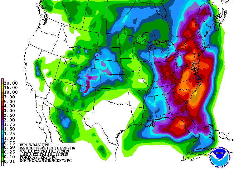
Here is the latest WPC / NOAA Rainfall charts
This graphic will not cover those wild swings in rainfall totals that occur from locally heavy thunderstorms. These number will be greatly underdone where slow moving thunderstorms occur.
This is the seven-day rainfall map (below)
Here are the rain totals through next Friday morning
** Again, thunderstorms can produce much higher totals. Keep that in mind **
.

We offer interactive local city live radars and regional radars. If a radar does not update then try another one.
If a radar does not appear to be refreshing then hit Ctrl F5 on your keyboard.
You may also try restarting your browser.
The local city view radars also have clickable warnings.
During the winter months, you can track snow and ice by clicking the winterize button on the local city view interactive radars.

Questions? Broken links? Other questions?
You may email me at beaudodson@usawx.com

The National Weather Service defines a severe thunderstorm as one that produces quarter size hail or larger, 58 mph winds or greater, and/or a tornado.
Friday into Friday night:
We do have some concern today for severe weather.
There remain questions on exact placement and timing of the severe weather.
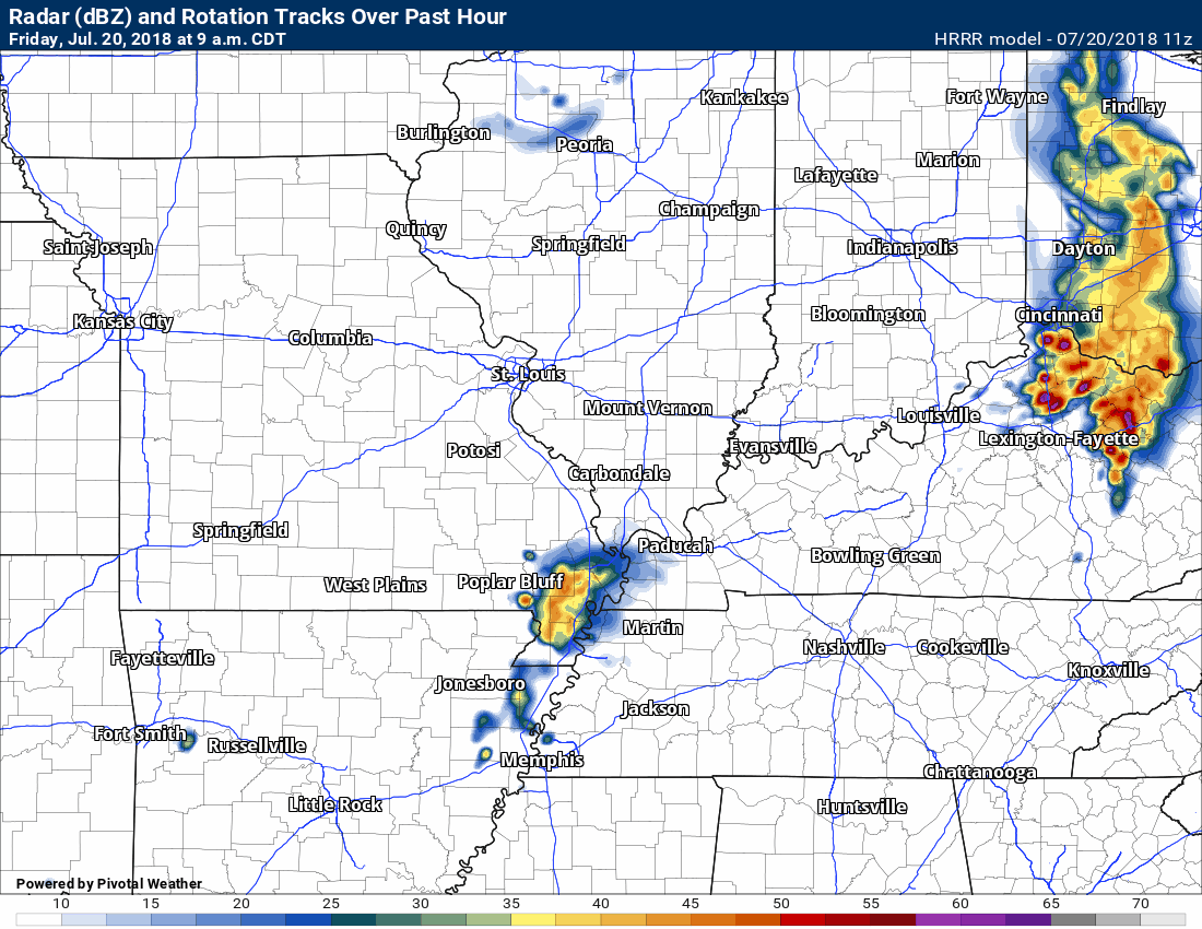
Thunderstorms have developed this morning in southeast Missouri and this is causing additional questions concerning this afternoons thunderstorms.
If we have more clouds then instability won’t be nearly as great. Lower instability would tend to lessen the severe weather risk.
If the atmosphere does become unstable then the stage is set for all modes of severe weather.
Supercell thunderstorms are possible today. Those type of storms are more widely scattered and can tap into the CAPE (energy).
I recommend you stay informed on the latest weather information. Questions remain about the actual extent of the severe weather risk.
There will be an abnormal amount of wind shear today into tonight. Wind shear is the turning of wind with height and/or the increase of wind speed with height. This is one ingredient when forecasting severe thunderstorms.
Saturday through Wednesday: For the time being it appears that severe thunderstorm chances will be low. There will be at least a daily chance of widely scattered thunderstorms in the region. Lightning would be the primary concern.
Summer thunderstorms can produce isolated microbursts.
microburst winds can exceed 50 mph.
What are microbursts?

Interactive live weather radar page. Choose the city nearest your location. If one of the cities does not work then try a nearby one. Click here.
National map of weather watches and warnings. Click here.
Storm Prediction Center. Click here.
Weather Prediction Center. Click here.

Live lightning data: Click here.

Interactive GOES R satellite. Track clouds. Click here.

Here are the latest local river stage forecast numbers Click Here.
Here are the latest lake stage forecast numbers for Kentucky Lake and Lake Barkley Click Here.

The summer outlook have been posted for subscribers. Scroll down to see the outlook.Not a subscriber? Learn more at this link.

Weather Headlines
- Some severe thunderstorms are anticipated today
- Unstable atmosphere could lead to several reports of large hail, damaging wind, frequent lightning, heavy downpours, and even tornadoes
- Weekend forecast is warm and humid
- We will have to deal with daily mainly heat of the day storms into next week
I will be sending out app/text messages today.
Make sure you have the tornado alert turned on. That would be app/text option number one. WeatherOne is its name.
You can find that within your www.weathertalk.com account under personal notification settings (remember, this is for paid accounts)
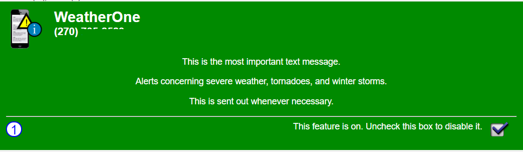
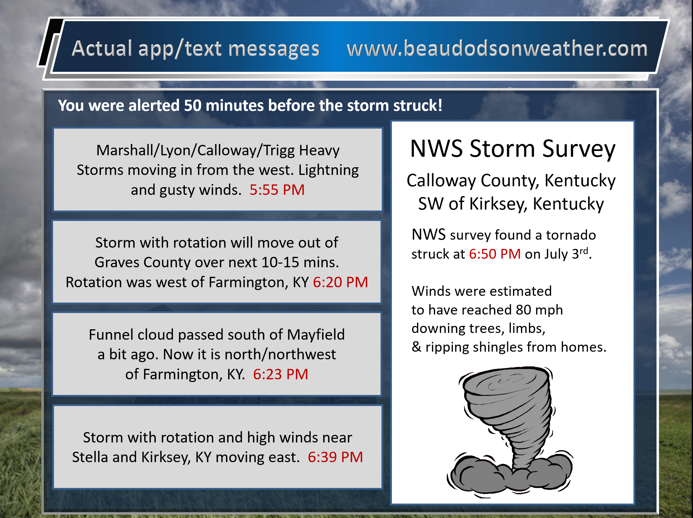
WeatherOne messages will look like this
This is a real example of actual messages sent out during an event
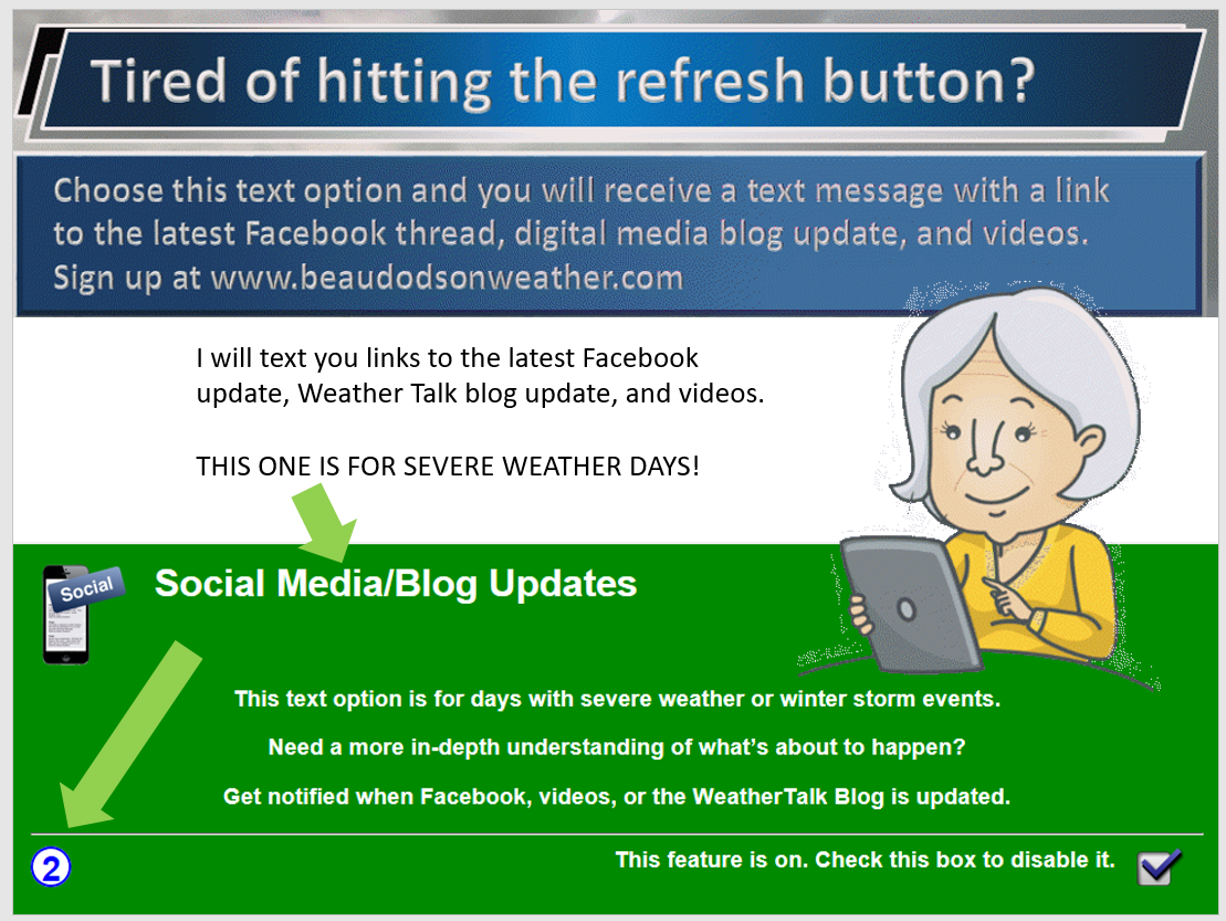
Don’t forget you can also turn on the severe weather day social media updates. I will send you the latest Facebook update, blog update, and more.
The main weather concern today remains the risk of severe thunderstorms.
Everything appears to point towards the potential of a few thunderstorms this morning in the region. For the most part, those would likely remain below severe levels. I can’t rule out a severe thunderstorm warning.
Eyes then turn towards this afternoon into tonight.
A potent storm system will push into the Ohio Valley. This system will set the stage for an unstable atmosphere as we move through this afternoon.
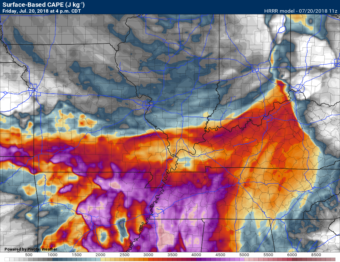
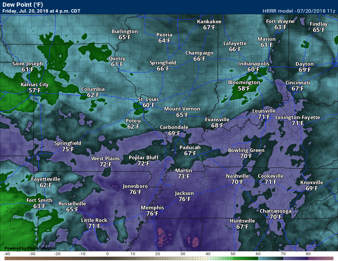
CAPE values are anticipated to exceed 3500. That is high. CAPE is potential energy for storms to tap into. CAPE tends to be high during the Month of July. This is mainly because of the heat and high dew points.
Of more concern is the potential of wind shear.
Typically, during July and August, our upper level winds are light. Not a lot of jet stream energy. Today, however, will be an exception to the rule.
Wind shear (the turning or increase of wind speed with height) is forecast to be more like late spring. This will help produce severe thunderstorms.
Wind shear can help thunderstorms to remain severe for longer periods of time.
As always, there remain questions about how this event unfolds.
It appears that the greatest risk of severe weather will extend from the Missouri Bootheel into the extreme southern seven counties of southern Illinois, and then into Kentucky and Tennessee.
It is this area that the atmosphere should become the most unstable.
Storms could produce hail large than half dollars in some areas. There is also the potential of wind gusts above 65 mph. I can’t rule out tornadoes.
This is the kind of day where we hope for the best but be prepared in case severe storms form.
Storms will be moving from the west and northwest towards the south and southeast. Storms should move at 30 to 45 mph.
Monitor updates today.
Here is the Hrrr model future-cast radar.
Time stamp is located in the upper left portion of the graphic.
This is one models opinion.
Notice how portions of the region remain free of thunderstorms. That is quite possible today. Some areas will have severe weather, but not all.
Click to enlarge graphics
CAPE values. CAPE is a measure of energy
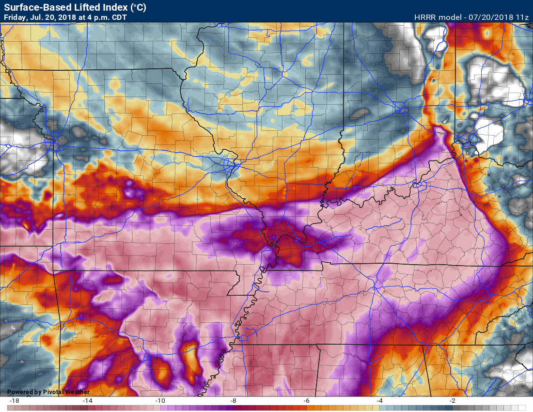
Lift index values. This gives us some idea on the buoyancy of the atmosphere. You need that to lift air parcels upward. That helps create thunderstorms.


The Storm Prediction Center has placed our region in a level 2, 3, and 4 risk zone. Five is the highest.
The orange and red zone stand the greatest risk today of severe storms. I would not let me guard down elsewhere, as well.
![]()
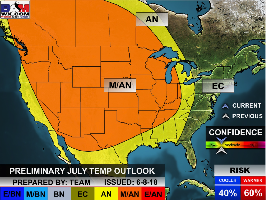
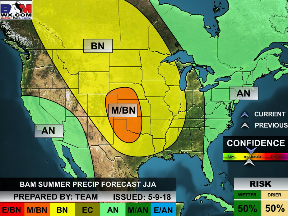
The July forecast has been updated. The heat will likely be the big story.
Outlook definitions
EQ = Equal chances of above or below normal
BN= Below normal
M/BN = Much below normal
AN = Above normal
M/AN = Much above normal
E/AN = Extremely above normal.
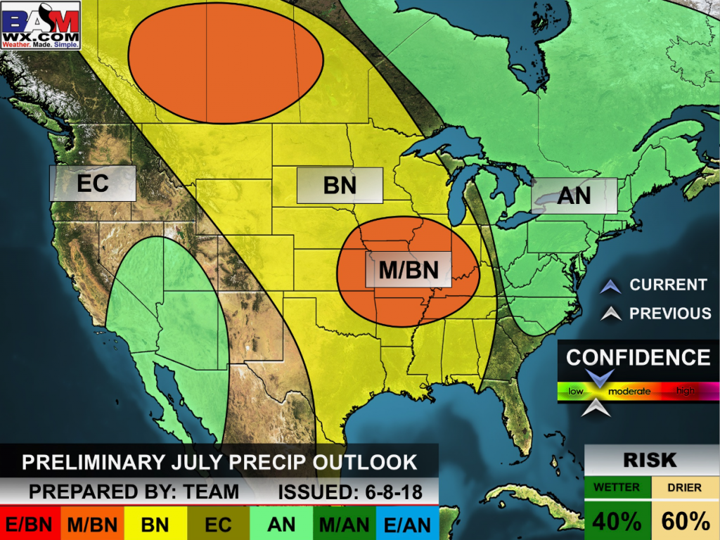
Outlook definitions
EQ = Equal chances of above or below normal
BN= Below normal
M/BN = Much below normal
AN = Above normal
M/AN = Much above normal
E/AN = Extremely above normal.
![]()
These are bonus videos and maps for subscribers.
I bring these to you from the BAMwx team. I pay them to help with videos. They have a great team of meteorologists. The Ohio and Missouri Valley videos cover most of our area. They do not have a specific Tennessee Valley forecast but may add one in the future.
The long-range video is technical. Over time, you can learn a lot about meteorology from the long range video. Just keep in mind, it is a bit more technical.
NOTE: THESE ARE USUALLY NOT UPDATED ON SATURDAY OR SUNDAY.

These videos are a bonus for subscribers.
This one is centered on the Ohio Valley.
Keep in mind that this covers a larger region than just our local counties.
Illinois/Ohio Valley

Long Range Video (more technical discussion)

Missouri Valley and Central Plains

I bring these to you from the BAMwx team. They are excellent long-range forecasters.
Remember, long-range outlooks are a bit of skill, understanding weather patterns, and luck combined. It is not an exact science.

Outlook definitions
EQ = Equal chances of above or below normal
BN= Below normal
M/BN = Much below normal
AN = Above normal
M/AN = Much above normal
E/AN = Extremely above normal.
Normal high temperatures for this time of the year are around 92 degrees.
Normal low temperatures for this time of the year are around 69 degrees.
Normal precipitation during this time period ranges from 0.25″ to 0.50″
This outlook covers July 20th through July 26th
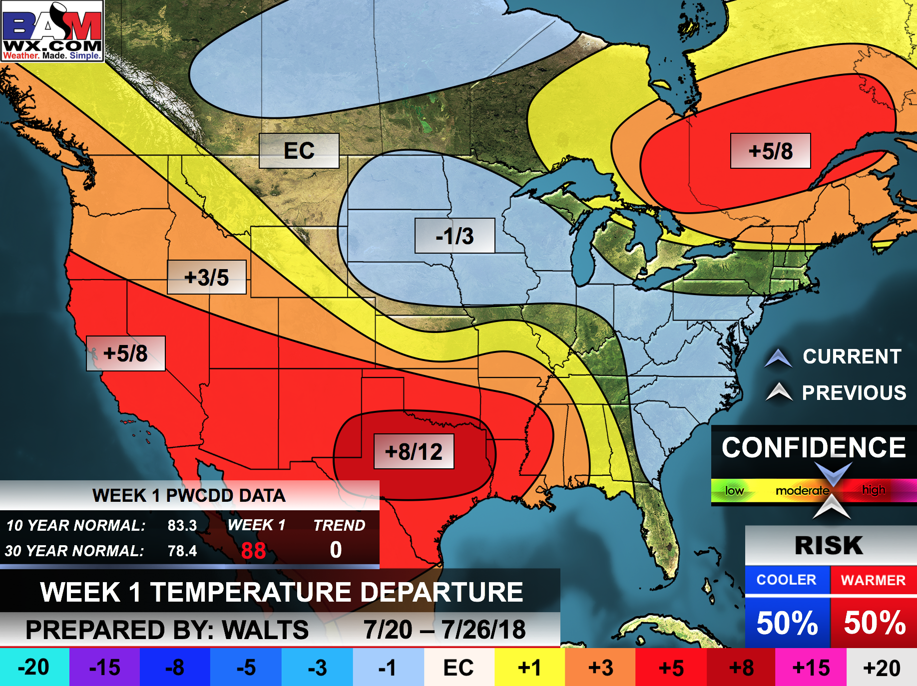
The precipitation forecast is PERCENT OF NORMAL. For example, if your normal rainfall is 1.00″ and the graphic shows 10%, then that would mean 0.10″ of rain is anticipated.
Always keep in mind, slow moving summer thunderstorms can produce torrential rain. That could skew the rainfall outlook.


Outlook definitions
EQ = Equal chances of above or below normal
BN= Below normal
M/BN = Much below normal
AN = Above normal
M/AN = Much above normal
E/AN = Extremely above normal.
Normal high temperatures for this time of the year are around 92 degrees
Normal low temperatures for this time of the year are around 69 degrees
Normal precipitation during this time period ranges from 0.25″ to 0.50″
This outlook covers July 26th through August 1st
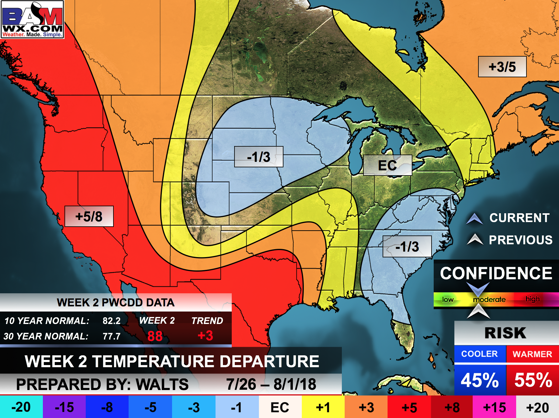
The precipitation forecast is PERCENT OF NORMAL. For example, if your normal rainfall is 1.00″ and the graphic shows 10%, then that would mean 0.10″ of rain is anticipated.
Always keep in mind, slow moving summer thunderstorms can produce torrential rain. That could skew the rainfall outlook.


Outlook definitions
EQ = Equal chances of above or below normal
BN= Below normal
M/BN = Much below normal
AN = Above normal
M/AN = Much above normal
E/AN = Extremely above normal.
Normal high temperatures for this time of the year are around 92 degrees
Normal low temperatures for this time of the year are around 70 degrees
Normal precipitation during this time period ranges from 0.25″ to 0.50″
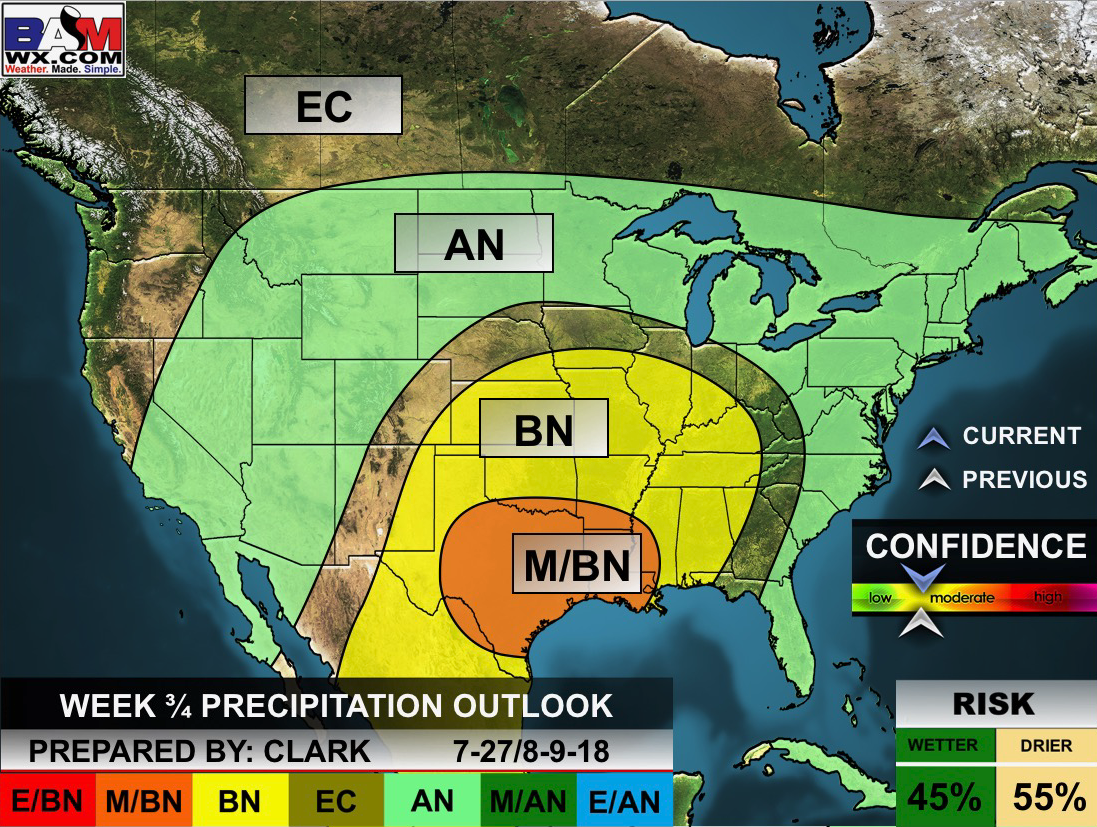
This outlook covers July 27th through August 9th
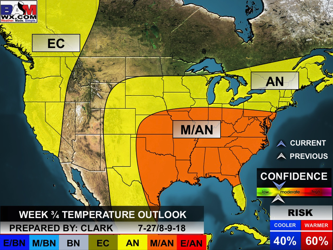
And precipitation
Always keep in mind, slow moving summer thunderstorms can produce torrential rain. That could skew the rainfall outlook.
Outlook definitions
EQ = Equal chances of above or below normal
BN= Below normal
M/BN = Much below normal
AN = Above normal
M/AN = Much above normal
E/AN = Extremely above normal.
Temperature outlook for June through August.
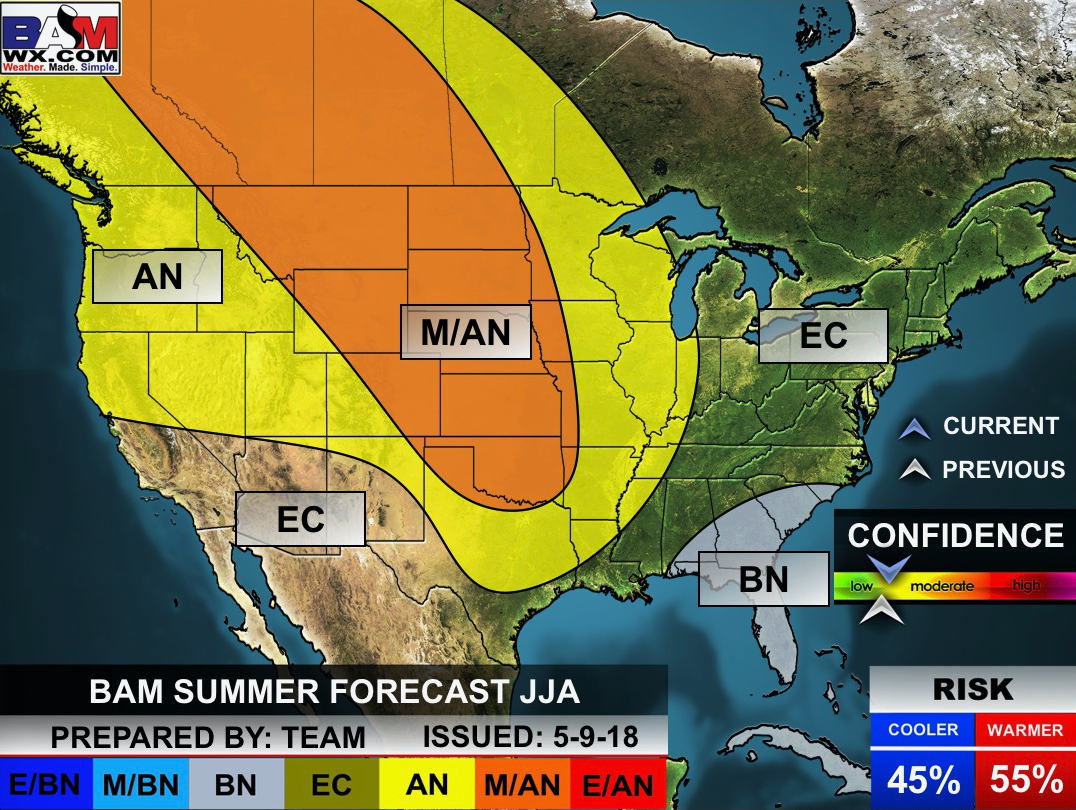
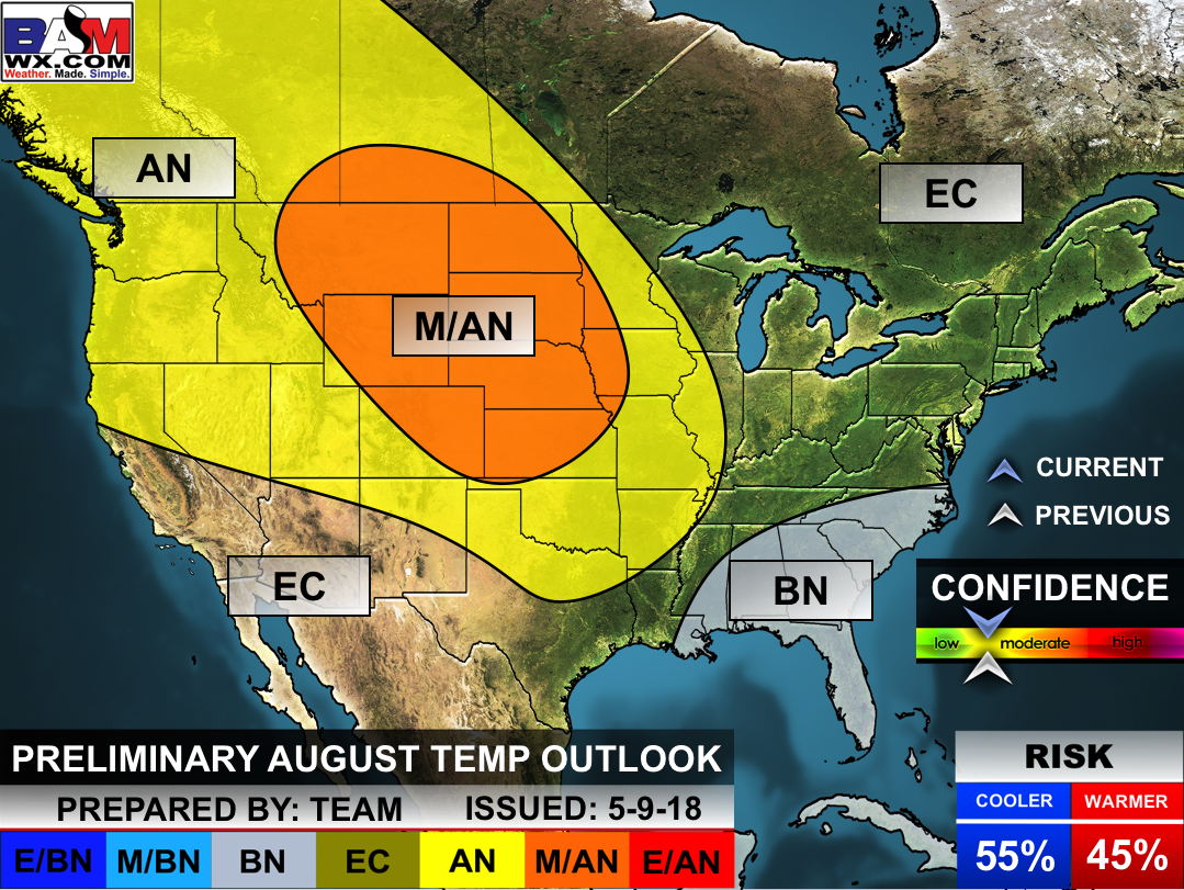
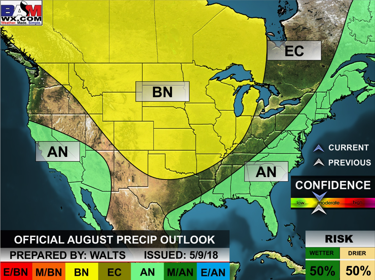
August temperature and precipitation outlook
Outlook definitions
EQ = Equal chances of above or below normal
BN= Below normal
M/BN = Much below normal
AN = Above normal
M/AN = Much above normal
E/AN = Extremely above normal.
![]()

A new weather podcast is now available! Weather Geeks (which you might remember is on The Weather Channel each Sunday)
To learn more visit their website. Click here.
![]()

WeatherBrains Episode 652
Tonight’s Guest WeatherBrain is a meteorologist at the Naval Research Laboratory. Dr. David Peterson, welcome to WeatherBrains!
Last year was a record year for wildfires across the globe, and their impact on the atmosphere remains highly uncertain. Thanks to new research from expert scientists at the U.S. Naval Research Laboratory, the world is gaining more insight into what drives these massive and escalating events. NRL meteorologist Dr. Peterson explained his findings from his recent research, “Wildfire-Driven Thunderstorms Cause a Volcano-Like Stratospheric Injection of Smoke,” during a press conference at the European Geosciences Union’s annual General Assembly in Vienna, Austria, held from April 8 to 13. “Our research shows that the stratospheric impact from five wildfire-driven thunderstorms, known as pyrocumulonimbus or pyroCb, was comparable to a moderate volcanic eruption,” Peterson explained the NRL pryoCb research team’s findings and that it’s an interdisciplinary collaboration with scientists from both the Marine Meteorology and Remote Sensing Divisions within NRL. The significance of volcanic eruptions in the climate system has been recognized for several decades, but pyroCb research is relatively new, originating at NRL in the early 2000s, according to Peterson.
Other discussions in this weekly podcast include topics like:
- Extremes: 120 at Death Valley, CA, and 41 at Naples, ID
- NASA Sponsored Joint Korea/US Air Quality Campaign
- Birmingham reached 105F on this date in 1980
- Tropics all quiet in Atlantic basin
- Astronomy Outlook with Tony Rice
- and more!
Link https://weatherbrains.com/
Previous episodes can be viewed by clicking here.
We offer interactive local city live radars and regional radars. If a radar does not update then try another one. If a radar does not appear to be refreshing then hit Ctrl F5. You may also try restarting your browser.
The local city view radars also have clickable warnings.
During the winter months, you can track snow and ice by clicking the winterize button on the local city view interactive radars.
You may email me at beaudodson@usawx.com
Find me on Facebook!

Find me on Twitter!

Did you know that a portion of your monthly subscription helps support local charity projects?
You can learn more about those projects by visiting the Shadow Angel Foundation website and the Beau Dodson News website.

I encourage subscribers to use the app vs regular text messaging. We have found text messaging to be delayed during severe weather. The app typically will receive the messages instantly. I recommend people have three to four methods of receiving their severe weather information.
Remember, my app and text alerts are hand typed and not computer generated. You are being given personal attention during significant weather events.
