For $3 a month you can receive the following. You may choose to receive these via your WeatherTalk app or regular text messaging.
- Severe weather app/text alerts from my keyboard to your app/cell phone. These are hand typed by Beau. During tornado outbreaks, you will receive numerous app/text messages telling you exactly where the tornado is located.
- Daily forecast app/texts from my computer to your app/cell phone.
- Social media links sent directly to your app/cell phone. When I update the blog, videos, or Facebook you will receive the link.
- AWARE emails. These emails keep you well ahead of the storm. They give you several days of lead time before significant weather events.
- Direct access to Beau via text and email. Your very own personal meteorologist. I work for you!
- Missouri and Ohio Valley centered video updates
- Long-range weather videos
- Week one, two, three and four temperature and precipitation outlooks.
- Monthly outlooks.
- Your subscription also will help support several local charities.
Haven’t you subscribed? Subscribe at www.beaudodsonweather.com

I encourage subscribers to use the app vs regular text messaging. We have found text messaging to be delayed during severe weather. The app typically will receive the messages instantly. I recommend people have three to four methods of receiving their severe weather information.
Remember, my app and text alerts are hand typed and not computer generated. You are being given my personal attention during significant weather events.

WWW.WEATHERTALK.COM subscribers, here is my day to day schedule for your weather products.


July 19, 2018
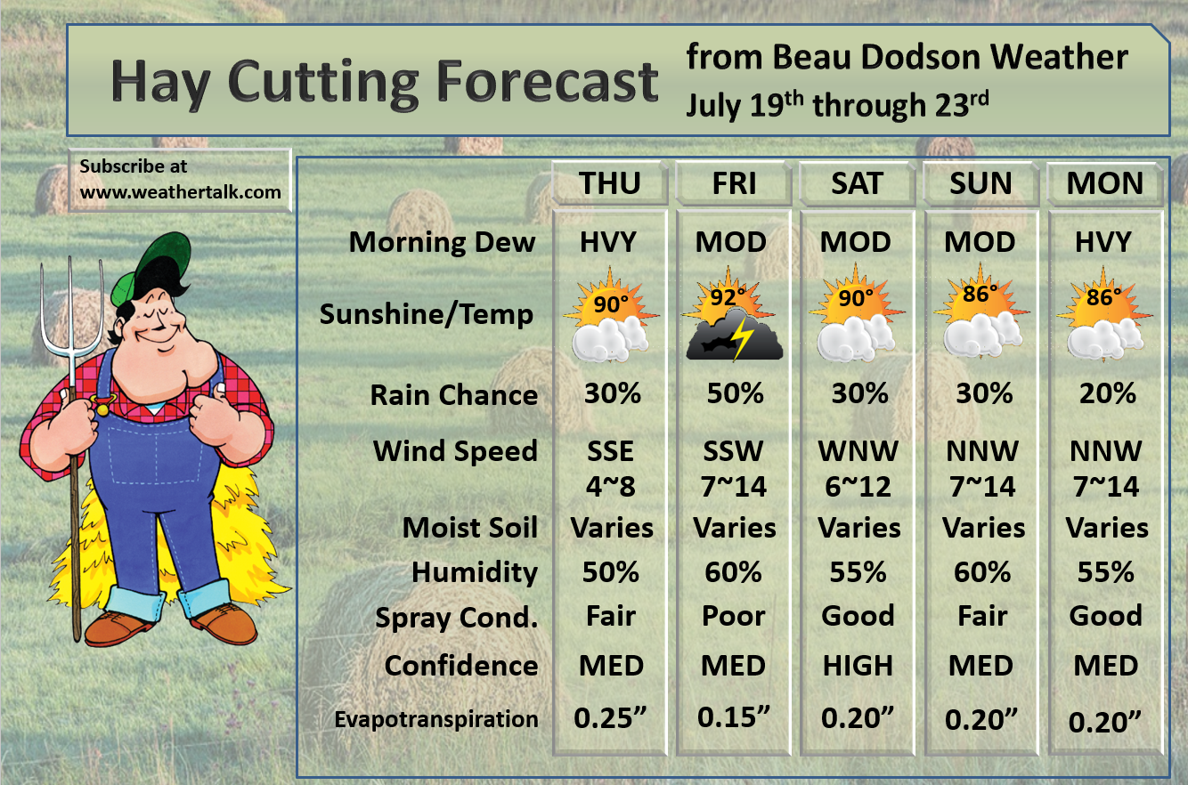
Thursday Forecast Details
Forecast: Partly cloudy. A few thunderstorms possible. Some storms could be intense. Lower confidence on rain coverage Thursday. Some of the guidance pops a line of storms in the region.
Temperatures: MO ~ 85 to 90 IL ~ 85 to 90 KY ~ 85 to 90 TN ~ 85 to 90
What is the chance of precipitation? MO ~ 40% IL ~ 30% KY ~ 30% TN ~ 30%
Coverage of precipitation: Scattered, but monitor updates
Wind: South and southeast at 5 to 10 mph
What impacts are anticipated from the weather? Wet roadways. Lightning. Occasionally, summer storms can produce pockets of damaging wind.
My confidence in the forecast verifying: Medium
Is severe weather expected? If storms form they could produce spotty high wind and hail reports
The NWS defines severe weather as 58 mph wind or great, 1″ hail or larger, and/or tornadoes
Should I cancel my outdoor plans? No, but check radars
UV Index: 8 to 10 High
Sunrise: 5:49 AM
Thursday Night Forecast Details:
Forecast: Partly cloudy. Scattered thunderstorms possible. A few intense storms again possible.
Temperatures: MO ~ 68 to 74 IL ~ 68 to 74 KY ~ 68 to 74 TN ~ 68 to 74
What is the chance of precipitation? MO ~ 40% IL ~ 30% KY ~ 30% TN ~ 30%
Coverage of precipitation: Scattered
Wind: Southeast at 5 to 10 mph with gusts to 12
What impacts are anticipated from the weather? Wet roadways and lightning. Hail possible. Torrential downpours.
My confidence in the forecast verifying: Medium
Is severe weather expected? A few reports of hail will be possible. Gusty wind near storms.
The NWS defines severe weather as 58 mph wind or great, 1″ hail or larger, and/or tornadoes
Should I cancel my outdoor plans? No, but check radars
Sunset: 8:12 PM
Moonrise: 1:05 PM Waxing Crescent
Moonset: 12:16 AM
July 20, 2018
Friday Forecast Details
Forecast: Partly cloudy. Hot and muggy. A chance of thunderstorms. We may have line of thunderstorms during the morning hours across southern Illinois and western Kentucky. Lesser chances further south and west. A few storms could be intense. Some question on storm coverage. Guidance shows everything from no storms to widespread storms. Best advice is to monitor updates.
Temperatures: Highs will be highly dependent on morning clouds and precipitation. More clouds would lower the high temperatures. MO ~ 94 to 98 IL ~ 88 to 94 KY ~ 88 to 94 TN ~ 88 to 94
What is the chance of precipitation? MO ~ 30% to 40% IL ~ 40% to 50% KY ~ 60% TN ~ 40% to 50%
Coverage of precipitation: Scattered to perhaps numerous
Wind: Southwest at 5 to 10 mph with gusts to 20 mph
What impacts are anticipated from the weather? Wet roadways and lightning. A few strong/severe storms possible. Hail. Pockets of wind damage. There is some risk of tornadoes if storms form. Heavy downpours.
My confidence in the forecast verifying: LOW
Is severe weather expected? There is some risk of severe weather.
The NWS defines severe weather as 58 mph wind or great, 1″ hail or larger, and/or tornadoes
Should I cancel my outdoor plans? Monitor radars and updates. Storms are possible.
UV Index: 8 to 9 High
Sunrise: 5:50 AM
Friday Night Forecast Details:
Forecast: Partly cloudy. A chance of thunderstorm. Some storms could be intense.
Temperatures: MO ~ 66 to 72 IL ~ 66 to 72 KY ~ 66 to 72 TN ~ 66 to 72
What is the chance of precipitation? MO ~ 30% IL ~ 30% to 40% KY ~ 60% TN ~ 40% to 50%
Coverage of precipitation: Scattered to perhaps numerous. Low confidence on coverage.
Wind: West and northwest at 5 to 10 mph
What impacts are anticipated from the weather? Wet roadways and lightning. Heavy rain where storms occur. Some strong or severe storms possible.
My confidence in the forecast verifying: LOW
Is severe weather expected? Severe storms are possible in the region (mainly during the evening hours)
The NWS defines severe weather as 58 mph wind or great, 1″ hail or larger, and/or tornadoes
Should I cancel my outdoor plans? Monitor updates and radars.
Sunset: 8:12 PM
Moonrise: 2:06 PM First quarter
Moonset: 12:48 AM
July 21, 2018
Saturday Forecast Details
Forecast: Mostly sunny. A few clouds. Most of the thunderstorms should have ended. Warm.
Temperatures: MO ~ 86 to 90 IL ~ 86 to 90 KY ~ 86 to 92 TN ~ 86 to 92
What is the chance of precipitation? MO ~ 10% IL ~ 10% to 20% KY ~ 20% TN ~ 20%
Coverage of precipitation: I can’t rule out some storms over mainly southeast Illinois and the Pennyrile area of western Kentucky
Wind: Northwest at 5 to 10 mph with gusts to 14 mph
What impacts are anticipated from the weather? Isolated.
My confidence in the forecast verifying: Medium
Is severe weather expected? No
The NWS defines severe weather as 58 mph wind or great, 1″ hail or larger, and/or tornadoes
Should I cancel my outdoor plans? No
UV Index: 9 to 10 High
Sunrise: 5:50 AM
Saturday Night Forecast Details:
Forecast: Mostly clear. Mild. A few clouds over southeast Illinois and western Kentucky. Isolated storms possible across southeast Illinois and mainly the Pennyrile area of western Kentucky.
Temperatures: MO ~ 65 to 70 IL ~ 65 to 70 KY ~ 65 to 70 TN ~ 65 to 70
What is the chance of precipitation? MO ~ 5% IL ~ 20% KY ~ 20% TN ~ 5%
Coverage of precipitation: None to isolated
Wind: North and northwest at 5 to 10 mph with gusts to 15 mph
What impacts are anticipated from the weather? None to perhaps wet roadways and lightning.
My confidence in the forecast verifying: Medium
Is severe weather expected? No
The NWS defines severe weather as 58 mph wind or great, 1″ hail or larger, and/or tornadoes
Should I cancel my outdoor plans? No
Sunset: 8:13 PM
Moonrise: 3:06 PM Waxing Gibbous
Moonset: 1:21 AM
July 22, 2018
Sunday Forecast Details
Forecast: Mostly sunny over southeast Missouri with a mix of sun and clouds elsewhere. Warm. Widely scattered thunderstorms.
Temperatures: MO ~ 86 to 90 IL ~ 82 to 86 KY ~ 84 to 88 TN ~ 85 to 90
What is the chance of precipitation? MO ~ 20% IL ~ 30% KY ~ 30% to 40% TN ~ 20%
Coverage of precipitation: Widely scattered
Wind: Northwest at 7 to 14 mph with gusts to 20 mph
What impacts are anticipated from the weather? Wet roadways. Lightning.
My confidence in the forecast verifying: Medium
Is severe weather expected? Unlikely
The NWS defines severe weather as 58 mph wind or great, 1″ hail or larger, and/or tornadoes
Should I cancel my outdoor plans? No, but check radars. Some storms are possible
UV Index: 7 to 10 High (highest over southeast Missouri and lower over southeast Illinois and eastern parts of west Kentucky
Sunrise: 5:51 AM
Sunday Night Forecast Details:
Forecast: Perhaps a few clouds. Otherwise, mostly clear. Mild. Isolated thunderstorms possible early.
Temperatures: MO ~ 66 to 70 IL ~ 64 to 68 KY ~ 64 to 68 TN ~ 65 to 70
What is the chance of precipitation? MO ~ 10% IL ~ 20% KY ~ 20% TN ~ 10%
Coverage of precipitation: Most likely none. A slight chance of an evening isolated thunderstorm.
Wind: North at 3 to 6 mph with gusts to 14 mph
What impacts are anticipated from the weather? Most likely none. Isolated wet roadways and lightning (mainly early)
My confidence in the forecast verifying: Medium
Is severe weather expected? No
The NWS defines severe weather as 58 mph wind or great, 1″ hail or larger, and/or tornadoes
Should I cancel my outdoor plans? No, but perhaps check the radars during the evening hours
Sunset: 8:10 PM
Moonrise: 4:03 PM Waxing Gibbous
Moonset: 1:56 AM
July 23, 2018
Monday Forecast Details
Forecast: Partly to mostly sunny. A chance of widely scattered thunderstorms (mainly during the afternoon hours)
Temperatures: MO ~ 85 to 90 IL ~ 83 to 86 KY ~ 85 to 88 TN ~ 86 to 88
What is the chance of precipitation? MO ~ 10% IL ~ 20% KY ~ 20% TN ~ 10%
Coverage of precipitation: Isolated to widely scattered
Wind: North and northeast at 7 to 14 mph
What impacts are anticipated from the weather? A few wet roadways and lightning.
My confidence in the forecast verifying: Medium
Is severe weather expected? No
The NWS defines severe weather as 58 mph wind or great, 1″ hail or larger, and/or tornadoes
Should I cancel my outdoor plans? No, but check radars
UV Index: 9 to 10 High
Sunrise: 5:52 AM
Monday Night Forecast Details:
Forecast: Mostly clear with a few clouds. An isolated evening storm possible.
Temperatures: MO ~ 66 to 72 IL ~ 64 to 68 KY ~ 65 to 68 TN ~ 65 to 68
What is the chance of precipitation? MO ~ 10% IL ~ 20% KY ~ 20% TN ~ 20%
Coverage of precipitation: None to isolated
Wind: North at 3 to 6 mph
What impacts are anticipated from the weather? Isolated wet roadways and lightning.
My confidence in the forecast verifying: Medium
Is severe weather expected? No
The NWS defines severe weather as 58 mph wind or great, 1″ hail or larger, and/or tornadoes
Should I cancel my outdoor plans? No, but check radars
Sunset: 8:10 PM
Moonrise: 4:59 PM Waxing Gibbous
Moonset: 2:33 AM
July 24, 2018
Tuesday Forecast Details
Forecast: Partly sunny. Warm. Isolated to widely scattered thunderstorms.
Temperatures: MO ~ 85 to 90 IL ~ 83 to 86 KY ~ 85 to 88 TN ~ 86 to 88
What is the chance of precipitation? MO ~ 20% IL ~ 20% KY ~ 20% TN ~ 20%
Coverage of precipitation: Isolated to widely scattered
Wind: North and northeast at 6 to 12 mph
What impacts are anticipated from the weather? Wet roadways. Lightning.
My confidence in the forecast verifying: Medium
Is severe weather expected? Not at this time
The NWS defines severe weather as 58 mph wind or great, 1″ hail or larger, and/or tornadoes
Should I cancel my outdoor plans? No, but check radars
UV Index: 9 to 10 High
Sunrise: 5:53 AM
Tuesday Night Forecast Details:
Forecast: Partly cloudy. An isolated evening thunderstorm possible.
Temperatures: MO ~ 66 to 72 IL ~ 64 to 68 KY ~ 65 to 68 TN ~ 65 to 68
What is the chance of precipitation? MO ~ 10% IL ~ 10% KY ~ 10% TN ~ 10%
Coverage of precipitation: None to isolated
Wind: Northeast at 5 to 10 mph
What impacts are anticipated from the weather? None to perhaps a few wet roadways and lightning
My confidence in the forecast verifying: Medium
Is severe weather expected? Not at this time
The NWS defines severe weather as 58 mph wind or great, 1″ hail or larger, and/or tornadoes
Should I cancel my outdoor plans? No
Sunset: 8:09 PM
Moonrise: 5:52 PM Waxing Gibbous
Moonset: 3:14 AM
July 25, 2018
Wednesday Forecast Details
Forecast: Mostly sunny to partly cloudy. Widely scattered thunderstorms possible.
Temperatures: MO ~ 85 to 90 IL ~ 85 to 90 KY ~ 85 to 90 TN ~ 85 to 90
What is the chance of precipitation? MO ~ 20% IL ~ 20% KY ~ 30% TN ~ 30%
Coverage of precipitation: Widely scattered
Wind: North and northeast at 5 to 10 mph
What impacts are anticipated from the weather? Wet roadways. Lightning.
My confidence in the forecast verifying: LOW
Is severe weather expected? No
The NWS defines severe weather as 58 mph wind or great, 1″ hail or larger, and/or tornadoes
Should I cancel my outdoor plans? No
UV Index: 9 to 10 High
Sunrise: 5:54 AM
Wednesday Night Forecast Details:
Forecast: Partly cloudy. Widely scattered thunderstorms again possible.
Temperatures: MO ~ 66 to 72 IL ~ 66 to 70 KY ~ 66 to 70 TN ~ 66 to 70
What is the chance of precipitation? MO ~ 20% IL ~ 20% KY ~ 20% TN ~ 20%
Coverage of precipitation: Widely scattered
Wind: Northeast at 5 to 10 mph
What impacts are anticipated from the weather? Wet roadways and lightning.
My confidence in the forecast verifying: LOW
Is severe weather expected? No
The NWS defines severe weather as 58 mph wind or great, 1″ hail or larger, and/or tornadoes
Should I cancel my outdoor plans? No, but check radars
Sunset: 8:08 PM
Moonrise: 6:42 PM Waxing Gibbous
Moonset: 3:59 AM
July 26, 2018
Thursday Forecast Details
Forecast: Mostly sunny.
Temperatures: MO ~ 84 to 88 IL ~ 84 to 88 KY ~ 84 to 88 TN ~ 84 to 88
What is the chance of precipitation? MO ~ 0% IL ~ 0% KY ~ 0% TN ~ 0%
Coverage of precipitation: Most likely none
Wind:
What impacts are anticipated from the weather? Most likely none
My confidence in the forecast verifying: LOW
Is severe weather expected? No
The NWS defines severe weather as 58 mph wind or great, 1″ hail or larger, and/or tornadoes
Should I cancel my outdoor plans? No
UV Index: 9 to 10 High
Sunrise: 5:54 AM
Thursday Night Forecast Details:
Forecast: Mostly clear.
Temperatures: MO ~ 63 to 66 IL ~ 63 to 66 KY ~ 63 to 66 TN ~ 63 to 66
What is the chance of precipitation? MO ~ 0% IL ~ 0% KY ~ 0% TN ~ 0%
Coverage of precipitation: Most likely none
Wind:
What impacts are anticipated from the weather? Most likely none
My confidence in the forecast verifying: LOW
Is severe weather expected? No
The NWS defines severe weather as 58 mph wind or great, 1″ hail or larger, and/or tornadoes
Should I cancel my outdoor plans? No
Sunset: 8:07 PM
Moonrise: 7:28 PM Waxing Gibbous
Moonset: 4:47 AM
July 27, 2018
Friday Forecast Details
Forecast: Mostly sunny.
Temperatures: MO ~ 84 to 88 IL ~ 84 to 88 KY ~ 84 to 88 TN ~ 84 to 88
What is the chance of precipitation? MO ~ 0% IL ~ 0% KY ~ 0% TN ~ 0%
Coverage of precipitation: Most likely none
Wind:
What impacts are anticipated from the weather? Most likely none
My confidence in the forecast verifying: LOW
Is severe weather expected? No
The NWS defines severe weather as 58 mph wind or great, 1″ hail or larger, and/or tornadoes
Should I cancel my outdoor plans? No
UV Index: 9 to 10 High
Sunrise: 5:55 AM
Friday Night Forecast Details:
Forecast: Mostly clear.
Temperatures: MO ~ 63 to 66 IL ~ 63 to 66 KY ~ 63 to 66 TN ~ 63 to 66
What is the chance of precipitation? MO ~ 0% IL ~ 0% KY ~ 0% TN ~ 0%
Coverage of precipitation: Most likely none
Wind:
What impacts are anticipated from the weather? Most likely none
My confidence in the forecast verifying: LOW
Is severe weather expected? No
The NWS defines severe weather as 58 mph wind or great, 1″ hail or larger, and/or tornadoes
Should I cancel my outdoor plans? No
Sunset: 8:06 PM
Moonrise: 8:10 PM Waxing Gibbous
Moonset: 5:39 AM
Learn more about the UV index readings. Click here.

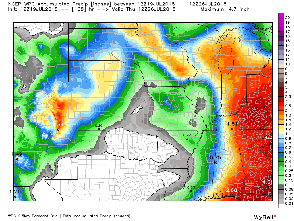
Here is the latest WPC / NOAA Rainfall charts
This graphic will not cover those wild swings in rainfall totals that occur from locally heavy thunderstorms. These number will be greatly underdone where slow moving thunderstorms occur.
This is the seven-day rainfall map (below)
Here are the rain totals through Thursday morning
** Again, thunderstorms can produce much higher totals. Keep that in mind **
.

We offer interactive local city live radars and regional radars. If a radar does not update then try another one.
If a radar does not appear to be refreshing then hit Ctrl F5 on your keyboard.
You may also try restarting your browser.
The local city view radars also have clickable warnings.
During the winter months, you can track snow and ice by clicking the winterize button on the local city view interactive radars.

Questions? Broken links? Other questions?
You may email me at beaudodson@usawx.com

The National Weather Service defines a severe thunderstorm as one that produces quarter size hail or larger, 58 mph winds or greater, and/or a tornado.
Thursday into Friday evening:
Bottom line: Monitor updates as we move into Friday.
Thunderstorms will be possible Thursday and Thursday night. Storms will produce heavy downpours, gusty winds, frequent lightning, and possibly a few reports of hail. A few severe thunderstorms are possible.
Severe thunderstorms are possible Friday into Friday night. Perhaps the peak of the risk will be Friday afternoon and evening.
THERE REMAIN QUESTIONS ABOVE THIS EVENT. GUIDANCE RANGES FROM NO STORMS TO WIDESPREAD STORMS.
Large hail, damaging wind, frequent lightning, and downpours will likely occur where storms form. We will need to monitor the tornado risk, as well (IF storms form).
Supercell thunderstorms are possible. Those type of storms are more widely scattered and can tap into the CAPE (energy).
A squall line is possible somewhere in the region. A line of thunderstorms. This line of storms, if it forms, would produce damaging winds.
I recommend you stay informed on the latest weather information. Questions remain about the actual extent of the severe weather risk.
This morning’s guidance has not helped raise the confidence.
There remain some questions about morning clouds cover and storms keeping instability down. If that occurs then the risk of severe weather decreases later in the day. This is still an unknown.
There will be an abnormal amount of wind shear (for July) Friday. Wind shear is the turning of wind with height and/or the increase of wind speed with height. This is one ingredient when forecasting severe thunderstorms.
Saturday through Wednesday: For the time being it appears that severe thunderstorm chances will be low. There will be at least a daily chance of widely scattered thunderstorms in the region. Lightning would be the primary concern.
Summer thunderstorms can produce isolated microbursts.
microburst winds can exceed 50 mph.
What are microbursts?

Interactive live weather radar page. Choose the city nearest your location. If one of the cities does not work then try a nearby one. Click here.
National map of weather watches and warnings. Click here.
Storm Prediction Center. Click here.
Weather Prediction Center. Click here.

Live lightning data: Click here.

Interactive GOES R satellite. Track clouds. Click here.

Here are the latest local river stage forecast numbers Click Here.
Here are the latest lake stage forecast numbers for Kentucky Lake and Lake Barkley Click Here.

The summer outlook have been posted for subscribers. Scroll down to see the outlook.Not a subscriber? Learn more at this link.

Weather Headlines
- A few storms today and tonight
- Monitoring the potential of severe thunderstorms late Thursday night into Friday night
- Saturday into Sunday should be dry
- Somewhat cooler next week
- Monitor thunderstorm chances Thursday.
This discussion will center on the severe weather risk Friday.
We have a rather unusual situation developing. A lot of questions remain and confidence isn’t all that great in the eventual outcome.
Here are my latest thoughts.
We don’t typically see the severe weather parameter numbers that guidance/model packages are spitting out during the Month of July.
Wind fields aloft are normally weak during July and August. That usually keeps the risk of severe weather rather low.
We are seeing spring like numbers showing up in the charts Friday into Friday night. IF thunderstorms do form Friday then they could be quite intense.
Let’s break it down.
Thursday into Thursday night
A few thunderstorms are possible today and tonight. Widely scattered. Many areas may remain dry.
I am monitoring to see if a line of storms forms in Missouri later today and then dives south and southeast. If that happens then rain chances would increase a bit. For now, the numbers above (in the daily outlook) seem right.
Thunderstorms that form today and tonight could produce some heavy downpours, gusty winds, lightning, and even hail. There is a low end risk of severe thunderstorms between now and Friday morning. Hail is the main concern. Damaging wind is the second concern. Lightning, of course.
Friday and Friday night
A cold front, accompanied by an area of low pressure, will move southeast into the Ohio Valley on Friday. This system will help initiate strong wind fields aloft. These strong wind fields will be a key ingredient in the potential of severe thunderstorms.
CAPE values, a measure of energy in the atmosphere, will top 3000 Friday afternoon.
CAPE is an important ingredient in the development of severe thunderstorms. Think of CAPE as energy for thunderstorms to devour. The higher the CAPE numbers the greater the risk a thunderstorm will become severe (with other ingredients, as well).
High CAPE numbers alone do not mean severe weather. You must have lift, moisture, and wind shear.
Dew points will be in the middle 60’s to lower 70’s. That is a lot of moisture for thunderstorms to work with. PWAT values (a measure of moisture in the entire atmosphere) will likely top 1.5″. Some of the guidance shows 1.8″+ PWAT values. Either way, there will be no shortage of moisture. This means torrential downpours where/if thunderstorms occur/develop.
Wind fields will strengthen and shear values will top 40 mph. There will also be spin in the atmosphere. Wind direction will change with height. This increases the risk of severe thunderstorms.
Think of wind shear as turning of wind direction as you climb a latter into the atmosphere. Another type of wind shear is speed shear. That means the wind increases as you climb upward into the atmosphere.
Directional and speed shear helps keep thunderstorms fueled.
Now, there are questions that remain about Friday.
Some of the guidance shows almost no thunderstorm activity. Some guidance packages are showing isolated thunderstorms (supercells). Other guidance shows widespread thunderstorms.
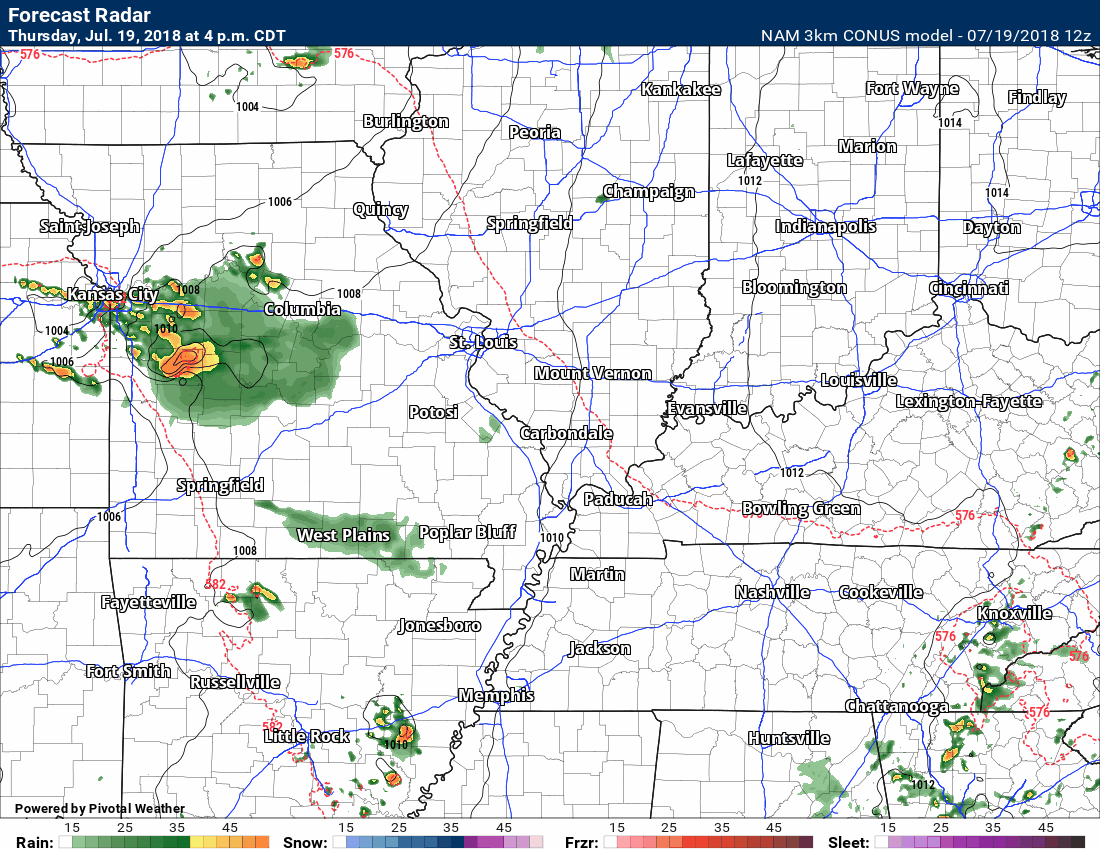
Here is the morning 3K NAM (high resolution model). I am waiting on more data to see if there is any agreement on this.
The NAM shows a morning line of severe thunderstorms and then dry the rest of the day (perhaps a few showers or storms).
Time-stamp upper left
Here is another high resolution model. This is the SPC WRF. This model typically does well with severe weather events.
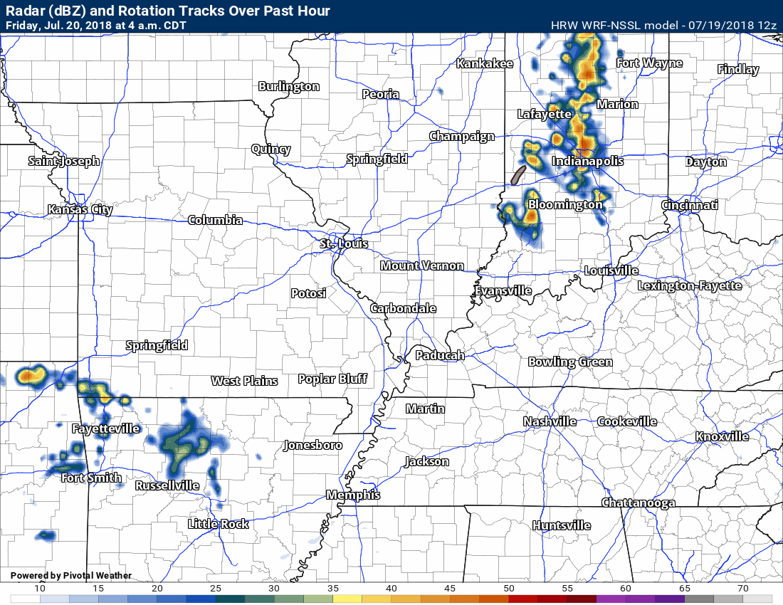
If supercell thunderstorms form then they could produce golf-ball size hail or larger, 70+ MPH winds, and even tornadoes.
There remain some questions, however, about the extent of the severe weather. I am not overly confident on the outcome. The best advice, that I can give you, is to monitor updated weather information as we push into this event.
Some guidance packages are showing thunderstorms during the morning hours. If this happens then it could lessen the instability later in the day. That would then decrease the severe weather risk.
Cloud cover and ongoing precipitation muddies the atmosphere. It helps keep CAPE numbers lower. It helps eat away at that energy I mentioned above. This has a calming effect on the atmosphere.
The morning storms could produce damaging wind gusts.
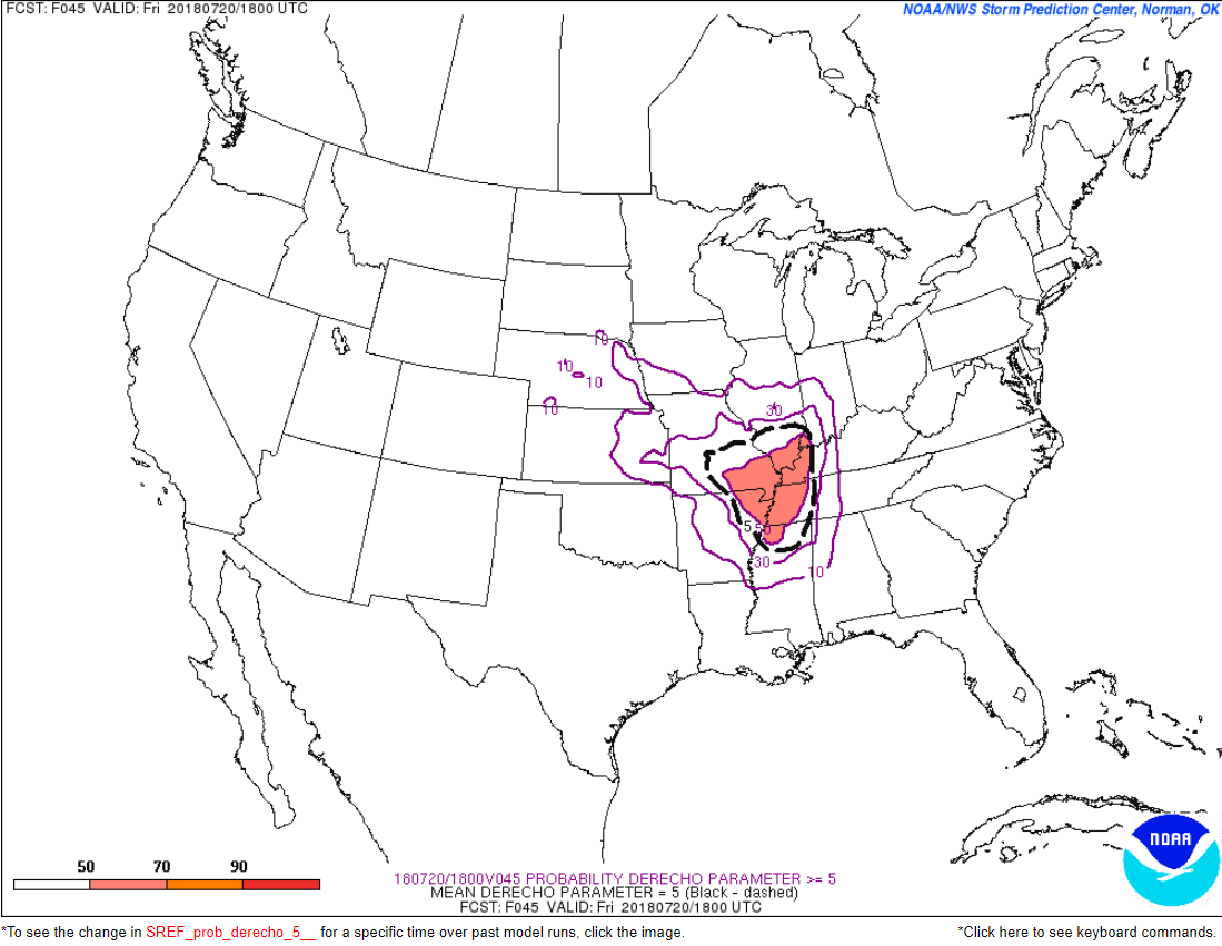
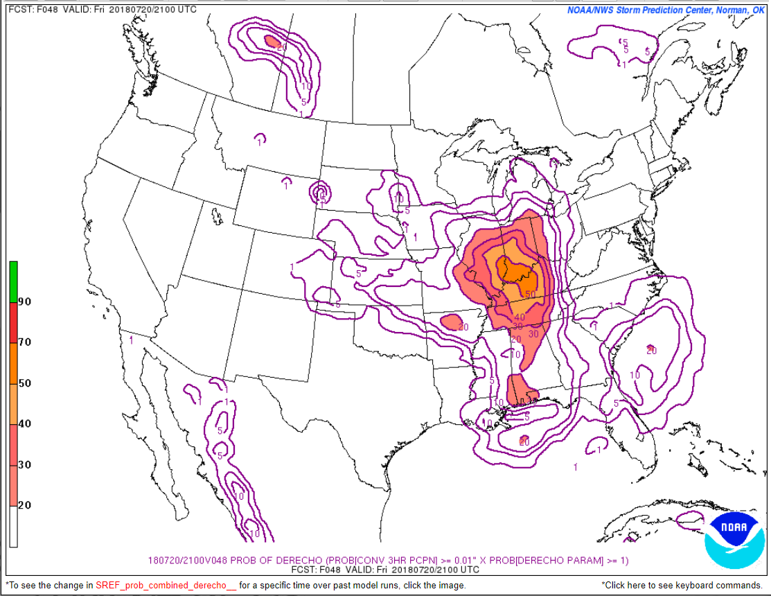
Guidance also shows the potential of a derecho forming. A derecho is a long lived line of thunderstorms that produces numbers reports of damaging winds. We had one a couple of weeks ago. It moved in from the north and northwest, as well.
Storms on Friday will be moving south and southeast.
Here is the derecho forecast numbers. Basically, this is showing a signal for the possibility of a line of thunderstorms Friday with damaging wind gusts.
This model blend has the system a bit further west than the Storm Prediction Center. There is some discussion about the placement of the severe thunderstorm potential.
Nothing is set in stone, just yet. Monitor updated forecasts.
I would recommend everyone stay updated on the latest weather information as this unfolds. We may have a busy 24 to 36 hours ahead.
Saturday into Wednesday should be somewhat less humid. Still warm, but perhaps not as hot as recent weeks. There will be a daily chance of spotty summer-type thunderstorms.
The July forecast has been updated. The heat will likely be the big story.
Outlook definitions
EQ = Equal chances of above or below normal
BN= Below normal
M/BN = Much below normal
AN = Above normal
M/AN = Much above normal
E/AN = Extremely above normal.
Normal high temperatures for this time of the year are around 88 degrees.
Normal low temperatures for this time of the year are around 65 degrees.
Normal precipitation during this time period ranges from 0.60″ to 0.80″
This outlook covers June 12th through June 18th
These graphics are for subscribers.
Subscribe at www.weathertalk.com

These graphics are for subscribers.
The precipitation forecast is PERCENT OF NORMAL. For example, if your normal rainfall is 1.00″ and the graphic shows 10%, then that would mean 0.10″ of rain is anticipated.
These graphics are for subscribers.
Subscribe at www.weathertalk.com

This outlook covers June 22nd through July 5th
These graphics are for subscribers.
Subscribe at www.weathertalk.com
And precipitation
These graphics are for subscribers.
Subscribe at www.weathertalk.com
June temperature and precipitation outlook
These graphics are for subscribers.
Subscribe at www.weathertalk.com

Outlook definitions
EQ = Equal chances of above or below normal
BN= Below normal
M/BN = Much below normal
AN = Above normal
M/AN = Much above normal
E/AN = Extremely above normal.
Temperature outlook for April through June.
These graphics are for subscribers.
Subscribe at www.weathertalk.com
Precipitation outlook for March through May.
These graphics are for subscribers.
Subscribe at www.weathertalk.com
Temperature outlook for June through August.
These graphics are for subscribers.
Subscribe at www.weathertalk.com
July temperature and precipitation outlook
These graphics are for subscribers.
Subscribe at www.weathertalk.com
August temperature and precipitation outlook
These graphics are for subscribers.
Subscribe at www.weathertalk.com
![]()

A new weather podcast is now available! Weather Geeks (which you might remember is on The Weather Channel each Sunday)
To learn more visit their website. Click here.
![]()

WeatherBrains Episode 652
Tonight’s Guest WeatherBrain is a meteorologist at the Naval Research Laboratory. Dr. David Peterson, welcome to WeatherBrains!
Last year was a record year for wildfires across the globe, and their impact on the atmosphere remains highly uncertain. Thanks to new research from expert scientists at the U.S. Naval Research Laboratory, the world is gaining more insight into what drives these massive and escalating events. NRL meteorologist Dr. Peterson explained his findings from his recent research, “Wildfire-Driven Thunderstorms Cause a Volcano-Like Stratospheric Injection of Smoke,” during a press conference at the European Geosciences Union’s annual General Assembly in Vienna, Austria, held from April 8 to 13. “Our research shows that the stratospheric impact from five wildfire-driven thunderstorms, known as pyrocumulonimbus or pyroCb, was comparable to a moderate volcanic eruption,” Peterson explained the NRL pryoCb research team’s findings and that it’s an interdisciplinary collaboration with scientists from both the Marine Meteorology and Remote Sensing Divisions within NRL. The significance of volcanic eruptions in the climate system has been recognized for several decades, but pyroCb research is relatively new, originating at NRL in the early 2000s, according to Peterson.
Other discussions in this weekly podcast include topics like:
- Extremes: 120 at Death Valley, CA, and 41 at Naples, ID
- NASA Sponsored Joint Korea/US Air Quality Campaign
- Birmingham reached 105F on this date in 1980
- Tropics all quiet in Atlantic basin
- Astronomy Outlook with Tony Rice
- and more!
Link https://weatherbrains.com/
Previous episodes can be viewed by clicking here.
We offer interactive local city live radars and regional radars. If a radar does not update then try another one. If a radar does not appear to be refreshing then hit Ctrl F5. You may also try restarting your browser.
The local city view radars also have clickable warnings.
During the winter months, you can track snow and ice by clicking the winterize button on the local city view interactive radars.
You may email me at beaudodson@usawx.com
Find me on Facebook!

Find me on Twitter!

Did you know that a portion of your monthly subscription helps support local charity projects?
You can learn more about those projects by visiting the Shadow Angel Foundation website and the Beau Dodson News website.

I encourage subscribers to use the app vs regular text messaging. We have found text messaging to be delayed during severe weather. The app typically will receive the messages instantly. I recommend people have three to four methods of receiving their severe weather information.
Remember, my app and text alerts are hand typed and not computer generated. You are being given personal attention during significant weather events.
