For $3 a month you can receive the following. You may choose to receive these via your WeatherTalk app or regular text messaging.
- Severe weather app/text alerts from my keyboard to your app/cell phone. These are hand typed by Beau. During tornado outbreaks, you will receive numerous app/text messages telling you exactly where the tornado is located.
- Daily forecast app/texts from my computer to your app/cell phone.
- Social media links sent directly to your app/cell phone. When I update the blog, videos, or Facebook you will receive the link.
- AWARE emails. These emails keep you well ahead of the storm. They give you several days of lead time before significant weather events.
- Direct access to Beau via text and email. Your very own personal meteorologist. I work for you!
- Missouri and Ohio Valley centered video updates
- Long-range weather videos
- Week one, two, three and four temperature and precipitation outlooks.
- Monthly outlooks.
- Your subscription also will help support several local charities.
Haven’t you subscribed? Subscribe at www.beaudodsonweather.com

I encourage subscribers to use the app vs regular text messaging. We have found text messaging to be delayed during severe weather. The app typically will receive the messages instantly. I recommend people have three to four methods of receiving their severe weather information.
Remember, my app and text alerts are hand typed and not computer generated. You are being given my personal attention during significant weather events.

WWW.WEATHERTALK.COM subscribers, here is my day to day schedule for your weather products.


We offer interactive local city live radars and regional radars. If a radar does not update then try another one. If a radar does not appear to be refreshing then hit Ctrl F5. You may also try restarting your browser.

.
July 11, 2018
Wednesday Forecast Details
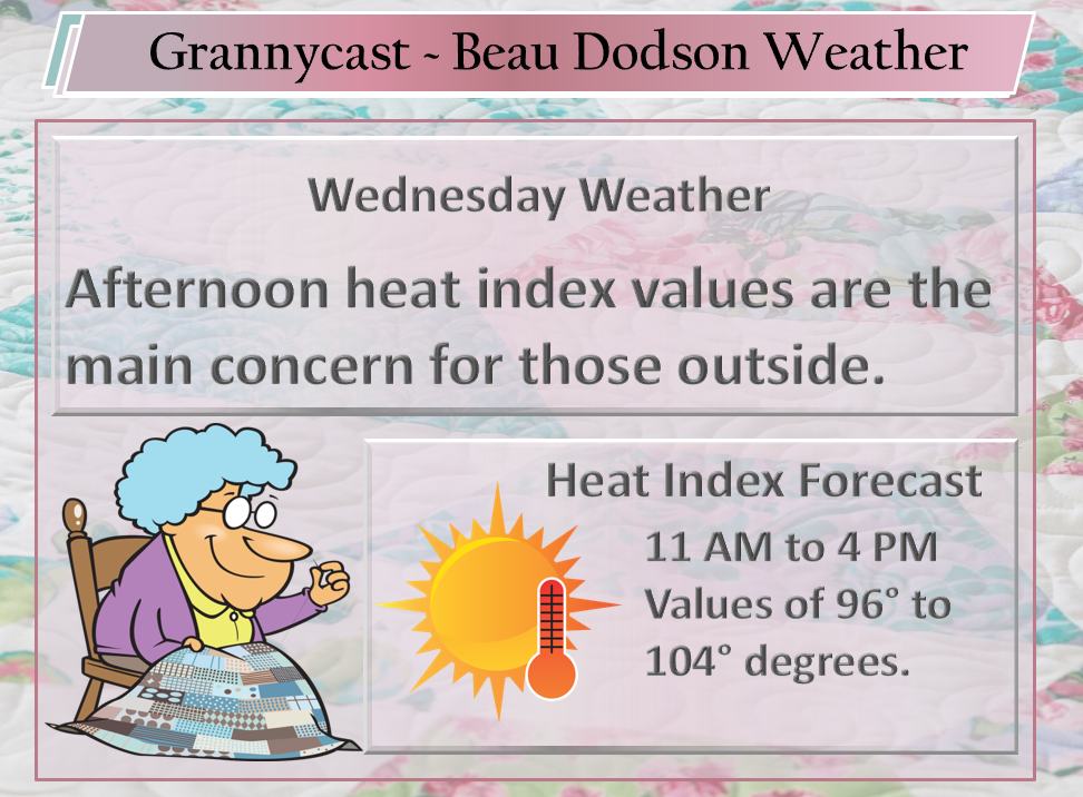
Forecast: Partly to mostly sunny. Some cumulus clouds. Isolated to widely scattered thunderstorms. Hot and humid. Heat index 96 to 102 degrees.
Temperatures: MO ~ 88 to 94 IL ~ 88 to 94 KY ~ 88 to 94 TN ~ 88 to 94
What is the chance of precipitation? MO ~ 20% IL ~ 20% KY ~ 30% TN ~ 30%
Coverage of precipitation: Isolated to widely scattered
Wind: Northeast at 5 to 10 mph
What impacts are anticipated from the weather? Wet roads, lightning, gusty winds near storms.
My confidence in the forecast verifying: High
Is severe weather expected? Summer storms can produce isolated damaging winds and torrential rain
The NWS defines severe weather as 58 mph wind or great, 1″ hail or larger, and/or tornadoes
Should I cancel my outdoor plans? No
UV Index: 9 to 10 High
Sunrise: 5:43 AM
Wednesday Night Forecast Details:
Forecast: Mostly clear. Warm and humid. Isolated evening storms possible.
Temperatures: MO ~ 70 to 73 IL ~ 66 to 72 KY ~ 70 to 72 TN ~ 70 to 73
What is the chance of precipitation? MO ~ 10% IL ~ 10% KY ~ 20% TN ~ 20%
Coverage of precipitation: Isolated.
Wind: Light winds
What impacts are anticipated from the weather? Isolated wet roadways, lightning, and gusty winds.
My confidence in the forecast verifying: High
Is severe weather expected? Summer thunderstorms can occasionally produce pockets of high winds and hail.
The NWS defines severe weather as 58 mph wind or great, 1″ hail or larger, and/or tornadoes
Should I cancel my outdoor plans? No
Sunset: 8:17 PM
Moonrise: 4:12 AM Waning Crescent
Moonset: 6:57 PM
July 12, 2018
Thursday Forecast Details
Forecast: Mostly sunny. Isolated to widely scattered thunderstorms possible. Not as humid over southern Illinois and northwest Kentucky. Muggier as you move south and west through the region. We will have to see how south and west the front pushes.
Temperatures: MO ~ 88 to 94 IL ~ 88 to 94 KY ~ 88 to 94 TN ~ 88 to 94
What is the chance of precipitation? MO ~ 10% to 20% IL ~ 10% to 20% KY ~ 10% to 20% TN ~ 10% to 20%
Coverage of precipitation: None to isolated
Wind: Northeast at 5 to 10 mph
What impacts are anticipated from the weather? None to isolated wet roads, lightning, gusty winds.
My confidence in the forecast verifying: High
Is severe weather expected? Summer storms can produce isolated damaging winds and torrential rain
The NWS defines severe weather as 58 mph wind or great, 1″ hail or larger, and/or tornadoes
Should I cancel my outdoor plans? No
UV Index: 9 to 10 High
Sunrise: 5:44 AM
Thursday Night Forecast Details:
Forecast: Mostly clear.
Temperatures: MO ~ 70 to 73 IL ~ 66 to 73 KY ~ 66 to 73 TN ~ 70 to 73
What is the chance of precipitation? MO ~ 10% to 20% IL ~ 10% to 20% KY ~ 10% to 20% TN ~ 10% to 20%
Coverage of precipitation: None to isolated.
Wind: Light and variable wind becoming east and southeast at 5 mph
What impacts are anticipated from the weather? None to isolated wet roadways, lightning, and gusty winds.
My confidence in the forecast verifying: High
Is severe weather expected? Summer thunderstorms can occasionally produce pockets of high winds and hail.
The NWS defines severe weather as 58 mph wind or great, 1″ hail or larger, and/or tornadoes
Should I cancel my outdoor plans? No
Sunset: 8:16 PM
Moonrise: 5:11 AM Waning Crescent
Moonset: 8:00 PM
July 13, 2018
Friday Forecast Details
Forecast: Mostly sunny. Hot. We will have to see how far southwest the front pushes. Lower dew points north and east of the front. Higher dew points south and west.
Temperatures: MO ~ 92 to 95 IL ~ 90 to 95 KY ~ 90 to 95 TN ~ 90 to 95
What is the chance of precipitation? MO ~ 10% to 20% IL ~ 10% to 20% KY ~ 10% to 20% TN ~ 10% to 20%
Coverage of precipitation: None to isolated
Wind: Southeast at 5 to 10 mph
What impacts are anticipated from the weather? None to isolated wet roads, lightning, gusty winds.
My confidence in the forecast verifying: Medium
Is severe weather expected? Summer storms can produce isolated damaging winds and torrential rain
The NWS defines severe weather as 58 mph wind or great, 1″ hail or larger, and/or tornadoes
Should I cancel my outdoor plans? No
UV Index: 9 to 10 High
Sunrise: 5:45 AM
Friday Night Forecast Details:
Forecast: Mostly clear. Warm and humid.
Temperatures: MO ~ 70 to 74 IL ~ 70 to 74 KY ~ 70 to 74 TN ~ 72 to 75
What is the chance of precipitation? MO ~ 10% to 20% IL ~ 10% to 20% KY ~ 10% to 20% TN ~ 10% to 20%
Coverage of precipitation: None to isolated.
Wind: Southeast at 4 to 8 mph
What impacts are anticipated from the weather? None to isolated wet roadways, lightning, and gusty winds.
My confidence in the forecast verifying: Medium
Is severe weather expected? Summer thunderstorms can occasionally produce pockets of high winds and hail.
The NWS defines severe weather as 58 mph wind or great, 1″ hail or larger, and/or tornadoes
Should I cancel my outdoor plans? No
Sunset: 8:16 PM
Moonrise: 6:17 AM New Moon
Moonset: 8:57 PM
July 14, 2018
Saturday Forecast Details
Forecast: Mostly sunny. Hot and humid. Heat index 100 to 106. An isolated thunderstorm possible.
Temperatures: MO ~ 92 to 96 IL ~ 92 to 96 KY ~ 92 to 96 TN ~ 92 to 96
What is the chance of precipitation? MO ~ 20% IL ~ 20% KY ~ 20% TN ~ 20%
Coverage of precipitation: None to isolated
Wind: South at 5 to 10 mph
What impacts are anticipated from the weather? None to isolated wet roads, lightning, gusty winds.
My confidence in the forecast verifying: Medium
Is severe weather expected? Summer storms can produce isolated damaging winds and torrential rain
The NWS defines severe weather as 58 mph wind or great, 1″ hail or larger, and/or tornadoes
Should I cancel my outdoor plans? No, but check radars
UV Index: 9 to 10 High
Sunrise: 5:45 AM
Saturday Night Forecast Details:
Forecast: Mostly clear. Warm and humid. An isolated evening storm.
Temperatures: MO ~ 72 to 75 IL ~ 70 to 74 KY ~ 72 to 75 TN ~ 72 to 75
What is the chance of precipitation? MO ~ 20% IL ~ 20% KY ~ 20% TN ~ 20%
Coverage of precipitation: None to isolated.
Wind: South at 4 to 8 mph
What impacts are anticipated from the weather? None to isolated wet roadways, lightning, and gusty winds.
My confidence in the forecast verifying: Medium
Is severe weather expected? Summer thunderstorms can occasionally produce pockets of high winds and hail.
The NWS defines severe weather as 58 mph wind or great, 1″ hail or larger, and/or tornadoes
Should I cancel my outdoor plans? No, but check evening radars
Sunset: 8:15 PM
Moonrise: 7:28 AM Waxing Crescent
Moonset: 9:47 PM
July 15, 2018
Sunday Forecast Details
Forecast: Mostly sunny. Hot and humid. Heat index 100 to 106. Widely scattered thunderstorms possible.
Temperatures: MO ~ 92 to 96 IL ~ 92 to 96 KY ~ 92 to 96 TN ~ 92 to 96
What is the chance of precipitation? MO ~ 30% IL ~ 30% KY ~ 30% TN ~ 30%
Coverage of precipitation: Widely scattered
Wind: Southwest at 5 to 10 mph
What impacts are anticipated from the weather? Wet roads, lightning, gusty winds.
My confidence in the forecast verifying: Medium
Is severe weather expected? Summer storms can produce isolated damaging winds and torrential rain
The NWS defines severe weather as 58 mph wind or great, 1″ hail or larger, and/or tornadoes
Should I cancel my outdoor plans? No, but check radars
UV Index: 9 to 10 High
Sunrise: 5:46 AM
Sunday Night Forecast Details:
Forecast: Mostly clear. Warm and humid. An isolated evening thunderstorm.
Temperatures: MO ~ 72 to 76 IL ~ 72 to 76 KY ~ 72 to 76 TN ~ 74 to 76
What is the chance of precipitation? MO ~ 20% IL ~ 20% KY ~ 20% TN ~ 20%
Coverage of precipitation: None to isolated.
Wind: South at 4 to 8 mph
What impacts are anticipated from the weather? None to isolated wet roadways, lightning, and gusty winds.
My confidence in the forecast verifying: Medium
Is severe weather expected? Summer thunderstorms can occasionally produce pockets of high winds and hail.
The NWS defines severe weather as 58 mph wind or great, 1″ hail or larger, and/or tornadoes
Should I cancel my outdoor plans? No, but check evening radars
Sunset: 8:15 PM
Moonrise: 8:40 AM Waxing Crescent
Moonset: 10:30 PM
July 16, 2018
Monday Forecast Details
Forecast: Partly sunny. Warm. Scattered thunderstorms.
Temperatures: MO ~ 88 to 92 IL ~ 88 to 92 KY ~ 88 to 92 TN ~ 88 to 92
What is the chance of precipitation? MO ~ 40% IL ~ 40% KY ~ 40% TN ~ 40%
Coverage of precipitation: Scattered
Wind: Northwest at 5 to 10 mph
What impacts are anticipated from the weather? Wet roads, lightning, gusty winds.
My confidence in the forecast verifying: Medium
Is severe weather expected? Summer storms can produce isolated damaging winds and torrential rain
The NWS defines severe weather as 58 mph wind or great, 1″ hail or larger, and/or tornadoes
Should I cancel my outdoor plans? No, but check radars
UV Index: 9 to 10 High
Sunrise: 5:47 AM
Monday Night Forecast Details:
Forecast: Partly cloudy. Scattered thunderstorms.
Temperatures: MO ~ 66 to 72 IL ~ 66 to 72 KY ~ 66 to 72 TN ~ 66 to 72
What is the chance of precipitation? MO ~ 40% IL ~ 40% KY ~ 40% TN ~ 40%
Coverage of precipitation: Scattered
Wind: Northwest at 5 to 10 mph
What impacts are anticipated from the weather? Wet roadways, lightning, and gusty winds.
My confidence in the forecast verifying: Medium
Is severe weather expected? Summer thunderstorms can occasionally produce pockets of high winds and hail.
The NWS defines severe weather as 58 mph wind or great, 1″ hail or larger, and/or tornadoes
Should I cancel my outdoor plans? No, but check evening radars
Sunset: 8:14 PM
Moonrise: 9:50 AM Waxing Crescent
Moonset: 11:08 PM
Learn more about the UV index readings. Click here.

A fairly typical weather pattern for our local area.
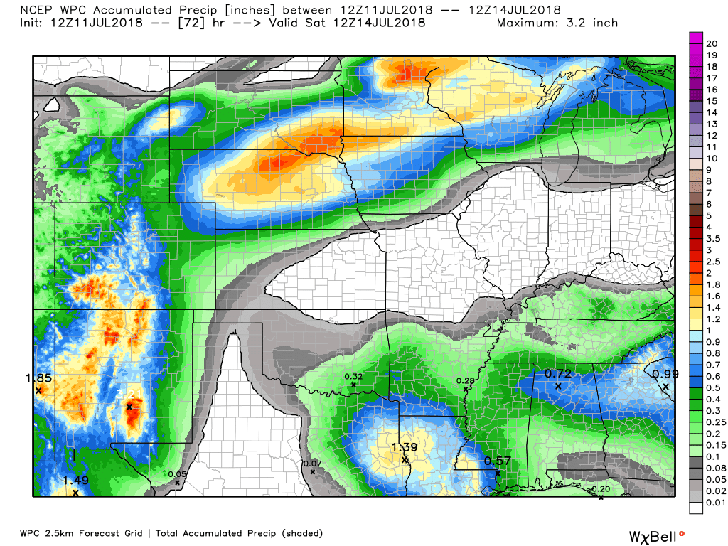
Here is the latest WPC / NOAA
This graphic will not cover those wild swings in rainfall totals that occur from locally heavy thunderstorms. These number will be greatly underdone where slow moving thunderstorms occur.
These are forecast rain totals through Saturday morning.
Again, thunderstorms can always produce much higher totals.
Let’s look at the seven day rainfall forecast. Rain chances increase Sunday through Tuesday. Some heavy storms are possible.
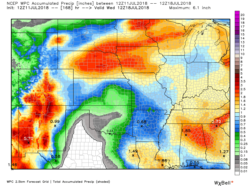
I did increase storm chances today. Mostly over far southeast Missouri, extreme southern Illinois, and western Kentucky.
.

We offer interactive local city live radars and regional radars. If a radar does not update then try another one.
If a radar does not appear to be refreshing then hit Ctrl F5 on your keyboard.
You may also try restarting your browser.
The local city view radars also have clickable warnings.
During the winter months, you can track snow and ice by clicking the winterize button on the local city view interactive radars.

Questions? Broken links? Other questions?
You may email me at beaudodson@usawx.com

The National Weather Service defines a severe thunderstorm as one that produces quarter size hail or larger, 58 mph winds or greater, and/or a tornado.
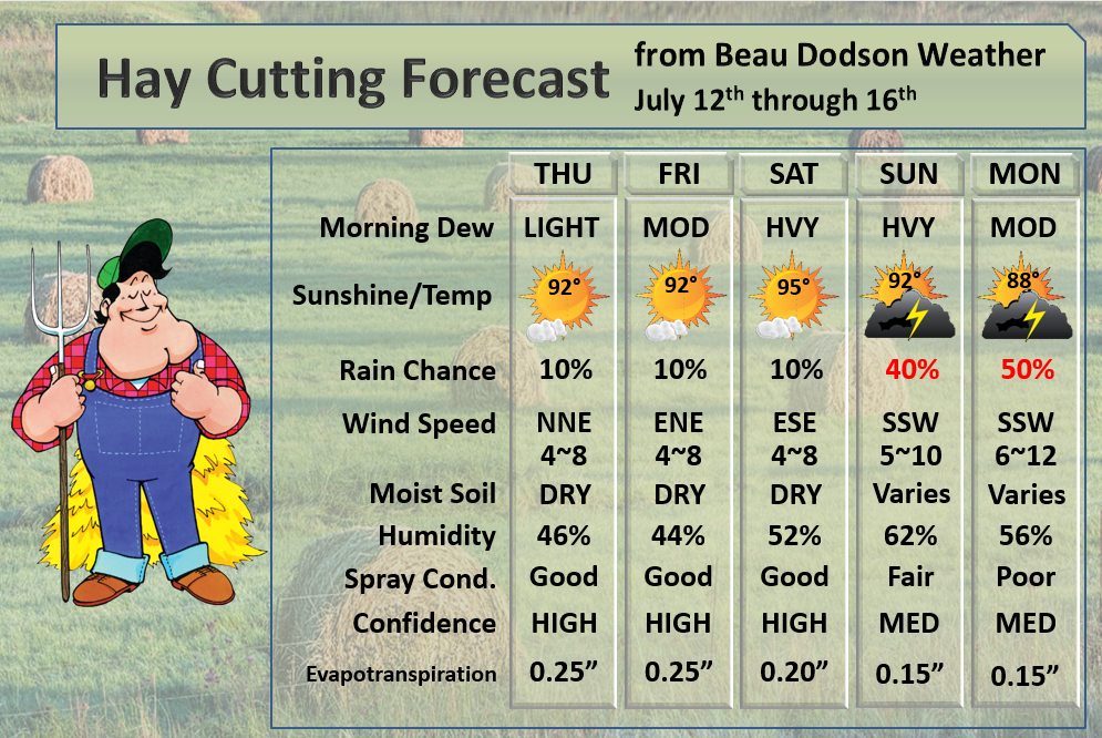
Wednesday through Saturday. A few scattered thunderstorms today. Storm chances Thursday into Saturday will be low. Any storms that form would be intense with gusty winds, torrential rain, and lightning, Pea size hail, as well. Many areas will remain dry.
Sunday into next week: There are some indications we may have a few rounds of thunderstorms as we push into next week. Monitor updates.
Summer thunderstorms can produce isolated microbursts.
microburst winds can exceed 50 mph.
What are microbursts?

Interactive live weather radar page. Choose the city nearest your location. If one of the cities does not work then try a nearby one. Click here.
National map of weather watches and warnings. Click here.
Storm Prediction Center. Click here.
Weather Prediction Center. Click here.

Live lightning data: Click here.

Interactive GOES R satellite. Track clouds. Click here.

Here are the latest local river stage forecast numbers Click Here.
Here are the latest lake stage forecast numbers for Kentucky Lake and Lake Barkley Click Here.

The summer outlook have been posted for subscribers. Scroll down to see the outlook.Not a subscriber? Learn more at this link.

Weather Headlines
- The heat
- Dew point changes over the next 36 hours
- Monitoring next week
Am I sounding like a broken record, yet? More heat and high dew points today.
Remember, dew points control how muggy it feels outside. Dew points will be in the 70’s today.
The good news is that a cold front will slide into PORTIONS of the region tonight and Thursday. This front will mean lower dew points for portions of the region. It appears the greatest change will be across southern Illinois and northwest Kentucky. That means it will feel somewhat nicer outside. Not perfect, but better.
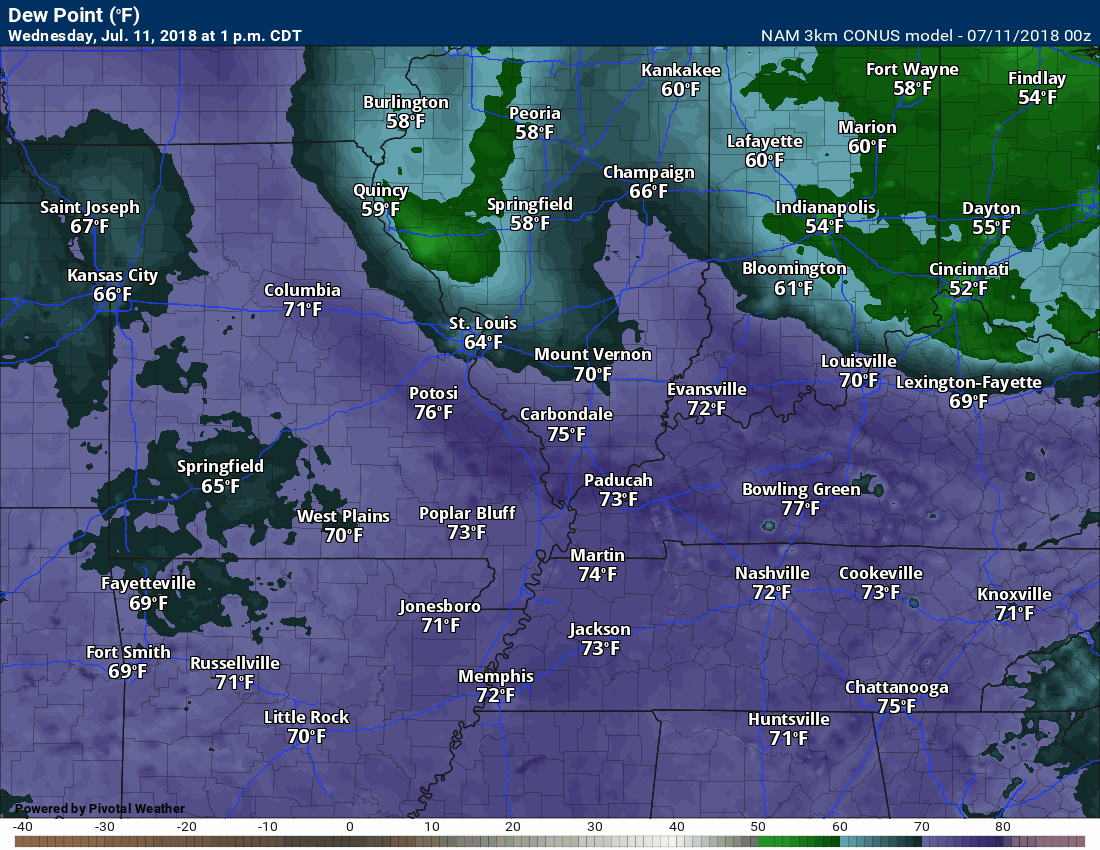
I showed you the dew point map yesterday.
The NAM 3K model is bullish about pushing the nicer dew points further southwest. We can hope.
Here is the animation of dew points.
The front will help support a few scattered thunderstorms today. Where storms form they will produce heavy rain and gusty winds. Lightning, as well.
The best chance of rain will be across far southeast Missouri into western Kentucky/northwest Tennessee (perhaps far southern Illinois, as well).
Here is the Hrrr high resolution model guidance future-cast radar. What radar might look like today. Notice the placement of the thunderstorm activity is across the southern half of the region.

Many areas will remain dry today, but a few spots will pick up a quick 0.50″+ of rainfall.
I have received little rainfall since the first of the month at the Weather Observatory in Massac County, Illinois.
Here are my rainfall totals since the end of June

Thursday into Saturday will be mostly dry. The atmosphere may be capped. That means a warm layer of air aloft that helps prevent thunderstorms from forming.
Next Week
The weather will become more unsettled as northwest flow develops next week.
What is northwest flow?
It is when the main steering currents become northwest. That means thunderstorm complexes would move northwest to southeast.
Here is the 500 mb chart. Notice how the jet stream arrows are diving into our region from the northwest?
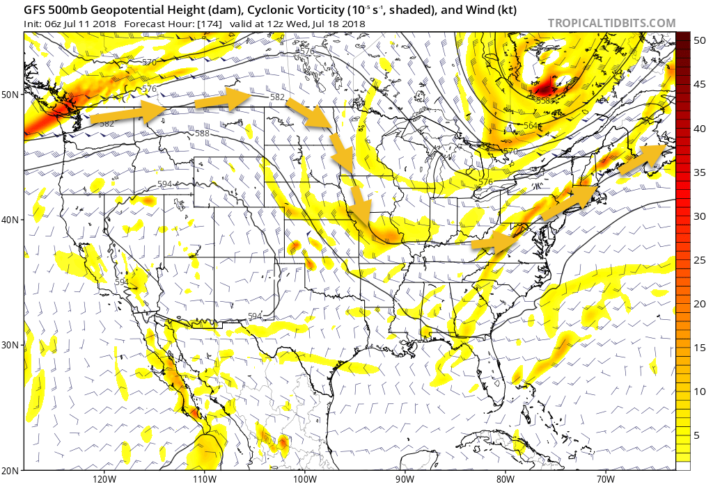
Wind shear (change of direction and speed with height) will be fairly light Sunday into Tuesday. That would limit the risk of severe thunderstorms. I can’t rule out isolated reports of wind damage. Thunderstorms will be towering above 50,000 feet and that is quite a bit of energy to work with.
I will likely increase thunderstorm chances to 40% and above Monday into at least Tuesday. The thunderstorm chances may last well into next week.
I am going to monitor for MCS’s next week. Those are large thunderstorm complexes that form during the summer months. They can produce heavier rain totals and damaging wind. Plenty of lightning, as well. They typically do require a bit more jet stream support.
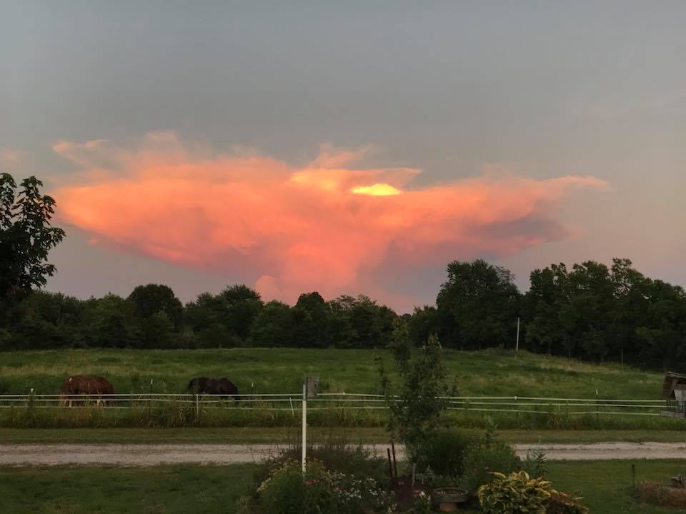
A few thunderstorms pushed across southeast Illinois (and other areas) Tuesday.
This is one of the thunderstorms. Photographer Mila Maring-Sims.
The heat will continue to be an issue for senior citizens, small children, and those working outside.
![]()
Outlook definitions
EQ = Equal chances of above or below normal
BN= Below normal
M/BN = Much below normal
AN = Above normal
M/AN = Much above normal
E/AN = Extremely above normal.
Normal high temperatures for this time of the year are around 88 degrees.
Normal low temperatures for this time of the year are around 65 degrees.
Normal precipitation during this time period ranges from 0.60″ to 0.80″
This outlook covers June 12th through June 18th
These graphics are for subscribers.
Subscribe at www.weathertalk.com

These graphics are for subscribers.
The precipitation forecast is PERCENT OF NORMAL. For example, if your normal rainfall is 1.00″ and the graphic shows 10%, then that would mean 0.10″ of rain is anticipated.
These graphics are for subscribers.
Subscribe at www.weathertalk.com

This outlook covers June 22nd through July 5th
These graphics are for subscribers.
Subscribe at www.weathertalk.com
And precipitation
These graphics are for subscribers.
Subscribe at www.weathertalk.com
June temperature and precipitation outlook
These graphics are for subscribers.
Subscribe at www.weathertalk.com

Outlook definitions
EQ = Equal chances of above or below normal
BN= Below normal
M/BN = Much below normal
AN = Above normal
M/AN = Much above normal
E/AN = Extremely above normal.
Temperature outlook for April through June.
These graphics are for subscribers.
Subscribe at www.weathertalk.com
Precipitation outlook for March through May.
These graphics are for subscribers.
Subscribe at www.weathertalk.com
Temperature outlook for June through August.
These graphics are for subscribers.
Subscribe at www.weathertalk.com
July temperature and precipitation outlook
These graphics are for subscribers.
Subscribe at www.weathertalk.com
August temperature and precipitation outlook
These graphics are for subscribers.
Subscribe at www.weathertalk.com
![]()

A new weather podcast is now available! Weather Geeks (which you might remember is on The Weather Channel each Sunday)
To learn more visit their website. Click here.
![]()

WeatherBrains Episode 650
Joining us as Guest WeatherBrains this week we have Ariel Cohen and Ryan Bunker from NWS Topeka, KS. Ariel is the Science and Operations Officer (SOO) at WFO Topeka. They bring a whole host of additional people to the show. They will be discussing the topic of mentorship and career advancement.
Kevin Selle invited Aubrey’s partner in crime while in Norman last week to the show, so joining us from WOOD-TV, Grand Rapids, as our Guest Panelist we have Ellen Bacca.
Other discussions in this weekly podcast include topics like:
- Extremes: 119 at Death Valley, CA, and 31 at Leadville, CO
- Westerlies pushed north along US/Canadian border
- Severe weather west of Great Lakes next couple of days
- Hot in Southwest US and along coast from VA to ME
- Highest drought conditions in Southwest US
- Astronomy Outlook with Tony Rice
- and more!
No video this week. There is audio.
Link https://weatherbrains.com/
Previous episodes can be viewed by clicking here.
We offer interactive local city live radars and regional radars. If a radar does not update then try another one. If a radar does not appear to be refreshing then hit Ctrl F5. You may also try restarting your browser.
The local city view radars also have clickable warnings.
During the winter months, you can track snow and ice by clicking the winterize button on the local city view interactive radars.
You may email me at beaudodson@usawx.com
Find me on Facebook!

Find me on Twitter!

Did you know that a portion of your monthly subscription helps support local charity projects?
You can learn more about those projects by visiting the Shadow Angel Foundation website and the Beau Dodson News website.

I encourage subscribers to use the app vs regular text messaging. We have found text messaging to be delayed during severe weather. The app typically will receive the messages instantly. I recommend people have three to four methods of receiving their severe weather information.
Remember, my app and text alerts are hand typed and not computer generated. You are being given personal attention during significant weather events.
