
We offer interactive local city live radars and regional radars. If a radar does not update then try another one. If a radar does not appear to be refreshing then hit Ctrl F5. You may also try restarting your browser.

.
July 14, 2018
Saturday Forecast Details
** I did increase rain chances just a little bit today. I had them at 20%. I raised them to 20% to 30% across southeast Missouri and southern Illinois. I kept them at 20% across the rest of the area. Expect some isolated to widely scattered thunderstorms on radar today. A few locations will pick up torrential downpours in slow moving thunderstorms. Many areas will remain dry **
Forecast: Partly to mostly sunny. Scattered locally heavy thunderstorms. Hot and muggy. Heat index 100 to 108 degrees. Locally heavy rain where storms occur. Many areas will remain dry. A few locations will pick up a gully washer from slow moving thunderstorms.
Temperatures: MO ~ 92 to 96 IL ~ 92 to 96 KY ~ 92 to 96 TN ~ 92 to 96
What is the chance of precipitation? MO ~ 40% IL ~ 40% KY ~ 30% TN ~ 20% to 30%
Coverage of precipitation: Scattered.
Wind: South at 5 to 10 mph
What impacts are anticipated from the weather? High heat index values will make it uncomfortable outside. Senior citizens, children, and those working outdoors will experience some problems with the heat. Scattered heavy rain, wet roads, lightning, gusty winds.
My confidence in the forecast verifying: High
Is severe weather expected? Summer storms can produce isolated damaging winds and torrential rain
The NWS defines severe weather as 58 mph wind or great, 1″ hail or larger, and/or tornadoes
Should I cancel my outdoor plans? No, but check radar if skies darken. Some storms will dot radar today.
UV Index: 9 to 10 High
Sunrise: 5:45 AM
RADAR LINK
We offer interactive local city live radars and regional radars. If a radar does not update then try another one.
Saturday Night Forecast Details:
Forecast: Mostly clear. Warm and humid. Scattered thunderstorms possible. Locally heavy rain where storms occur.
Temperatures: MO ~ 73 to 76 IL ~ 73 to 76 KY ~ 73 to 76 TN ~ 73 to 76
What is the chance of precipitation? MO ~ 30% to 40% IL ~ 30% to 40% KY ~ 30% to 40% TN ~ 20%
Coverage of precipitation: Scattered
Wind: South at 4 to 8 mph
What impacts are anticipated from the weather? Scattered wet roadways, lightning, and gusty winds. Heavy rain where storms occur.
My confidence in the forecast verifying: Medium
Is severe weather expected? Summer thunderstorms can occasionally produce pockets of high winds and hail.
The NWS defines severe weather as 58 mph wind or great, 1″ hail or larger, and/or tornadoes
Should I cancel my outdoor plans? No, but check radars.
Sunset: 8:15 PM
Moonrise: 7:28 AM Waxing Crescent
Moonset: 9:47 PM
July 15, 2018
Sunday Forecast Details
Forecast: A mix of sun and clouds. Hot and humid. Heat index 100 to 106. Scattered heavy thunderstorms.
Temperatures: MO ~ 92 to 96 IL ~ 92 to 96 KY ~ 92 to 96 TN ~ 92 to 96
What is the chance of precipitation? MO ~ 40% to 50% IL ~ 40% to 50% KY ~ 40% to 50% TN ~ 40% to 50%
Coverage of precipitation: Scattered
Wind: Southwest at 5 to 10 mph
What impacts are anticipated from the weather? Wet roads, lightning, gusty winds. Heavy rain where storms occur.
My confidence in the forecast verifying: Medium
Is severe weather expected? Summer storms can produce isolated damaging winds and torrential rain
The NWS defines severe weather as 58 mph wind or great, 1″ hail or larger, and/or tornadoes
Should I cancel my outdoor plans? Check radars. Some storms will occur.
UV Index: 9 to 10 High
Sunrise: 5:46 AM
Sunday Night Forecast Details:
Forecast: Partly cloudy. Scattered showers and locally heavy thunderstorms.
Temperatures: MO ~ 72 to 76 IL ~ 72 to 76 KY ~ 72 to 76 TN ~ 74 to 76
What is the chance of precipitation? MO ~ 40% to 50% IL ~ 40% to 50% KY ~ 40% to 50% TN ~ 40% to 50%
Coverage of precipitation: Scattered
Wind: South and southwest at 4 to 8 mph
What impacts are anticipated from the weather? Wet roadways, lightning, and gusty winds. Heavy rain.
My confidence in the forecast verifying: Medium
Is severe weather expected? Summer thunderstorms can occasionally produce pockets of high winds and hail.
The NWS defines severe weather as 58 mph wind or great, 1″ hail or larger, and/or tornadoes
Should I cancel my outdoor plans? Check radars. There will be storms in the region.
Sunset: 8:15 PM
Moonrise: 8:40 AM Waxing Crescent
Moonset: 10:30 PM
July 16, 2018
Monday Forecast Details
Forecast: Partly sunny. Warm. Scattered thunderstorms. Some of the new data pushes the front through faster. If this occurs then rain chances decrease Monday. I will monitor forecast trends and update as necessary. Some storms will produce heavy rain and gusty winds. Frequent lightning, as well.
Temperatures: MO ~ 88 to 92 IL ~ 88 to 92 KY ~ 88 to 92 TN ~ 88 to 92
What is the chance of precipitation? MO ~ 30% to 40% IL ~ 40% to 50% KY ~ 50% to 60% TN ~ 50% to 60%
Coverage of precipitation: Scattered (again, this is dependent on the speed of the cold front exiting the region)
Wind: West and southwest at 5 to 10 mph
What impacts are anticipated from the weather? Wet roads, lightning, gusty winds. Locally heavy rain. Small hail.
My confidence in the forecast verifying: LOW
Is severe weather expected? A few storms could produce high winds and small hail.
The NWS defines severe weather as 58 mph wind or great, 1″ hail or larger, and/or tornadoes
Should I cancel my outdoor plans? Monitor updates and check radars. There will still be storms in the region.
UV Index: 8 to 9 High
Sunrise: 5:47 AM
Monday Night Forecast Details:
Forecast: Partly cloudy. Widely scattered thunderstorms. Locally heavy rain possible.
Temperatures: MO ~ 66 to 72 IL ~ 66 to 72 KY ~ 66 to 72 TN ~ 66 to 72
What is the chance of precipitation? MO ~ 40% IL ~ 40% KY ~ 40% TN ~ 40%
Coverage of precipitation: Widely scattered
Wind: Northwest at 5 to 10 mph
What impacts are anticipated from the weather? Wet roadways, lightning, and gusty winds. Locally heavy rain.
My confidence in the forecast verifying: Medium
Is severe weather expected? Monitor updates. A few strong thunderstorms are possible. The main concern would be damaging wind.
The NWS defines severe weather as 58 mph wind or great, 1″ hail or larger, and/or tornadoes
Should I cancel my outdoor plans? No, but check evening radars
Sunset: 8:14 PM
Moonrise: 9:50 AM Waxing Crescent
Moonset: 11:08 PM
July 17, 2018
Tuesday Forecast Details
Forecast: Partly to mostly sunny. Warm. A chance of widely scattered thunderstorms. It is possible Tuesday ends up dry. This will be determined by the speed of the cold frontal passage.
Temperatures: MO ~ 86 to 92 IL ~ 86 to 92 KY ~ 86 to 92 TN ~ 88 to 92
What is the chance of precipitation? MO ~ 20% (30% in the Bootheel) IL ~ 20% KY ~ 20% TN ~ 30%
Coverage of precipitation: Isolated to widely scattered.
Wind: Northwest at 5 to 10 mph
What impacts are anticipated from the weather? Perhaps wet roads, lightning, gusty winds.
My confidence in the forecast verifying: Medium
Is severe weather expected? Summer storms can produce isolated damaging winds and torrential rain
The NWS defines severe weather as 58 mph wind or great, 1″ hail or larger, and/or tornadoes
Should I cancel my outdoor plans? No, but check radars
UV Index: 9 to 10 High
Sunrise: 5:47 AM
Tuesday Night Forecast Details:
Forecast: Decreasing clouds. Becoming clear. Mild.
Temperatures: MO ~ 66 to 70 IL ~ 66 to 70 KY ~ 66 to 70 TN ~ 66 to 72
What is the chance of precipitation? MO ~ 10% IL ~ 10% KY ~ 10% TN ~ 10%
Coverage of precipitation: None to isolated early
Wind: Northwest at 5 to 10 mph
What impacts are anticipated from the weather? Most likely none
My confidence in the forecast verifying: Medium
Is severe weather expected? No
The NWS defines severe weather as 58 mph wind or great, 1″ hail or larger, and/or tornadoes
Should I cancel my outdoor plans? No
Sunset: 8:13 PM
Moonrise: 10:58 AM Waxing Crescent
Moonset: 11:42 PM
July 18, 2018
Wednesday Forecast Details
Forecast: Mostly sunny. Not as hot.
Temperatures: MO ~ 85 to 88 IL ~ 84 to 88 KY ~ 85 to 88 TN ~ 85 to 88
What is the chance of precipitation? MO ~ 10% IL ~ 10% KY ~ 10% TN ~ 10%
Coverage of precipitation: Most likely none
Wind: Northwest at 5 to 10 mph
What impacts are anticipated from the weather? Most likely none
My confidence in the forecast verifying: Medium
Is severe weather expected? No
The NWS defines severe weather as 58 mph wind or great, 1″ hail or larger, and/or tornadoes
Should I cancel my outdoor plans? No
UV Index: 9 to 10 High
Sunrise: 5:47 AM
Wednesday Night Forecast Details:
Forecast: Mostly clear. Mild.
Temperatures: MO ~ 66 to 72 IL ~ 66 to 72 KY ~ 66 to 72 TN ~ 66 to 72
What is the chance of precipitation? MO ~ 10% IL ~ 10% KY ~ 10% TN ~ 10%
Coverage of precipitation: Most likely none
Wind: North and northwest at 5 to 10 mph
What impacts are anticipated from the weather? Most likely none
My confidence in the forecast verifying: Medium
Is severe weather expected? No
The NWS defines severe weather as 58 mph wind or great, 1″ hail or larger, and/or tornadoes
Should I cancel my outdoor plans? No
Sunset: 8:13 PM
Moonrise: 10:58 AM Waxing Crescent
Moonset: 11:42 PM
Learn more about the UV index readings. Click here.

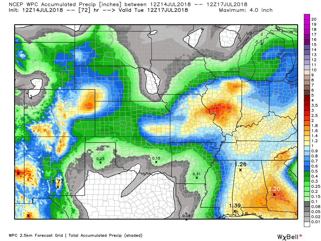
Here is the latest WPC / NOAA Rainfall charts
This graphic will not cover those wild swings in rainfall totals that occur from locally heavy thunderstorms. These number will be greatly underdone where slow moving thunderstorms occur.
These are forecast rain totals through Tuesday morning.
.

We offer interactive local city live radars and regional radars. If a radar does not update then try another one.
If a radar does not appear to be refreshing then hit Ctrl F5 on your keyboard.
You may also try restarting your browser.
The local city view radars also have clickable warnings.
During the winter months, you can track snow and ice by clicking the winterize button on the local city view interactive radars.

Questions? Broken links? Other questions?
You may email me at beaudodson@usawx.com

The National Weather Service defines a severe thunderstorm as one that produces quarter size hail or larger, 58 mph winds or greater, and/or a tornado.
Saturday and Saturday night. Scattered heavy thunderstorms. Any storms that form would be intense with gusty winds, torrential rain, and lightning, Pea size hail, as well. Much of the area will remain dry through Saturday evening. A few locations will experience a gully washer from slow moving thunderstorms.
Sunday into Monday night: Thunderstorm chances will increase Sunday. Scattered. Thunderstorm activity will become more numerous Sunday afternoon into Monday. This will occur along an incoming cold front.
A few of the storms could produce damaging wind, small hail, and torrential downpours. PWAT values (measure of moisture) will be extremely high Sunday night into Monday night. This would mean heavy rain totals.
There are some questions about how fast the front exits Monday afternoon. A faster moving front would shut rain chances down earlier.
Decreasing rain chances Tuesday and Wednesday. There are some guidance packages that show 20% to 30% thunderstorm chances Tuesday (mostly across the Missouri Bootheel into western Kentucky and northwest Tennessee). I will keep an eye on that time frame.
Thursday: Another cold front may bring thunderstorms back into the region.
Summer thunderstorms can produce isolated microbursts.
microburst winds can exceed 50 mph.
What are microbursts?

Interactive live weather radar page. Choose the city nearest your location. If one of the cities does not work then try a nearby one. Click here.
National map of weather watches and warnings. Click here.
Storm Prediction Center. Click here.
Weather Prediction Center. Click here.

Live lightning data: Click here.

Interactive GOES R satellite. Track clouds. Click here.

Here are the latest local river stage forecast numbers Click Here.
Here are the latest lake stage forecast numbers for Kentucky Lake and Lake Barkley Click Here.

The summer outlook have been posted for subscribers. Scroll down to see the outlook.Not a subscriber? Learn more at this link.

Weather Headlines
- High heat index values today. They could top 105 degrees.
- Slow moving thunderstorms could produce heavy rain.
- Increasing thunderstorm coverage Sunday into Monday. Locally heavy rain and gusty winds. Frequent lightning.
- Monitoring another cold front Thursday.
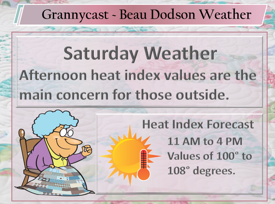
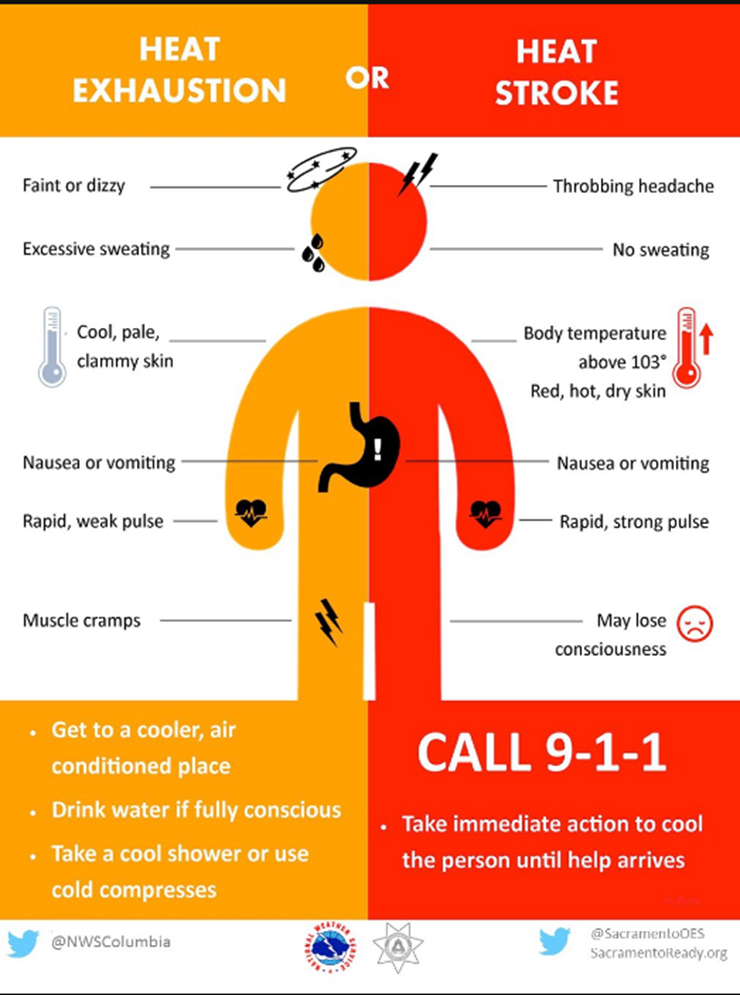
The main weather concern today will be the high heat index values. You can expect feel-like temperatures to range from 100 to 108 degrees. This is not just a made up number to make it feel hotter. This is what your body believes the temperature is. These type of heat index values can cause heat related illnesses. Use care, as always.
Actual air temperatures will range from 94 to 98 degrees.
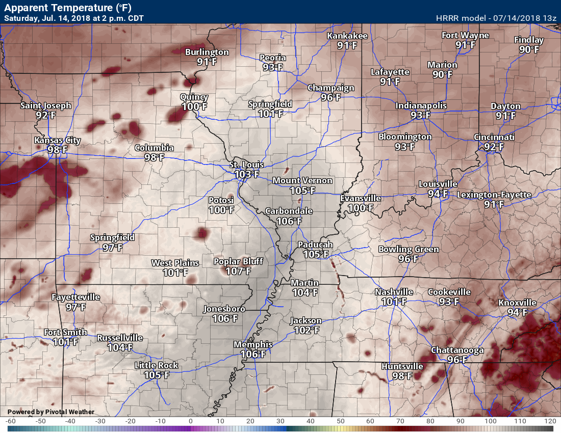
Here is the Hrrr model’s heat index forecast for 2 PM today.
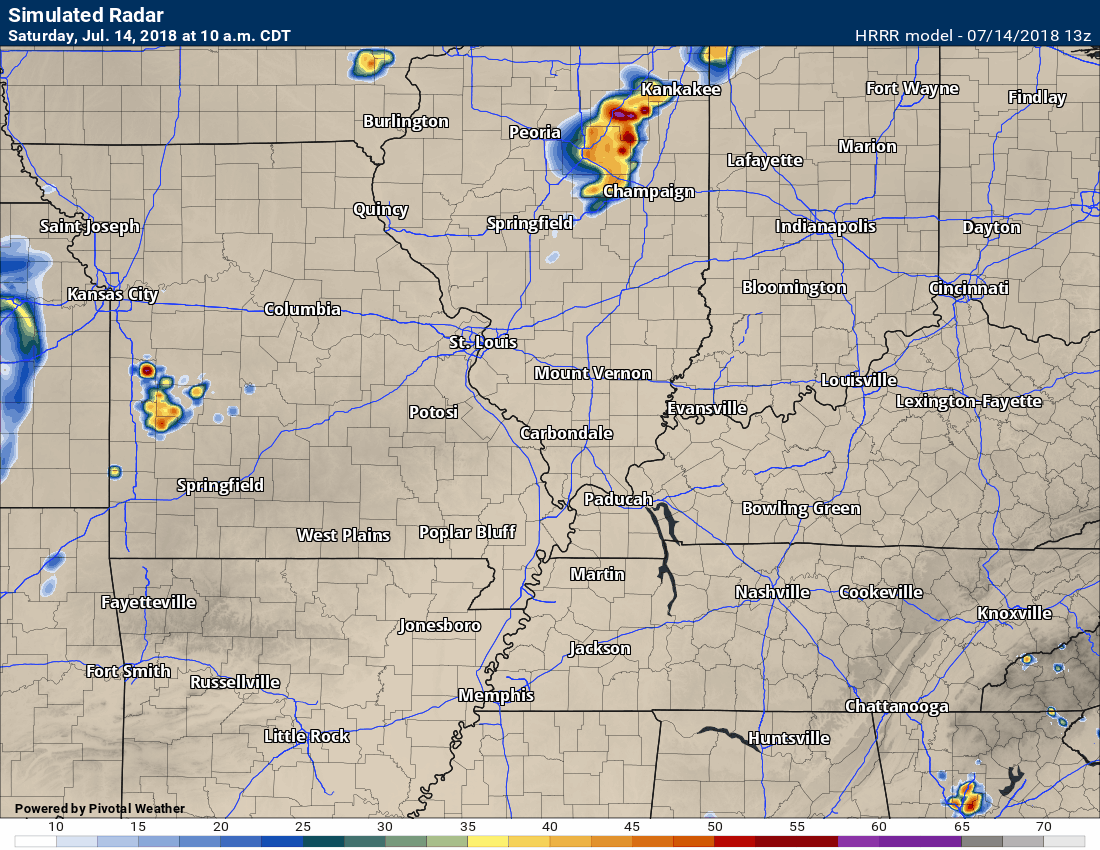
We will see cumulus clouds developing today, as well. Some of those cumulus clouds will tower into thunderstorms. A few spots could pick up an inch or more of rain. Strong winds will occur near thunderstorms, as well. A few locations could experience winds above 40 mph.
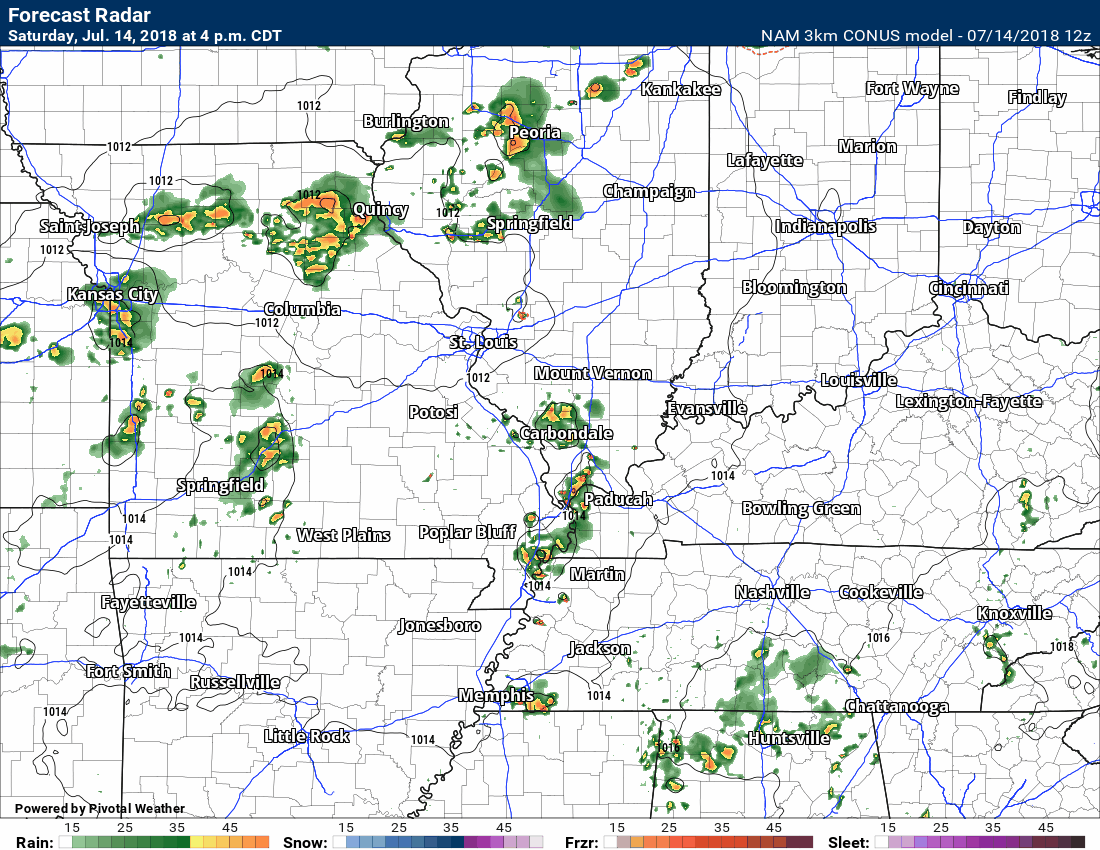
Here is the Hrrr model future-cast radar.
Keep in mind, this is just a model and it won’t be exact. Take away from it the idea that storms will occur today.
Time-stamp upper left.
Shower and thunderstorm chances will increase later tonight into Monday. This will be in response to an incoming cold front.
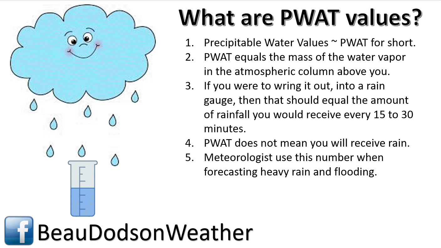
The front will have plenty of moisture to work with. PWAT (a measure of moisture in the atmosphere) values will range from 1.8″ to 2.4″. These are very high numbers. As a matter of fact, some of the guidance shows near record PWAT values.
What does all of that mean? It means that thunderstorms will have no shortage of moisture to tap into. Slow moving thunderstorms cold produce an inch of rain in less than 15 minutes.
This could cause brief flash flooding in a few locations.
If thunderstorms were to train repeatedly over the same areas then the risk of brief flash flooding would increase.
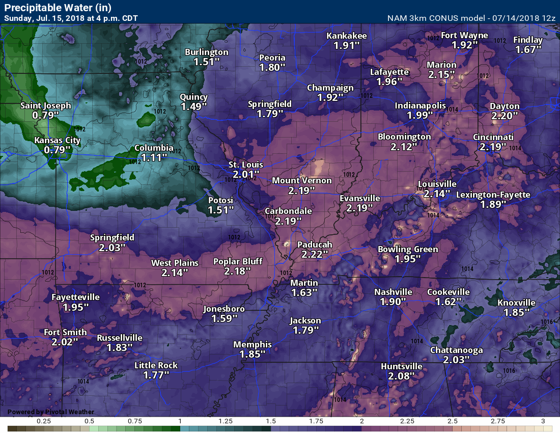
Here is the NAM 3K model guidance PWAT value forecast.
4 PM Sunday numbers. These are large numbers for PWAT values.
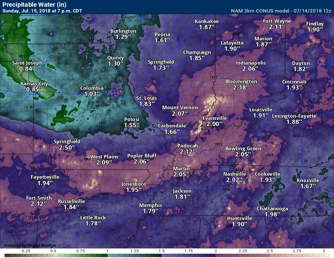
Sunday 7 PM
Again, big moisture values. That could mean locally heavy rain.
The overall severe weather threat is minimal. I can’t rule out isolated severe thunderstorm warnings. The main concern would be heavy rain, frequent lightning, dime size hail, and wind gusts above 50 mph in isolated locations.
Often times these summer thunderstorms do produce pockets of wind damage. The thunderstorm tops can tower to 50 or 60,000 feet. What goes up must come down. All of that energy/force collapses and then produces pockets of damaging wind.
Overall, the severe weather threat at any given location is fairly small.
The thunderstorm chances will peak Sunday afternoon into Monday morning. They will then begin to decrease as we move through Monday afternoon and night.
Here is the latest NAM 3K future-cast radar. This is what it believes radar will look like over the coming days.
Keep in mind, this is just a model. It won’t be exact. Take away the general idea that some storms are likely in the region as a cold front pushes in from the west and north.
Time-stamp upper left.
The latest guidance has sped the cold front up just a bit. That could mean rain chances shut down faster Monday.
Much of the region should remain dry late Monday night into Wednesday.
I will keep an eye on Tuesday in case the front is slower in exiting.
I am monitoring another cold front Thursday or Friday of next week.
Heat Safety!

A new weather podcast is now available! Weather Geeks (which you might remember is on The Weather Channel each Sunday)
To learn more visit their website. Click here.
![]()

WeatherBrains Episode 651
Our two guest WeatherBrains tonight will help us all take a stroll down memory lane by looking back at some of the first years of The Weather Channel.
Tonight’s Guest WeatherBrain #1 is a legend in meteorology. He was the first Director of Meteorology at The Weather Channel, Chief Meteorologist at WSI, and was Dr. Dewpoint on the Intellicast website. He is currently Co-Chief Meteorologist at WeatherBell Analytics. We’re happy to have Joe D’Aleo.
Joining us as Guest WeatherBrain #2 is Al Lipson. Al was a Lead Forecaster at The Weather Channel in the early days. Apparently Al was a bit of a wise-cracker.
Other discussions in this weekly podcast include topics like:
- Extremes: 121 at Death Valley, CA, and 34 at Bodie State Park, CA
- Atlantic Basin has become active
- Chris off Carolina coast now a hurricane
- Beryl reached hurricane status but degenerated to an open wave
- Hot in Southwest US
- Drought centered on Four Corners Area
- Astronomy Outlook with Tony Rice
- and more!
No video this week. There is audio.
Link https://weatherbrains.com/
Previous episodes can be viewed by clicking here.
We offer interactive local city live radars and regional radars. If a radar does not update then try another one. If a radar does not appear to be refreshing then hit Ctrl F5. You may also try restarting your browser.
The local city view radars also have clickable warnings.
During the winter months, you can track snow and ice by clicking the winterize button on the local city view interactive radars.
You may email me at beaudodson@usawx.com
Find me on Facebook!

Find me on Twitter!

Did you know that a portion of your monthly subscription helps support local charity projects?
You can learn more about those projects by visiting the Shadow Angel Foundation website and the Beau Dodson News website.

I encourage subscribers to use the app vs regular text messaging. We have found text messaging to be delayed during severe weather. The app typically will receive the messages instantly. I recommend people have three to four methods of receiving their severe weather information.
Remember, my app and text alerts are hand typed and not computer generated. You are being given personal attention during significant weather events.
