For $5 a month you can receive the following. You may choose to receive these via your WeatherTalk app or regular text messaging.
- Severe weather app/text alerts from my keyboard to your app/cell phone. These are hand typed by Beau. During tornado outbreaks, you will receive numerous app/text messages telling you exactly where the tornado is located.
- Daily forecast app/texts from my computer to your app/cell phone.
- Social media links sent directly to your app/cell phone. When I update the blog, videos, or Facebook you will receive the link.
- AWARE emails. These emails keep you well ahead of the storm. They give you several days of lead time before significant weather events.
- Direct access to Beau via text and email. Your very own personal meteorologist. I work for you!
- Missouri and Ohio Valley centered video updates
- Long-range weather videos
- Week one, two, three and four temperature and precipitation outlooks.
- Monthly outlooks.
- Your subscription also will help support several local charities.
Would you like to subscribe? Subscribe at www.beaudodsonweather.com

I encourage subscribers to use the app vs regular text messaging. We have found text messaging to be delayed during severe weather. The app typically will receive the messages instantly. I recommend people have three to four methods of receiving their severe weather information.
Remember, my app and text alerts are hand typed and not computer generated. You are being given my personal attention during significant weather events.

WWW.WEATHERTALK.COM subscribers, here is my day to day schedule for your weather products.


We offer interactive local city live radars and regional radars. If a radar does not update then try another one. If a radar does not appear to be refreshing then hit Ctrl F5. You may also try restarting your browser.

Interactive Radars:
Interactive live weather radar page. Choose the city nearest your location. If one of the city radars won’t load then try a nearby one. Click here.
August 10, 2018
Friday Forecast Details
Forecast: A mix of sun and clouds. Isolated to widely scattered thunderstorms. Warm.
Temperatures: MO ~ 86 to 90 IL ~ 84 to 88 KY ~ 84 to 88 TN ~ 85 to 88
What is the chance of precipitation? MO ~ 20% IL ~ 20% KY ~ 30% TN ~ 20%
Coverage of precipitation: Isolated to widely scattered
Wind: Light and variable winds.
What impacts are anticipated from the weather? A few wet roadways and lightning. Gusty wind near thunderstorms
My confidence in the forecast verifying: High
Is severe weather expected? Summer storms can produce isolated high winds
The NWS defines severe weather as 58 mph wind or great, 1″ hail or larger, and/or tornadoes
Should I cancel my outdoor plans? No, but glance at radar
UV Index: 8 to 10 High
Sunrise: 6:07 AM
Friday Night Forecast Details:
Forecast: Partly cloudy. An isolated thunderstorm possible (mainly early)
Temperatures: MO ~ 66 to 70 IL ~ 64 to 68 KY ~ 64 to 68 TN ~ 66 to 72
What is the chance of precipitation? MO ~ 20% except far northern parts of southeast Missouri where the chances will be 30% to 40% IL ~ 20% southern tip and 30% to 40% far north and northwest counties of southern IL (closer to Randolph County towards Mt. Vernon) KY ~ 20% to 30% TN ~ 20%
Coverage of precipitation: Isolated to widely scattered
Wind: Northeast and east at 6 to 12 mph
What impacts are anticipated from the weather? Wet roadways and lightning. Gusty wind near thunderstorms
My confidence in the forecast verifying: High
Is severe weather expected? Summer storms can occasionally produce isolated high winds
The NWS defines severe weather as 58 mph wind or great, 1″ hail or larger, and/or tornadoes
Should I cancel my outdoor plans? No, but glance at radars
Sunset: 7:52 PM
Moonrise: 5:02 AM Waning crescent
Moonset: 7:33 PM
August 11, 2018
Saturday Forecast Details
Forecast: Partly to mostly sunny. Some cumulus clouds. Warm. Isolated to widely scattered thunderstorms are possible.
Temperatures: MO ~ 86 to 90 IL ~ 86 to 90 KY ~ 86 to 90 TN ~ 86 to 90
What is the chance of precipitation? MO ~ 30% IL ~ 30% KY ~ 30% TN ~ 30%
Coverage of precipitation: Isolated to widely scattered
Wind: West and northwest at 3 to 6 mph
What impacts are anticipated from the weather? Wet roadways and lightning. Gusty wind near thunderstorms
My confidence in the forecast verifying: High
Is severe weather expected? Summer storms can occasionally produce isolated high winds
The NWS defines severe weather as 58 mph wind or great, 1″ hail or larger, and/or tornadoes
Should I cancel my outdoor plans? No, but glance at radars
UV Index: 8 to 10 High
Sunrise: 6:08 AM
Saturday Night Forecast Details:
Forecast: Partly cloudy. Isolated to widely scattered thunderstorms.
Temperatures: MO ~ 64 to 68 IL ~64 to 68 KY ~ 64 to 68 TN ~ 64 to 68
What is the chance of precipitation? MO ~ 20% to 30% IL ~ 20% KY ~ 20% to 30% TN ~ 30%
Coverage of precipitation: Isolated to widely scattered
Wind: Light winds
What impacts are anticipated from the weather? Scattered wet roadways and lightning. Gusty wind near thunderstorms
My confidence in the forecast verifying: High
Is severe weather expected? Summer storms can occasionally produce isolated high winds
The NWS defines severe weather as 58 mph wind or great, 1″ hail or larger, and/or tornadoes
Should I cancel my outdoor plans? No, but glance at radars
Sunset: 7:51 PM
Moonrise: 6:14 AM New Moon
Moonset: 8:21 PM
August 12, 2018
Sunday Forecast Details
Forecast: Partly sunny. Some cumulus clouds. Warm. Widely scattered thunderstorms possible.
Temperatures: MO ~ 85 to 90 IL ~ 85 to 90 KY ~ 85 to 90 TN ~ 85 to 90
What is the chance of precipitation? MO ~ 20% IL ~ 20% KY ~ 20% TN ~ 20%
Coverage of precipitation: Isolated
Wind: East and northeast at 4 to 8 mph
What impacts are anticipated from the weather? Perhaps some wet roadways. Lightning. Gusty wind near thunderstorms.
My confidence in the forecast verifying: HIgh
Is severe weather expected? Summer storms can occasionally produce isolated high winds
The NWS defines severe weather as 58 mph wind or great, 1″ hail or larger, and/or tornadoes
Should I cancel my outdoor plans? No, but check radars
UV Index: 8 to 10 High
Sunrise: 6:09 AM
Sunday Night Forecast Details:
Forecast: Mostly clear and warm. An isolated evening thunderstorm is possible.
Temperatures: MO ~ 66 to 70 IL ~66 to 70 KY ~ 66 to 70 TN ~ 66 to 70
What is the chance of precipitation? MO ~ 10% IL ~ 10% KY ~ 10% TN ~ 10%
Coverage of precipitation: Isolated
Wind: Light east and southeast winds
What impacts are anticipated from the weather? Isolated wet roads. Lightning.
My confidence in the forecast verifying: High
Is severe weather expected? Summer storms can occasionally produce isolated high winds
The NWS defines severe weather as 58 mph wind or great, 1″ hail or larger, and/or tornadoes
Should I cancel my outdoor plans? No, but check radars
Sunset: 7:50 PM
Moonrise: 7:27 AM New Moon
Moonset: 9:02 PM
I will add the week ahead later today.
We will have shower and thunderstorm chances into the week.
I am monitoring Tuesday and then again late Wednesday into Thursday for some heavy downpours.
Learn more about the UV index readings. Click here.

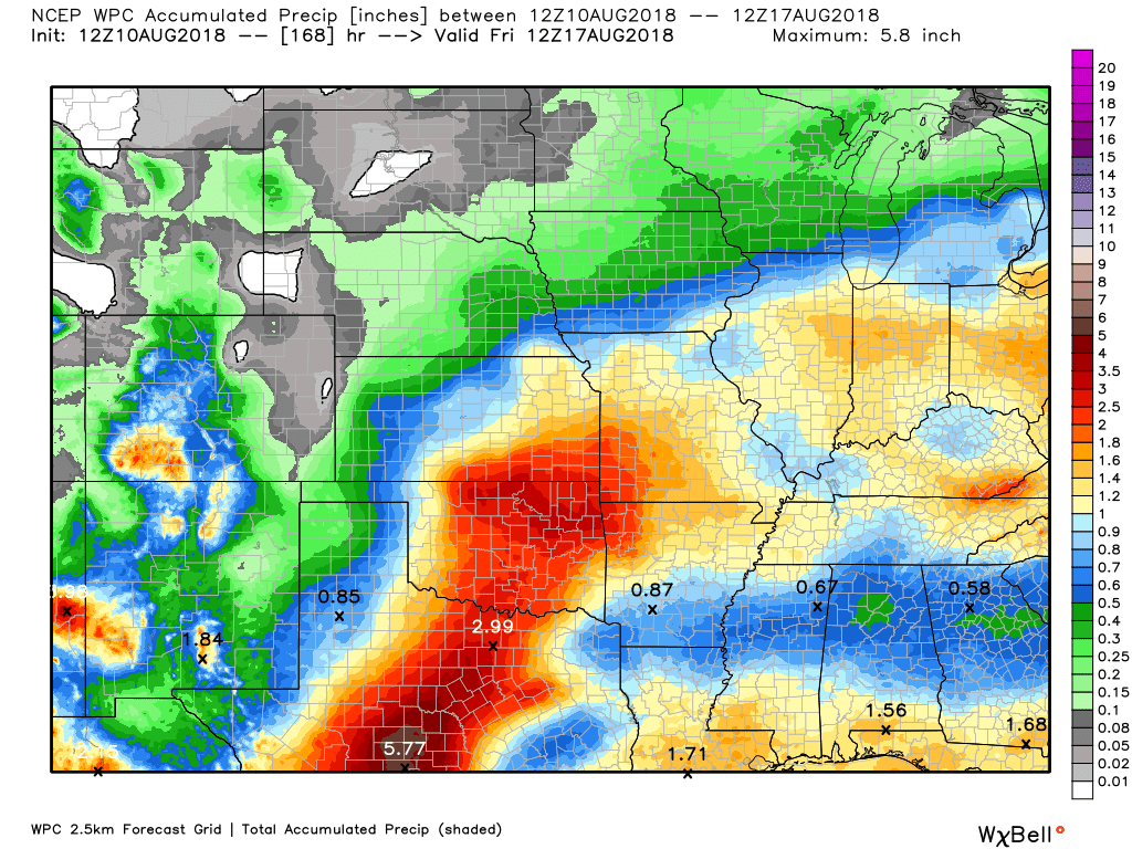
Here is the latest WPC / NOAA Rainfall charts
Here are the 72 hour projected rainfall totals (again, keep the above in mind)

Here is the seven day rainfall forecast from the WPC/NOAA
Click images to enlarge

We offer interactive local city live radars and regional radars.
If a radar does not update then try another one.If a radar does not appear to be refreshing then hit Ctrl F5 on your keyboard.
You may also try restarting your browser.The local city view radars also have clickable warnings.
During the winter months, you can track snow and ice by clicking the winterize button on the local city view interactive radars.

Questions? Broken links? Other questions?
You may email me at beaudodson@usawx.com

The National Weather Service defines a severe thunderstorm as one that produces quarter size hail or larger, 58 mph winds or greater, and/or a tornado.
Friday through Sunday: There will be a few thunderstorms from time to time. The activity will be isolated to widely scattered. Thunderstorms could produce heavy rain and gusty winds. Lightning will be a concern for outdoor activities. The risk of severe weather is low.
Monitor updates concerning the Wednesday/Thursday cold front. Perhaps an increase in thunderstorm activity with the front.
Summer thunderstorms can produce isolated microbursts.
microburst winds can exceed 50 mph.
What are microbursts?

Interactive live weather radar page. Choose the city nearest your location. If one of the cities does not work then try a nearby one. Click here.
National map of weather watches and warnings. Click here.
Storm Prediction Center. Click here.
Weather Prediction Center. Click here.

Live lightning data: Click here.

Interactive GOES R satellite. Track clouds. Click here.

Here are the latest local river stage forecast numbers Click Here.
Here are the latest lake stage forecast numbers for Kentucky Lake and Lake Barkley Click Here.


Weather Headlines
- Missed yesterday’s blog post (travel day and was a bit under the weather)
- Warm weather into next week
- A splattering of summer thunderstorms over the coming days
- Some areas will miss out on the rain and others will pick up a downpour
- A cold front moves through the region Wednesday/Thursday (strong storms possible if that occurs)
- The preliminary September, October, and November outlooks have been posted below.
We have some warm days ahead of us. Extreme heat is not in the forecast. That is the good news. It is August and we all know what that means. It means meteorological fall is only a few weeks away. Meteorologists consider September through November to be fall.
It will be somewhat humid over the coming days. The oppressive heat and humidity, however, is not in the short range forecast.
We will have isolated to widely scattered showers and thunderstorms today into the weekend. Where thunderstorms occur, they could produce locally heavy downpours. Anyone who has lived in the region knows how this song and dance goes.
Your neighbor can pick up an inch or two of rain and those down the road barely receive a drop.
The greatest coverage of shower and thunderstorm activity will be during the afternoon hours. This is when the atmosphere is most unstable. The warm and moist air rises and forms cumulus clouds. Those are the puffy clouds you see billowing upward.
Some of these cumulus clouds turn into cumulonimbus clouds. That means thunderstorms.
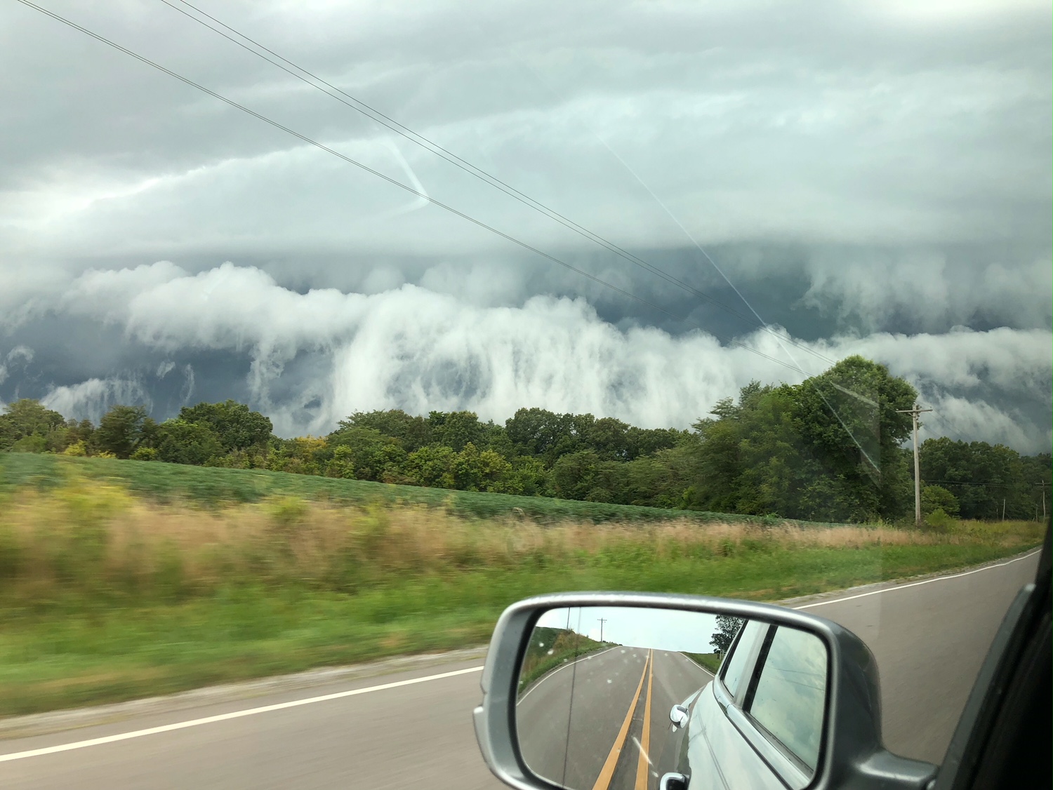
These storms can produce some rather dramatic clouds. Shelf clouds and roll clouds. Many of you witnessed that earlier in the week.
Here is a photo sent in from Donna Smith. Check out this spectacular shelf and roll cloud. This was in southern Illinois. Many of you witnessed this. More bark than bite. It was associated with some gusty wind and rain.
This forms when cool air moves outward from a thunderstorm. The cooler air (caused by rain and downdrafts) then pushes against the warm and moist air at the surface. The end result are shelf and roll clouds!
It almost looks like an ocean wave.
High temperatures over the coming days will mostly be in the middle to upper 80’s. There will be the occasional 90 degree reading. Portions of southeast Missouri may reach into the lower 90’s this afternoon. That would mainly be west of my forecast counties.
There will be a mixture of sun and clouds. All in all, not to bad of a forecast. It could certainly be worse.
Many of you received decent rain Thursday morning and afternoon. A band of thunderstorms pushed northward out of Arkansas and Tennessee.
Jacob Woods, in Graves County, Illinois, reported 1.55″ of much needed rainfall. Jason Darnall, in Benton, Kentucky, received 2.18″ of rain. I received little in the way of rainfall in Massac County. As always, during the summer months, totals varied greatly.
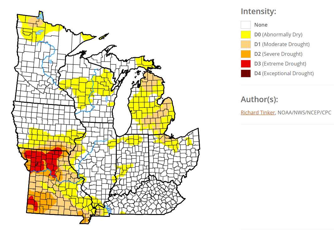
The latest drought monitor does show drought across portions of the region.
Click to enlarge graphics
Here is the southern view
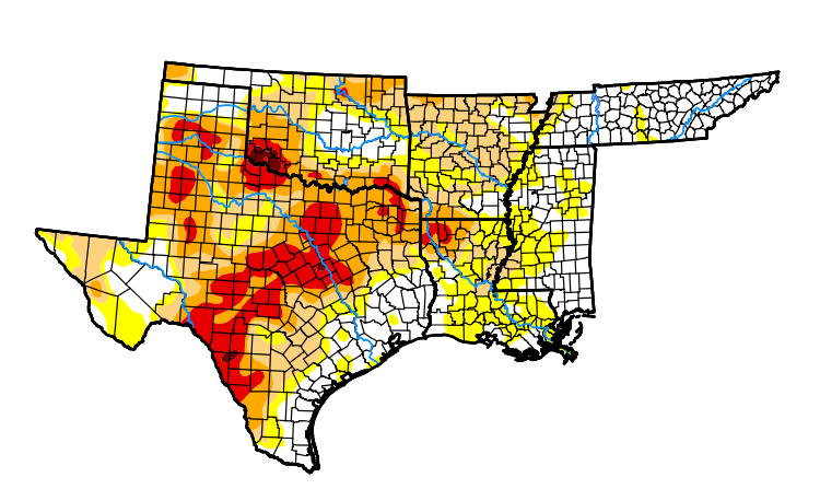
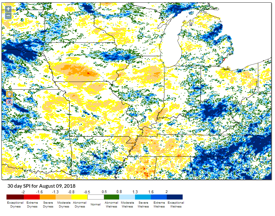
The latest SPI index (a better measure of short term drought conditions) shows dry conditions in our region, as well. This is the 30 day SPI index.
Yesterday’s rainfall was certainly a blessing for many.
You can see a mixture of yellow and blue in our region.
The yellow to orange(ish) colors would be the driest zones. Blue and green would be a bit more moisture in the ground vs other areas.
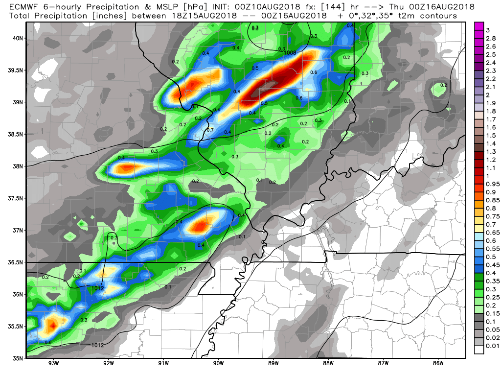
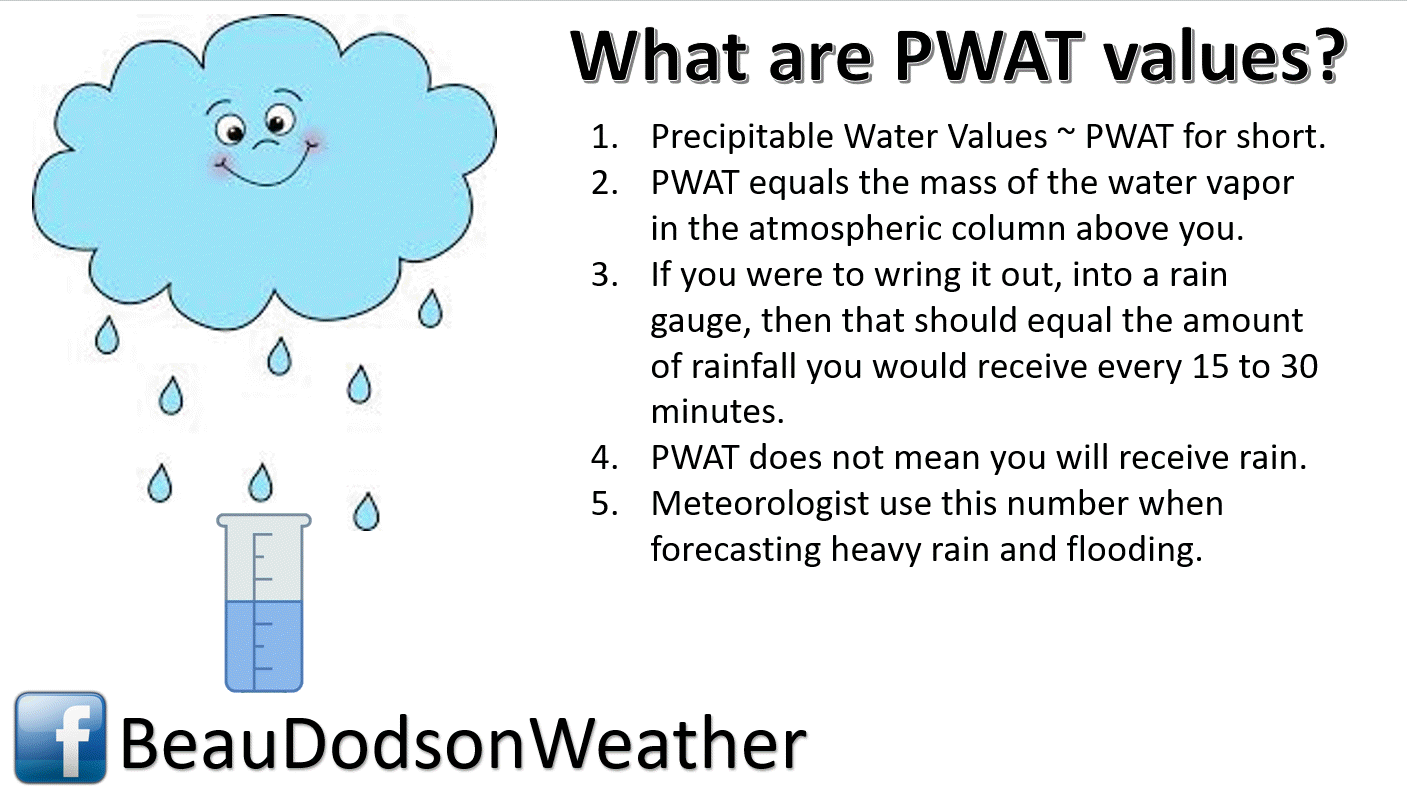
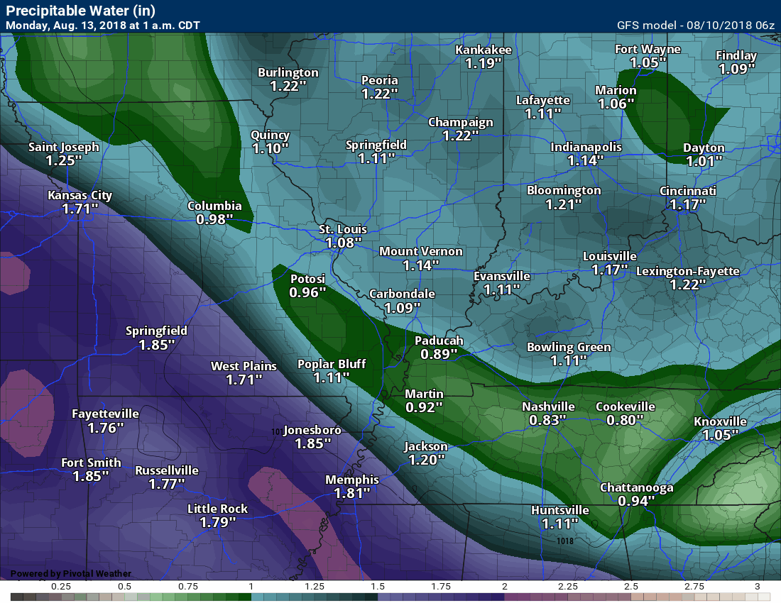
A frontal system Wednesday and Thursday could mean an increase in thunderstorm coverage. I will need to monitor that front. PWAT values (measure of moisture in the atmosphere) will be quite high. That could mean locally heavy downpours.
That is reflected in the WPC rainfall forecast map that I posed at the top of this update.
Here is the EC model guidance for that event.
This image shows you six hour rain totals between 1 PM and 7 PM Wednesday
This next image is 7 PM to 1 AM Wednesday into Thursday
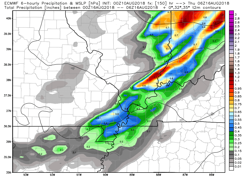
Lastly, this image is 1 AM to 7 AM Thursday

Hopefully, we will receive some additional rain. Many of us need it.
PWAT values will be high Tuesday into the end of the week.
PWAT is a measure of moisture in the atmosphere. These are high numbers. That means that thunderstorms can tap into that and produce torrential downpours (some of you experienced that during this past week).
Time stamp is located in the upper left portion of the animation.
Enjoy your weekend!
EQ = Equal chances of above or below normal
BN= Below normal
M/BN = Much below normal
AN = Above normal
M/AN = Much above normal
This graphic is for subscribers
Outlook definitions
EQ = Equal chances of above or below normal
BN= Below normal
M/BN = Much below normal
AN = Above normal
M/AN = Much above normal
E/AN = Extremely above normal.
..
![]() .
.
.
Outlook definitions
EQ = Equal chances of above or below normal
BN= Below normal
M/BN = Much below normal
AN = Above normal
M/AN = Much above normal
This graphic is for subscribers
Outlook definitions
EQ = Equal chances of above or below normal
BN= Below normal
M/BN = Much below normal
AN = Above normal
M/AN = Much above normal
E/AN = Extremely above normal.
These are bonus videos and maps for subscribers.I bring these to you from the BAMwx team. I pay them to help with videos.
EQ = Equal chances of above or below normal
BN= Below normal
M/BN = Much below normal
AN = Above normal
M/AN = Much above normal
E/AN = Extremely above normal.

These videos are for subscribers.
Subscribe at www.weathertalk.com

These videos are for subscribers.
Subscribe at www.weathertalk.com

These videos are for subscribers.
Subscribe at www.weathertalk.com

I bring these to you from the BAMwx team. They are excellent long-range forecasters.
Remember, long-range outlooks are a bit of skill, understanding weather patterns, and luck combined. It is not an exact science.

Normal high temperatures for this time of the year are around 92 degrees.
Normal low temperatures for this time of the year are around 69 degrees.
Normal precipitation during this time period ranges from 0.25″ to 0.50″
This outlook covers August 6th through August 12th
These graphics are for subscribers.
Subscribe at www.weathertalk.com
The precipitation forecast is PERCENT OF NORMAL. For example, if your normal rainfall is 1.00″ and the graphic shows 10%, then that would mean 0.10″ of rain is anticipated.
Always keep in mind, slow moving summer thunderstorms can produce torrential rain. That could skew the rainfall outlook.
These graphics are for subscribers.
Subscribe at www.weathertalk.com

These graphics are for subscribers.
The precipitation forecast is PERCENT OF NORMAL. For example, if your normal rainfall is 1.00″ and the graphic shows 10%, then that would mean 0.10″ of rain is anticipated.
These graphics are for subscribers.
Subscribe at www.weathertalk.com

These graphics are for subscribers.
Subscribe at www.weathertalk.com
And precipitation
These graphics are for subscribers.
Subscribe at www.weathertalk.com
Temperature outlook for June through August.
These graphics are for subscribers.
Subscribe at www.weathertalk.com
July temperature and precipitation outlook
These graphics are for subscribers.
Subscribe at www.weathertalk.com
August temperature and precipitation outlook
These graphics are for subscribers.
Subscribe at www.weathertalk.com
![]()

A new weather podcast is now available! Weather Geeks (which you might remember is on The Weather Channel each Sunday)
To learn more visit their website. Click here.
![]()

WeatherBrains Episode 652
Tonight’s Guest WeatherBrain is a weather legend, having spanned four decades as a broadcast meteorologist. He is a Fellow of the AMS. Joe Witte, welcome to WeatherBrains!
Other discussions in this weekly podcast include topics like:
- Athletes who are passionate about weather
- What all is involved with TV weather internships
- NASA’s intern program
- KATV’s Ned Perme retiring after 34 years
- Astronomy Outlook with Tony Rice
- Drake University sportscaster Larry Cotlar dies in Iowa flash flooding
- and more!
Link to web-site https://weatherbrains.com/
Previous episodes can be viewed by clicking here.
We offer interactive local city live radars and regional radars. If a radar does not update then try another one. If a radar does not appear to be refreshing then hit Ctrl F5. You may also try restarting your browser.
The local city view radars also have clickable warnings.
During the winter months, you can track snow and ice by clicking the winterize button on the local city view interactive radars.
You may email me at beaudodson@usawx.com
Find me on Facebook!

Find me on Twitter!

Did you know that a portion of your monthly subscription helps support local charity projects?
You can learn more about those projects by visiting the Shadow Angel Foundation website and the Beau Dodson News website.

I encourage subscribers to use the app vs regular text messaging. We have found text messaging to be delayed during severe weather. The app typically will receive the messages instantly. I recommend people have three to four methods of receiving their severe weather information.
Remember, my app and text alerts are hand typed and not computer generated. You are being given personal attention during significant weather events.
