2018 Teddy Bear Fund Raiser Campaign!
The Shadow Angel Foundation is raising money for new teddy bears to be donated to Child Watch and PASAC of western Kentucky. This is our 15th year of donating new bears to these two organizations.
This is a matching fundraiser. That means your donation is doubled.
If you would like to help then follow this link

Daily WeatherTalk schedule
Click schedule for a larger view. Keep in mind, during active weather this schedule will change. There will be additional updates outside of what has been posted here.


We offer interactive local city live radars and regional radars. If a radar does not update then try another one. If a radar does not appear to be refreshing then hit Ctrl F5. You may also try restarting your browser.

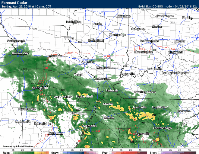
April 22, 2018
Sunday Forecast Details
Forecast: Cloudy. Widespread rain. An isolated thunderstorm possible. Northern counties will have less rain coverage than the rest of the area.
Temperatures: MO ~ 56 to 62 IL ~ 56 to 62 KY ~ 56 to 62 TN ~ 58 to 62
What is the chance of precipitation? MO ~ 90% (Bootheel) 60% northern counties of southeast Missouri IL ~ 70% KY ~ 100% TN ~ 100%
Coverage of precipitation: Numerous for most areas. Far northern counties will be more scattered vs south.
Winds: East at 5 to 10 mph with gusts to 15 mph. Winds will be quite gusty around the low. Winds near the low will be nearly calm.
What impacts are anticipated from the weather? Wet roadways. Isolated lightning.
My confidence in the forecast verifying: High
Is severe weather expected? No
The NWS defines severe weather as 58 mph wind or great, 1″ hail or larger, and/or tornadoes
Should I cancel my outdoor plans? Have a plan B.
Sunrise: 6:10 AM
Sunday Night Forecast Details:
Forecast: Cloudy. Cool. Rain likely. An isolated thunderstorm possible.
Temperatures: MO ~ 45 to 50 IL ~ 45 to 50 KY ~ 45 to 50 TN ~ 46 to 52
What is the chance of precipitation? MO ~ 70% IL ~ 80% KY ~ 100% TN ~ 100%
Coverage of precipitation: Numerous.
Winds: Variable wind direction at 8 to 16 mph and gusty. Winds will be quite gusty around the low. Winds near the low will be nearly calm.
What impacts are anticipated from the weather? Wet roadways. Isolated lightning.
My confidence in the forecast verifying: High
Is severe weather expected? No
The NWS defines severe weather as 58 mph wind or great, 1″ hail or larger, and/or tornadoes
Should I cancel my outdoor plans? Have a plan B.
Sunset: 7:35 PM
April 23, 2018
Monday Forecast Details
Forecast: If the dry slot moves into our region then the sun could come out. If that happens then a few storms will be possible, as well. Small hail could occur with any storms that form. Mostly cloudy. Rain showers likely. Isolated thunderstorm possible.
Temperatures: MO ~ 58 to 64 IL ~ 60 to 65 KY ~ 62 to 66 TN ~ 62 to 66
What is the chance of precipitation? MO ~ 60% IL ~ 60% KY ~ 60% TN ~ 60%
Coverage of precipitation: Scattered to perhaps numerous.
Winds: Variable wind direction at 7 to 14 mph with gusty winds from time to time. Winds will be quite gusty around the low. Winds near the low will be nearly calm.
What impacts are anticipated from the weather? Wet roadways. Isolated lightning. Small hail.
My confidence in the forecast verifying: High
Is severe weather expected? No
The NWS defines severe weather as 58 mph wind or great, 1″ hail or larger, and/or tornadoes
Should I cancel my outdoor plans? No, but monitor updates.
Sunrise: 6:09 AM
Monday Night Forecast Details:
Forecast: Cloudy. Scattered showers possible. Cool.
Temperatures: MO ~ 46 to 52 IL ~ 46 to 52 KY ~ 46 to 52 TN ~ 46 to 52
What is the chance of precipitation? MO ~ 30% IL ~ 30% KY ~ 40% TN ~ 40%
Coverage of precipitation: Scattered
Winds: Variable at 7 to 14 mph
What impacts are anticipated from the weather? Wet roadways
My confidence in the forecast verifying: Medium
Is severe weather expected? No
The NWS defines severe weather as 58 mph wind or great, 1″ hail or larger, and/or tornadoes
Should I cancel my outdoor plans? No, but monitor updates.
Sunset: 7:36 PM
April 24, 2018
Tuesday Forecast Details
Forecast: Quite a few clouds. A few showers possible, esp over Kentucky and Tennessee.
Temperatures: MO ~ 63 to 66 IL ~ 63 to 66 KY ~ 63 to 66 TN ~ 63 to 66
What is the chance of precipitation? MO ~ 20% IL ~ 20% KY ~ 30% TN ~ 30%
Coverage of precipitation: Isolated to scattered
Winds:North and northwest at 5 to 10 mph with gusts to 14 mph
What impacts are anticipated from the weather? A few wet roadways.
My confidence in the forecast verifying: Medium
Is severe weather expected? No
The NWS defines severe weather as 58 mph wind or great, 1″ hail or larger, and/or tornadoes
Should I cancel my outdoor plans? No
Sunrise: 6:08 AM
Tuesday Night Forecast Details:
Forecast: Partly cloudy. An isolated shower possible.
Temperatures: MO ~ 43 to 46 IL ~ 43 to 46 KY ~ 45 to 50 TN ~ 45 to 50
What is the chance of precipitation? MO ~ 20% IL ~ 20% KY ~ 20% TN ~ 20%
Coverage of precipitation: Scattered
Winds: North at 5 to 10 mph
What impacts are anticipated from the weather? Wet roadways
My confidence in the forecast verifying: Medium
Is severe weather expected? No
The NWS defines severe weather as 58 mph wind or great, 1″ hail or larger, and/or tornadoes
Should I cancel my outdoor plans? No
Sunset: 7:37 PM
April 25, 2018
Wednesday Forecast Details
Forecast: Partly cloudy. Mild. A chance of a shower.
Temperatures: MO ~ 65 to 68 IL ~ 65 to 68 KY ~ 65 to 68 TN ~ 65 to 68
What is the chance of precipitation? MO ~ 20% IL ~ 20% KY ~ 20% TN ~ 20%
Coverage of precipitation: Isolated
Winds: Northwest at 5 to 10 mph
What impacts are anticipated from the weather? Perhaps wet roadways
My confidence in the forecast verifying: Medium
Is severe weather expected? No
The NWS defines severe weather as 58 mph wind or great, 1″ hail or larger, and/or tornadoes
Should I cancel my outdoor plans? No
Sunrise: 6:07 AM
Wednesday Night Forecast Details:
Forecast: Partly cloudy. Cool.
Temperatures: MO ~ 42 to 46 IL ~ 42 to 46 KY ~ 43 to 46 TN ~ 44 to 48
What is the chance of precipitation? MO ~ 0% IL ~ 0% KY ~ 0% TN ~ 0%
Coverage of precipitation: None
Winds: Northwest to northwest at 5 to 10 mph
What impacts are anticipated from the weather? None
My confidence in the forecast verifying: Medium
Is severe weather expected? No
The NWS defines severe weather as 58 mph wind or great, 1″ hail or larger, and/or tornadoes
Should I cancel my outdoor plans? No
Sunset: 7:38 PM
April 26, 2018
Thursday Forecast Details
Forecast: Partly sunny.
Temperatures: MO ~ 65 to 70 IL ~ 65 to 68 KY ~ 65 to 70 TN ~ 65 to 70
What is the chance of precipitation? MO ~ 10% IL ~ 10% KY ~ 10% TN ~ 10%
Coverage of precipitation: Most likely none.
Winds: South and southwest at 6 to 12 mph with gusts to 18 mph
What impacts are anticipated from the weather? Most likely none.
My confidence in the forecast verifying: Medium
Is severe weather expected? No
The NWS defines severe weather as 58 mph wind or great, 1″ hail or larger, and/or tornadoes
Should I cancel my outdoor plans? No
Sunrise: 6:05 AM
Thursday Night Forecast Details:
Forecast: Cloudy. A chance of showers.
Temperatures: MO ~ 44 to 48 IL ~ 44 to 48 KY ~ 46 to 48 TN ~ 48 to 50
What is the chance of precipitation? MO ~ 0% IL ~ 0% KY ~ 0% TN ~ 0%
Coverage of precipitation: Scattered
Winds: Winds becoming west and northwest at 7 to 14 mph
What impacts are anticipated from the weather? Wet roadways. Perhaps lightning.
My confidence in the forecast verifying: Medium
Is severe weather expected? No
The NWS defines severe weather as 58 mph wind or great, 1″ hail or larger, and/or tornadoes
Should I cancel my outdoor plans? No
Sunset: 7:39 PM
April 27, 2018
Friday Forecast Details
Forecast: Partly cloudy. A slight chance of a morning shower.
Temperatures: MO ~ 63 to 66 IL ~ 63 to 66 KY ~ 63 to 66 TN ~ 63 to 66
What is the chance of precipitation? MO ~ 20% IL ~ 30% KY ~ 30% TN ~ 20%
Coverage of precipitation: Isolated to scattered early
Winds: Northwest 7 to 14 mph
What impacts are anticipated from the weather? Wet roadways
My confidence in the forecast verifying: Medium
Is severe weather expected? No
The NWS defines severe weather as 58 mph wind or great, 1″ hail or larger, and/or tornadoes
Should I cancel my outdoor plans? No
Sunrise: 6:04 AM
Friday Night Forecast Details:
Forecast: Partly cloudy. Cool.
Temperatures: MO ~ 40 to 45 IL ~ 40 to 45 KY ~ 40 to 45 TN ~ 40 to 45
What is the chance of precipitation? MO ~ 0% IL ~ 0% KY ~ 0% TN ~ 0%
Coverage of precipitation: None
Winds: Northwest at 5 to 10 mph with gusts to 14
What impacts are anticipated from the weather? None
My confidence in the forecast verifying: Medium
Is severe weather expected? No
The NWS defines severe weather as 58 mph wind or great, 1″ hail or larger, and/or tornadoes
Should I cancel my outdoor plans? No
Sunset: 7:40 PM
April 28, 2018
Saturday Forecast Details
Forecast: Mostly sunny.
Temperatures: MO ~ 60 to 65 IL ~ 63 to 66 KY ~ 63 to 66 TN ~ 64 to 68
What is the chance of precipitation? MO ~ 0% IL ~ 0% KY ~ 0% TN ~ 0%
Coverage of precipitation: None
Winds: Northwest at 5 to 10 mph
What impacts are anticipated from the weather? None
My confidence in the forecast verifying: Medium
Is severe weather expected? No
The NWS defines severe weather as 58 mph wind or great, 1″ hail or larger, and/or tornadoes
Should I cancel my outdoor plans? No
Sunrise: 6:03 AM
Saturday Night Forecast Details:
Forecast: Mostly clear. Cool.
Temperatures: MO ~ 44 to 48 IL ~ 44 to 48 KY ~ 46 to 48 TN ~ 48 to 50
What is the chance of precipitation? MO ~ 0% IL ~ 0% KY ~ 0% TN ~ 0%
Coverage of precipitation: None
Winds: Variable 4 to 8 mph
What impacts are anticipated from the weather? None
My confidence in the forecast verifying: Medium
Is severe weather expected? No
The NWS defines severe weather as 58 mph wind or great, 1″ hail or larger, and/or tornadoes
Should I cancel my outdoor plans? No
Sunset: 7:40 PM
April 29, 2018
Sunday Forecast Details
Forecast: Mostly sunny. Warmer.
Temperatures: MO ~ 65 to 70 IL ~ 65 to 68 KY ~ 65 to 70 TN ~ 65 to 70
What is the chance of precipitation? MO ~ 0% IL ~ 0% KY ~ 0% TN ~ 0%
Coverage of precipitation: None
Winds: South at 5 to 10 mph
What impacts are anticipated from the weather? None
My confidence in the forecast verifying: Medium
Is severe weather expected? No
The NWS defines severe weather as 58 mph wind or great, 1″ hail or larger, and/or tornadoes
Should I cancel my outdoor plans? No
Sunrise: 6:02 AM
Sunday Night Forecast Details:
Forecast: Partly cloudy.
Temperatures: MO ~ 48 to 54 IL ~ 48 to 54 KY ~ 48 to 54 TN ~ 48 to 54
What is the chance of precipitation? MO ~ 0% IL ~ 0% KY ~ 0% TN ~ 0%
Coverage of precipitation: None
Winds: South at 5 to 10 mph
What impacts are anticipated from the weather? None
My confidence in the forecast verifying: LOW
Is severe weather expected? No
The NWS defines severe weather as 58 mph wind or great, 1″ hail or larger, and/or tornadoes
Should I cancel my outdoor plans? No
Sunset: 7:41 PM
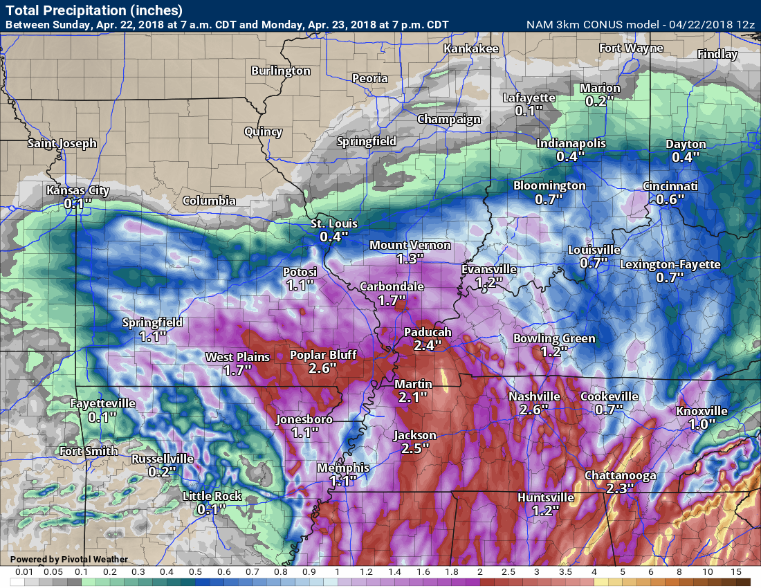
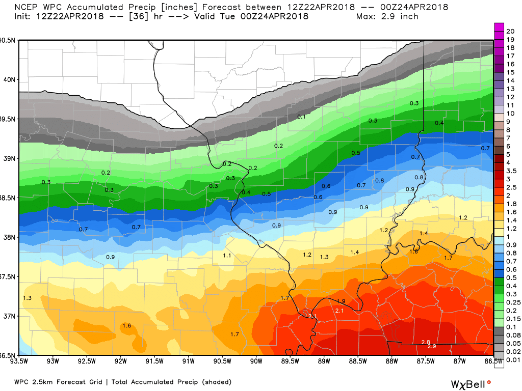
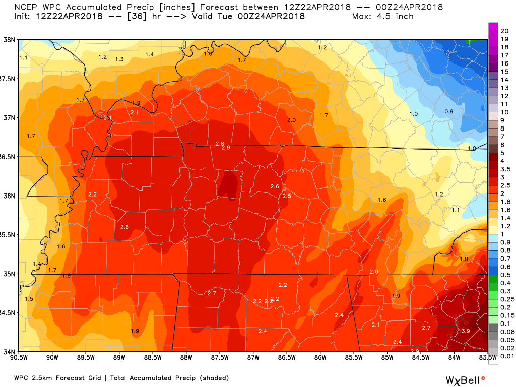
RAIN TOTALS
NAM 3K model rainfall forecast (keep in mind this is a models opinion). Totals will vary.
WPC/NOAA rainfall forecast. Southeast view and northwest view.
Click images to enlarge.
SE view
NW view

Interactive Radars:
Interactive live weather radar page. Choose the city nearest your location. If one of the cities does not work then try a nearby one. Click here.

Questions? Broken links? Other?
You may email me at beaudodson@usawx.com

The National Weather Service defines a severe thunderstorm as one that produces quarter size hail or larger, 58 mph winds or greater, and/or a tornado.
Sunday through Wednesday: Thunderstorms on Monday could produce lightning and small hail. Organized severe weather is not anticipated.
![]()
Interactive live weather radar page. Choose the city nearest your location. If one of the cities does not work then try a nearby one. Click here.
National map of weather watches and warnings. Click here.
Storm Prediction Center. Click here.
Weather Prediction Center. Click here.

Live lightning data: Click here.

Interactive GOES R satellite. Track clouds. Click here.

Here are the latest local river stage forecast numbers Click Here.
Here are the latest lake stage forecast numbers for Kentucky Lake and Lake Barkley Click Here.

The spring and preliminary summer outlooks have been posted for subscribers. Scroll down to see the outlook.
Not a subscriber? Learn more at this link.

Weekend short update.
Future-cast radar from the NAM 3K model guidance. Timestamp upper left.
This is what radar might look like over the next 48 hours (NAM 3K model).
![]()

A new podcast is coming! Weather Geeks (which you might remember is on The Weather Channel each Sunday)
To learn more visit their website. Click here.
![]()

Weather Brains is a weekly podcast/video for those who love weather and want more!
Weather Brains episode number 638
Tonight’s Guest WeatherBrain is the Associate Director at the Extreme Events Institute at Florida International University. Erik Salna, welcome to WeatherBrains!
Other discussions in this weekly podcast include topics like:
- Extremes: 95 at Death Valley, CA, and 9 at Valentine, NE
- Wet weekend over Southeast US
- A chilly start to the week with 30s into Southeast US
- The potential of severe storms Friday into Saturday
- Tornadoes touch down in Carolinas and Virginia
- Astronomy Outlook with Tony Rice
- and more!
Previous episodes can be viewed by clicking here.
We offer interactive local city live radars and regional radars. If a radar does not update then try another one. If a radar does not appear to be refreshing then hit Ctrl F5. You may also try restarting your browser.
The local city view radars also have clickable warnings.
During the winter months, you can track snow and ice by clicking the winterize button on the local city view interactive radars.
You may email me at beaudodson@usawx.com
Find me on Facebook!

Find me on Twitter!

Did you know that a portion of your monthly subscription helps support local charity projects?
You can learn more about those projects by visiting the Shadow Angel Foundation website and the Beau Dodson News website.

I encourage subscribers to use the app vs regular text messaging. We have found text messaging to be delayed during severe weather. The app typically will receive the messages instantly. I recommend people have three to four methods of receiving their severe weather information.
Remember, my app and text alerts are hand typed and not computer generated. You are being given personal attention during significant weather events.
