
January 17, 2015 – Beau Dodson
There are a lot of challenges when forecasting winter storms in our region. Typically we are on the rain/snow line. That means that some of our counties will receive snow. Some of our counties will receive sleet. Some of our counties will receive freezing rain. And, some of our counties will end up rain! Trying to figure out what counties will receive what precipitation is usually problematic.
I want to encourage you to check back frequently for forecast updates leading up to and during a winter storm. The forecast will change. Rarely does a forecast 24-48 hours in advance of the winter storm stay the same. The forecast will evolve. One hopes the forecast becomes more accurate as the event draws nearer. But, with that said, it is not unusual for the forecast to be updated while a storm is underway.
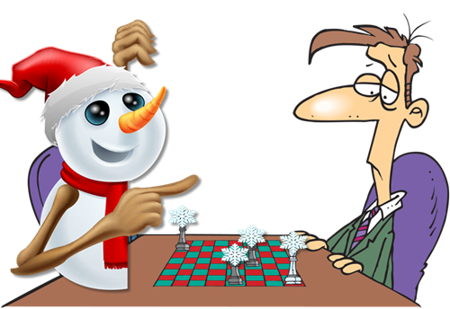
Think of a winter storm as a game of chess. The storm moves…forecasters reevaluate and then make a forecast. The storm makes its next move. Forecasters reevaluate and update the forecast. With each move of the winter storm it becomes more and more clear what direction the forecast should move towards. A great forecaster will stay one step ahead of the winter storm. But, there are always surprises. Checkmate? Sometimes.
Most winter storm will over-perform in a few counties. Most winter storms will under-perform in a few counties. During a rainstorm not everybody ends up with the exact same amount of precipitation. The same applies to winter storms. Nobody cares if they receive 0.30″ vs 0.60″ of rain during the summer months. Most people would not even realize the difference. But, again – when that ends up being snow you are looking at the difference between a 3″ snowstorm and a 6″ snowstorm!

Doesn’t changing the forecast, during a winter storm, mean the meteorologist has no clue as to what they are doing?
No. This is an expectation misconception. Sometimes the public sets their expectations too high. I would ask that you remember that a forecast is a prediction and not a promise. A forecast is predicting something that is going to happen in the future. Even the best forecaster will update and tweak their forecast once a winter storm is underway (sometimes more than once).
The atmosphere is a fluid. And thus, it is fluid! If a storm shifts 30 or 40 miles then that will change the forecast. Thirty or forty miles, in our large expansive atmosphere, is a grain of sand.
If a snowstorm is forecast for Wednesday and you read the forecast on Monday and then you don’t check later updates…well, you are not going to receive an accurate forecast. You might have a general idea of what to expect, but it likely won’t be very accurate.
Most of you want to know what will happen in your backyard. We call this IMBY (in my backyard). What you should remember is that forecasting snow is not the same as forecasting rain.
During the summer months if I forecast 0.10″ of rain, most of you really don’t care. That is not enough rain to disrupt your ballgame or outdoor events. But, did you know that 0.10″ of rain equals about 1″ of snow? In our region, one inch of snow, on cold roadways, can cause widespread hazardous driving conditions. Unfortunately, these light snow events usually cause widespread problems. People perceive the threat as minimal (it wasn’t an 8″ snowstorm so it must not be that bad). The reality is that the threat can be higher during a minimal snow event than a bigger event. Historically that has been the case in our region.
There is a lot of pressure on forecasters to accurately forecast the impacts of a winter weather event. Normally the forecast will change several times before the storm occurs. Normally the forecast changes while a storm is underway. Forecasting impact is not an exact science.
Impacts can depend on
- Road temperatures
- Time of the event (morning rush hour or afternoon)
- Day of the week (weekend system vs a Monday morning “back to work event”
- Ground/surface temperatures
- Wind speed (blowing snow or drifting snow)
- Time of year. Is this the first winter storm of the season?
- All snow event or did it rain before it snowed? Wintry mix or plain snow?
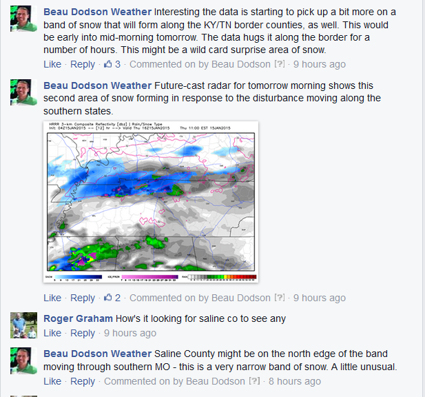
The best advice when following a winter storm forecast is to check back frequently for updates. The winter storm this past Thursday produced a dusting in some of our counties. Many counties ended up with 1/2″-2″ of snow. This caused icy roadways. Forecasters were not sure where the heaviest band would develop until it developed. Some of the high resolution models picked up on the potential for banding as early as late Wednesday night. But, again – the exact placement of banding was questionable.
What is banding? Snow banding is a concentration of falling snow over a three to six hour period in a 20 to 50 mile area. Banding can cause enhanced snowfall totals. Where banding occurs can be extremely difficult to pinpoint even hours in advance…let alone a day in advance.
Banding can mean the difference between a dusting of snow and a few inches of snow. Banding can wreck an otherwise great forecast. Banding is what causes forecasters to bang their heads on the forecast desk.
Mesoscale banding of snowfall is a complicated process that is very difficult to forecast for. It is usually a process that is misunderstood by the general public and can lead to some thinking that meteorologist have no clue what the storm is going to do. The best way to approach the forecasting of such environments is to try to explain the threat and the impact of such processes.
I knew banding would occur on Thursday morning. The question was where would it occur. It ended up occurring over portions of western Kentucky. Where banding occurred there were several reports of 2″ of snow (and some places a bit more).
This was covered in the now-cast thread on my Facebook page and Twitter account. A now-cast is a forecast update as an event unfolds. Again, this is why you should check back for updated forecasts.
Here was a post I made the night before the snow event (Facebook post)
I show you this so that you understand the data flows…continuously. One forecast isn’t going to give you the entire picture. Checking back is the best advice.
Also don’t forget to utilize Twitter. The Paducah, KY National Weather Service has an account…local media meteorologists have accounts. These are two tweets that I sent out during the event.
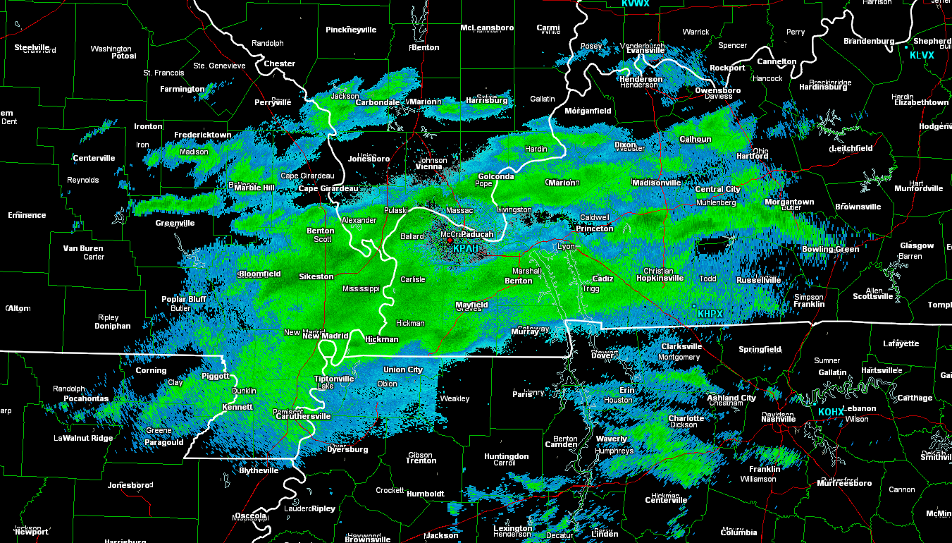
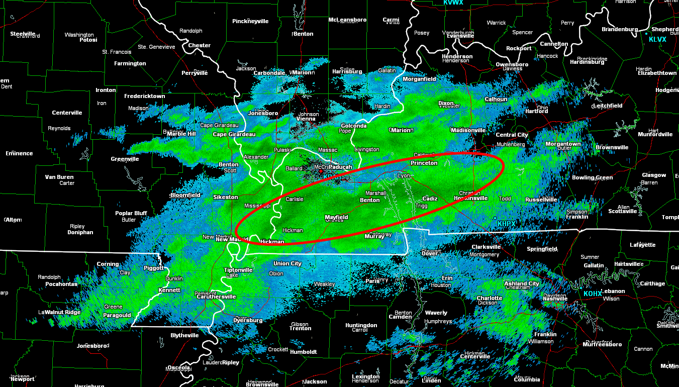
Click images for larger view
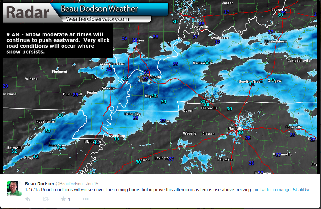
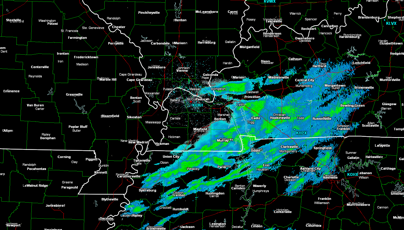
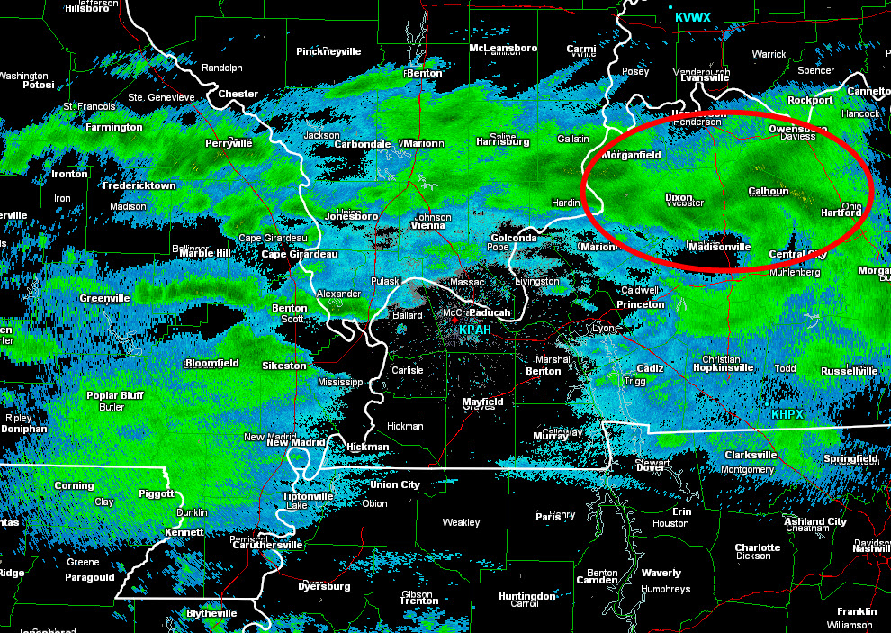
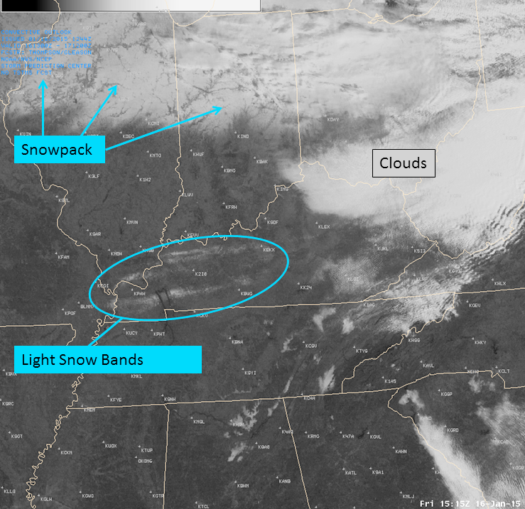
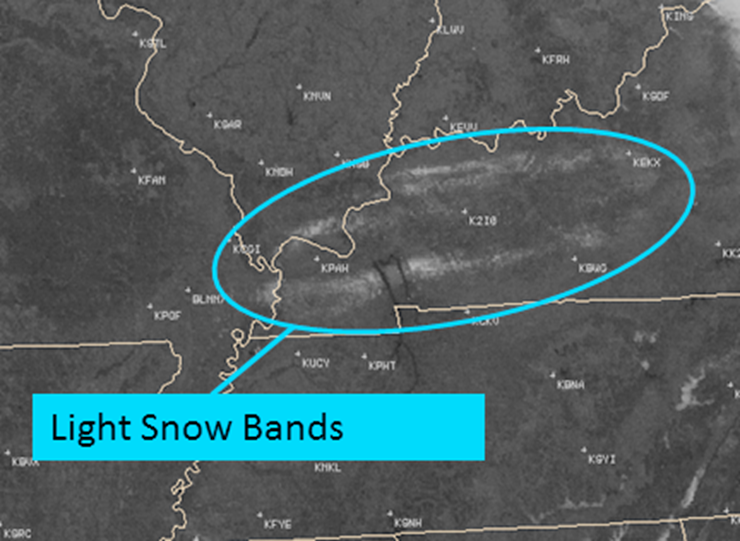
Let’s take a look at radar from this snow event…
I am going to show you were bands of enhanced snowfall occurred.
These images represent a time frame of 3-4 hours.
I circled the area where a heavier snow band formed.
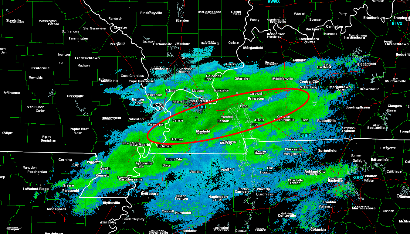
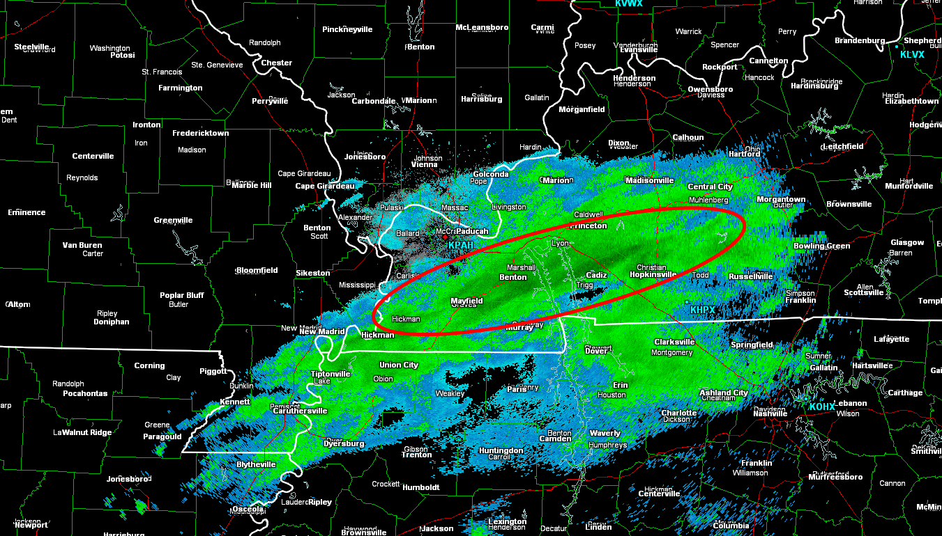
Note this area of moderate snow over parts of the Owensboro, Kentucky area (image below). Numerous wrecks were reported in Daviess County, Kentucky. Some with injuries. At least one fatality was reported.
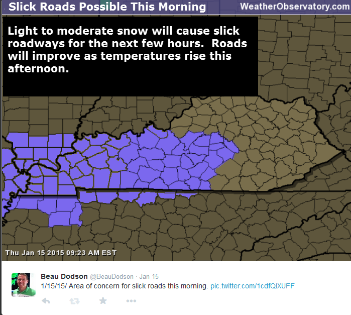
These small bands of moderate snow made it complicated for the National Weather Service. There were questions as to whether they should issue a winter weather advisory or cover it with a special weather statement. Not an easy decision because the problem areas were spotty. In the end, the problem areas were covered with special weather statements, instead of advisories (see the graphic of the SWS below).
Radar animation…
Here is the radar animation from the Paducah, Kentucky National Weather Service. Note the heavier snow that formed near Owensboro, KY. This is one area that reported numerous wrecks. Daviess County, KY.
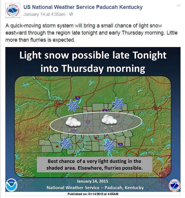
Let’s take a look at the Paducah Kentucky, NWS Facebook page. These are some of the posts leading up to the event…
You can see how the forecast “evolves” over time. As the event was underway they had to update the forecast with now-casts and special weather statements. If you only read the forecast from Wednesday afternoon then you would not have known that snow was also going to impact parts of western Kentucky. This is why you need to keep checking back (even hours before an event or during an event).
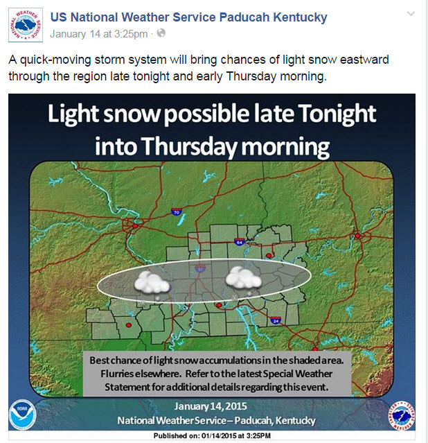
This update was issued at 4:30 AM on Wednesday morning. During this update only flurries (or a light dusting) were forecast. The forecast would later be updated with new information. The new forecast would increase snowfall amounts.
This next update was issued at 3:25 pm on Wednesday afternoon. At this point the NWS was talking about light snow and centered the concern from southeast Missouri into southern Illinois. The models were showing this to be the area of most concern.
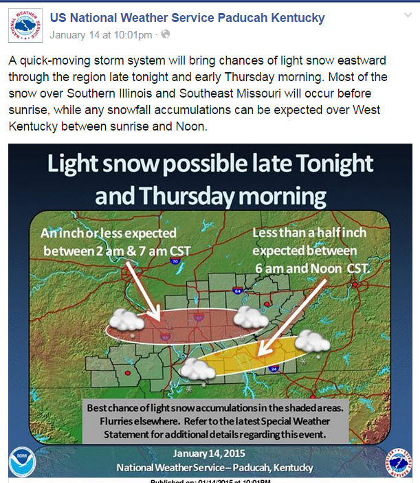
This next update was issued at 10 PM on Wednesday night. The event was only hours away. Snow had already developed over southern Missouri and was spreading eastward into southeast Missouri. At this point it was becoming a now-cast event (now-cast means the event is immediate and the forecast is being issued as the event is underway).
By this point the high resolution models were showing that snow would also develop over western Kentucky. You can see the NWS started to include western Kentucky in their snow forecast (not just MO/IL).
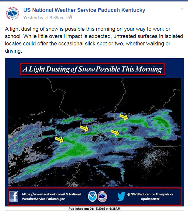
This next update was issued at 6:38 AM. The snow event was underway. Over the coming hours the snow would intensify over parts of southeast Missouri, far southern Illinois, and western Kentucky.
Here is one of the special weather statements that the Paducah, Kentucky National Weather Service issued:
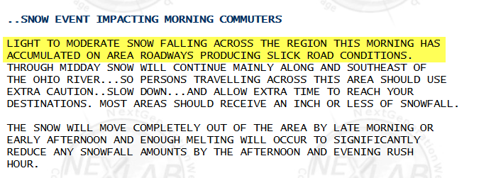
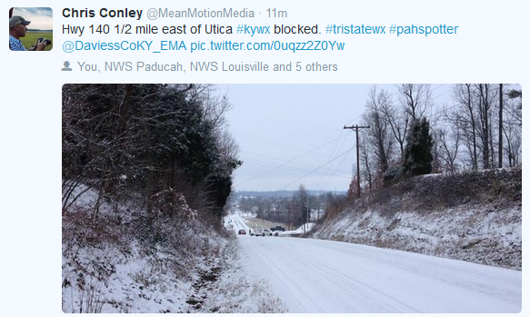
Numerous photographs indicated that many roadways became snow covered or partly snow covered. Under the snow was a thin layer of ice. Numerous accidents occurred across the area because of the icy roads.
The difficult part of this forecast was anticipating what the impact of the light snow event would be on area roadways. Or the extent of the problems. The National Weather Service mentioned hazardous road conditions in their special weather statements and on their Facebook page updates.
It is important to remember that light snow and ice events can cause a lot of travel disruption in our region. People become overconfident when they see just a hint of snow on the ground. “It isn’t that bad because there isn’t that much snow” – this is how many people think. This leads to careless driving. Of course most accidents during winter storms can be contributed to careless driving. Whether there is 8″ of snow on the ground or a dusting of snow on the ground.
Would it surprise you if I told you accidents on icy roads kill at least twice the number of people annually than all other severe weather hazards COMBINED (tornadoes, hurricanes, lightning, floods, high winds). Annual injuries number well into the thousands, with many millions in property damage (icyroadsafety.com).
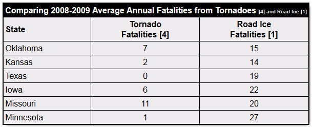
Imagine these statistics for a tornado outbreak in our region. Yet, these are not tornado deaths…these are winter storm deaths.
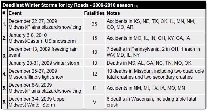
More people die in winter weather events than tornadoes. Yet, the attention is nowhere near the same.
These are topics that need to be considered and explored by forecasters and media. Are we spending enough time educating the public on these light winter precipitation events? Can we do a better job of informing the public of the threat to life and property?
As always, the public has a responsibility to use common sense during a weather event. But, that is true during severe weather season, as well. One can’t simply dismiss a hundred car accidents by blaming bad drivers. The same could be said about people who drive through flood waters, video tape tornadoes, stand out on a golf course during a lightning storm, or refuse to leave the coastline before a hurricane strikes.
The public has a responsibility and forecasters have a responsibility in dealing with these events.
Trusted weather sources…
It is also important to remember that you should use trusted weather sources for your weather information. There are a lot of Facebook and Twitter pages/accounts that post crazy snowfall maps days in advance of a winter storm. I do not support this behavior. It causes a lot of problems for those of us in the meteorological community. My policy is to issue a snowfall forecast map 24 hours before an event. Occasionally I might start posting maps 48 hours in advance. It depends on the storm.
We have a lot of great forecasters in our region. Our local media stations have great weather talent. We also have some great radio meteorologists. We have the National Weather Service Office located in Paducah, Kentucky. Utilize these resources.
Here is a satellite view of the snow that fell on Thursday morning. Thank you Louisville, Kentucky NWS
Here is a video for you die-hard winter weather fans. The challenges of forecasting winter weather events.
Thanks Kelly Heidbreder for the partial definition of banding.
Did you know that the Weather Observatory is funded by people like you? I rely on ad’s on this blog and individual donations. PayPal also allows you to set up a monthly donation. I have had several people give $5, $10, and $20 a month. A recurring donation helps keep the weather information flowing. If you enjoy this blog, the Twitter account, the Facebook interaction, the weather radars, and all of the other information then consider making a donation or setting up a recurring donation (if you don’t use PayPal then contact me through email about how you can mail your donation) beaudodson@usawx.com Thank you!