We have some great sponsors for the Weather Talk Blog. Please let our sponsors know that you appreciate their support for the Weather Talk Blog.
Milner and Orr Funeral Home and Cremation Services located in Paducah, Kentucky and three other western Kentucky towns – at Milner and Orr they believe in families helping families. You can find Milner and Orr on Facebook, as well.
![]()
.

Are you in need of new eye glasses? New contacts? Perhaps you need an eye exam. Then be sure and visit the Eye Care Associates of western Kentucky (the Paducah location).
For all of your families eye care needs. Visit their web-site here. Or, you can also visit their Facebook page.
.

Best at Enabling Body Shop Profitability since 1996. Located In Paducah Kentucky and Evansville Indiana; serving all customers in between. They provide Customer Service, along with all the tools necessary for body shops to remain educated and competitive. Click the logo above for their main web-site. You can find McClintock Preferred Finishes on Facebook, as well

Expressway Carwash and Express Lube are a locally owned and operated full service Carwash and Lube established in 1987. They have been proudly serving the community for 29 years now at their Park Avenue location and 20 years at their Southside location. They have been lucky enough to partner with Sidecar Deli in 2015, which allows them to provide their customers with not only quality service, but quality food as well. . If you haven’t already, be sure to make Expressway your one stop shop, with their carwash, lube and deli. For hours of operation and pricing visit www.expresswashlube.com or Expressway Carwash on Facebook.

TORNADO SHELTERS! Endrizzi’s Storm Shelters – For more information click here. Endrizzi Contracting and Landscaping can be found on Facebook, as well – click here
I have launched the new weather texting service! I could use your help. Be sure and sign up and fully support all of the weather data you see each day.
This is a monthly subscription service. Supporting this helps support everything else. The cost is $3 a month for one phone, $5 a month for three phones, and $10 a month for seven phones.
For more information visit BeauDodsonWeather.com
Or directly sign up at Weathertalk.com


This forecast update covers far southern Illinois, far southeast Missouri, and far western Kentucky. See the coverage map on the right side of the blog.
.
This forecast covers the counties in red.

This forecast covers the counties in red.
New! Video page on the main Weather Talk web-site.
I am posting videos each day on the WeatherTalk website.
The videos can be found under the BeauCast tab. Click here.
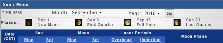
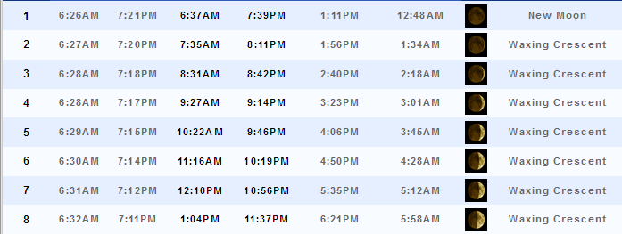
September 6, 2016
Sunset will be at 7:14 p.m.
Moonrise will be at 11:16 a.m. and moonset will be at 10:19 p.m. Waxing Crescent
.
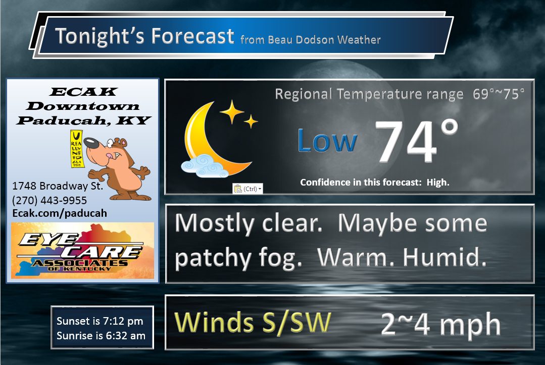
Tuesday Night – A few evening clouds. Otherwise, clear. Warm. Humid. Perhaps some patchy fog. Only a 10%-20% chance for an evening thunderstorm.
What impact is expected? If a storm forms then lightning. Otherwise, no significant impacts. Patchy fog possible.
Temperatures: Lows in the 70-75 degree range
Winds: Winds south and southwest at 3-6 mph.
What is the chance for precipitation? MO ~ 20%. IL ~ 10%. KY~ 10% . TN ~ 10%
Coverage of precipitation: Isolated to none.
Is severe weather expected? No
My confidence in this part of the forecast verifying: High. This forecast should verify.
Should I cancel my outdoor plans? No
.
Graphic-cast
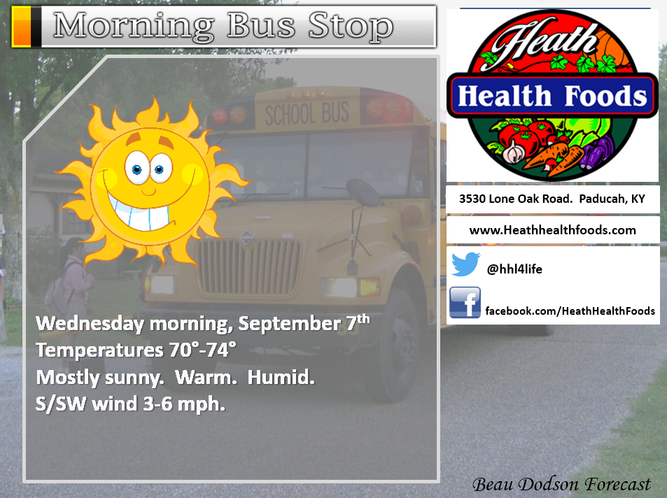
September 7, 2016
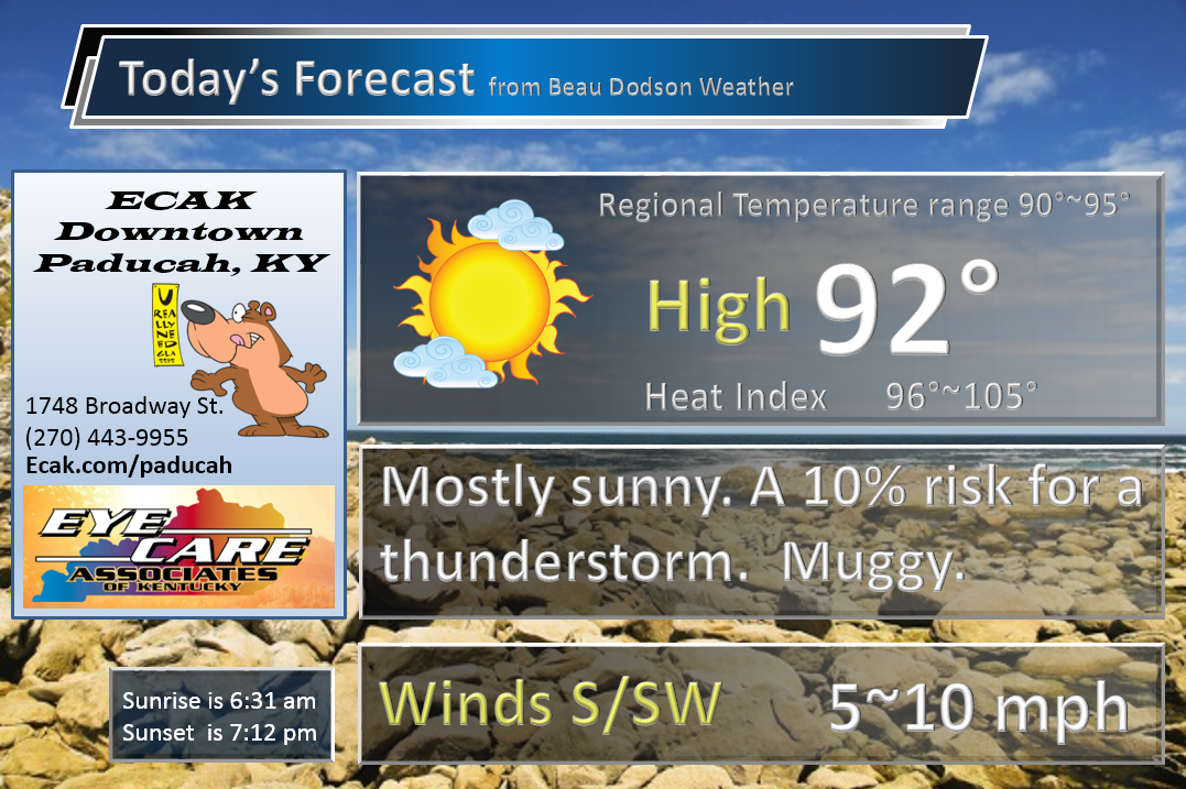
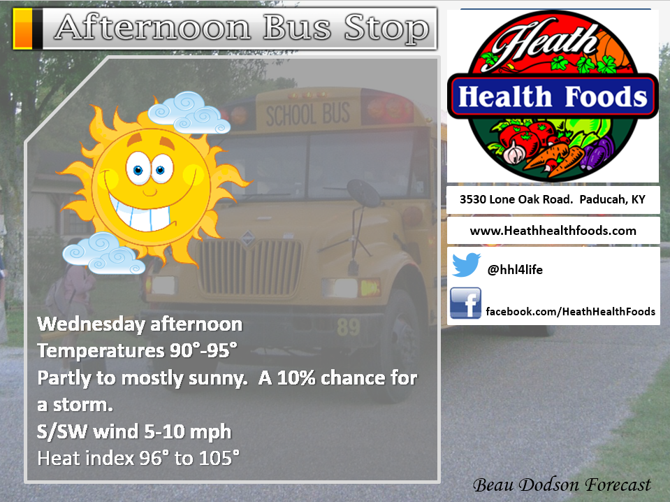
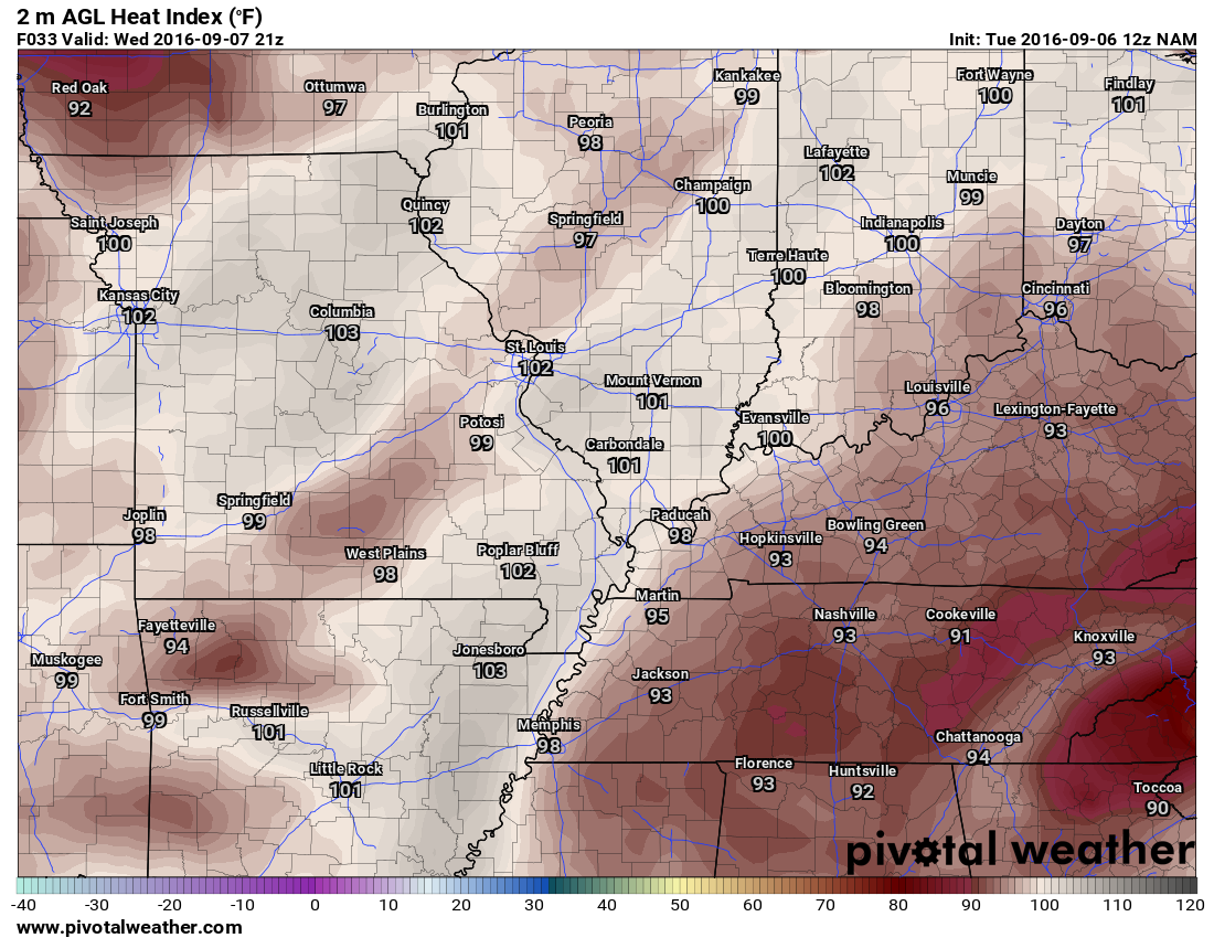
Wednesday: Partly sunny. Hot and humid. A slight chance for a heat of the day thunderstorm.
What impact is expected? Heat index values above 96 degrees. Small risk for lightning.
Temperatures: High temperatures in the 88-94 degree range.
Winds: South and southwest winds at 5-10 mph.
What is the chance for precipitation? MO ~ 20%. IL ~ 20%. KY ~ 20% . TN ~ 20%
Coverage of precipitation? I will be monitoring for heat of the day storms.
Is severe weather expected? No
My confidence in this part of the forecast verifying: High. This forecast should verify.
Should I cancel my outdoor plans? No
Sunrise will be at 6:31 a.m. and sunset will be at 7:12 p.m.
UV index will be 8-10. High.
Moonrise will be at 12:10 p.m. and moonset will be at 10:56 p.m. Waxing Crescent
.
Wednesday Night – Partly cloudy warm and muggy. An isolated thunderstorm possible.
What impact is expected? Most likely none. Perhaps lightning.
Temperatures: Lows in the 70-75 degree range
Winds: Winds south and southwest at 3-6 mph.
What is the chance for precipitation? MO ~ 20%. IL ~ 20%. KY~ 20% . TN ~ 20%
Coverage of precipitation: None to isolated.
Is severe weather expected? No
My confidence in this part of the forecast verifying: High. This forecast should verify.
Should I cancel my outdoor plans? No
.
September 8, 2016
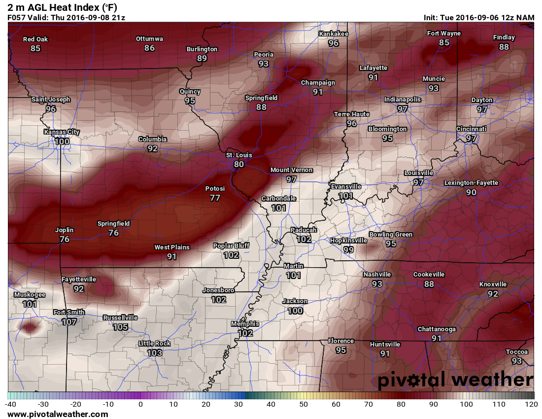
Thursday: Partly sunny. Hot and humid. A chance for showers and thunderstorms. Increasing chances from the north.
What impact is expected? Heat index values above 96 degrees. Wet roadways and lightning possible. Gusty winds near storms.
Temperatures: High temperatures in the 86-92 degree range.
Winds: South and southwest winds at 5-10 mph.
What is the chance for precipitation? MO ~ 40%. IL ~ 40%. KY ~ 30% . TN ~ 30%
Coverage of precipitation? Scattered.
Is severe weather expected? Unlikely.
My confidence in this part of the forecast verifying: High. This forecast should verify.
Should I cancel my outdoor plans? No
Sunrise will be at 6:32 a.m. and sunset will be at 7:11 p.m.
UV index will be 8-10. High.
Moonrise will be at 1:04 p.m. and moonset will be at 11:37 p.m. Waxing Crescent
.
Thursday Night – Mostly cloudy warm and muggy. A chance for showers and thunderstorms. A few locally heavy downpours possible.
What impact is expected? Wet roadways and lightning will be possible.
Temperatures: Lows in the 70-75 degree range
Winds: Winds south and southwest at 3-6 mph.
What is the chance for precipitation? MO ~ 60%. IL ~ 60%. KY~ 50% . TN ~ 40%
Coverage of precipitation: Scattered to perhaps numerous
Is severe weather expected? Unlikely
My confidence in this part of the forecast verifying: Medium. Some adjustments to the forecast might be necessary.
Should I cancel my outdoor plans? Have a plan B.
.
September 9, 2016
Friday: Partly sunny. Hot and humid. A chance for a thunderstorm.
What impact is expected? Heat index values above 94 degrees. Wet roadways and lightning possible.
Temperatures: High temperatures in the 86-92 degree range.
Winds: South and southwest winds at 5-10 mph.
What is the chance for precipitation? MO ~ 30%. IL ~ 30%. KY ~ 30% . TN ~ 30%
Coverage of precipitation? I will be monitoring for heat of the day storms.
Is severe weather expected? Unlikely.
My confidence in this part of the forecast verifying: Medium. Some adjustments to the forecast might be necessary.
Should I cancel my outdoor plans? No, but monitor updates
Sunrise will be at 6:32 a.m. and sunset will be at 7:09 p.m.
UV index will be 8-10. High.
Moonrise will be at 1:56 p.m. and moonset will be at –:– p.m. First Quarter
.
Friday Night – Partly cloudy warm and muggy. A chance for showers and thunderstorms.
What impact is expected? Wet roadways and lightning will be possible.
Temperatures: Lows in the 66-72 degree range
Winds: Winds southwest at 3-6 mph.
What is the chance for precipitation? MO ~ 50%. IL ~ 50%. KY~ 50% . TN ~ 50%
Coverage of precipitation: Perhaps scattered.
Is severe weather expected? Unlikely
My confidence in this part of the forecast verifying: Medium. Some adjustments to the forecast might be necessary.
Should I cancel my outdoor plans? No, but monitor updates.
.
September 10, 2016
Saturday: Partly sunny. A chance for showers and thunderstorms.
What impact is expected? Wet roadways and lightning possible.
Temperatures: High temperatures in the 80-86 degree range.
Winds: Southwest winds becoming west winds at 6-12 mph.
What is the chance for precipitation? MO ~ 60%. IL ~ 60%. KY ~ 60% . TN ~ 60%
Coverage of precipitation? Scattered. Monitor updates.
Is severe weather expected? Monitor updates.
My confidence in this part of the forecast verifying: Medium. Some adjustments to the forecast might be necessary.
Should I cancel my outdoor plans? No, but monitor updates
Sunrise will be at 6:33 a.m. and sunset will be at 7:08 p.m.
UV index will be 2-5. Low to moderate.
Moonrise will be at 2:47 p.m. and moonset will be at 12:21 p.m. Waxing Gibbous
.
Saturday Night – Decreasing clouds. Less humid. Cooler. An early evening shower or thunderstorm possible. Ending from west to east.
What impact is expected? Wet roadways and lightning will be possible.
Temperatures: Lows in the 56-64 degree range
Winds: Winds north at 3-6 mph.
What is the chance for precipitation? MO ~ 20%. IL ~ 30%. KY~ 40% . TN ~ 40%
Coverage of precipitation: Perhaps scattered early. Ending from west to east.
Is severe weather expected? Unlikely
My confidence in this part of the forecast verifying: Low. Significant adjustments to the forecast are possible.
Should I cancel my outdoor plans? No, but monitor updates.
.
September 11, 2016
Sunday: Mostly sunny. Cooler and less humid.
What impact is expected? Most likely none.
Temperatures: High temperatures in the 72-76 degree range.
Winds: South and southwest winds at 5-10 mph.
What is the chance for precipitation? MO ~ 10%. IL ~ 10%. KY ~ 10% . TN ~ 10%
Coverage of precipitation? None
Is severe weather expected? No
My confidence in this part of the forecast verifying: Low. Significant adjustments to the forecast are possible.
Should I cancel my outdoor plans? No
Sunrise will be at 6:34 a.m. and sunset will be at 7:06 p.m.
UV index will be 8-10. High.
Moonrise will be at 3:37 p.m. and moonset will be at 1:11 a.m. Waxing Gibbous
.
Sunday Night – Mostly clear. Cooler and less humid.
What impact is expected? Most likely none
Temperatures: Lows in the 54-58 degree range
Winds: Winds north at 2-4 mph.
What is the chance for precipitation? MO ~ 0%. IL ~ 0%. KY~ 0% . TN ~ 0%
Coverage of precipitation: None
Is severe weather expected? No
My confidence in this part of the forecast verifying: Low. Significant adjustments to the forecast are possible.
Should I cancel my outdoor plans? No
More information on the UV index. Click here
.
The School Bus Stop Forecast is sponsored by Heath Health and Wellness. Located next to Crowell Pools in Lone Oak, Kentucky.
Visit their web-site here. And. visit Heath Health Foods on Facebook!

Heath Health Foods is a locally owned and operated retail health and wellness store. Since opening in February 2006; the store has continued to grow as a ministry with an expanding inventory which also offers wellness appointments and services along with educational opportunities. Visit their web-site here. And. visit Heath Health Foods on Facebook!
The weekend forecast is sponsored by Farmer and Company Real Estate.

Farmer & Company Real Estate is proud to represent buyers and sellers in both Southern Illinois and Western Kentucky. With 13 licensed brokers, we can provide years of experience to buyers & sellers of homes, land & farms and commercial & investment properties. We look forward to representing YOU! Follow us on Facebook, as well
The weekend forecast is sponsored by Farmer and Company Real Estate. Click here to visit their site.

Don’t forget to check out the Southern Illinois Weather Observatory web-site for weather maps, tower cams, scanner feeds, radars, and much more! Click here

An explanation of what is happening in the atmosphere over the coming days
- Summer weather
- Relief is on the way
- Two cold fronts to monitor
- Extended period of cooler than normal temperatures?
The main weather story for the next couple of days will be the heat and humidity. We are used to this. It has been a long summer. I do have some great news. Relief is on the way.
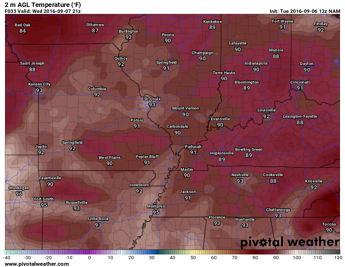
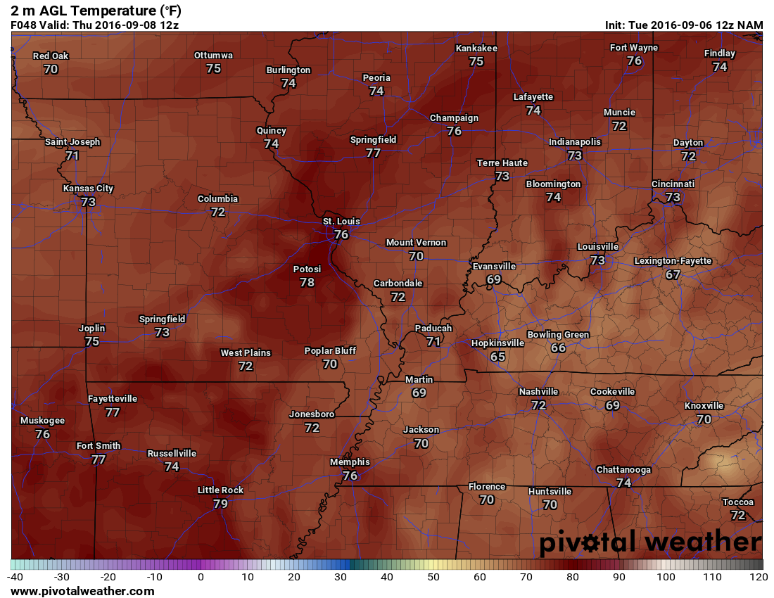
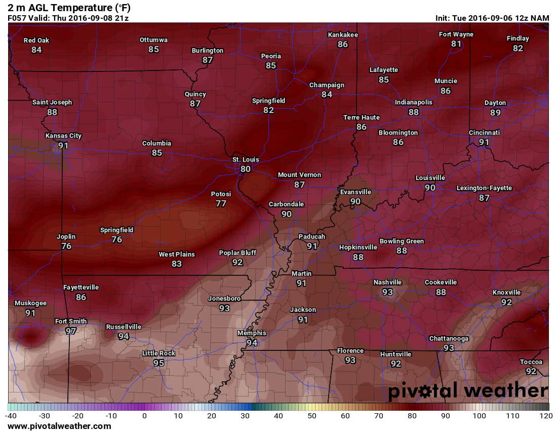
Here is the heat index map for Wednesday and Thursday. Notice anything odd about Thursday? That cooler air is because the NAM guidance is attempting to produce showers and thunderstorms over portions of the region. Confidence in that happening is fairly low. I will be monitoring trends in the guidance.
Wednesday heat index values
Thursday heat index values
I am monitoring two cold fronts. The first front will arrive on Friday night and Saturday. The second front will arrive towards the middle of next week. Both cold fronts are strong. That means they have lower dew points and lower temperatures following their passage.
There will be a decent chance for showers and thunderstorms on Friday and Saturday. Some guidance attempts to bring showers and storms into the region as early as Thursday. I will need to keep an eye on this portion of the forecast. I suspect we will have 50% shower/storm chances by Friday night into Saturday.
There remain some questions on what time the cold front will pass through our region. The most likely time frame is between 9 am and 2 pm on Saturday. Showers and storms will accompany the front. Some of the storms could be on the strong side. Let’s keep an eye on this, as well.
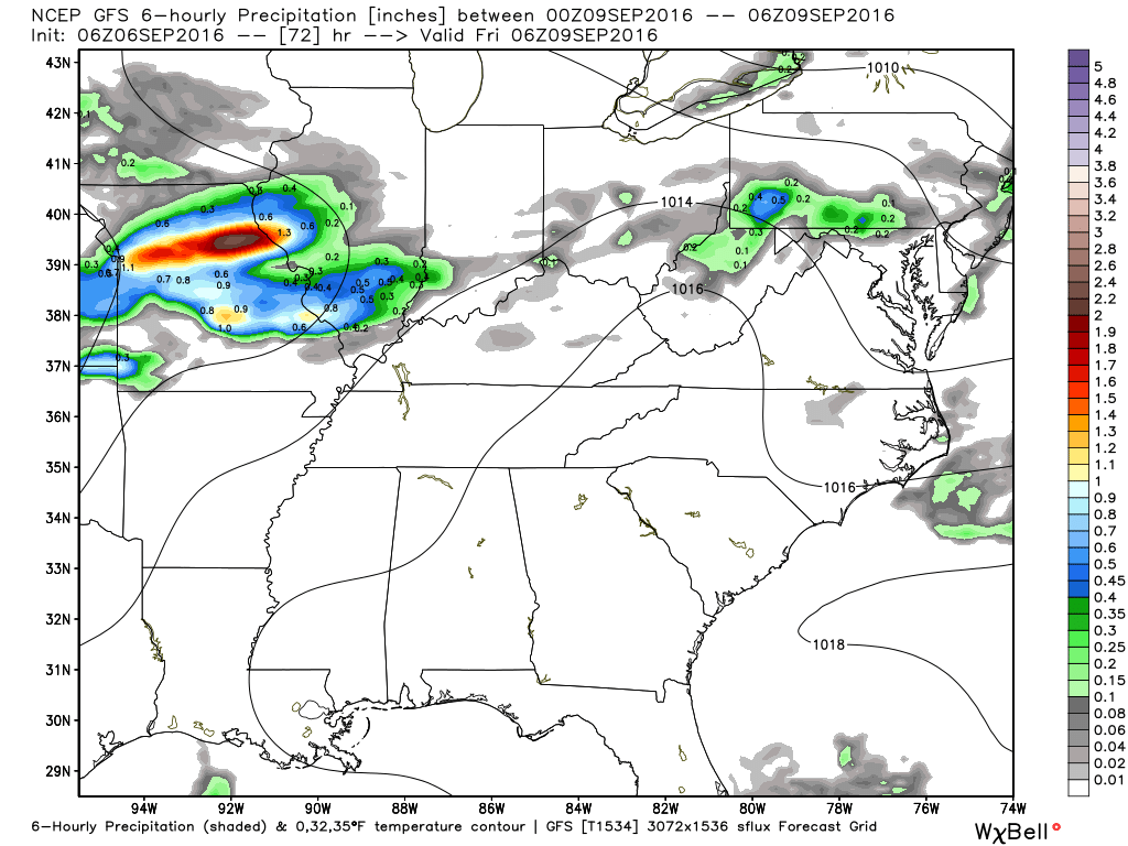
Let me show you some GFS model rainfall maps. These are six hour rainfall totals.
Here is what the GFS is showing for Thursday night. It does show showers and storms over portions of our region. This will need to be monitored. There is still some debate on precipitation coverage.
These are the rainfall totals from 7 pm on Thursday through 1 am on Friday morning.
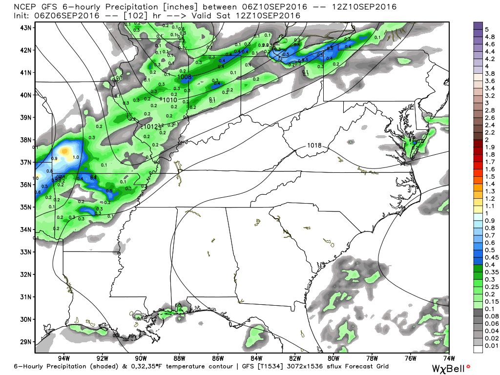
This next map is for 1 am on Saturday morning through 7 am on Saturday morning. You can tell where the cold front is situated, according to the GFS model guidance.
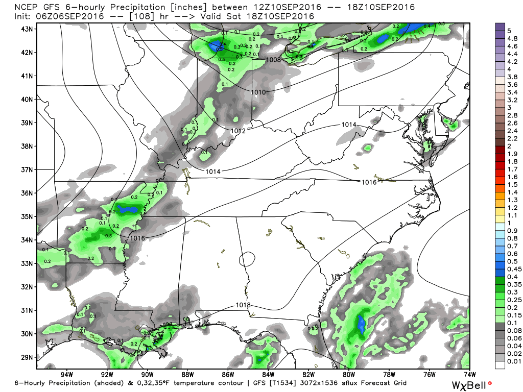
This next map (below) is from 7 am on Saturday morning through 1 pm on Saturday afternoon. The front is moving through our region. The GFS guidance is rather light on its precipitation totals. This is another part of the forecast that will need to be fine tuned.
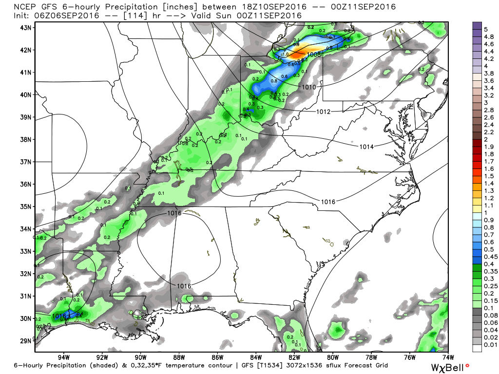
This next map is for 7 pm on Saturday through 1 am on Sunday morning. The GFS moves the front through our entire region during that time frame. It could be faster than the GFS is showing. Again, this will need to be monitored.
Let me show you the NAM guidance. Is shows quite a bit of shower and thunderstorm activity as early as Thursday night and Friday. Confidence on this happening is low. It is possible the ridge of high pressure, that has been in control of our regions weather, will be a bit more difficult to break down.
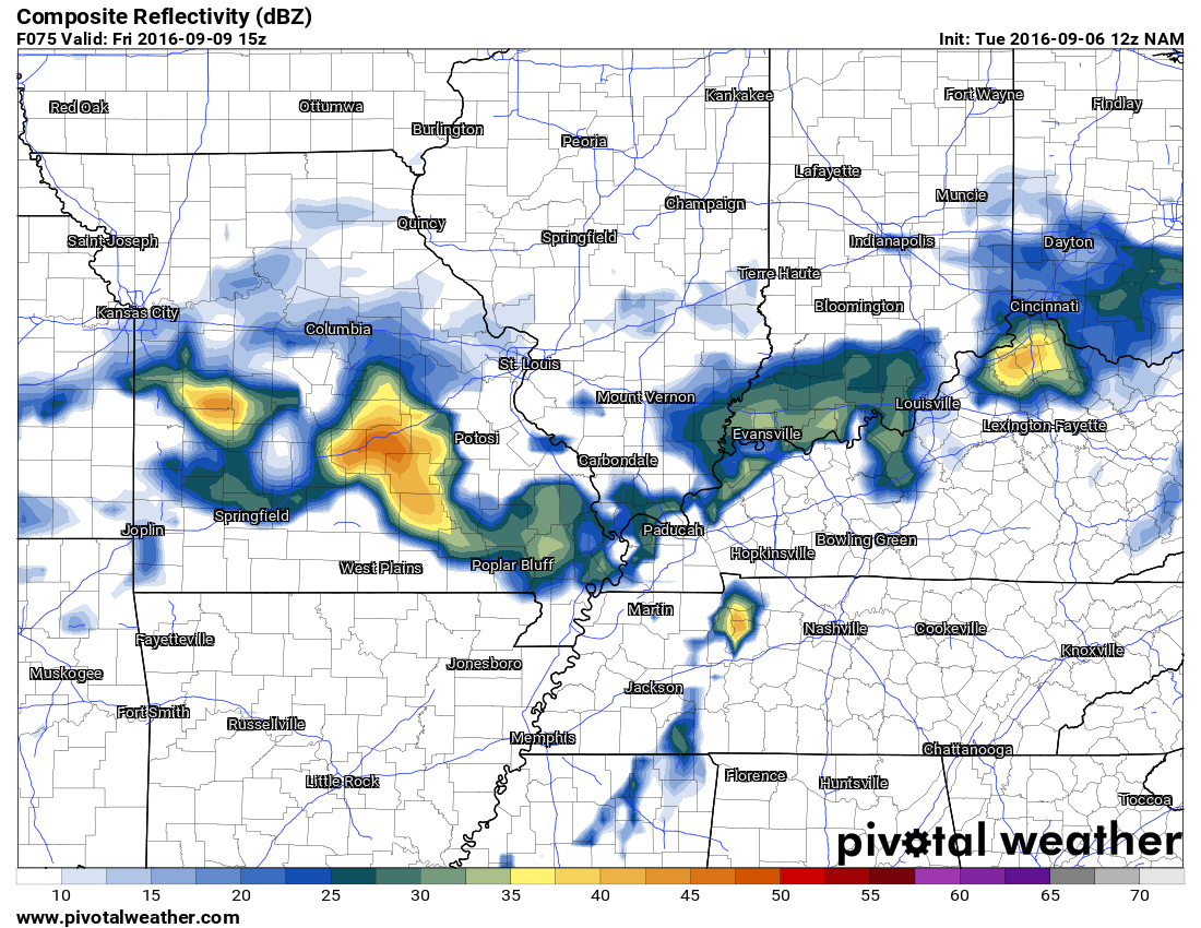
These are future-cast radar images. What radar might look like. Images are from weatherbell.com
Click images for a larger view
Thursday at 4 pm
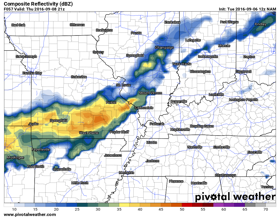
Thursday at 7 pm
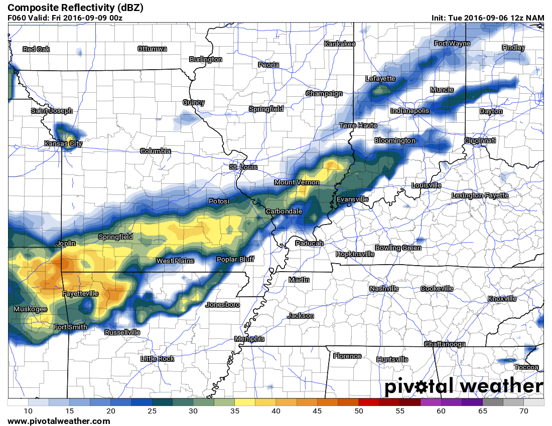
Thursday at 10 pm
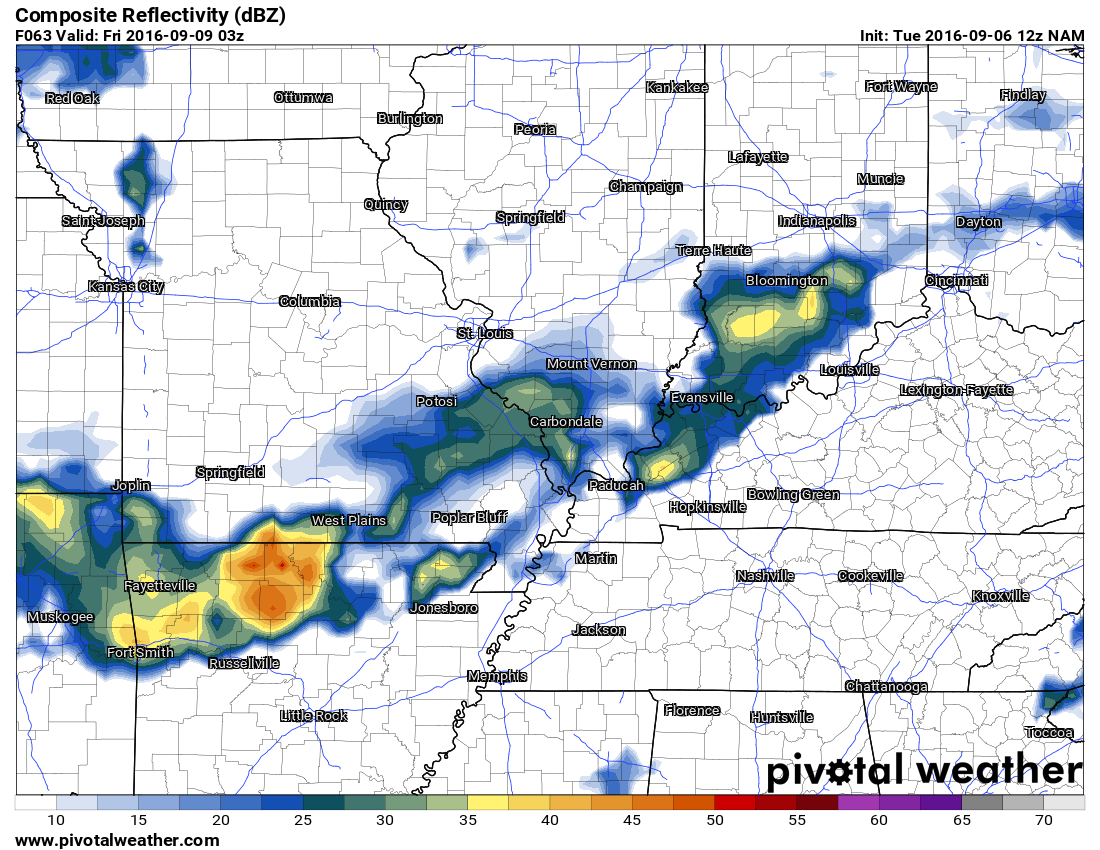
Friday at 1 am
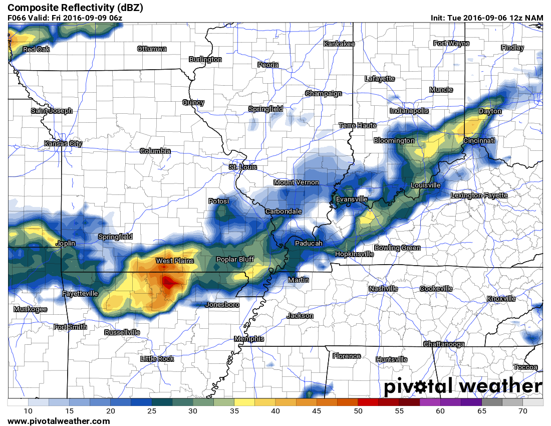
Friday at 4 am
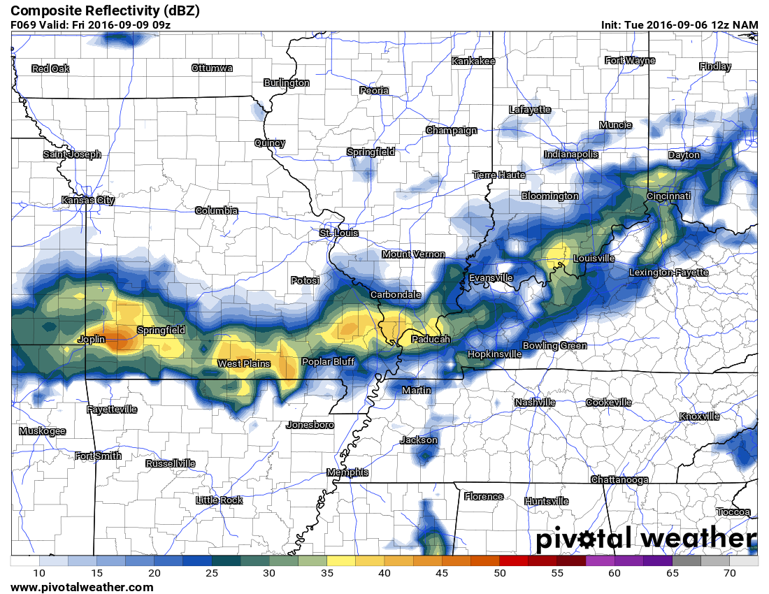
Friday at 7 am
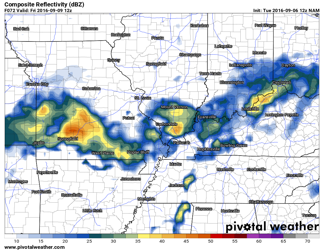
Friday at 10 am
Beyond this next cold front:
Cooler and drier air arrives on Saturday afternoon and night. Temperatures by Sunday morning will likely drop into the upper 50’s and lower 60’s. Daytime highs on Sunday may remain in the 70’s. That would be nice weather for our region.
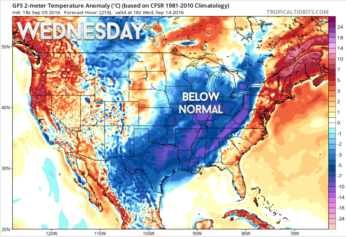
A stronger cold front is forecast for next week. That front will drop temperatures even further. A prolonged period of normal to below normal temperatures appears in the cards after Saturday’s cold front. Not saying we are finished with hot and muggy weather, however, I think we are stepping our way into a fall pattern.
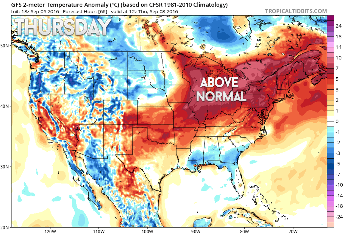
Let me show you the temperature anomaly maps for the coming 7-10 day period.
We will experience above normal temperatures through at least Thursday. Normal high temperatures, for this time of the year, are in the lower to middle 80’s. Normal low temperatures are in the lower 60’s.
This is the temperature anomaly map for Thursday. Red is warmer than normal. Clearly we are in the red!
Click the image to enlarge.
Let’s move ahead to Sunday. Check it out! We drop below normal behind the cold front.
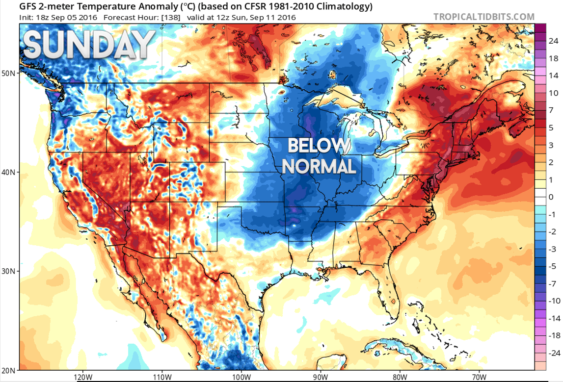
Look what happens next week. Even cooler temperature anomalies. Great news for those who love fall weather.
I always like to remind people that we normally see an uptick in severe weather during October and November.
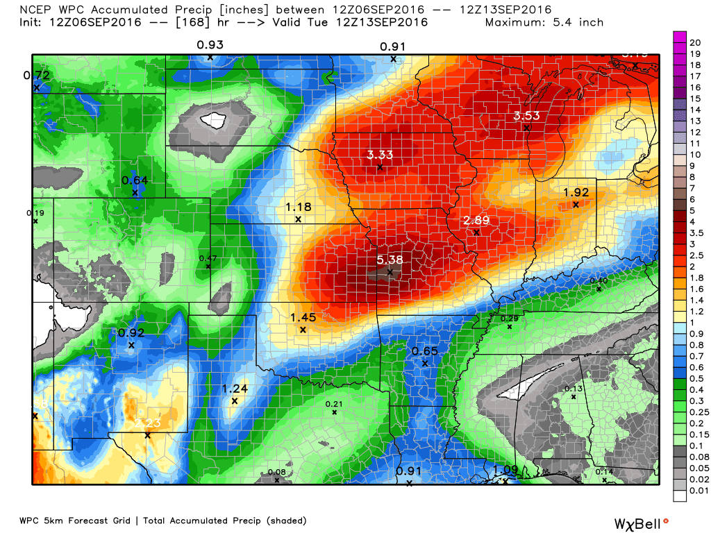
How much rain is forecast to fall over the coming days?
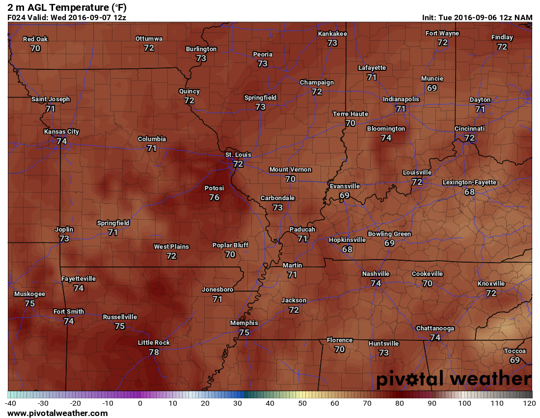
Wednesday afternoon high temperature map
Thursday morning low temperatures
Thursday afternoon high temperature
Storm Tracking Radar


We have regional radars and local city radars – if a radar does not seem to be updating then try another one. Occasional browsers need their cache cleared. You may also try restarting your browser. That usually fixes the problem. Occasionally we do have a radar go down. That is why I have duplicates. Thus, if one fails then try another one.
If you have any problems then please send me an email beaudodson@usawx.com
WEATHER RADAR PAGE – Click here —
We also have a new national interactive radar – you can view that radar by clicking here.
Local interactive city radars include St Louis, Mt Vernon, Evansville, Poplar Bluff, Cape Girardeau, Marion, Paducah, Hopkinsville, Memphis, Nashville, Dyersburg, and all of eastern Kentucky – these are interactive radars. Local city radars – click here

Live Lightning Data – zoom and pan: Click here
Live Lightning Data with sound (click the sound button on the left side of the page): Click here

Can we expect severe thunderstorms over the next 24 to 48 hours? Remember that a severe thunderstorm is defined as a thunderstorm that produces 58 mph winds or higher, quarter size hail or larger, and/or a tornado.
.
Tuesday night through Thursday: Perhaps a few isolated storms for the area.
Thursday night and Friday: I will be monitoring for possible storms moving in from the west and north. Low confidence.
Friday night and Saturday: A cold front pushes into the region. Some strong storms can’t be ruled out. The timing of the front will be one of the deciding factors as to the intensity of the storms.
Saturday night into Monday: Evening storms on Saturday (depending on the speed of the cold front). Otherwise, storms are not anticipated during this time frame.
.

.
Rain chances for Thursday night into Friday may need to be updated. Lower confidence during that time period.
.

.
Heat index values will pop back up above 96 degrees over the coming days.
.

Here are the current river stage forecasts. You can click your state and then the dot for your location. It will bring up the full forecast and hydrograph.
..

Here is the official 6-10 day and 8-14 day temperature and precipitation outlook. Check the date stamp at the top of each image (so you understand the time frame).
The forecast maps below are issued by the Weather Prediction Center (NOAA).


The latest 8-14 day temperature and precipitation outlook. Note the dates are at the top of the image. These maps DO NOT tell you how high or low temperatures or precipitation will be. They simply give you the probability as to whether temperatures or precipitation will be above or below normal.


Who do you trust for your weather information and who holds them accountable?
I have studied weather in our region since the late 1970’s. I have 37 years of experience in observing our regions weather patterns. My degree is in Broadcast Meteorology from Mississippi State University and an Associate of Science (AS). I am currently working on my Bachelor’s Degree in Geoscience.
My resume includes:
Member of the American Meteorological Society.
NOAA Weather-Ready Nation Ambassador.
Meteorologist for McCracken County Emergency Management. I served from 2005 through 2015.
I own and operate the Southern Illinois Weather Observatory.
Recipient of the Mark Trail Award, WPSD Six Who Make A Difference Award, Kentucky Colonel, and the Caesar J. Fiamma” Award from the American Red Cross.
In 2009 I was presented with the Kentucky Office of Highway Safety Award.
Recognized by the Kentucky House of Representatives for my service to the State of Kentucky leading up to several winter storms and severe weather outbreaks.
I am also President of the Shadow Angel Foundation which serves portions of western Kentucky and southern Illinois.
There is a lot of noise on the internet. A lot of weather maps are posted without explanation. Over time you should learn who to trust for your weather information.
My forecast philosophy is simple and straight forward.
- Communicate in simple terms
- To be as accurate as possible within a reasonable time frame before an event
- Interact with you on Twitter, Facebook, and the blog
- Minimize the “hype” that you might see on television or through other weather sources
- Push you towards utilizing wall-to-wall LOCAL TV coverage during severe weather events
I am a recipient of the Mark Trail Award, WPSD Six Who Make A Difference Award, Kentucky Colonel, and the Caesar J. Fiamma” Award from the American Red Cross. In 2009 I was presented with the Kentucky Office of Highway Safety Award. I was recognized by the Kentucky House of Representatives for my service to the State of Kentucky leading up to several winter storms and severe weather outbreaks.
If you click on the image below you can read the Kentucky House of Representatives Resolution.

Many of my graphics are from www.weatherbell.com – a great resource for weather data, model data, and more


You can sign up for my AWARE email by clicking here I typically send out AWARE emails before severe weather, winter storms, or other active weather situations. I do not email watches or warnings. The emails are a basic “heads up” concerning incoming weather conditions.