

.
You must have a Weather Talk subscription ($3 a month) to view the videos.
Videos are posted on the www.weathertalk.com website. Once there, click the Beau Video-Cast tab. Long Range Video Update
If you believe you missed a video then you can also click the LIVE FEED link on the Weather Talk website. You will find the most recent and previous seven days worth of links on that page.
I can app/text you the videos, as well. Make sure you have text option FOUR turned on. That would be the Weather Extra text option. Sign up for the app/text messages, videos, and more at www.beaudodsonweather.com
.

.
This forecast update covers southern Illinois, southeast Missouri, western Kentucky. and extreme northwest Tennessee.
.
September 4, 2017
Monday Night Forecast Details:
.
Interactive Weather Radar Page. Choose the city nearest your location: Click this link
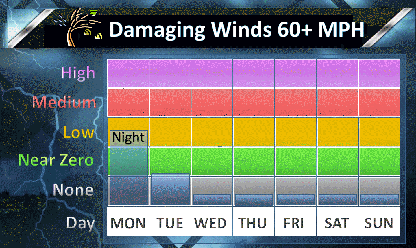
Forecast: Increasing clouds. A good chance for a line of showers and thunderstorms moving north to south. Locally heavy rain possible. Some storms could produce strong winds. There is a low end severe weather risk. Northern parts of southeast Missouri and northern parts of southern Illinois would have the greatest chance for a few intense thunderstorms with damaging winds. The risk decreases as you move further and further south.
Temperatures: MO ~ 63 to 66 IL ~ 60 to 65 KY ~ 63 to 66 TN ~ 64 to 68
Winds: South and southwest winds at 7 to 14 mph and gusty. Winds behind the cold front will become north/northwest.
What impacts are anticipated from the weather? Wet roadways. Lightning, Gusty winds. A few intense storms possible.
My confidence in the forecast verifying: High. This forecast should verify.
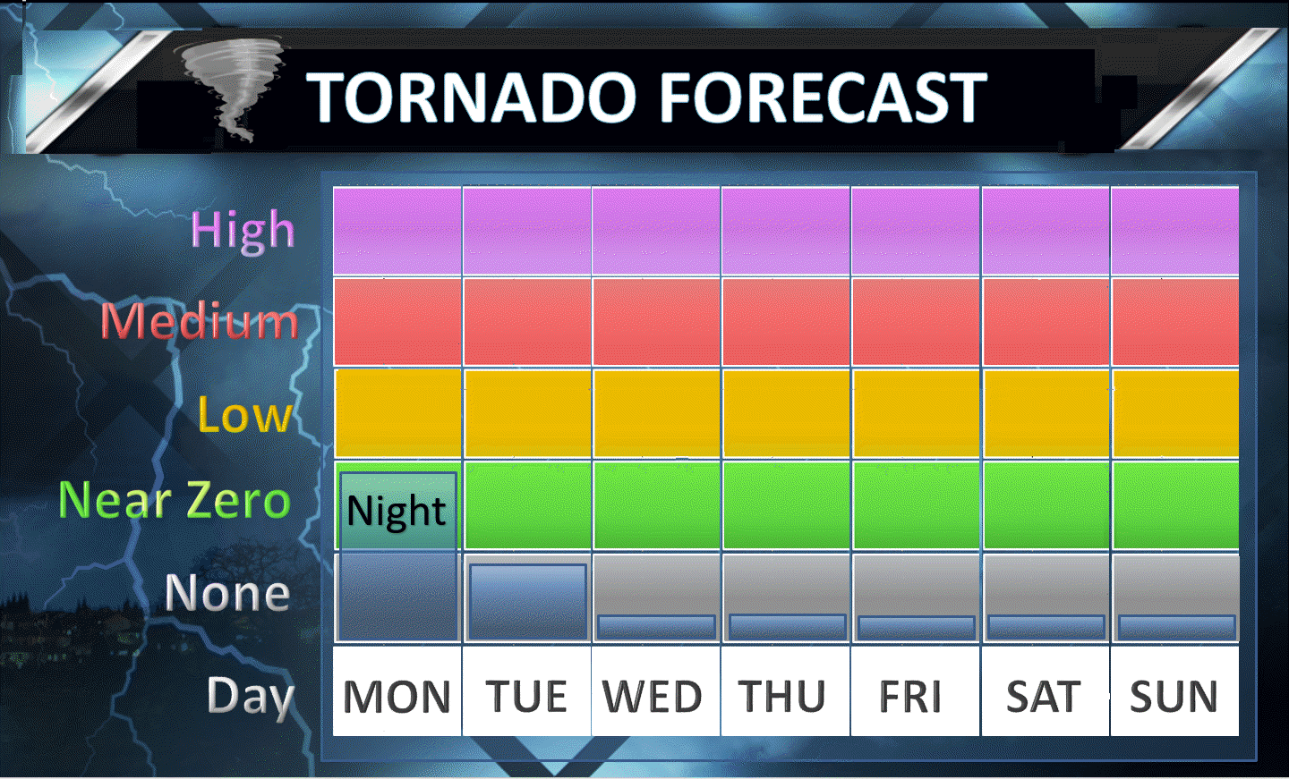
Is severe weather expected? Low end risk for a few severe thunderstorm warnings.
The NWS defines severe weather as 58 mph winds or great, 1″ hail or larger, and/or tornadoes
What is the chance of precipitation? MO ~ 60% IL ~ 70% KY ~ 60% TN ~ 50%
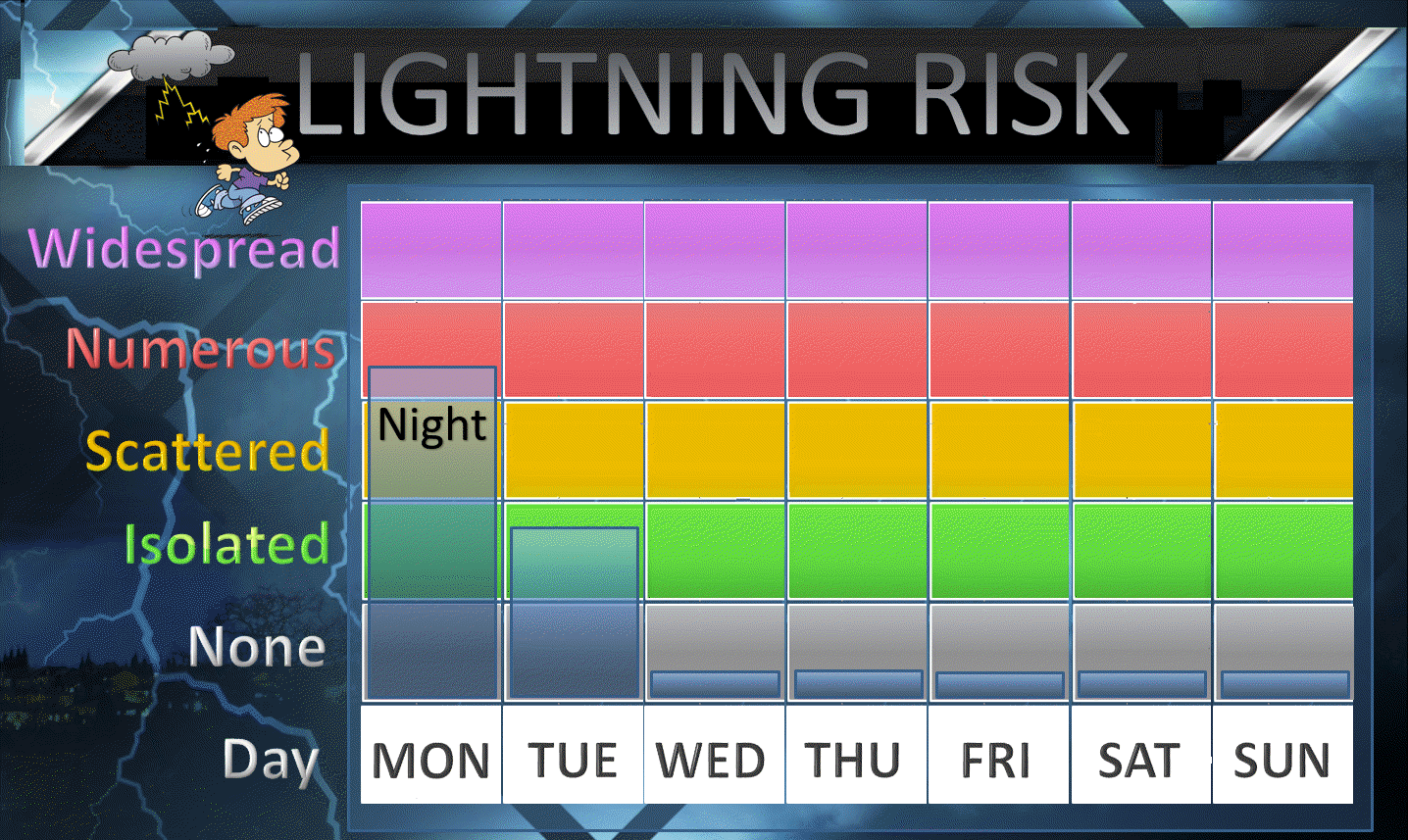
Coverage of precipitation: Scattered to perhaps numerous showers and storms along an incoming cold front.
Should I cancel my outdoor plans? Early in the evening should be fine. After 9 pm we should have storms approaching from the north.
.
.
September 5, 2017
Tuesday Forecast Details
Forecast: Some morning clouds. A few morning showers and thunderstorms. Remaining showers and storms may linger in the Pennyrile area of western Kentucky and near the KY/TN border and the Bootheel of Missouri. Cooler. Less humid. Cold front will have passed through the region. This will usher in below normal temperatures.
Temperatures: MO ~ 75 to 80 IL ~ 75 to 80 KY ~ 75 to 80 TN ~ 76 to 82
Winds: North winds 4 to 8 mph
What impacts are anticipated from the weather? Perhaps some wet roadways and lightning in the morning. Most of the precipitation should have shifted southward. Small chance for afternoon showers/storms. Believe most of the region will be dry for the best part of Tuesday.
My confidence in the forecast verifying: Medium. Some adjustments are possible.
Is severe weather expected? Unlikely
The NWS defines severe weather as 58 mph winds or great, 1″ hail or larger, and/or tornadoes
What is the chance of precipitation? MO ~ 40% (early) IL ~ 30% (early) KY ~ 50% mainly before 12 pm TN ~ 50%
Coverage of precipitation: A band of showers and storms ending from north to south early in the day.
Should I cancel my outdoor plans? Monitor radars.
.
Tuesday Night Forecast Details:
Forecast: Mostly clear. Cooler. Less humid. Pleasant night anticipated. Patchy fog possible.
Temperatures: MO ~ 48 to 54 IL ~ 46 to 52 KY ~ 48 to 52 TN ~ 50 to 55
Winds: North winds at 3 to 6 mph becoming calm
What impacts are anticipated from the weather? Perhaps lower visibility if fog develops
My confidence in the forecast verifying: High. This forecast should verify.
Is severe weather expected? No
The NWS defines severe weather as 58 mph winds or great, 1″ hail or larger, and/or tornadoes
What is the chance of precipitation? MO ~ 0% IL ~ 0% KY ~ 0% TN ~ 0%
Coverage of precipitation: None
Should I cancel my outdoor plans? No
.
.
September 6, 2017
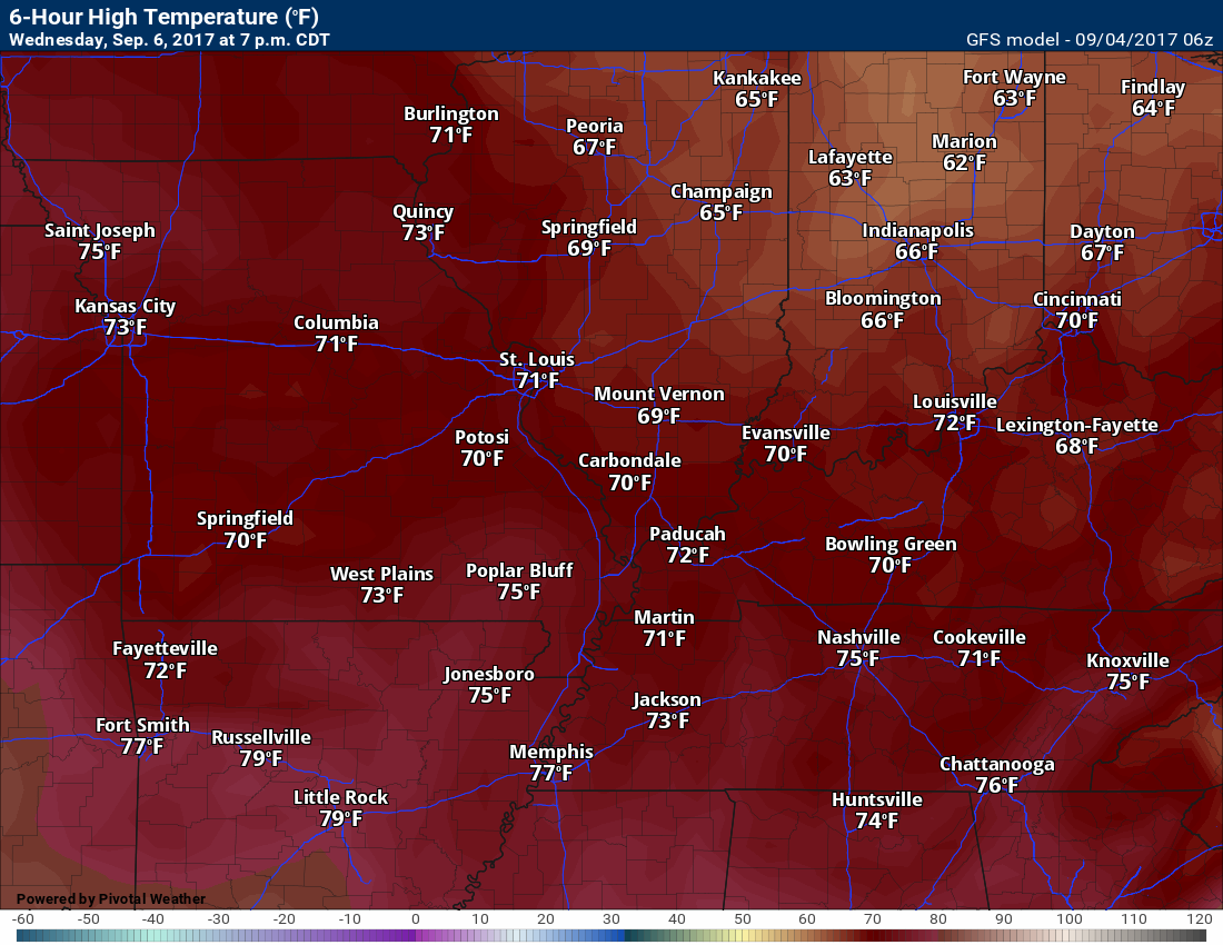
Wednesday Forecast Details
Forecast: Mostly sunny. Pleasant day. Low humidity.
Temperatures: MO ~ 70 to 75 IL ~ 70 to 75 KY ~ 70 to 75 TN ~ 70 to 75
Winds: North and northwest winds at 4 to 8 mph
What impacts are anticipated from the weather? Lower visibility if morning fog develops
My confidence in the forecast verifying: High. This forecast should verify
Is severe weather expected? No
The NWS defines severe weather as 58 mph winds or great, 1″ hail or larger, and/or tornadoes
What is the chance of precipitation? MO ~ 0% IL ~ 0% KY ~ 0% TN ~ 0%
Coverage of precipitation: None
Should I cancel my outdoor plans? No
.
Wednesday Night Forecast Details:
Forecast: Mostly clear. Cool. Pleasant early September night. Patchy fog possible.
Temperatures: MO ~ 45 to 50 IL ~ 45 to 50 KY ~ 45 to 50 TN ~ 45 to 50
Winds: North and northwest winds at 4 to 8 mph
What impacts are anticipated from the weather? Lower visibility if fog forms
My confidence in the forecast verifying: High. This forecast should verify.
Is severe weather expected? No
The NWS defines severe weather as 58 mph winds or great, 1″ hail or larger, and/or tornadoes
What is the chance of precipitation? MO ~ 0% IL ~ 0% KY ~ 0% TN ~ 0%
Coverage of precipitation: None
Should I cancel my outdoor plans? No
.
.
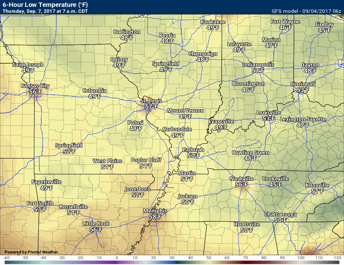
September 7, 2017
Thursday Forecast Details
Forecast: Mostly sunny. Pleasant with low humidity levels.
Temperatures: MO ~ 73 to 76 IL ~ 73 to 76 KY ~ 73 to 76 TN ~ 73 to 76
Winds: North and northwest at 4 to 8 mph
What impacts are anticipated from the weather? None
My confidence in the forecast verifying: High. This forecast should verify.
Is severe weather expected? No
The NWS defines severe weather as 58 mph winds or great, 1″ hail or larger, and/or tornadoes
What is the chance of precipitation? MO ~ 0% IL ~ 0% KY ~ 0% TN ~ 0%
Coverage of precipitation: None
Should I cancel my outdoor plans? No
.
Thursday Night Forecast Details:
Forecast: Mostly clear. Cool. Pleasant night. Patchy fog.
Temperatures: MO ~ 48 to 52 IL ~ 46 to 52 KY ~ 46 to 52 TN ~ 46 to 52
Winds: Light winds
What impacts are anticipated from the weather? None (patchy morning fog)
My confidence in the forecast verifying: High. This forecast should verify
Is severe weather expected? No
The NWS defines severe weather as 58 mph winds or great, 1″ hail or larger, and/or tornadoes
What is the chance of precipitation? MO ~ 0% IL ~ 0% KY ~ 0% TN ~ 0%
Coverage of precipitation: None
Should I cancel my outdoor plans? No
.
.
September 8, 2017
Friday Forecast Details
Forecast: Partly to mostly sunny. Pleasant temperatures.
Temperatures: MO ~ 74 to 78 IL ~ 74 to 78 KY ~ 74 to 78 TN ~ 74 to 78
Winds: Light and variable
What impacts are anticipated from the weather? None
My confidence in the forecast verifying: High
Is severe weather expected? No
The NWS defines severe weather as 58 mph winds or great, 1″ hail or larger, and/or tornadoes
What is the chance of precipitation? MO ~ 0% IL ~ 0% KY ~ 0% TN ~ 0%
Coverage of precipitation: None
Should I cancel my outdoor plans? No
.
Friday Night Forecast Details:
Forecast: Mostly clear.
Temperatures: MO ~ 48 to 52 IL ~ 48 to 52 KY ~ 50 to 55 TN ~ 50 to 55
Winds: Light and variable at 5 mph
What impacts are anticipated from the weather? None
My confidence in the forecast verifying: High
Is severe weather expected? No
The NWS defines severe weather as 58 mph winds or great, 1″ hail or larger, and/or tornadoes
What is the chance of precipitation? MO ~ 0% IL ~ 0% KY ~ 0% TN ~ 0%
Coverage of precipitation: None
Should I cancel my outdoor plans? No
.
I am keeping a close eye on Irma. See below.

Don’t forget to check out the Southern Illinois Weather Observatory web-site for weather maps, tower cams, scanner feeds, radars, and much more! Click here

A severe thunderstorm is defined as a storm that produces quarter size hail or larger, 58 mph winds or greater, and/or a tornado. That is the official National Weather Service definition of a severe thunderstorm
Monday night through Tuesday: Thunderstorms are possible Monday night into Tuesday. A few storms could be strong with gusty winds, small hail, frequent lightning, and heavy downpours. There is a low end risk for severe thunderstorms.
Most of the storms should occur on Monday night/early Tuesday.
.
Tuesday night through Friday: Severe weather is not anticipated.
Tornado outlook
Damaging winds
Hail

Lightning

Overview
Are there any weather concerns?
- Thunderstorms on Monday night/Tuesday morning
- Tracking Hurricane Irma in the long range
Short range
Confidence level in the short range forecast is medium to high
The main weather concern, for the next 12 to 24 hours, will be a cold front approaching from the north. This front will push through the region late Monday night into Tuesday morning. A band of showers and thunderstorms will accompany the front. A few intense storms are possible.
The storms will move north to south at speeds of 25 to 35 mph. Some southeast movement is also anticipated.
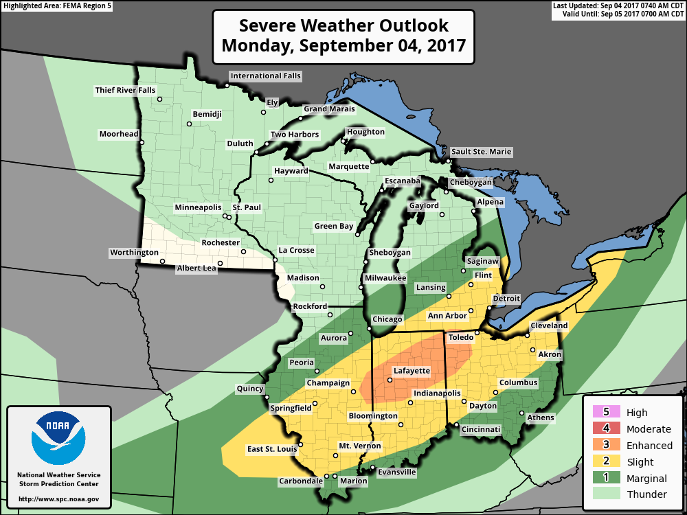
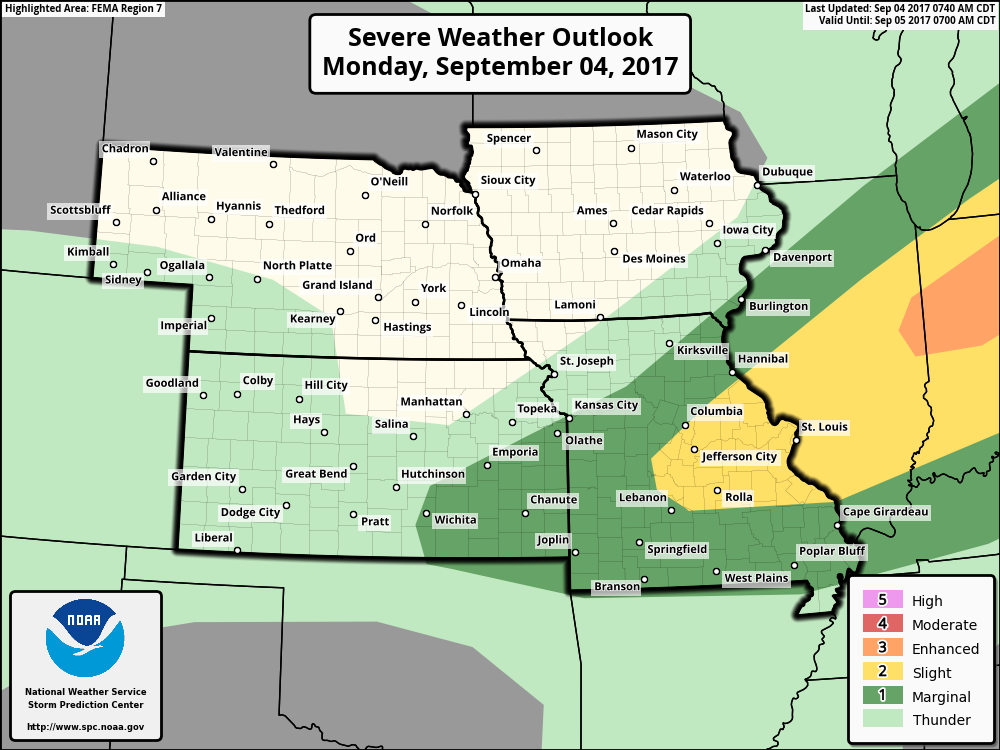
Here is the official Storm Prediction Center’s severe weather outlook (visit the SPC website for the most current outlook)
Dark green is the marginal risk zone. A level 1 out of 5 risk. One being the lowest.
Yellow is the slight risk zone. A level 2 out of 5 risk.
Light green is for non-severe thunderstorms.
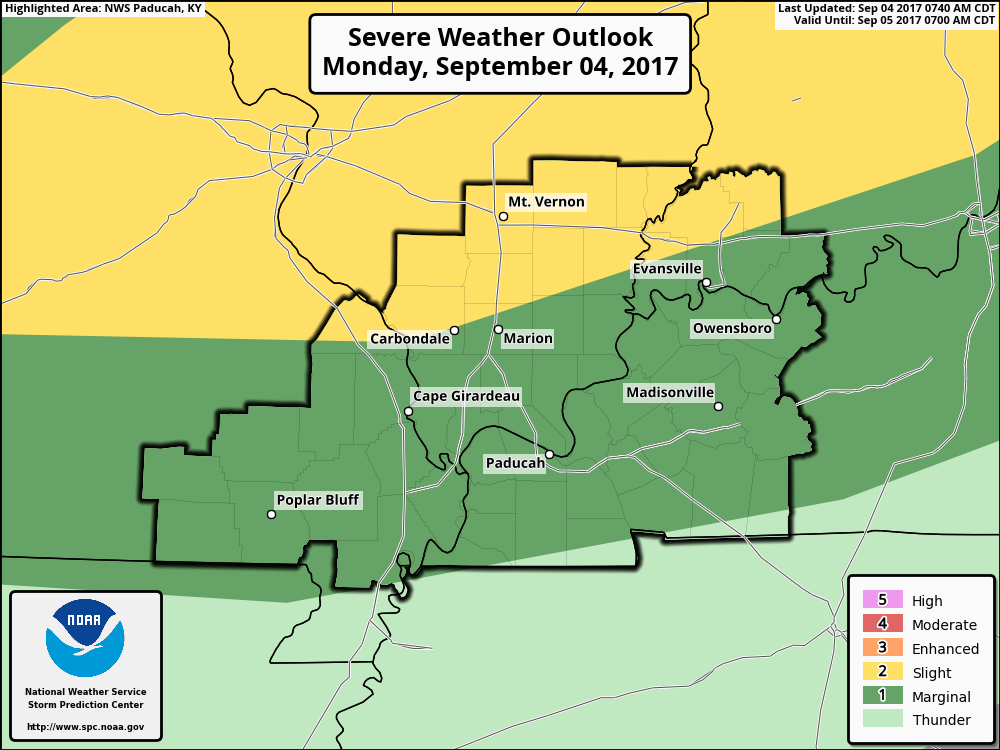
Zoomed out
The cold front will usher in below normal temperatures as we push into Tuesday. Those below normal temperatures will likely continue into the weekend. A fallish start for September.
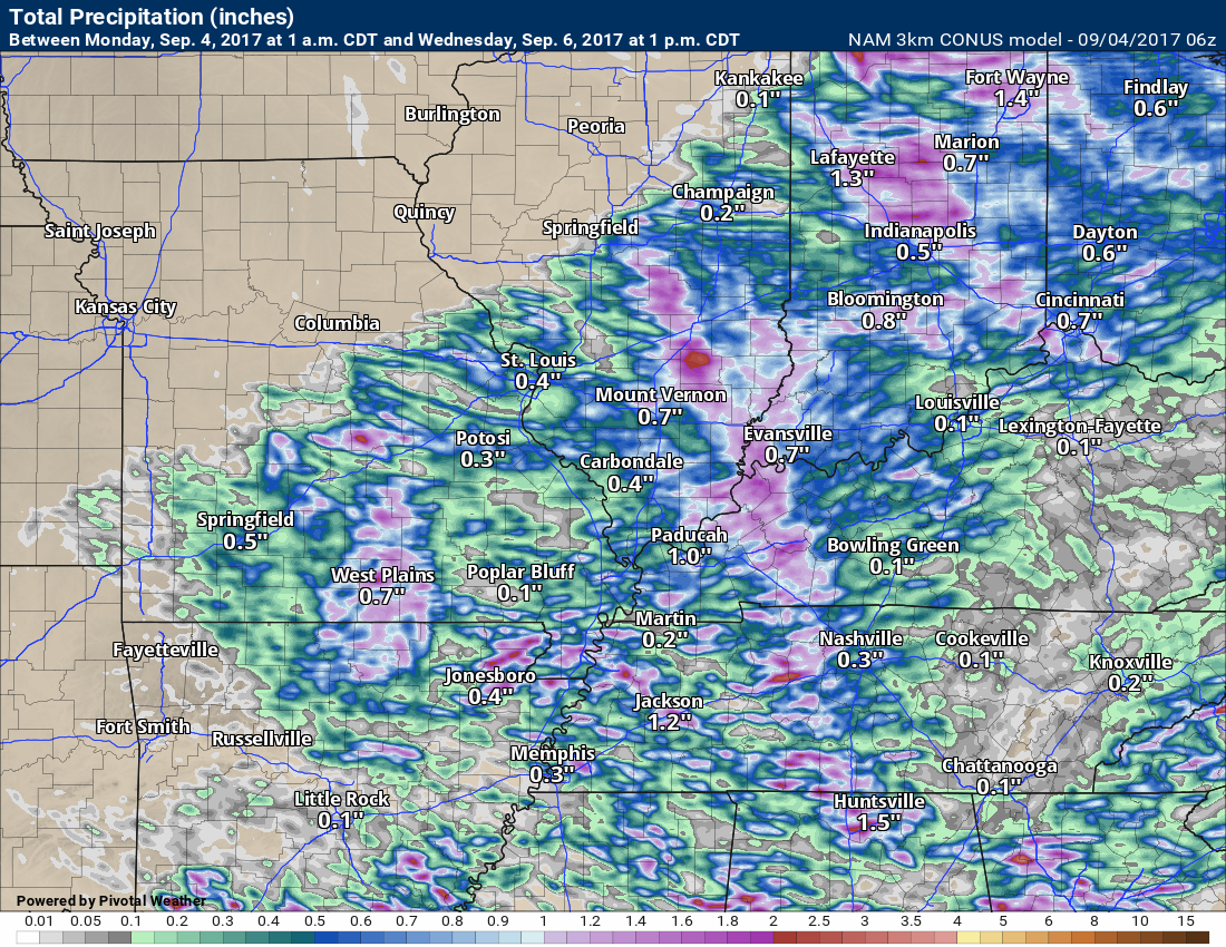
Here is the 3K NAM model depiction of the line of thunderstorms as it pushes in from the north on Monday night. Time stamps at the top on the left. Keep in mind, this is a models opinion. The actual line could be a bit slower or faster. Check radars to follow its progress.
Interactive Weather Radar Page. Choose the city nearest your location: Click this link
Rainfall totals, on Monday night and Tuesday, will vary. Thunderstorms can always double your rain amount in a short amount of time.
Generally, most areas can expect 0.25″ to 0.40″. It is possible some areas receive very little in the way of measurable rainfall.
Here is the high res 3K NAM model. This is its opinion on rainfall totals.
Click images to enlarge
Here is the GFS model
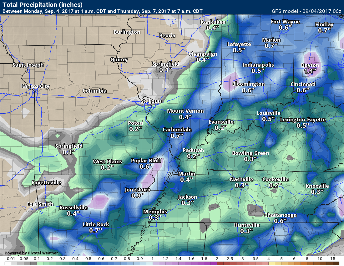
Here is the Canadian model
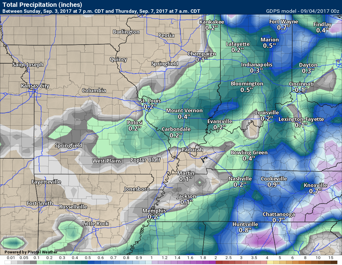
As you can see, different opinions from the models.
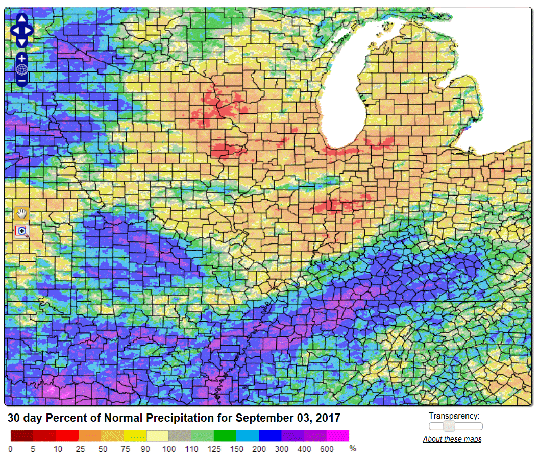
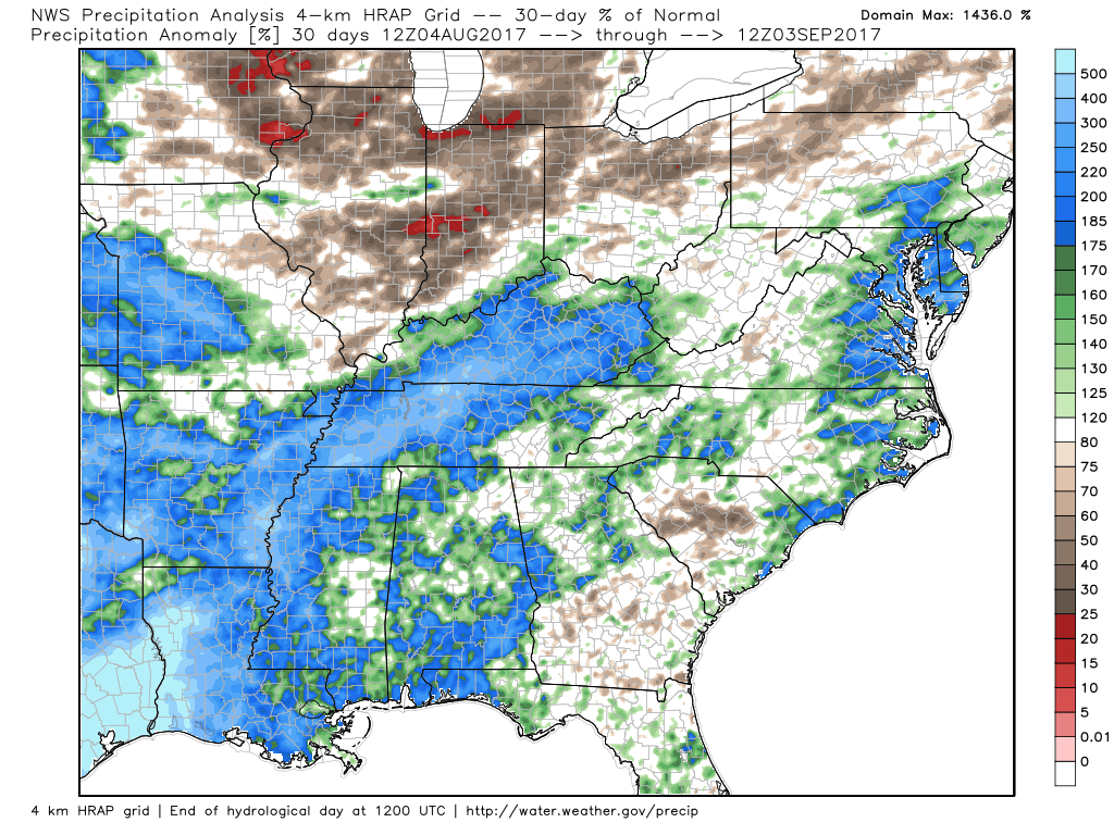
We need rain. Here is the thirty day percent of normal rainfall totals.
Click images to enlarge
Much of Illinois is drier than normal. You can see where Harvey tracked.
Another view of the 30 day % of normal. Well above normal where Harvey tracked.
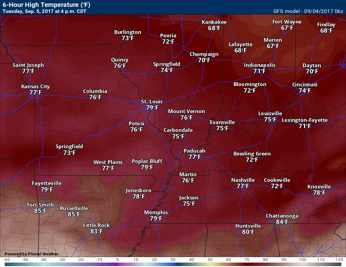
TEMPERATURE FORECAST
Low temperatures for Monday night

High temperatures for Tuesday (below)
Low temperatures for Tuesday night (below)
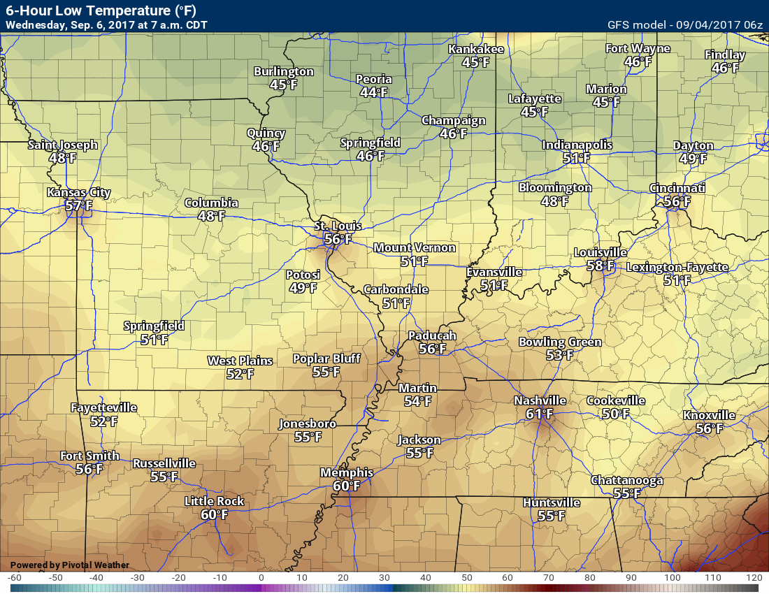
High temperatures for Wednesday (below)
Low temperatures for Wednesday night (below)
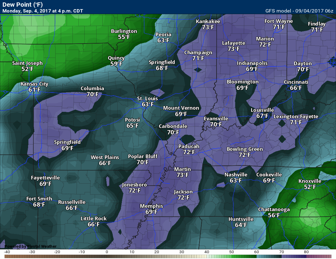
Dew point scale

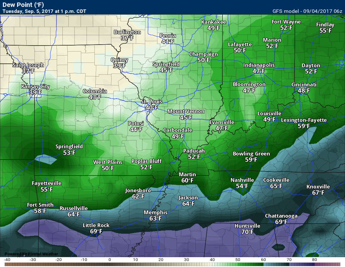
Check out Monday evening’s dew points. Humid.
Dew points for Tuesday
Nice dew points on Tuesday into the end of the week. Fallish.
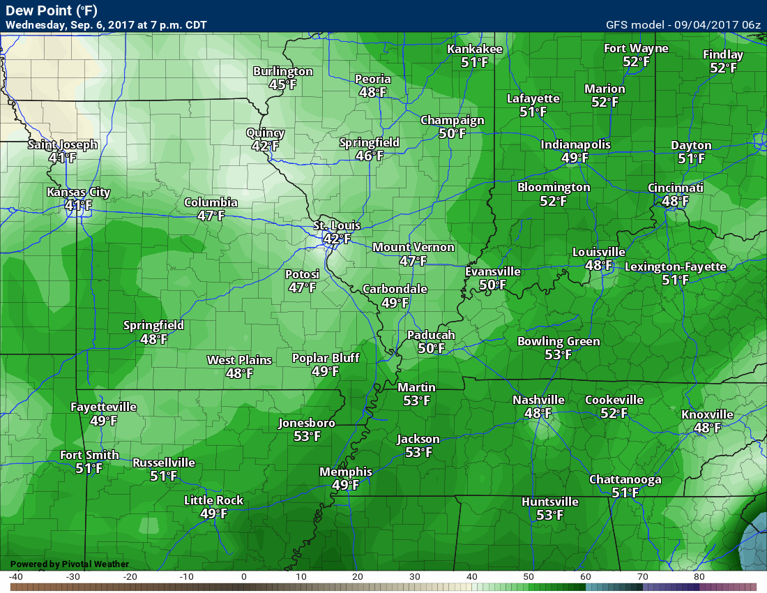
Dew points for Wednesday
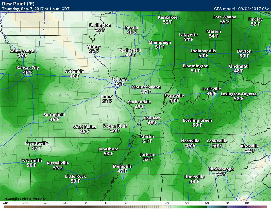
Dew points for Thursday
Long range
Confidence level is medium to high for the long range forecast.
Dry weather is anticipated on Tuesday afternoon into the weekend. Dry with pleasant temperatures.
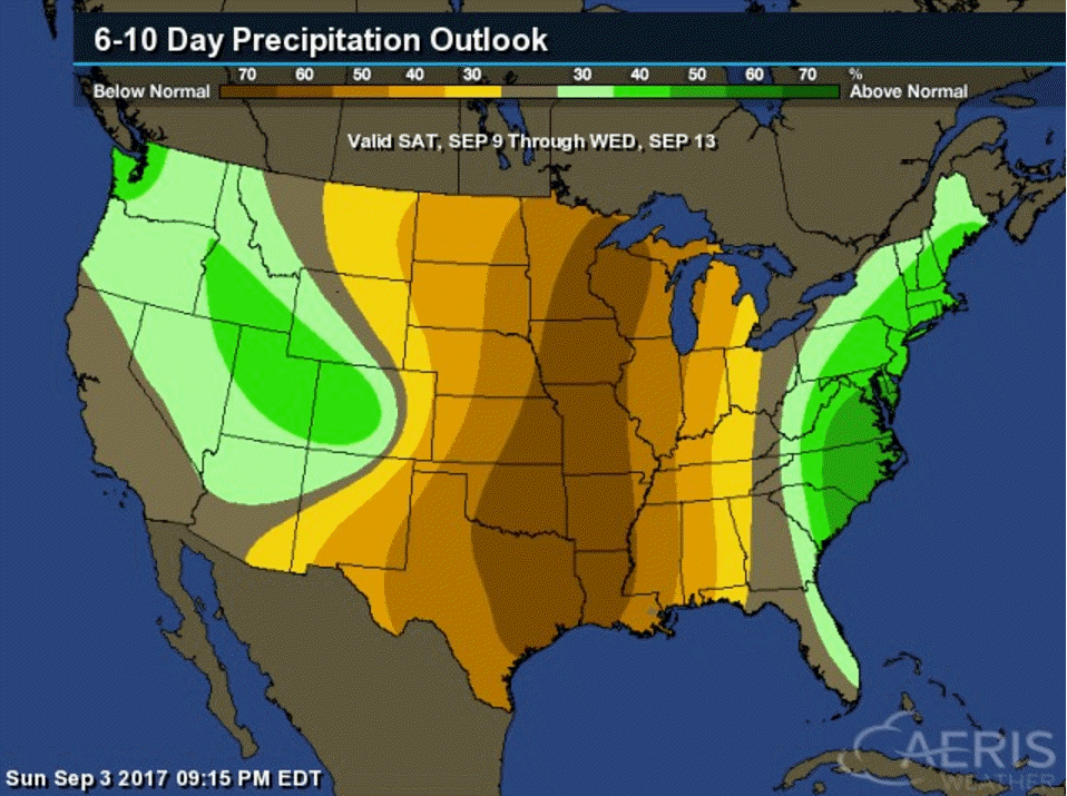
Here is the latest six to ten and eight to fourteen day temperature and precipitation outlooks
September 9th through September 13th. Odds greatly favor below normal temperatures.

September 9th through September 13th. Odds favor below normal precipitation. We will need to monitor Hurricane Irma for adjustments.
September 13th through the 17th. Odds favor normal to below normal temperatures. Much of this may hang on the eventual track of Hurricane Irma.
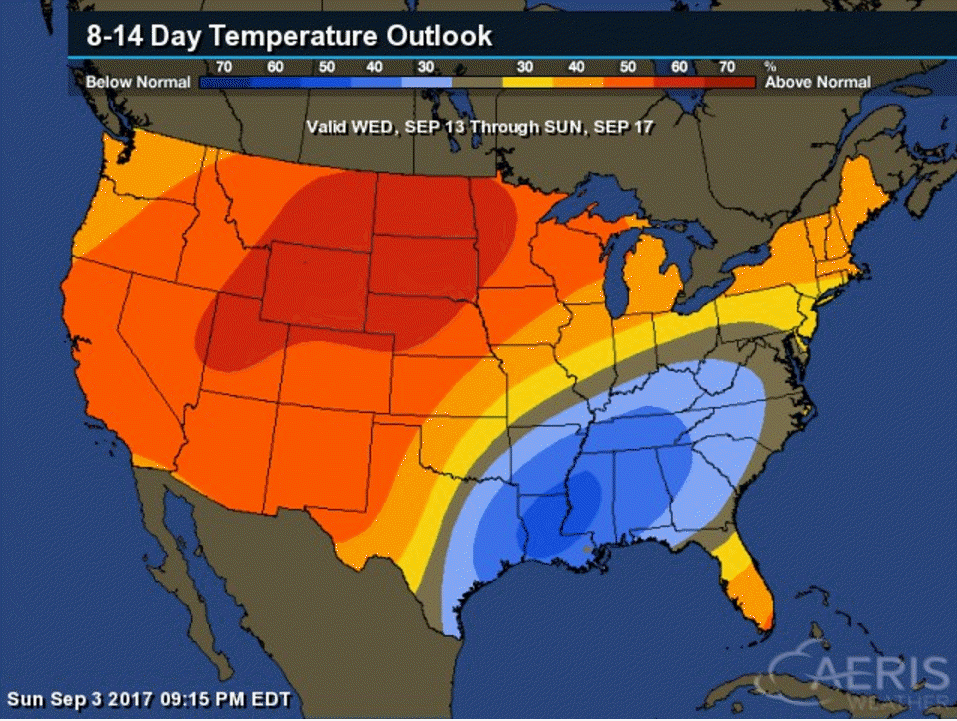
September 13th through the 17th. Odds favor below normal precipitation. The track of Hurricane Irma will greatly influence this map. Monitor updates.

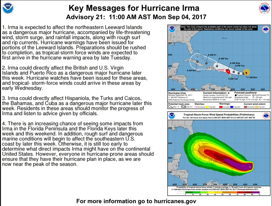
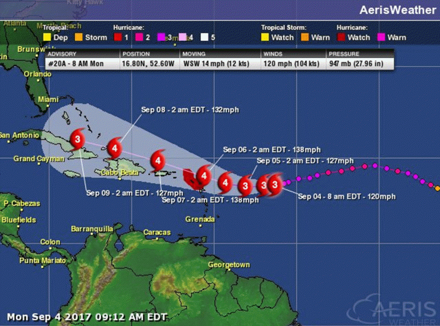
HURRICANE IRMA
I am closely monitoring Hurricane Irma. Some of the model guidance attempts to bring Irma into the Ohio Valley. We still have several days to monitor the track of Irma.
Here is the official track forecast from the National Hurricane Center
Click images to enlarge
The system continues to trend further and further south. If it rides into Cuba, then it may be torn apart. Cuba has mountains. I have watched many hurricanes be torn apart (weaken) over those mountains. Too early to know if Irma will hit Cuba or Florida. Lot of moving parts to the forecast.

.
Are you subscribing to the Weather Talk texts and videos?
We now have premiere videos for the short and long range forecasts! Make sure you have text option four turned on (green).
Sign up at www.beaudodsonweather.com
We also have an Apple and Android app (scroll down to bottom of the page for more information)

Were you aware that I have hired some help for long range videos? Short range videos, as well. An amazing team of meteorologists.
Click the link below to read more
http://cms.weathertalk.com/meet-the-team/
Weather Talk subscribers now have some of the best short and long range weather videos produced across the eastern United States.
.


We have regional radars and local city radars – if a radar does not update then try another one. Occasional browsers need their cache cleared. You may also try restarting your browser. That usually fixes the problem. Occasionally we do have a radar go down. That is why I have duplicates. Thus, if one fails then try another one.
During the winter you can track snow and ice by clicking the winterize button on the local city view interactive radars.
If you have any problems then please send me an email beaudodson@usawx.com
Interactive Weather Radar Page. Choose the city nearest your location: Click this link
National interactive radar: Click this link.
Local interactive city radars include St Louis, Mt Vernon, Evansville, Poplar Bluff, Cape Girardeau, Marion, Paducah, Hopkinsville, Memphis, Nashville, Dyersburg, and all of eastern Kentucky. These are interactive radars. Local city radars – click here
The Beau Dodson Weather APP is ready for Apple and Android users. The purpose of this app is for me to deliver your app/text messages instantly. ATT and Verizon have not always been reliable when it comes to speed. The app allows instant delivery.
Some of you have asked if you can receive the texts on your phone and the app. The answer to that is, yes. The Android app will automatically allow that to happen. On the Apple app, however, you will need to go into your app and click settings. Make sure the green tab is OFF. Off means you will still receive the texts to your phone and the app. If you have any questions, then email me at beaudodson@usawx.com
The app is for text subscribers.
The direct download, for the Apple app, can be viewed here
https://itunes.apple.com/us/app/id1190136514
If you have not signed up for the texting service then you may do so at www.beaudodsonweather.com

The Android app is also ready.
Remember, the app’s are for www.weathertalk.com subscribers. The app allows your to receive the text messages faster than ATT and Verizon.
Here is the download link for the Android version Click Here

——————————————————–
If you have not signed up for the texts messages, then please do. Link www.beaudodsonweather.com
Your support helps with the following:

and


Who do you trust for your weather information and who holds them accountable?
I have studied weather in our region since the late 1970’s. I have 39 years of experience in observing our regions weather patterns. My degree is in Broadcast Meteorology and a Bachelor’s of Science.
My resume includes:
Member of the American Meteorological Society.
NOAA Weather-Ready Nation Ambassador.
Meteorologist for McCracken County Emergency Management. I served from 2005 through 2015.
Meteorologist for McCracken County Rescue. 2015 through current
I own and operate the Southern Illinois Weather Observatory.
I am the chief meteorologist for Weather Talk LLC. I am the owner of Weather Talk LLC.
I am also a business owner in western Kentucky.
Recipient of the Mark Trail Award, WPSD Six Who Make A Difference Award, Kentucky Colonel, and the Caesar J. Fiamma” Award from the American Red Cross.
In 2005 I helped open the largest American Cross shelter in U.S. history in Houston, Texas. I was deployed to help after Hurricane Katrina and Hurricane Rita. I was a shelter manager of one of the Houston, Texas shelter divisions.
In 2009 I was presented with the Kentucky Office of Highway Safety Award.
Recognized by the Kentucky House of Representatives for my service to the State of Kentucky leading up to several winter storms and severe weather outbreaks.
If you click on the image below you can read the Kentucky House of Representatives Resolution.

I am also President of the Shadow Angel Foundation which serves portions of western Kentucky and southern Illinois.
There is a lot of noise on the internet. A lot of weather maps are posted without explanation. Over time you should learn who to trust for your weather information.
My forecast philosophy is simple and straight forward.
- Communicate in simple terms
- To be as accurate as possible within a reasonable time frame before an event
- Interact with you on Twitter, Facebook, email, texts, and this blog
- Minimize the “hype” that you might see on some television stations or through other weather sources
- Push you towards utilizing wall-to-wall LOCAL TV coverage during severe weather events
Many of the graphics on this page are from www.weatherbell.com
WeatherBell is a great resource for weather model guidance.


You can sign up for my AWARE email by clicking here I typically send out AWARE emails before severe weather, winter storms, or other active weather situations. I do not email watches or warnings. The emails are a basic “heads up” concerning incoming weather conditions