8 AM Facebook update
https://wtalk.co/HTQZ7VUX
Morning Update
Severe weather is not anticipated through Sunday.
Tuesday, September 26, 2017
Good day, everyone.
Weather Highlights
1. Another hot and humid day.
2. Isolated storms again possible
3. Wednesday will be warm, but the cold front will push southward through the afternoon hours.
4. Small rain chances along the front.
5. Highs in the 70’s Thursday through Sunday!
Another day of hot and humid air for the region. You can expect a repeat of Monday. Highs in the upper 80’s to around 90 degrees. Humid, as well. A couple of storms are possible in the region, but the vast majority will remain dry.
The much anticipated cold front will arrive on Wednesday. This will bring an end to this heat wave. Only small rain chances along the frontal boundary. Gusty winds near the front, as well.
Nice weekend ahead of us! I hope you can enjoy it.


.
A Weather Talk subscription ($3 a month) is required to view the videos.
Videos are posted on the www.weathertalk.com website. Once there, click the Beau Video-Cast tab. Long Range Video Update
If you believe you missed a video then you may check the LIVE FEED link on the Weather Talk website. You will find an archive of videos on that page.
You can also receive the videos via your Weather Talk app/text messages. Have text option FOUR activated. The Weather Extra text option. Sign up for the app/text messages, videos, and more at www.beaudodsonweather.com
.

.
This forecast update covers southern Illinois, southeast Missouri, western Kentucky. and extreme northwest Tennessee.
.
September 25, 2017
Monday Night Forecast Details:
Forecast: Evening clouds giving way to clear sky conditions. Patchy fog. Mild. A slight chance for an evening thunderstorm.
Temperatures: MO ~ 64 to 68 IL ~ 64 to 68 KY ~ 64 to 68 TN ~ 64 to 68
Winds: South at 3 to 6 mph
What impacts are anticipated from the weather? Slight chance for evening wet roadways and lightning. Lower visibility if fog forms.
My confidence in the forecast verifying: High
Is severe weather expected? No
The NWS defines severe weather as 58 mph winds or great, 1″ hail or larger, and/or tornadoes
What is the chance of precipitation? MO ~ 10% IL ~ 10% KY ~ 20% TN ~ 10%
Coverage of precipitation: None to isolated.
Should I cancel my outdoor plans? No, but check radars.
.
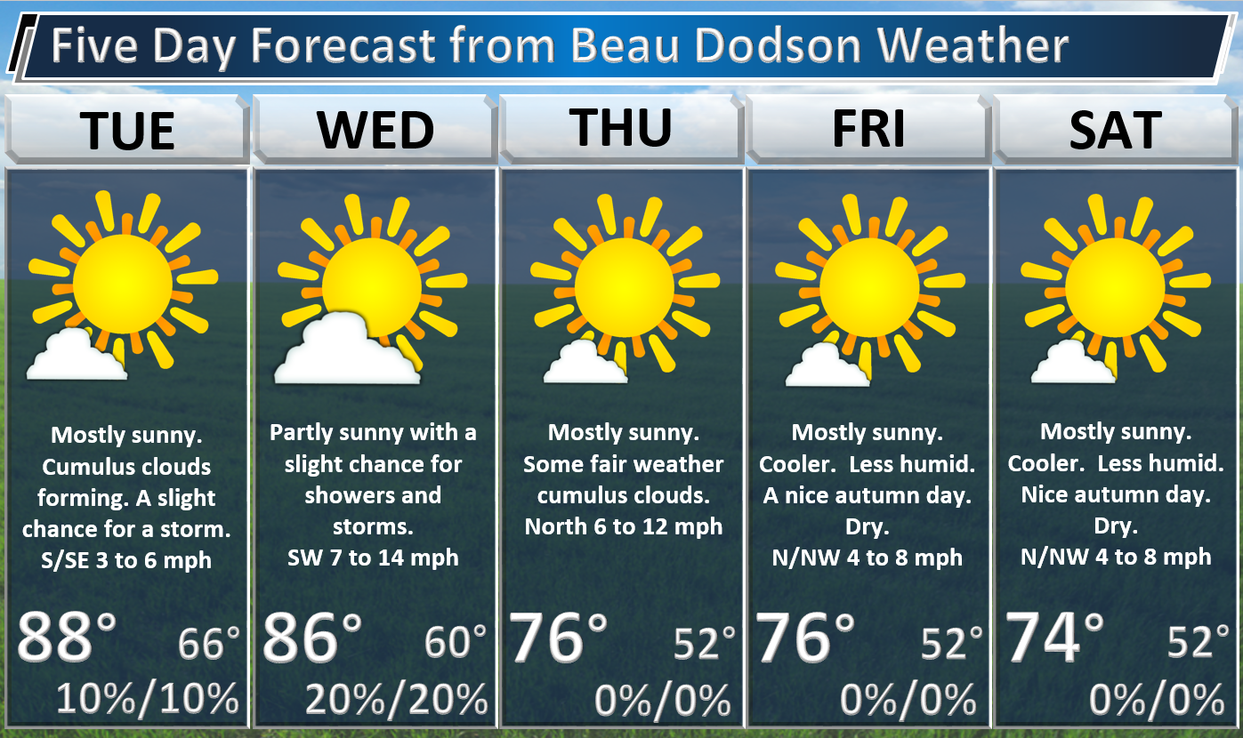
September 26, 2017
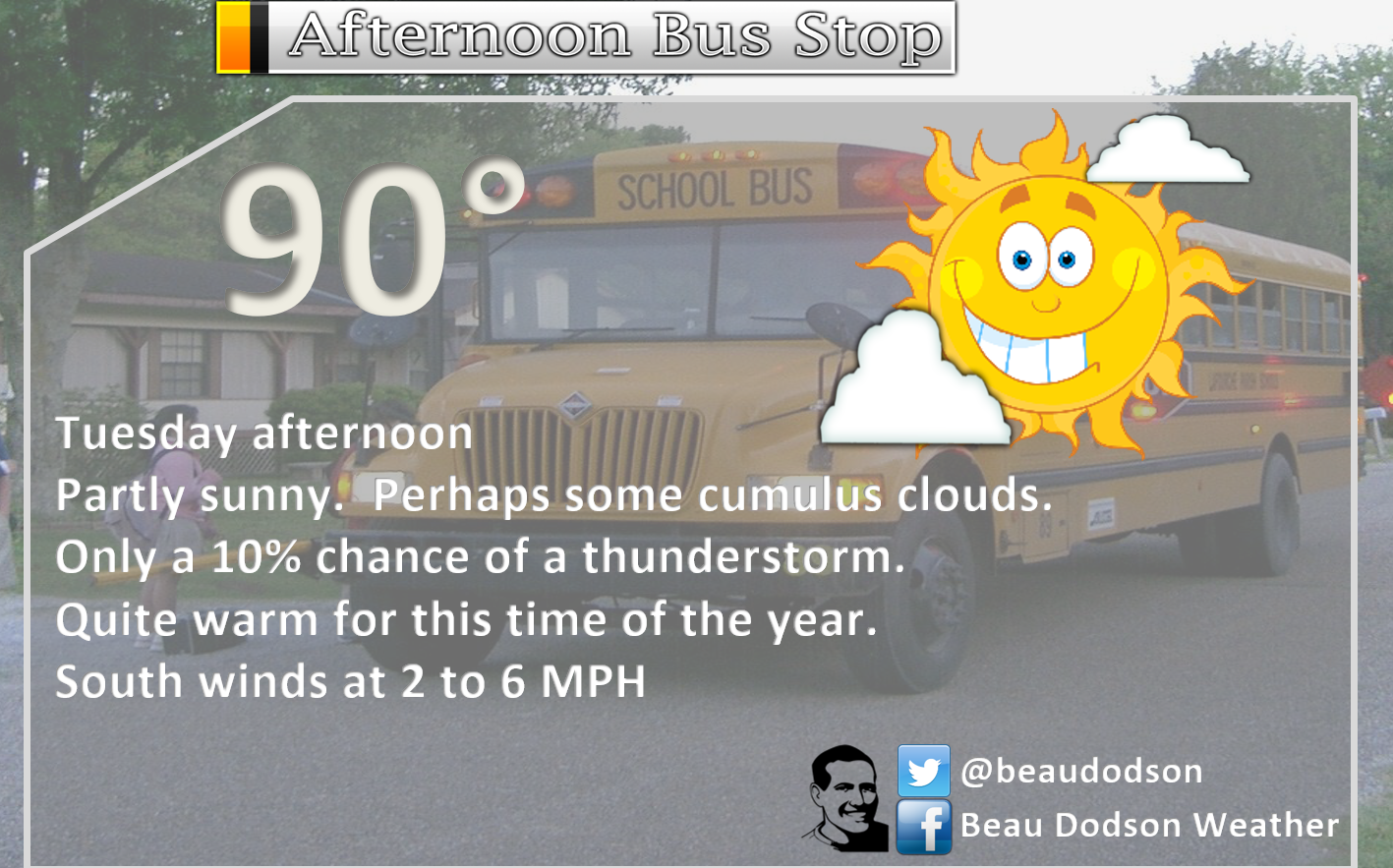
Tuesday Forecast Details
Forecast: Mostly sunny. Some cumulus clouds. Warm and humid. Only a 10% for a thunderstorm.
Temperatures: MO ~ 86 to 92 IL ~ 86 to 92 KY ~ 86 to 92 TN ~ 86 to 92
Winds: South and southeast at 0 to 5 mph
What impacts are anticipated from the weather? Most likely none. Isolated chance for wet roadways and lightning.
My confidence in the forecast verifying: High
Is severe weather expected? No
The NWS defines severe weather as 58 mph winds or great, 1″ hail or larger, and/or tornadoes
What is the chance of precipitation? MO ~ 10% IL ~ 10% KY ~ 10% TN ~ 10%
Coverage of precipitation: None to isolated
Should I cancel my outdoor plans? No
.
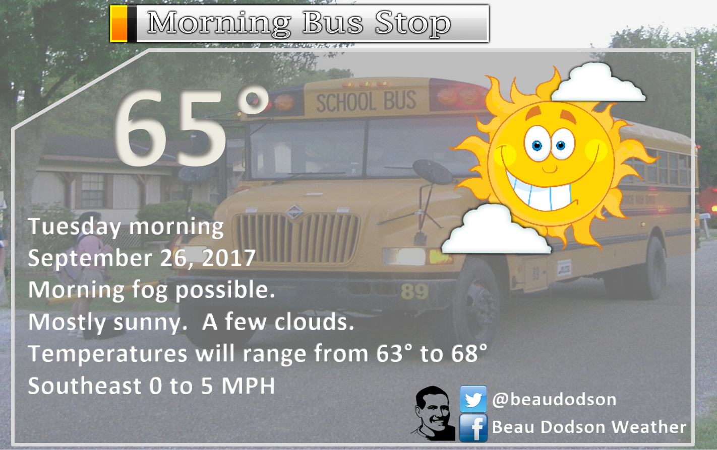
Tuesday Night Forecast Details:
Forecast: Partly cloudy. Patchy fog. Mild.
Temperatures: MO ~ 63 to 66 IL ~ 63 to 66 KY ~ 63 to 66 TN ~ 63 to 66
Winds: South at 0 to 6 mph
What impacts are anticipated from the weather? Slight chance wet roadways and lightning. Lower visibility if fog forms.
My confidence in the forecast verifying: High
Is severe weather expected? No
The NWS defines severe weather as 58 mph winds or great, 1″ hail or larger, and/or tornadoes
What is the chance of precipitation? MO ~ 10% IL ~ 10% KY ~ 10% TN ~ 10%
Coverage of precipitation: None to isolated.
Should I cancel my outdoor plans? No
.
September 27, 2017
Wednesday Forecast Details
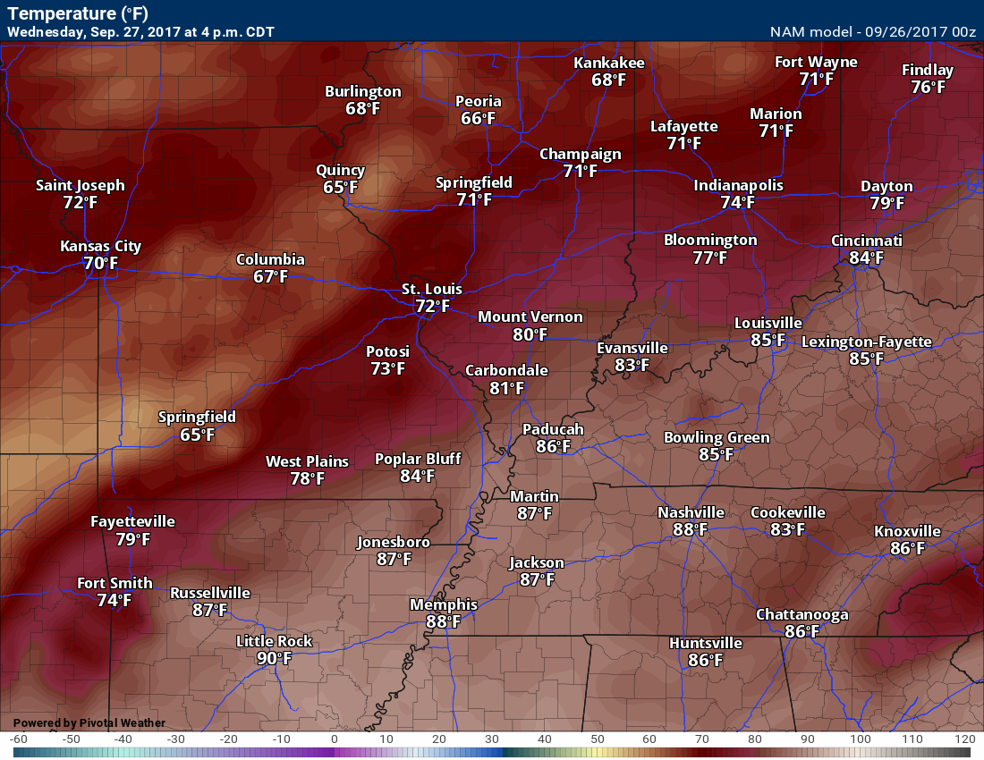
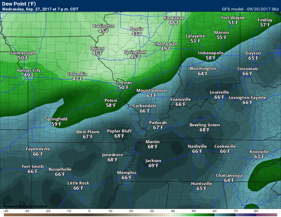
Forecast: Partly sunny. Warm and humid ahead of the front. A 20% for showers and thunderstorms. Temperatures may fall late in the day. This will depend on the speed of the cold front.
Temperatures: MO ~ 78 to 84 IL ~78 to 84 KY ~ 78 to 84 TN ~ 78 to 84
Winds: Southwest winds becoming northwest at 8 to 14 mph. Winds could be gusty along the cold front.
What impacts are anticipated from the weather? Isolated wet roadways. Isolated lightning.
My confidence in the forecast verifying: Medium
Is severe weather expected? No
The NWS defines severe weather as 58 mph winds or great, 1″ hail or larger, and/or tornadoes
What is the chance of precipitation? MO ~ 20% IL ~ 20% KY ~ 20% TN ~ 20%
Coverage of precipitation: Isolated.
Should I cancel my outdoor plans? Not at this time
.
Wednesday Night Forecast Details:
Forecast: Partly cloudy. A slight chance for an evening shower over western Kentucky and the Missouri Bootheel.
Temperatures: MO ~ 58 to 64 IL ~ 58 to 64 KY ~ 58 to 64 TN ~ 58 to 64
Winds: North at 6 to 12 mph. Gusts to 16 mph before midnight.
What impacts are anticipated from the weather? Most likely none.
My confidence in the forecast verifying: Medium
Is severe weather expected? No
The NWS defines severe weather as 58 mph winds or great, 1″ hail or larger, and/or tornadoes
What is the chance of precipitation? MO ~ 10% IL ~ 10% KY ~ 10% TN ~ 10%
Coverage of precipitation: Isolated.
Should I cancel my outdoor plans? No
.
September 28, 2017
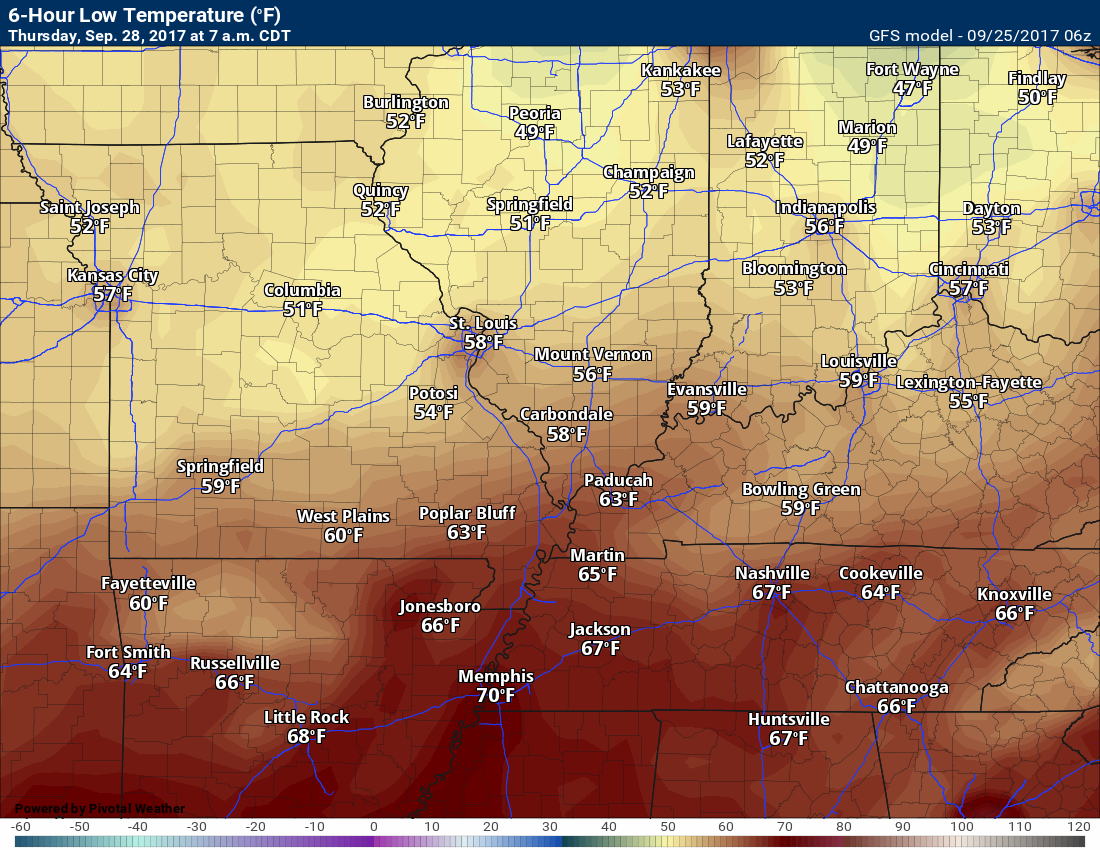
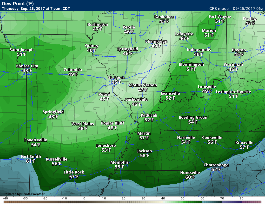
Thursday Forecast Details
Forecast: Mostly sunny. Cooler. Some afternoon fair weather cumulus clouds possible.
Temperatures: MO ~ 74 to 78 IL ~74 to 78 KY ~ 74 to 78 TN ~ 74 to 78
Winds: Northerly at 6 to 12 mph
What impacts are anticipated from the weather? None
My confidence in the forecast verifying: Medium
Is severe weather expected? No
The NWS defines severe weather as 58 mph winds or great, 1″ hail or larger, and/or tornadoes
What is the chance of precipitation? MO ~ 0% IL ~ 0% KY ~ 0% TN ~ 0%
Coverage of precipitation: None
Should I cancel my outdoor plans? Not at this time
.
Thursday Night Forecast Details:
Forecast: Some evening clouds. Becoming mostly clear and cooler.
Temperatures: MO ~ 50 to 55 IL ~ 50 to 55 KY ~ 50 to 55 TN ~ 50 to 55
Winds: North at 5 to 10 mph
What impacts are anticipated from the weather? None
My confidence in the forecast verifying: Medium
Is severe weather expected? No
The NWS defines severe weather as 58 mph winds or great, 1″ hail or larger, and/or tornadoes
What is the chance of precipitation? MO ~ 0% IL ~ 0% KY ~ 0% TN ~ 0%
Coverage of precipitation: None
Should I cancel my outdoor plans? No
.
September 29, 2017
Friday Forecast Details
Forecast: Mostly sunny. Cooler. Some afternoon fair weather cumulus clouds possible.
Temperatures: MO ~ 74 to 78 IL ~ 74 to 78 KY ~ 74 to 78 TN ~ 74 to 78
Winds: Northerly at 6 to 12 mph
What impacts are anticipated from the weather? None
My confidence in the forecast verifying: Medium
Is severe weather expected? No
The NWS defines severe weather as 58 mph winds or great, 1″ hail or larger, and/or tornadoes
What is the chance of precipitation? MO ~ 0% IL ~ 0% KY ~ 0% TN ~ 0%
Coverage of precipitation: None
Should I cancel my outdoor plans? Not at this time
.
Friday Night Forecast Details:
Forecast: Mostly clear. Cooler.
Temperatures: MO ~ 48 to 54 IL ~ 48 to 54 KY ~ 48 to 54 TN ~ 48 to 54
Winds: North and northeast at 4 to 8 mph
What impacts are anticipated from the weather? None
My confidence in the forecast verifying: Medium
Is severe weather expected? No
The NWS defines severe weather as 58 mph winds or great, 1″ hail or larger, and/or tornadoes
What is the chance of precipitation? MO ~ 0% IL ~ 0% KY ~ 0% TN ~ 0%
Coverage of precipitation: None
Should I cancel my outdoor plans? No
.
September 30, 2017
Saturday Forecast Details
Forecast: Mostly sunny. Cooler. Some afternoon fair weather cumulus clouds possible.
Temperatures: MO ~ 68 to 74 IL ~68 to 74 KY ~ 68 to 74 TN ~ 70 to 75
Winds: North and northeast at 4 to 8 mph
What impacts are anticipated from the weather? None
My confidence in the forecast verifying: Medium
Is severe weather expected? No
The NWS defines severe weather as 58 mph winds or great, 1″ hail or larger, and/or tornadoes
What is the chance of precipitation? MO ~ 0% IL ~ 0% KY ~ 0% TN ~ 0%
Coverage of precipitation: None
Should I cancel my outdoor plans? Not at this time
.
Saturday Night Forecast Details:
Forecast: Mostly clear. Cool.
Temperatures: MO ~ 48 to 54 IL ~ 48 to 54 KY ~ 48 to 54 TN ~ 48 to 54
Winds: North and northeast at 0 to 5 mph
What impacts are anticipated from the weather? None
My confidence in the forecast verifying: Medium
Is severe weather expected? No
The NWS defines severe weather as 58 mph winds or great, 1″ hail or larger, and/or tornadoes
What is the chance of precipitation? MO ~ 0% IL ~ 0% KY ~ 0% TN ~ 0%
Coverage of precipitation: None
Should I cancel my outdoor plans? No
.
October 1, 2017
Sunday Forecast Details
Forecast: Mostly sunny. Some afternoon fair weather cumulus clouds possible.
Temperatures: MO ~ 72 to 76 IL ~72 to 76 KY ~ 72 to 76 TN ~ 72 to 76
Winds: Easterly at 4 to 8 mph
What impacts are anticipated from the weather? None
My confidence in the forecast verifying: Medium
Is severe weather expected? No
The NWS defines severe weather as 58 mph winds or great, 1″ hail or larger, and/or tornadoes
What is the chance of precipitation? MO ~ 0% IL ~ 0% KY ~ 0% TN ~ 0%
Coverage of precipitation: None
Should I cancel my outdoor plans? Not at this time
.
Sunday Night Forecast Details:
Forecast: A few passing clouds. Cool.
Temperatures: MO ~ 52 to 56 IL ~ 52 to 56 KY ~ 52 to 56 TN ~ 52 to 56
Winds: Southeast at 0 to 5 mph
What impacts are anticipated from the weather? None
My confidence in the forecast verifying: Medium
Is severe weather expected? No
The NWS defines severe weather as 58 mph winds or great, 1″ hail or larger, and/or tornadoes
What is the chance of precipitation? MO ~ 0% IL ~ 0% KY ~ 0% TN ~ 0%
Coverage of precipitation: None
Should I cancel my outdoor plans? No
.
October 2, 2017
Monday Forecast Details
Forecast: Partly sunny. Mild.
Temperatures: MO ~ 76 to 82 IL ~76 to 82 KY ~ 76 to 82 TN ~ 76 to 82
Winds: South at 5 to 10 mph
What impacts are anticipated from the weather? None
My confidence in the forecast verifying: Medium
Is severe weather expected? No
The NWS defines severe weather as 58 mph winds or great, 1″ hail or larger, and/or tornadoes
What is the chance of precipitation? MO ~ 10% IL ~ 10% KY ~ 10% TN ~ 10%
Coverage of precipitation: Most likely none
Should I cancel my outdoor plans? Not at this time
.
Monday Night Forecast Details:
Forecast: Partly cloudy. Not as cool.
Temperatures: MO ~ 58 to 64 IL ~ 58 to 64 KY ~ 58 to 64 TN ~ 58 to 64
Winds: South at 0 to 5 mph
What impacts are anticipated from the weather? None
My confidence in the forecast verifying: Medium
Is severe weather expected? No
The NWS defines severe weather as 58 mph winds or great, 1″ hail or larger, and/or tornadoes
What is the chance of precipitation? MO ~ 0% IL ~ 0% KY ~ 0% TN ~ 0%
Coverage of precipitation: None
Should I cancel my outdoor plans? No
WILD swings in the model for next week. Some of the guidance is showing 50’s and rain. Some of the guidance is showing 90’s and sun. Needless to say, I will be looking a bit deeper into next weeks forecast.
.
.
.

The National Weather Service definition of a severe thunderstorm is one that produces quarter size hail or larger, 58 mph winds or greater, and/or a tornado.
Monday night through Sunday: Severe weather is not anticipated. A few isolated thunderstorms are possible through Wednesday. Most of the area will remain dry. A few spots could pick up locally heavy rain. That will be the exception and not the rule.
If storms form, then they could produce locally heavy rain, gusty winds, and dime to nickel size hail. The risk for severe weather is minimal.
.

Overview
Highlights of the forecast.
- Hot and humid weather into Tuesday.
- A cold front arrives mid-week. Much cooler air. Less humid.
- Drought to worsen over portions of the region.
- Heat next week or cool next week?
Short range comments
Subscribers, sign into your WeatherTalk account and see the latest October forecast. Click here for that information.
(See the long range discussion further down in this post)
Relief is finally in sight. I saw relief, some of you like this hot weather! So, the forecast won’t make those people happy.
Temperatures have been well above normal for over a week. That is about to end.
Temperatures will top out in the 70’s Thursday through Monday. This will be more seasonal. Normal high temperatures are in the upper 70’s.
We might experience lows in the upper 40’s and lower 50’s Thursday, Friday, Saturday, and Sunday night.
Rain chances will be slim. Perhaps not zero, but not far off. I am watching a cut-off low in the long range (see that discussion further down in this blog update).
The cold front, on Wednesday, will likely not produce widespread showers and thunderstorms. Portions of our region are nearing drought conditions.
Temperature Forecast
Monday night low temperatures
Tuesday high temperatures

Tuesday night low temperatures

Wednesday high temperatures
Thursday low temperatures
Dew point scale
Dew points are what control how you feel outside.

Tuesday dew point temperatures

Wednesday dew point temperatures
Thursday dew point temperatures
Lower dew points will mean a nicer feel to the atmosphere.
Friday dew point temperatures
Autumn dew points! Nicer.

Long range forecast discussion
This discussion covers Thursday through next Wednesday.
MAJOR differences in opinion among different guidance packages for next week.
Another heat wave? Chilly and rain? Models show both.
The vast majority of guidance is showing the heat ridge attempting to build back into the region. If this happens, then we will return to hot and muggy weather. hard to believe, I know. It was be quite unusual to have two significant heat streaks in late September and early October.
The best hope for rain, at least for next week, will be from a possible cut-off low. Lower than normal confidence in this happening. A cut-off low is a low that is cut off form the jet stream. They can move slowly and meander. If this happens then clouds and rain would be worse us for at least a portion of next week. Again, not overly confident that this happens.
The EC guidance shows the low. You can see the blue. That indicates low than normal heights/lower than normal temperatures. Other guidance is not picking up on this feature. That does not add to the confidence level of the forecast.
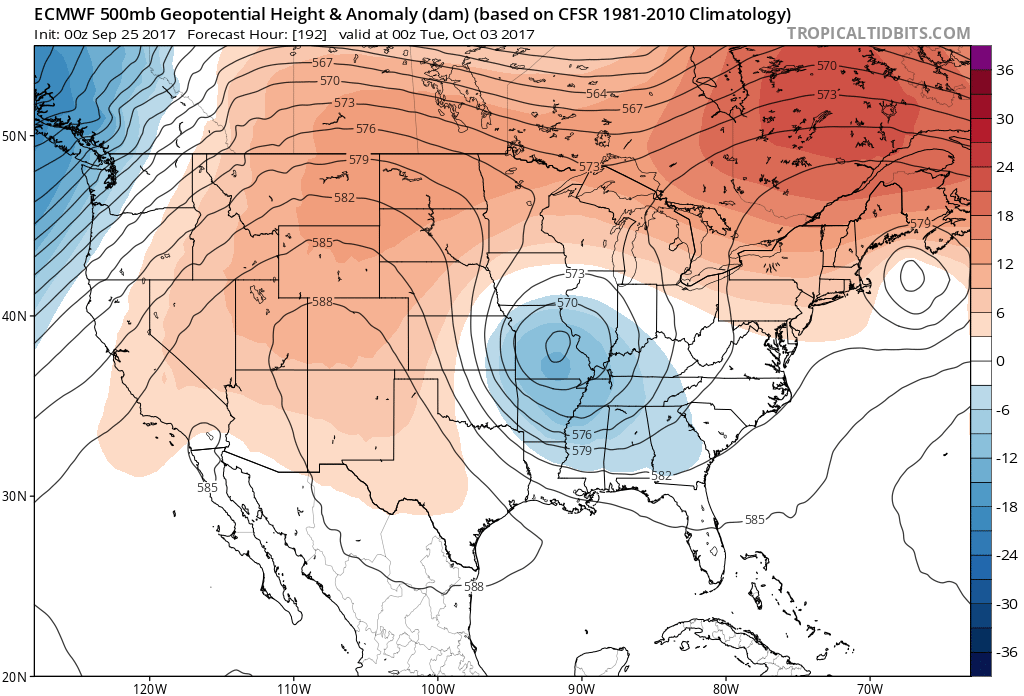
On the other hand, other guidance is showing hot and humid weather.
This next graphic is the same model. It is just the new run of that model. What in the world. It is completely opposite of the last run.
That tells me you can’t trust the guidance on next week weather.
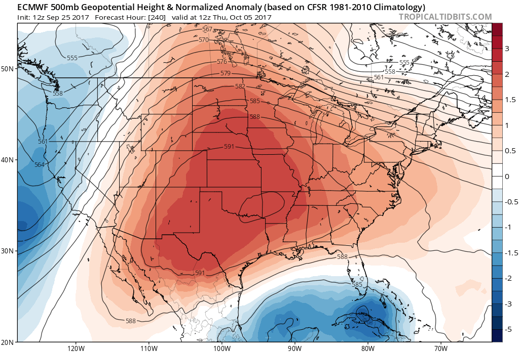
Right now, I am leaning towards the ridge building back into the region. The strength of the ridge will decide temperatures. Strong ridge would mean a return to upper 80’s. A weaker ridge would mean upper 70’s to middle 80’s.
Overall, the long range forecast is indicating high probabilities for below normal precipitation during the month of October. I have been watching a front for Sunday night/Monday, but right now that does not look all that impressive.
Next week is shaping up to be mostly dry, as well. Widespread moderate or heavy rain is not in the cards. For that matter, light rain, either.
.
.
Are you subscribing to Weather Talk app/text messages and videos? This is what helps support all of the data you see each day.
We now offer premium videos for the short and long range forecasts! These videos are produced by a team of long range forecast experts. They are brought to you as bonus information. Activate text option four in order to receive these on your app or via text.
Subscribe at www.beaudodsonweather.com
We offer an Apple and Android app (scroll to the bottom of this page for more information).

Were you aware that I hired a team of meteorologists for long range videos?
To learn more, click this link
http://cms.weathertalk.com/meet-the-team/
.


We offer regional radars and local city radars – if a radar does not update then try another one. Occasional browsers need their cache cleared. You may also try restarting your browser. This will usually fix any problems.
During the winter you can track snow and ice by clicking the winterize button on the local city view interactive radars.
You may email me at beaudodson@usawx.com
Interactive Weather Radar Page. Choose the city nearest your location: Click this link
National interactive radar: Click this link.
The Beau Dodson Weather APP is ready for Apple and Android users. The app provides a faster way for you to receive my text messages. ATT and Verizon are not always reliable when it comes to speed.
Some of you have asked if you can receive the texts on your phone and the app. The answer to that is, yes. The Android app will automatically allow that to happen. On the Apple app, however, you will need to open your app and click the settings button. Make sure the green tab is OFF. Off means you will still receive the texts to your phone and the app. If you have any questions, then email me at beaudodson@usawx.com
The app is for text subscribers.
The direct download, for the Apple app, can be viewed here
https://itunes.apple.com/us/app/id1190136514
Here is the download link for the Android version Click Here
If you have not signed up for the texting service then you may do so at www.beaudodsonweather.com


——————————————————–
Your support helps with the following:

and

.

Whom do you trust for your weather information?
I have studied weather, in our region, since the late 1970’s. I have 40 years of experience in observing our regions weather patterns. My degree is in Broadcast Meteorology and a Bachelor’s of Science.
My resume includes:
Member of the American Meteorological Society.
NOAA Weather-Ready Nation Ambassador.
Meteorologist for McCracken County Emergency Management. I served from 2005 through 2015.
Meteorologist for McCracken County Rescue. 2015 through current
I own and operate the Southern Illinois Weather Observatory.
I am the chief meteorologist for Weather Talk LLC.
I am also a business owner in western Kentucky.
Recipient of the Mark Trail Award, WPSD Six Who Make A Difference Award, Kentucky Colonel, and the Caesar J. Fiamma” Award from the American Red Cross.
In 2005, I helped open the largest American Cross shelter in U.S. history. This was in Houston, Texas. I was deployed to help with the aftermath of Hurricane Katrina and Hurricane Rita. I was a shelter manager of one of the Houston, Texas shelter divisions.
In 2009 I was presented with the Kentucky Office of Highway Safety Award.
Recognized by the Kentucky House of Representatives for my service to the State of Kentucky leading up to several winter storms and severe weather outbreaks.
If you click on the image below you can read the Kentucky House of Representatives Resolution.

I am President of the Shadow Angel Foundation which serves portions of western Kentucky and southern Illinois.
There is a lot of noise on the internet. A lot of weather maps are posted without explanation. You need a trusted source for information.
My forecast philosophy is simple and straight forward.
- Communicate in simple terms
- To be as accurate as possible within a reasonable time frame before an event
- Interact with you on Twitter, Facebook, email, texts, and this blog
- Minimize the “hype” that you might see through other weather sources
- Push you towards utilizing wall-to-wall LOCAL TV coverage during severe weather events

Sign up for my AWARE email by clicking here.
I typically send AWARE emails before severe weather, winter storms, or other active weather situations. I do not email watches or warnings. The emails are a basic “heads up” concerning incoming weather conditions