Morning update
September 19, 2017
I travel to California for a meteorology conference and nature decides to act up. A few hail events last night and now an earthquake.
Forecast
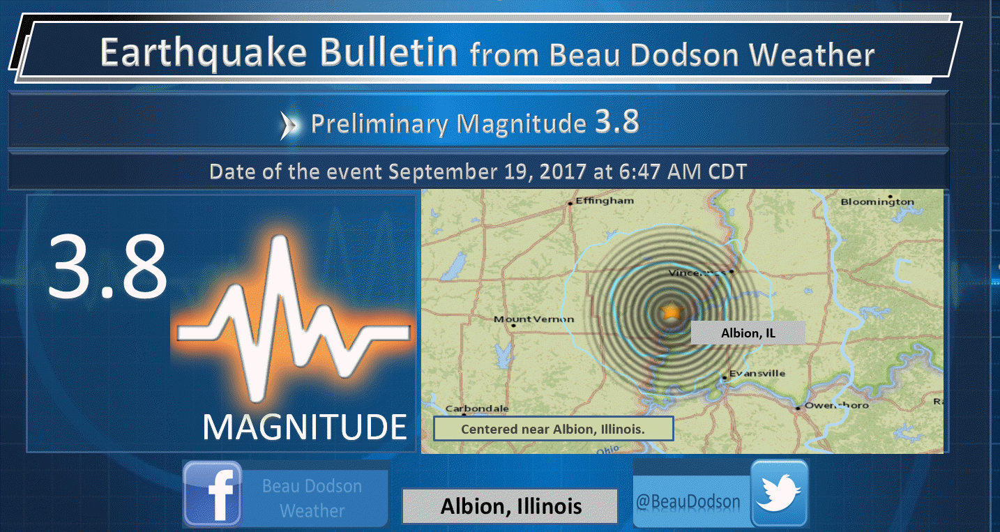
A 3.8 magnitude (preliminary) earthquake shook southeast Illinois this morning. It was centered near Albion, Illinois. See the graphic in the comment section of this post.
Portions of the region experienced thunderstorms last night. There were even a few reports of hail in Cape Girardeau County, Missouri and Jackson County, Illinois. No wind damage was reported. There was also plenty of lightning.
Storms blew up along a weak shortwave that moved through the area. There was just enough instability to cause some problems.
Today and tonight
Additional thunderstorms are either ongoing, as I type this, or will develop in the heat of the day.
There will be a low end risk for a severe thunderstorm today. Hail would be the main concern and downburst winds. Many areas will remain dry.
The greatest risk will be over western Kentucky. That will be highly dependent on the atmosphere becoming unstable (once the current storms exit).
We need rain. Most of Illinois is in a low end drought. Portions of Missouri, as well.
It is also dry over portions of western Kentucky.
Some locations picked up one to two inches of rain on Monday.
Patchy fog is possible tonight.
Wednesday through Sunday
Warm temperatures with isolated thunderstorm chances are anticipated. There are not any signals for widespread precipitation.
I am watching a stronger cold front for next week, but that is too far out for details.
Above normal temperatures will continue into at least Monday.
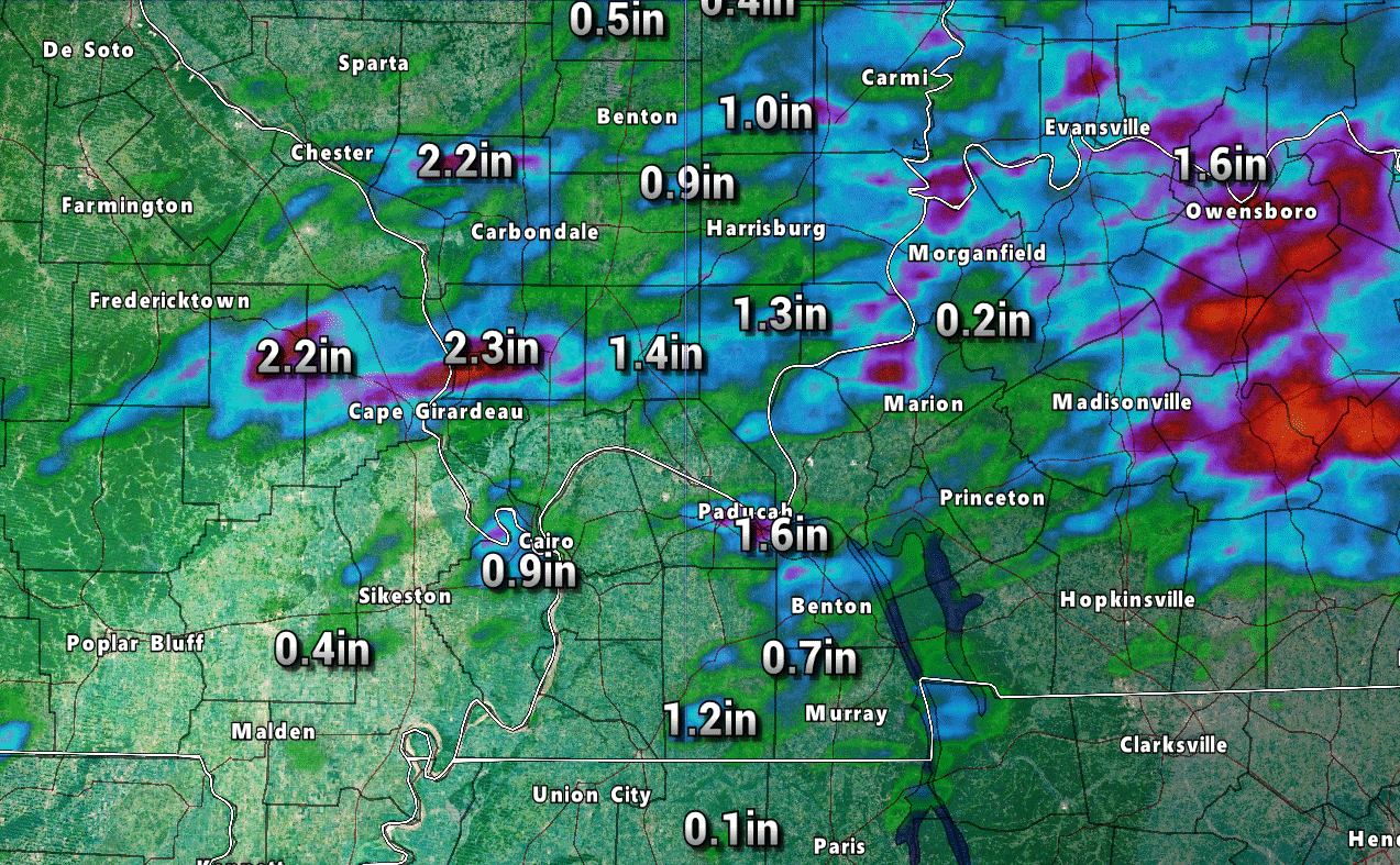
Here are some rainfall totals from the last 24 hours. Some locations pick up quite a bit of rain. Many areas remained dry
Some of the higher number in Bollinger and Cape Girardeau counties could be because of hail. That can mess up the radar estimates. Same for Union County, Illinois.
.
There was an earthquake earlier today. It shook portions of Illinois, Indiana, and Kentucky. It was assigned a preliminary magnitude of 3.8
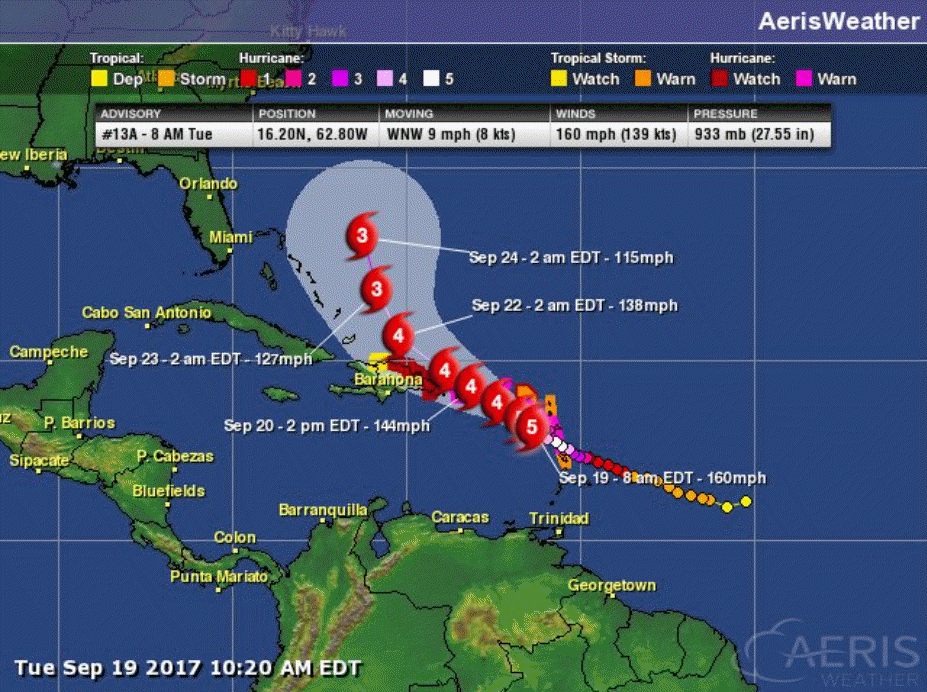
I am monitoring Hurricane Maria. At this time, it appears that it will not impact our region.
Interactive Weather Radar Page. Choose the city nearest your location: Click this link

.
A Weather Talk subscription ($3 a month) is required to view the videos.
Videos are posted on the www.weathertalk.com website. Once there, click the Beau Video-Cast tab. Long Range Video Update
If you believe you missed a video then you may check the LIVE FEED link on the Weather Talk website. You will find an archive of videos on that page.
You can also receive the videos via your Weather Talk app/text messages. Have text option FOUR activated. The Weather Extra text option. Sign up for the app/text messages, videos, and more at www.beaudodsonweather.com
.

.
This forecast update covers southern Illinois, southeast Missouri, western Kentucky. and extreme northwest Tennessee.
.
September 18, 2017
Monday Night Forecast Details:
Forecast: Partly cloudy. A chance of evening thunderstorms. Some storms could produce hail. A band of storms may move across northern parts of southern Illinois late tonight into the morning hours.
Temperatures: MO ~ 65 to 70 IL ~ 65 to 70 KY ~ 65 to 70 TN ~ 65 to 70
What impacts are anticipated from the weather? Wet roadways. Lightning. Isolated hail reports.
My confidence in the forecast verifying: High
Is severe weather expected? Isolated severe threat.
The NWS defines severe weather as 58 mph winds or great, 1″ hail or larger, and/or tornadoes
What is the chance of precipitation? MO ~ 40% IL ~ 50% KY ~ 40% TN ~ 30%
Coverage of precipitation: Isolated to widely scattered for much of the area. Perhaps more widespread over northern parts of southern Illinois late tonight.
Should I cancel my outdoor plans? No
.
September 19, 2017
Tuesday Forecast Details
Forecast: Partly sunny. Warm and humid. Widely scattered thunderstorms.
Temperatures: MO ~ 85 to 88 IL ~ 85 to 88 KY ~ 85 to 88 TN ~ 85 to 88
Winds: Calm to south winds at 5 to 10 mph
What impacts are anticipated from the weather? A chance of wet roadways and lightning.
My confidence in the forecast verifying: High
Is severe weather expected? Unlikely. A few storms could produce small hail and gusty winds.
The NWS defines severe weather as 58 mph winds or great, 1″ hail or larger, and/or tornadoes
What is the chance of precipitation? MO ~ 40% IL ~ 40% KY ~ 40% TN ~ 40%
Coverage of precipitation: Widely scattered
Should I cancel my outdoor plans? No, but monitor radars
.
Tuesday Night Forecast Details:
Forecast: Partly cloudy. Warm. A slight chance of an evening thunderstorm.
Temperatures: MO ~ 65 to 70 IL ~ 65 to 70 KY ~ 65 to 70 TN ~ 65 to 70
Winds: Southeast at 4 to 8 mph
What impacts are anticipated from the weather? Wet roadways. Lightning
My confidence in the forecast verifying: High
Is severe weather expected? No
The NWS defines severe weather as 58 mph winds or great, 1″ hail or larger, and/or tornadoes
What is the chance of precipitation? MO ~ 20% IL ~ 20% KY ~ 20% TN ~ 20%
Coverage of precipitation: None to isolated
Should I cancel my outdoor plans? No, but monitor updates
.
September 20, 2017
Wednesday Forecast Details
Forecast: Partly to mostly sunny. Warm and humid. A chance of isolated thunderstorms.
Temperatures: MO ~ 85 to 88 IL ~ 85 to 88 KY ~ 85 to 88 TN ~ 85 to 88
Winds: South and southwest winds at 5 to 10 mph
What impacts are anticipated from the weather? A chance of wet roadways and lightning.
My confidence in the forecast verifying: High
Is severe weather expected? No
The NWS defines severe weather as 58 mph winds or great, 1″ hail or larger, and/or tornadoes
What is the chance of precipitation? MO ~ 20% IL ~ 20% KY ~ 20% TN ~ 20%
Coverage of precipitation: Isolated to widely scattered
Should I cancel my outdoor plans? No, but check radars
.
Wednesday Night Forecast Details:
Forecast: A few clouds. Warm. An isolated thunderstorm possible. Patchy fog.
Temperatures: MO ~ 65 to 70 IL ~ 65 to 70 KY ~ 65 to 70 TN ~ 65 to 70
Winds: South winds at 0 to 5 mph
What impacts are anticipated from the weather? Wet roadways. Lightning. Low visibility in areas with fog.
My confidence in the forecast verifying: High
Is severe weather expected? No
The NWS defines severe weather as 58 mph winds or great, 1″ hail or larger, and/or tornadoes
What is the chance of precipitation? MO ~ 20% IL ~ 20% KY ~ 20% TN ~ 20%
Coverage of precipitation: Isolated
Should I cancel my outdoor plans? No
.
September 21, 2017
Thursday Forecast Details
Forecast: Partly sunny. Warm and humid. A chance of an afternoon thunderstorm.
Temperatures: MO ~ 85 to 90 IL ~ 85 to 90 KY ~ 85 to 90 TN ~ 85 to 90
Winds: South and southeast winds at 5 to 10 mph
What impacts are anticipated from the weather? A chance of wet roadways and lightning.
My confidence in the forecast verifying: Medium
Is severe weather expected? No
The NWS defines severe weather as 58 mph winds or great, 1″ hail or larger, and/or tornadoes
What is the chance of precipitation? MO ~ 20% IL ~ 20% KY ~ 20% TN ~ 20%
Coverage of precipitation: Widely scattered
Should I cancel my outdoor plans? No, but monitor updates
.
Thursday Night Forecast Details:
Forecast: Mostly cloudy. Warm. A slight chance of an evening thunderstorm. Patchy fog late.
Temperatures: MO ~ 65 to 70 IL ~ 65 to 70 KY ~ 65 to 70 TN ~ 65 to 70
Winds: Southeast at 4 to 8 mph
What impacts are anticipated from the weather? Wet roadways. Lightning. Low visibility in areas with fog.
My confidence in the forecast verifying: Medium
Is severe weather expected? No
The NWS defines severe weather as 58 mph winds or great, 1″ hail or larger, and/or tornadoes
What is the chance of precipitation? MO ~ 20% IL ~ 20% KY ~ 20% TN ~ 20%
Coverage of precipitation: Widely scattered
Should I cancel my outdoor plans? No, but monitor updates
.
September 22, 2017
Friday Forecast Details
Forecast: Partly sunny. Very warm for late September.
Temperatures: MO ~ 85 to 88 IL ~ 85 to 88 KY ~ 85 to 88 TN ~ 85 to 88
Winds: South at 5 to 10 mph
What impacts are anticipated from the weather? Most likely none.
My confidence in the forecast verifying: Low
Is severe weather expected? No
The NWS defines severe weather as 58 mph winds or great, 1″ hail or larger, and/or tornadoes
What is the chance of precipitation? MO ~ 20% IL ~ 20% KY ~ 20% TN ~ 20%
Coverage of precipitation: Isolated
Should I cancel my outdoor plans? No
.
Friday Night Forecast Details:
Forecast: Evening clouds giving way to clear sky conditions. Patchy fog. Mild. Isolated evening storms possible.
Temperatures: MO ~ 65 to 70 IL ~ 65 to 70 KY ~ 65 to 70 TN ~ 65 to 70
Winds: Southeast at 4 to 8 mph
What impacts are anticipated from the weather? Slight chance for evening wet roadways and lightning. Lower visibility if fog forms
My confidence in the forecast verifying: Medium
Is severe weather expected? No
The NWS defines severe weather as 58 mph winds or great, 1″ hail or larger, and/or tornadoes
What is the chance of precipitation? MO ~ 10% IL ~ 10% KY ~ 10% TN ~ 10%
Coverage of precipitation: None to isolated.
Should I cancel my outdoor plans? No
.
September 23, 2017
Saturday Forecast Details
Forecast: Partly sunny. Very warm for late September. A slight chance of a thunderstorm.
Temperatures: MO ~ 85 to 88 IL ~ 85 to 88 KY ~ 85 to 88 TN ~ 85 to 88
Winds: Southeast at 4 to 8 mph
What impacts are anticipated from the weather? Wet roadways. Lightning.
My confidence in the forecast verifying: Medium
Is severe weather expected? Not at this time
The NWS defines severe weather as 58 mph winds or great, 1″ hail or larger, and/or tornadoes
What is the chance of precipitation? MO ~ 20% IL ~ 20% KY ~ 20% TN ~ 20%
Coverage of precipitation: Isolated
Should I cancel my outdoor plans? No
.
Saturday Night Forecast Details:
Forecast: Evening clouds giving way to clear sky conditions. Patchy fog. Mild. Isolated evening storms possible.
Temperatures: MO ~ 64 to 68 IL ~ 64 to 68 KY ~ 64 to 68 TN ~ 64 to 68
Winds: Southeast at 4 to 8 mph
What impacts are anticipated from the weather? Slight chance for evening wet roadways and lightning. Lower visibility if fog forms
My confidence in the forecast verifying: Medium
Is severe weather expected? No
The NWS defines severe weather as 58 mph winds or great, 1″ hail or larger, and/or tornadoes
What is the chance of precipitation? MO ~ 10% IL ~ 10% KY ~ 10% TN ~ 10%
Coverage of precipitation: None to isolated.
Should I cancel my outdoor plans? No
.
September 24, 2017
Sunday Forecast Details
Forecast: Partly sunny. Very warm for late September. A slight chance of a thunderstorm.
Temperatures: MO ~ 85 to 88 IL ~ 85 to 88 KY ~ 85 to 88 TN ~ 85 to 88
Winds: South at 5 to 10 mph
What impacts are anticipated from the weather? Wet roadways. Lightning.
My confidence in the forecast verifying: Medium
Is severe weather expected? Not at this time
The NWS defines severe weather as 58 mph winds or great, 1″ hail or larger, and/or tornadoes
What is the chance of precipitation? MO ~ 20% IL ~ 20% KY ~ 20% TN ~ 20%
Coverage of precipitation: Isolated
Should I cancel my outdoor plans? No
.
Sunday Night Forecast Details:
Forecast: Evening clouds giving way to clear sky conditions. Patchy fog. Mild. Isolated evening storms possible.
Temperatures: MO ~ 63 to 66 IL ~ 63 to 66 KY ~ 63 to 66 TN ~ 63 to 66
Winds: South at 3 to 6 mph
What impacts are anticipated from the weather? Slight chance for evening wet roadways and lightning. Lower visibility if fog forms.
My confidence in the forecast verifying: Medium
Is severe weather expected? No
The NWS defines severe weather as 58 mph winds or great, 1″ hail or larger, and/or tornadoes
What is the chance of precipitation? MO ~ 10% IL ~ 10% KY ~ 10% TN ~ 10%
Coverage of precipitation: None to isolated.
Should I cancel my outdoor plans? No
.

The National Weather Service definition of a severe thunderstorm is one that produces quarter size hail or larger, 58 mph winds or greater, and/or a tornado.
Monday night through Friday: Organized severe weather is not anticipated. Isolated reports of hail and strong winds possible. That would be the exception.
.
Lightning is possible through Thursday. See the day by day details at the top of this post.
A few storms will produce downpours and gusty winds

Overview
Highlights of the forecast.
- Scattered thunderstorms are possible through Thursday.
- Above normal temperatures to continue.
Short range comments
Warm weather will continue! Temperatures will remain above to well above normal through at least Saturday.
We will have daily chances for isolated to widely scattered thunderstorms. Severe weather is not anticipated. Lightning will be a concern for outdoor events. Thunderstorms could also produce locally heavy rain and gusty winds. Many areas will remain dry.
At this time, I am not tracking any significant weather.
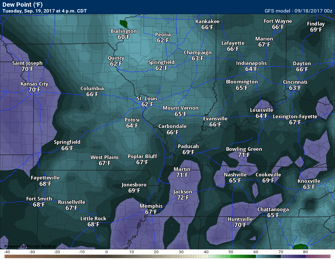
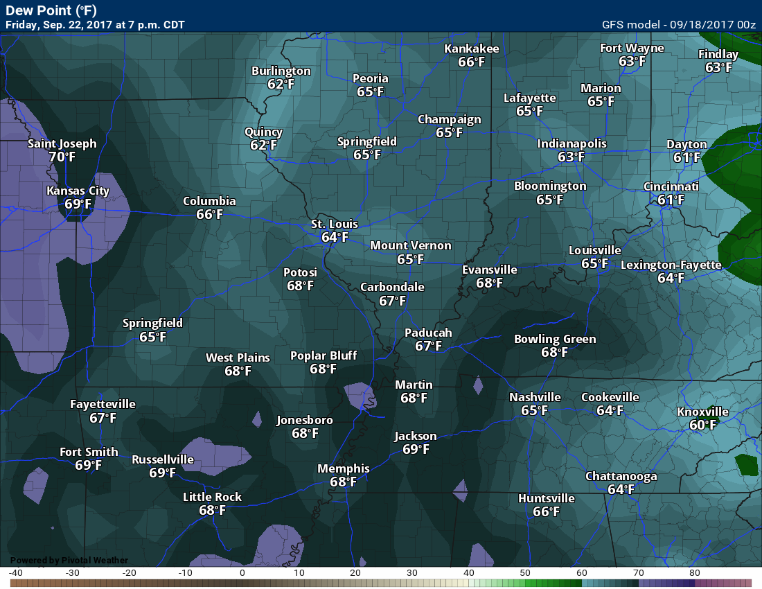
Dew point scale
Dew points are what control how you feel outside.

Click images to enlarge
Tuesday dew points
Wednesday dew points

Thursday dew points
Long range comments
The long range forecast is more of the same. Above normal temperatures are forecast to continue into early next week.
There are hints of a stronger cold front towards the middle of next week. We have several days to monitor that.
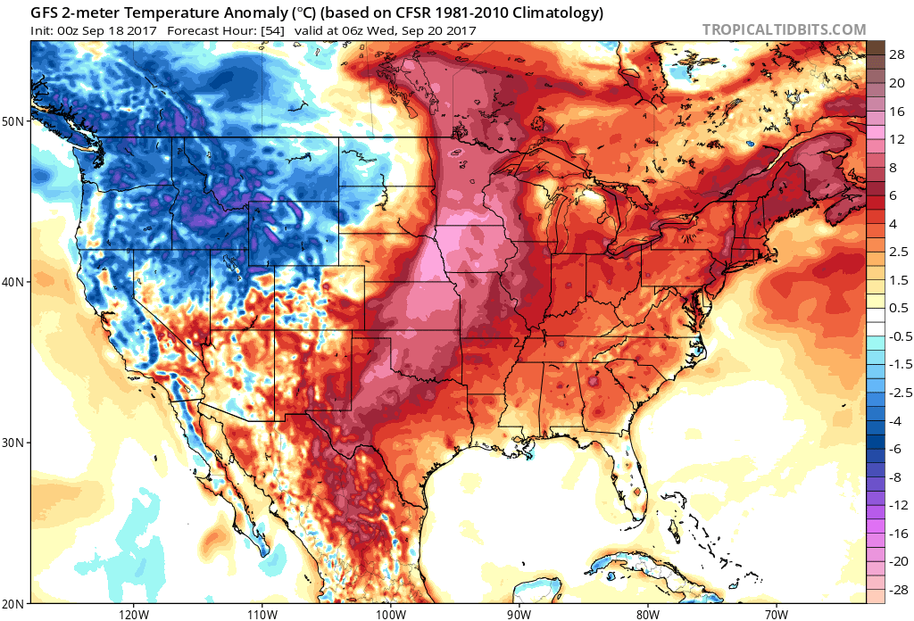
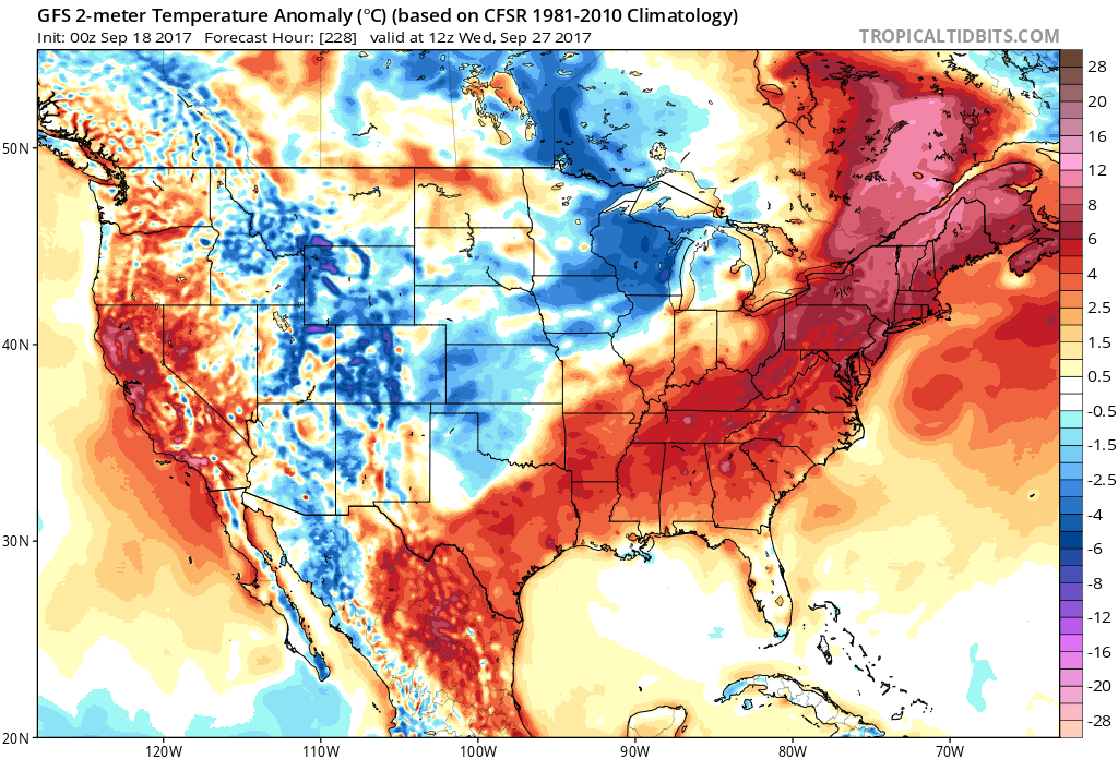
These temperature anomaly maps tell the story. Red represents above normal temperatures. Blue represents below normal temperatures.
Normal high temperatures are between 80 and 82 degrees. Normal low temperatures are between 54 and 56 degrees.
I selected a sampling of days.
Wednesday, September 20th
We are solidly in the above normal temperatures. The scale is on the right side of the image.
Saturday, September 23rd

Monday, September 25th

Wednesday, September 27th
This is an amazing stretch of warm weather. Much of August and early September was cooler than normal. I suppose the rubber-band has popped towards the other direction.
.
Are you subscribing to Weather Talk app/text messages and videos? This is what helps support all of the data you see each day.
We now offer premium videos for the short and long range forecasts! These videos are produced by a team of long range forecast experts. They are brought to you as bonus information. Activate text option four in order to receive these on your app or via text.
Subscribe at www.beaudodsonweather.com
We offer an Apple and Android app (scroll to the bottom of this page for more information).

Were you aware that I hired a team of meteorologists for long range videos?
To learn more, click this link
http://cms.weathertalk.com/meet-the-team/
.


We offer regional radars and local city radars – if a radar does not update then try another one. Occasional browsers need their cache cleared. You may also try restarting your browser. This will usually fix any problems.
During the winter you can track snow and ice by clicking the winterize button on the local city view interactive radars.
You may email me at beaudodson@usawx.com
Interactive Weather Radar Page. Choose the city nearest your location: Click this link
National interactive radar: Click this link.
The Beau Dodson Weather APP is ready for Apple and Android users. The app provides a faster way for you to receive my text messages. ATT and Verizon are not always reliable when it comes to speed.
Some of you have asked if you can receive the texts on your phone and the app. The answer to that is, yes. The Android app will automatically allow that to happen. On the Apple app, however, you will need to open your app and click the settings button. Make sure the green tab is OFF. Off means you will still receive the texts to your phone and the app. If you have any questions, then email me at beaudodson@usawx.com
The app is for text subscribers.
The direct download, for the Apple app, can be viewed here
https://itunes.apple.com/us/app/id1190136514
Here is the download link for the Android version Click Here
If you have not signed up for the texting service then you may do so at www.beaudodsonweather.com


——————————————————–
Your support helps with the following:

and

.

Whom do you trust for your weather information?
I have studied weather, in our region, since the late 1970’s. I have 40 years of experience in observing our regions weather patterns. My degree is in Broadcast Meteorology and a Bachelor’s of Science.
My resume includes:
Member of the American Meteorological Society.
NOAA Weather-Ready Nation Ambassador.
Meteorologist for McCracken County Emergency Management. I served from 2005 through 2015.
Meteorologist for McCracken County Rescue. 2015 through current
I own and operate the Southern Illinois Weather Observatory.
I am the chief meteorologist for Weather Talk LLC.
I am also a business owner in western Kentucky.
Recipient of the Mark Trail Award, WPSD Six Who Make A Difference Award, Kentucky Colonel, and the Caesar J. Fiamma” Award from the American Red Cross.
In 2005, I helped open the largest American Cross shelter in U.S. history. This was in Houston, Texas. I was deployed to help with the aftermath of Hurricane Katrina and Hurricane Rita. I was a shelter manager of one of the Houston, Texas shelter divisions.
In 2009 I was presented with the Kentucky Office of Highway Safety Award.
Recognized by the Kentucky House of Representatives for my service to the State of Kentucky leading up to several winter storms and severe weather outbreaks.
If you click on the image below you can read the Kentucky House of Representatives Resolution.

I am President of the Shadow Angel Foundation which serves portions of western Kentucky and southern Illinois.
There is a lot of noise on the internet. A lot of weather maps are posted without explanation. You need a trusted source for information.
My forecast philosophy is simple and straight forward.
- Communicate in simple terms
- To be as accurate as possible within a reasonable time frame before an event
- Interact with you on Twitter, Facebook, email, texts, and this blog
- Minimize the “hype” that you might see through other weather sources
- Push you towards utilizing wall-to-wall LOCAL TV coverage during severe weather events

Sign up for my AWARE email by clicking here.
I typically send AWARE emails before severe weather, winter storms, or other active weather situations. I do not email watches or warnings. The emails are a basic “heads up” concerning incoming weather conditions