We have some great sponsors for the Weather Talk Blog. Please let our sponsors know that you appreciate their support for the Weather Talk Blog.
Milner and Orr Funeral Home and Cremation Services located in Paducah, Kentucky and three other western Kentucky towns – at Milner and Orr they believe in families helping families. You can find Milner and Orr on Facebook, as well.
![]()
.

Are you in need of new eye glasses? New contacts? Perhaps you need an eye exam. Then be sure and visit the Eye Care Associates of western Kentucky (the Paducah location).
For all of your families eye care needs. Visit their web-site here. Or, you can also visit their Facebook page.
.

Best at Enabling Body Shop Profitability since 1996. Located In Paducah Kentucky and Evansville Indiana; serving all customers in between. They provide Customer Service, along with all the tools necessary for body shops to remain educated and competitive. Click the logo above for their main web-site. You can find McClintock Preferred Finishes on Facebook, as well

Expressway Carwash and Express Lube are a locally owned and operated full service Carwash and Lube established in 1987. They have been proudly serving the community for 29 years now at their Park Avenue location and 20 years at their Southside location. They have been lucky enough to partner with Sidecar Deli in 2015, which allows them to provide their customers with not only quality service, but quality food as well. . If you haven’t already, be sure to make Expressway your one stop shop, with their carwash, lube and deli. For hours of operation and pricing visit www.expresswashlube.com or Expressway Carwash on Facebook.

TORNADO SHELTERS! Endrizzi’s Storm Shelters – For more information click here. Endrizzi Contracting and Landscaping can be found on Facebook, as well – click here
I have launched the new weather texting service! I could use your help. Be sure and sign up and fully support all of the weather data you see each day.
This is a monthly subscription service. Supporting this helps support everything else. The cost is $3 a month for one phone, $5 a month for three phones, and $10 a month for seven phones.
For more information visit BeauDodsonWeather.com
Or directly sign up at Weathertalk.com


This forecast update covers far southern Illinois, far southeast Missouri, and far western Kentucky. See the coverage map on the right side of the blog.
.
New! Video page on the main Weather Talk web-site.
I am posting videos each day on the WeatherTalk website.
The videos can be found under the BeauCast tab. Click here.
.
September 17, 2016
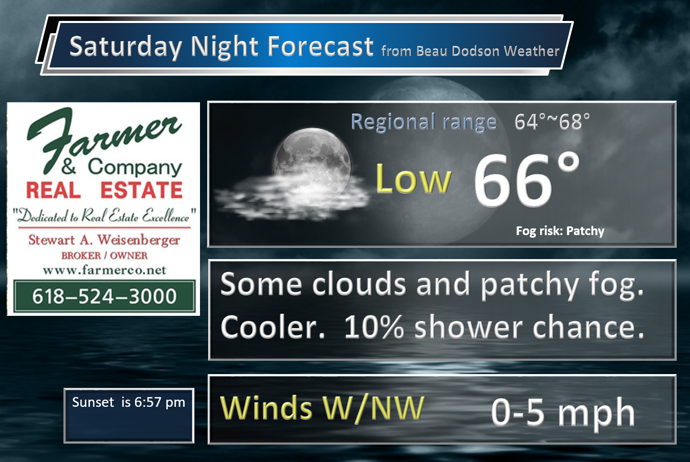
Sunset will be at 6:57 p.m.
Moonrise will be at 7:48 p.m. and moonset will be at 7:28 a.m. Waning Gibbous
.
Saturday Night – Clearing sky conditions with patchy fog developing. Isolated shower or thunderstorm chance before 8 pm.
What impact is expected? Patchy fog. Isolated wet roadways and lightning before 8 pm.
Temperatures: Lows in the 65-70 degree range
Winds: Winds southwest at 4-8 mph.
What is the chance for precipitation? MO ~ 10%. IL ~ 10%. KY~ 20% . TN ~ 20%
Coverage of precipitation: Isolated if anything at all
Is severe weather expected? No
My confidence in this part of the forecast verifying: High. This forecast should verify.
Should I cancel my outdoor plans? No, glance at radar early in the evening.
.
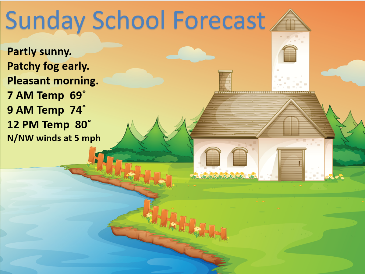
September 18, 2016
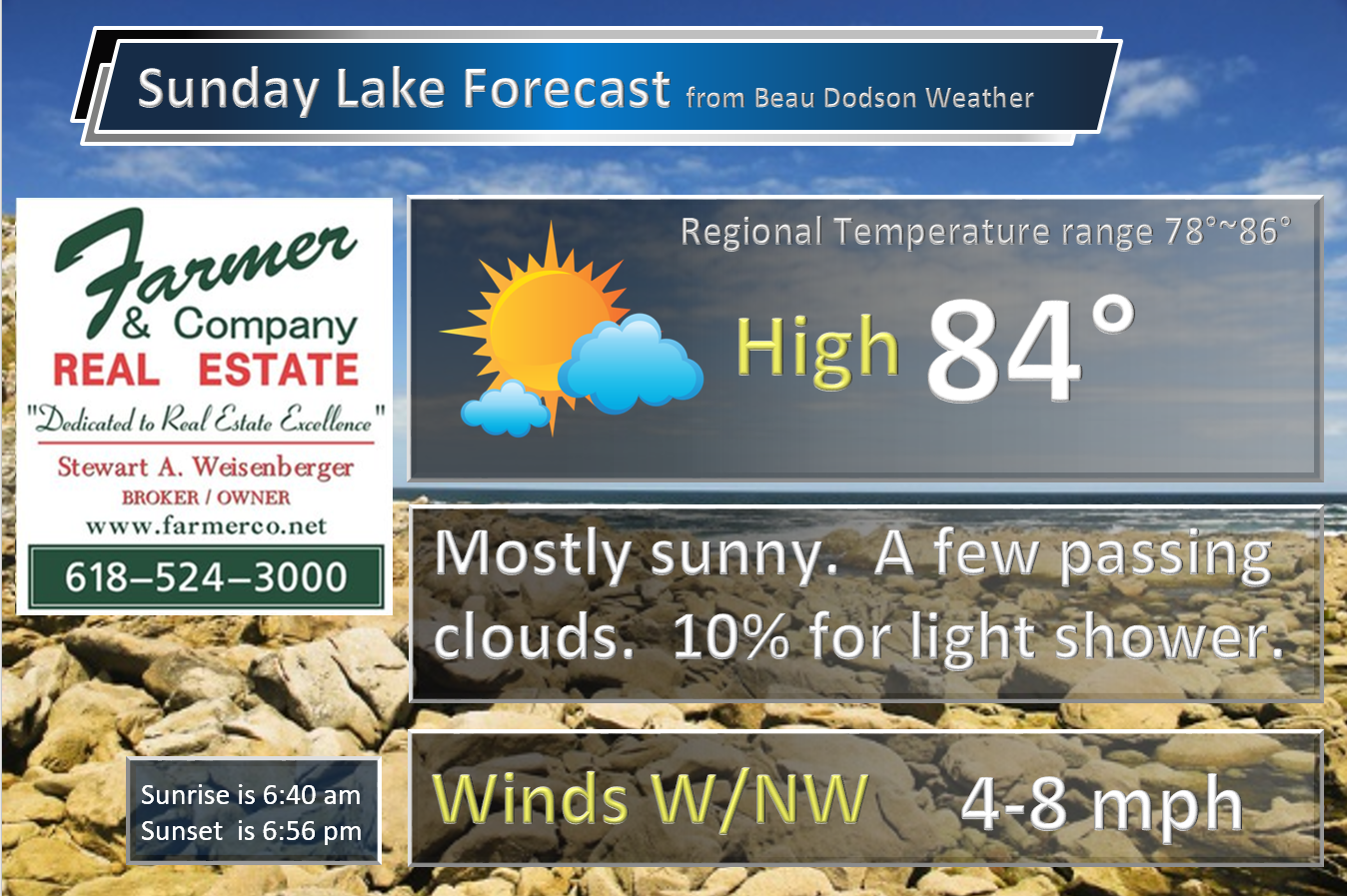
Sunday: Mostly sunny. A few passing clouds from time to time. Only a small chance for an isolated shower (mostly over the Bootheel and western Tennessee).
What impact is expected? Most likely none.
Temperatures: High temperatures in the 80-85 degree range.
Winds: Northwest/north winds at 5-10 mph with gusts to 12 mph.
What is the chance for precipitation? MO ~ 20%. IL ~ 10%. KY ~ 10% . TN ~ 20%
Coverage of precipitation? Most likely none. Small chance for the Missouri Bootheel and western Tennessee.
Is severe weather expected? No
My confidence in this part of the forecast verifying: High. This forecast should verify.
Should I cancel my outdoor plans? No
Sunrise will be at 6:40 a.m. and sunset will be at 6:56 p.m.
UV index will be 8-10. High
Moonrise will be at 8:28 p.m. and moonset will be at 8:38 a.m. Waning Gibbous
.
Sunday Night – Mostly clear. Patchy fog.
What impact is expected? Patchy fog could lower visibility in a few spots.
Temperatures: Lows in the 58-64 degree range
Winds: Winds northwest at 4-8 mph.
What is the chance for precipitation? MO ~ 10%. IL ~ 10%. KY~ 10% . TN ~ 10%
Coverage of precipitation: Most likely none.
Is severe weather expected? No
My confidence in this part of the forecast verifying: High. This forecast should verify.
Should I cancel my outdoor plans? No
.
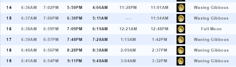
September 19, 2016
Monday: Partly cloudy.
What impact is expected? None
Temperatures: High temperatures in the 76-84 degree range.
Winds: Northwest/north winds at 5-10 mph with gusts to 12 mph.
What is the chance for precipitation? MO ~ 0%. IL ~ 0%. KY ~ 0% . TN ~ 0%
Coverage of precipitation? Most likely none.
Is severe weather expected? No
My confidence in this part of the forecast verifying: Medium. Some adjustments to the forecast might be necessary.
Should I cancel my outdoor plans?
Sunrise will be at 6:41 a.m. and sunset will be at 6:54 p.m.
UV index will be 8~10. High
Moonrise will be at 9:11 p.m. and moonset will be at 9:48 a.m. Waning Gibbous
.
Monday Night – Partly cloudy. Patchy fog possible.
What impact is expected? Patchy fog could lower visibility in a few spots.
Temperatures: Lows in the 62-66 degree range
Winds: Winds variable in direction at 0-5 mph.
What is the chance for precipitation? MO ~ 0%. IL ~ 0%. KY~ 0% . TN ~ 0%
Coverage of precipitation: None
Is severe weather expected? No
My confidence in this part of the forecast verifying: Medium. Some adjustments to the forecast might be necessary.
Should I cancel my outdoor plans? No
.
September 20, 2016
Tuesday: Partly to mostly sunny. Warmer. Just a small chance for a sprinkle.
What impact is expected? None
Temperatures: High temperatures in the 85-90 degree range.
Winds: Variable winds at 5-10 mph
What is the chance for precipitation? MO ~ 20%. IL ~ 20%. KY ~ 10% . TN ~ 10%
Coverage of precipitation? Most likely isolated to none. Some data shows a couple of showers over our northern counties.
Is severe weather expected? No
My confidence in this part of the forecast verifying: Medium. Some adjustments to the forecast might be necessary.
Should I cancel my outdoor plans? No
Sunrise will be at 6:41 a.m. and sunset will be at 6:53 p.m.
UV index will be 7-9. High
Moonrise will be at 9:56 p.m. and moonset will be at 10:57 a.m. Waning Gibbous
.
Tuesday Night – Mostly clear to partly cloudy.
What impact is expected? Most likely none.
Temperatures: Lows in the 62-66 degree range
Winds: Winds north and northeast at 3-6 mph.
What is the chance for precipitation? MO ~ 10%. IL ~ 10%. KY~ 10% . TN ~ 10%
Coverage of precipitation: None
Is severe weather expected? No
My confidence in this part of the forecast verifying: Medium. Some adjustments to the forecast might be necessary.
Should I cancel my outdoor plans? No
.
More information on the UV index. Click here
.
The School Bus Stop Forecast is sponsored by Heath Health and Wellness. Located next to Crowell Pools in Lone Oak, Kentucky.
Visit their web-site here. And. visit Heath Health Foods on Facebook!

Heath Health Foods is a locally owned and operated retail health and wellness store. Since opening in February 2006; the store has continued to grow as a ministry with an expanding inventory which also offers wellness appointments and services along with educational opportunities. Visit their web-site here. And. visit Heath Health Foods on Facebook!
.
The weekend forecast is sponsored by Farmer and Company Real Estate. Click here to visit their site.

Farmer & Company Real Estate is proud to represent buyers and sellers in both Southern Illinois and Western Kentucky. With 13 licensed brokers, we can provide years of experience to buyers & sellers of homes, land & farms and commercial & investment properties. We look forward to representing YOU! Follow us on Facebook, as well

Don’t forget to check out the Southern Illinois Weather Observatory web-site for weather maps, tower cams, scanner feeds, radars, and much more! Click here

An explanation of what is happening in the atmosphere over the coming days
- What happened to all the rain on Saturday?
- Sunday should be nice
- Looking ahead. Cooler weather in the charts?
Well, I can’t say I was happy with the forecast for Saturday. Although, I did mention this was a possibility. The cold front sped up overnight. The main band of heavy showers and thunderstorms swept across our region during the early morning hours. That left us with a lot of clouds and just a few remaining showers and storms. Certainly was a lot less coverage of precipitation than I was thinking just 24 hours ago. Sometimes that happens.
The NAM model guidance actually showed that scenario. It was the outlier. In the end, it was right!
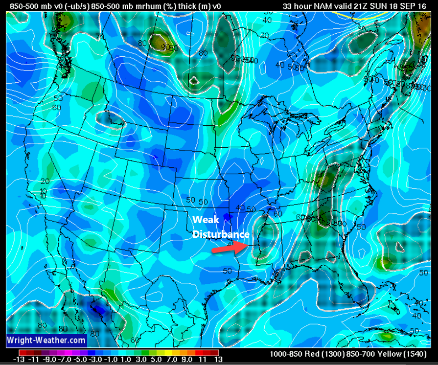
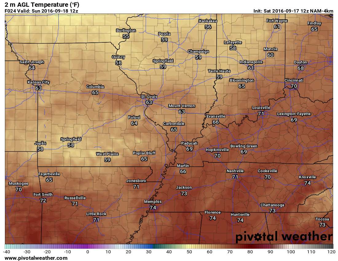
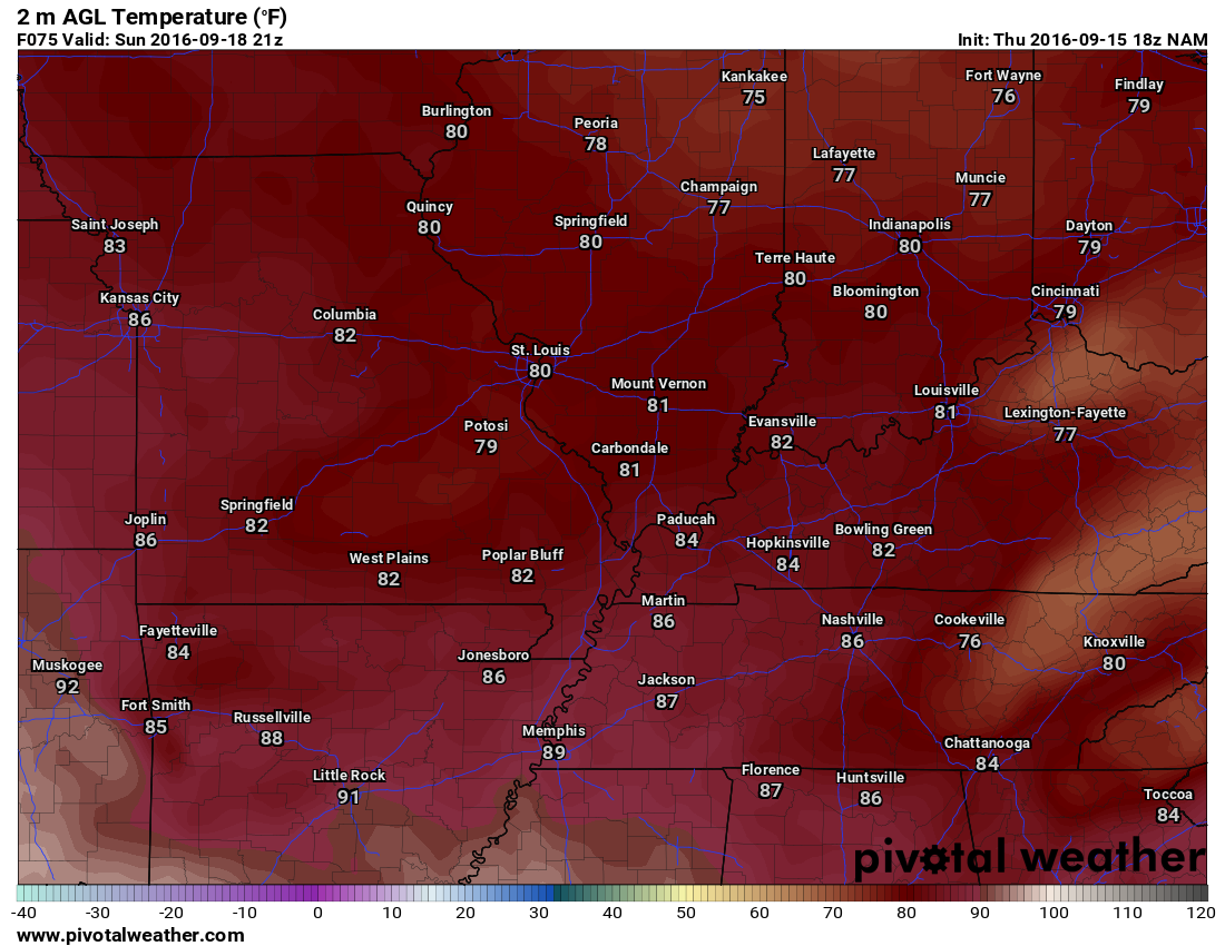
Sunday will deliver mostly sunny sky conditions. Just a few passing clouds as a weak disturbance passes to our south. There is a tiny chance for a stray shower. Temperatures will warm into the 80’s. Nice day for outdoor activities. There could be some patchy morning fog.
Here is that weak disturbance that will pass to our south on Sunday. Maybe a small chance for a shower over the Missouri Bootheel and western Tennessee.
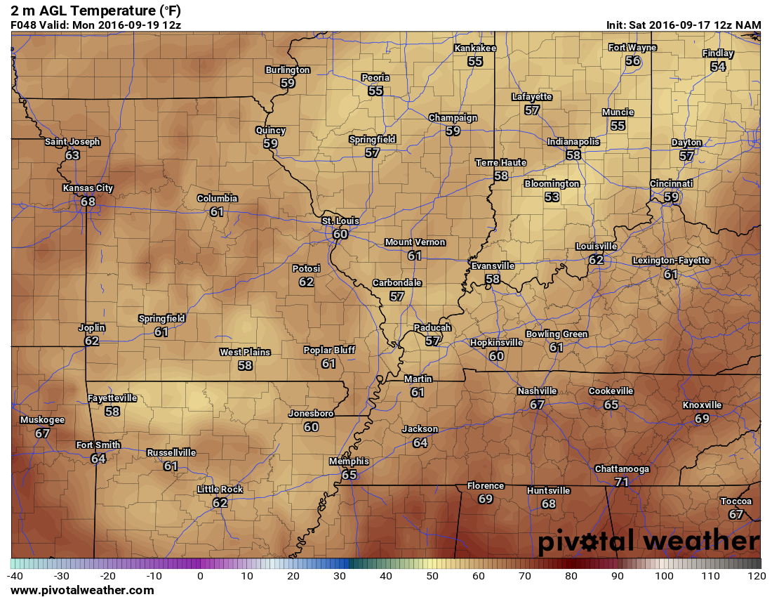
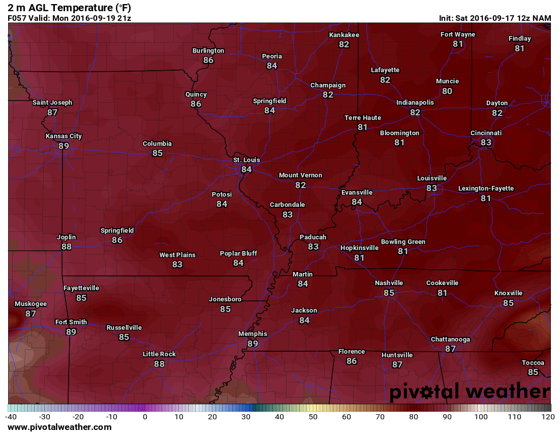
We will warm up a bit on Monday and Tuesday. Temperatures will rise into the middle and upper 80’s on both days. Above normal temperatures. We can’t shake the summer temperatures.
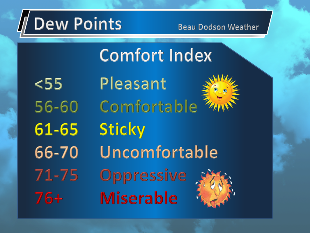
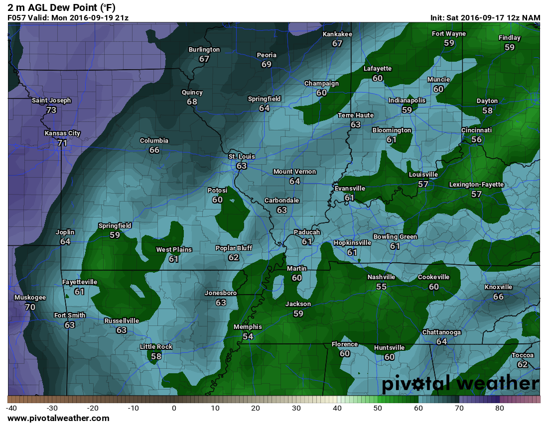
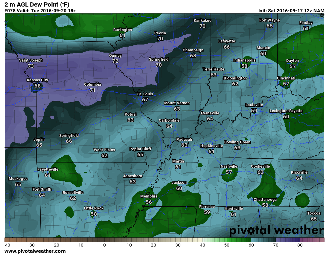
Dew points will be in the upper 50’s to upper 60’s. They will fluctuate a bit. Upper 50’s to lower 60’s would feel nice. Moving into the upper 60’s is where it becomes muggier.
Here is the Monday afternoon dew point map.
Here is the Tuesday few point map
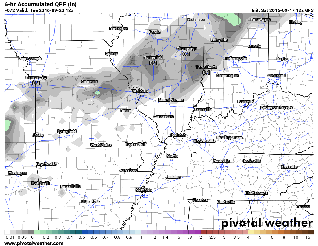
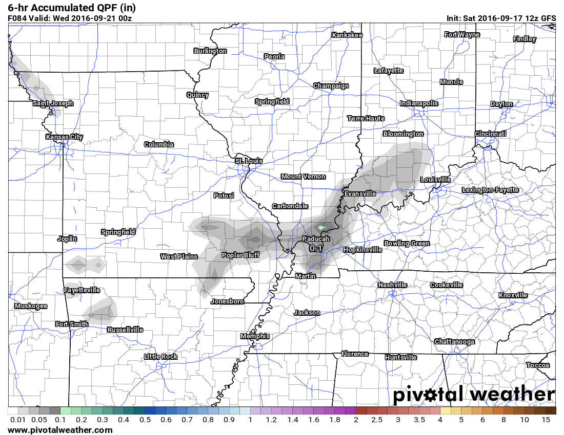
Both Monday and Tuesday should be dry. On Tuesday, a cold will approach our area from the north. Model guidance spits out a few drops of rain in our area. I believe it will be mostly dry. Perhaps a few clouds. I will keep an eye on it. Some of the data shows heavier thunderstorms over Iowa into northern and central Illinois.
Here is what the model is showing for Tuesday and Tuesday night. Just a hint of light precipitation according to the GFS model guidance. Other models show heavier storms to our north. The grey area represents six hour rainfall totals. Not much in our area.
This is the GFS model for Tuesday morning at 7 am. See the sprinkles to our north? Those are rainfall totals. Not much.
This next graphic is for Tuesday at 7 pm. Notice how the clouds and sprinkles shifted southward? Again, it will probably end up mostly dry. Perhaps a few clouds.
I am watching a cold front for Friday or Saturday. Long way off and I don’t have a lot of confidence in the placement. Let’s keep an eye on it. Maybe some showers and storms along the front. Here are the six hour rainfall totals according to the GFS for next Saturday afternoon.
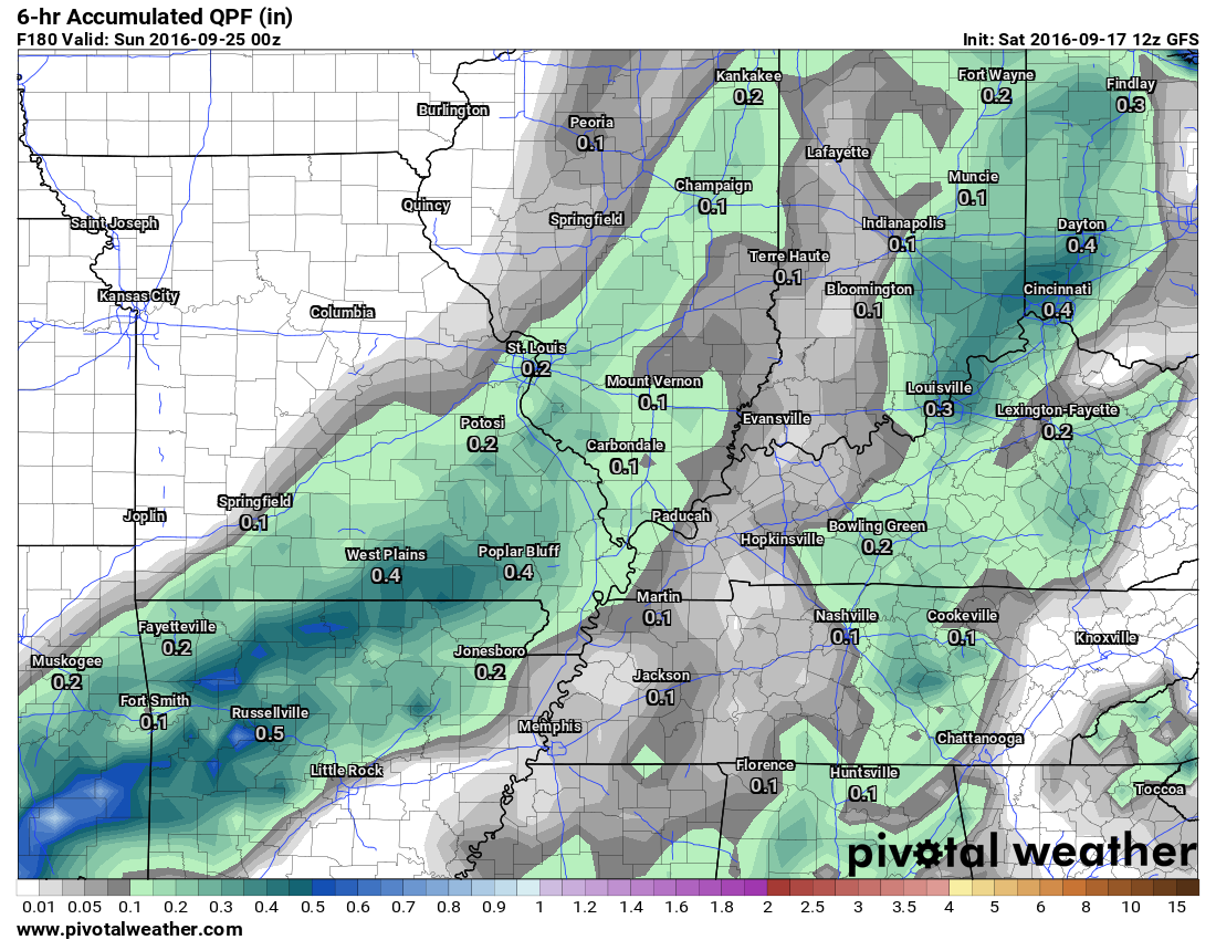
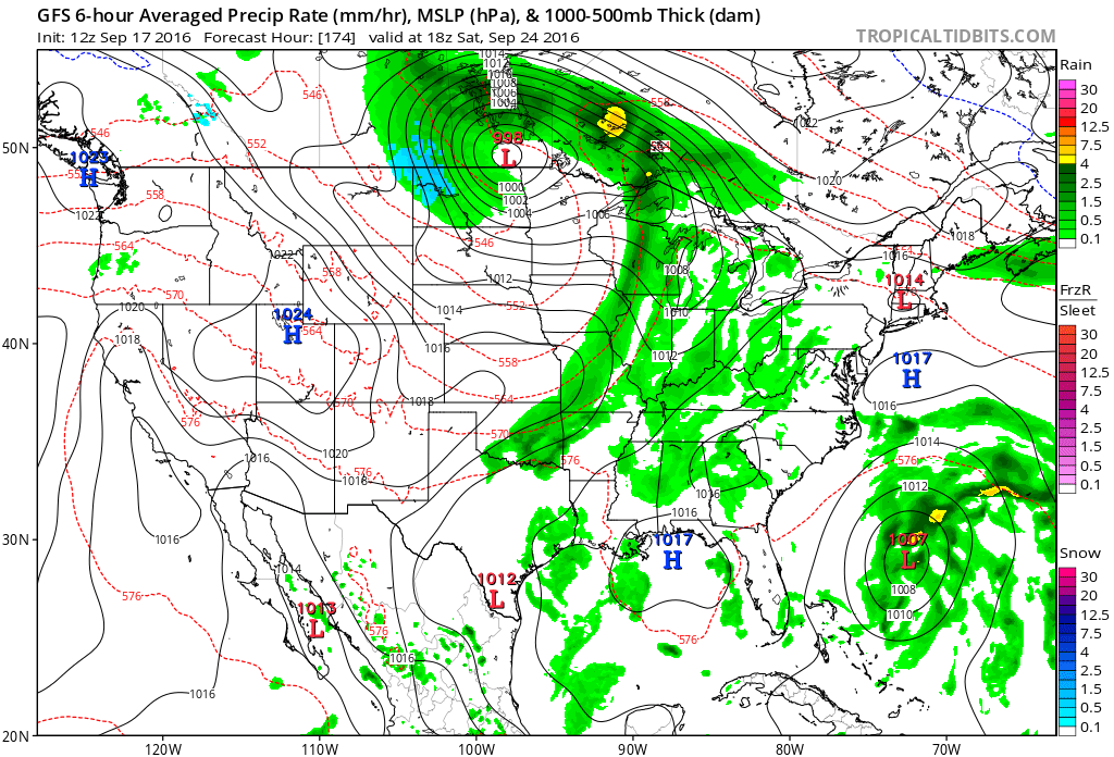
Here is the weather map showing that cold front next Saturday. The area of low pressure is in Canada (north of North Dakota). The cold front would extend from Wisconsin into Missouri and Oklahoma. The front would then sweep eastward. Still several days to monitor trends.
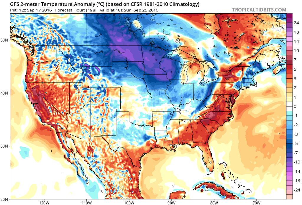
You can see the temperature anomaly forecast map is picking up on the front, as well. Red is above normal temperatures. Blue represents below normal temperatures. Notice how we are above normal ahead of the front. Temperatures fall off behind the front.
This first map is for Saturday afternoon.

This next map is for next Sunday. Below normal temperatures behind the front.
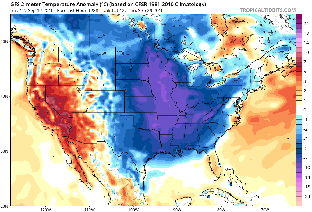
Look what happens the last week of the month. Perhaps a stronger cold front? This is in the long long range. Low confidence. The GFS does show a sharp cold snap. Plenty of time to monitor. I know some of you are looking for fall temperatures.
Don’t forget, severe storms can happen during the fall months. We are heading into our fall uptick time frame. Normally that runs from late September into November. Tornadoes are not uncommon in our area during the fall month.
Here is the temperature anomaly map for September 29th. WELL below normal temperatures according to the GFS guidance. Time will tell!
How much rain is forecast to fall over the coming days?
.
Saturday night through Monday night should be dry. There is only a small chance for a passing shower on Sunday. Less than 20% risk.
.
.
.
Sunday afternoon high temperature
.
.
Monday morning lows
.
.
Monday afternoon highs
.
.
Storm Tracking Radar


We have regional radars and local city radars – if a radar does not seem to be updating then try another one. Occasional browsers need their cache cleared. You may also try restarting your browser. That usually fixes the problem. Occasionally we do have a radar go down. That is why I have duplicates. Thus, if one fails then try another one.
If you have any problems then please send me an email beaudodson@usawx.com
WEATHER RADAR PAGE – Click here —
We also have a new national interactive radar – you can view that radar by clicking here.
Local interactive city radars include St Louis, Mt Vernon, Evansville, Poplar Bluff, Cape Girardeau, Marion, Paducah, Hopkinsville, Memphis, Nashville, Dyersburg, and all of eastern Kentucky – these are interactive radars. Local city radars – click here

Live Lightning Data – zoom and pan: Click here
Live Lightning Data with sound (click the sound button on the left side of the page): Click here

Can we expect severe thunderstorms over the next 24 to 48 hours? Remember that a severe thunderstorm is defined as a thunderstorm that produces 58 mph winds or higher, quarter size hail or larger, and/or a tornado.
.
Sunday through Wednesday: No severe weather anticipated.

.
Updated rain chances and temperatures.
.

.
No major concerns. Perhaps some morning patchy fog over the coming days. That would lower visibility.
.
..

 The latest 8-14 day temperature and precipitation outlook. Note the dates are at the top of the image. These maps DO NOT tell you how high or low temperatures or precipitation will be. They simply give you the probability as to whether temperatures or precipitation will be above or below normal.


Here are the current river stage forecasts. You can click your state and then the dot for your location. It will bring up the full forecast and hydrograph.

Who do you trust for your weather information and who holds them accountable?
I have studied weather in our region since the late 1970’s. I have 37 years of experience in observing our regions weather patterns. I hold a Bachelor’s of Science in Geo-sciences with a concentration in Broadcast Meteorology. I graduated from Mississippi State University.
My resume includes:
Member of the American Meteorological Society.
NOAA Weather-Ready Nation Ambassador.
Meteorologist for McCracken County Emergency Management. I served from 2005 through 2015
Meteorologist for the McCracken County Rescue Squad 2015-current
I own and operate the Southern Illinois Weather Observatory.
Recipient of the Mark Trail Award, WPSD Six Who Make A Difference Award, Kentucky Colonel, and the Caesar J. Fiamma” Award from the American Red Cross.
In 2009 I was presented with the Kentucky Office of Highway Safety Award.
Recognized by the Kentucky House of Representatives for my service to the State of Kentucky leading up to several winter storms and severe weather outbreaks.
I am also President of the Shadow Angel Foundation which serves portions of western Kentucky and southern Illinois.
There is a lot of noise on the internet. A lot of weather maps are posted without explanation. Over time you should learn who to trust for your weather information.
My forecast philosophy is simple and straight forward.
- Communicate in simple terms
- To be as accurate as possible within a reasonable time frame before an event
- Interact with you on Twitter, Facebook, and the blog
- Minimize the “hype” that you might see on television or through other weather sources
- Push you towards utilizing wall-to-wall LOCAL TV coverage during severe weather events
I am a recipient of the Mark Trail Award, WPSD Six Who Make A Difference Award, Kentucky Colonel, and the Caesar J. Fiamma” Award from the American Red Cross. In 2009 I was presented with the Kentucky Office of Highway Safety Award. I was recognized by the Kentucky House of Representatives for my service to the State of Kentucky leading up to several winter storms and severe weather outbreaks.
If you click on the image below you can read the Kentucky House of Representatives Resolution.

Many of my graphics are from www.weatherbell.com – a great resource for weather data, model data, and more


You can sign up for my AWARE email by clicking here I typically send out AWARE emails before severe weather, winter storms, or other active weather situations. I do not email watches or warnings. The emails are a basic “heads up” concerning incoming weather conditions.