

.
You must have a Weather Talk subscription ($3 a month) to view the videos.
Videos are posted on the www.weathertalk.com website. Once there, click the Beau Video-Cast tab. Long Range Video Update
If you believe you missed a video then you can also click the LIVE FEED link on the Weather Talk website. You will find the most recent and previous seven days worth of links on that page.
I can app/text you the videos, as well. Make sure you have text option FOUR turned on. That would be the Weather Extra text option. Sign up for the app/text messages, videos, and more at www.beaudodsonweather.com
.

.
This forecast update covers southern Illinois, southeast Missouri, western Kentucky. and extreme northwest Tennessee.
…
September 13, 2017
Wednesday Night Forecast Details:
Forecast: Some clouds. A chance for scattered showers and drizzle. Rain should be ending. Patch fog.
Temperatures: MO ~ 56 to 64 IL ~ 56 to 64 KY ~ 58 to 64 TN ~ 58 to 64
Winds: Variable at 0 to 5 mph
What impacts are anticipated from the weather? Perhaps wet roadways and patchy fog with lower visibility.
My confidence in the forecast verifying: High
Is severe weather expected? No
The NWS defines severe weather as 58 mph winds or great, 1″ hail or larger, and/or tornadoes
What is the chance of precipitation? MO ~ 20% IL ~ 20% KY ~ 20% TN ~ 20%
Coverage of precipitation: Widely scattered
Should I cancel my outdoor plans? No, but monitor updates
.
September 14, 2017
Thursday Forecast Details
Forecast: Patchy morning fog. Becoming partly sunny to sunny. Warmer.
Temperatures: MO ~80 to 84 IL ~ 80 to 84 KY ~ 80 to 84 TN ~ 80 to 84
Winds: Variable winds at 0 to 6 mph
What impacts are anticipated from the weather? Most likely none.
My confidence in the forecast verifying: High
Is severe weather expected? No
The NWS defines severe weather as 58 mph winds or great, 1″ hail or larger, and/or tornadoes
What is the chance of precipitation? MO ~ 0% IL ~ 0% KY ~ 0% TN ~ 0%
Coverage of precipitation: None anticipated
Should I cancel my outdoor plans? No
.
Thursday Night Forecast Details:
Forecast: Mostly clear. Patchy fog possible.
Temperatures: MO ~ 60 to 64 IL ~ 60 to 64 KY ~ 60 to 64 TN ~ 60 to 64
Winds: Variable at 0 to 5 mph
What impacts are anticipated from the weather? Lower visibility in areas with fog.
My confidence in the forecast verifying: High
Is severe weather expected? No
The NWS defines severe weather as 58 mph winds or great, 1″ hail or larger, and/or tornadoes
What is the chance of precipitation? MO ~ 0% IL ~ 0% KY ~ 0% TN ~ 0%
Coverage of precipitation: None
Should I cancel my outdoor plans? No
.
September 15, 2017
Friday Forecast Details
Forecast: Patchy morning fog. Mostly sunny. Mild. More humid.
Temperatures: MO ~ 84 to 88 IL ~ 82 to 85 KY ~ 82 to 86 TN ~ 84 to 88
Winds: South and southwest winds at 5 to 10 mph
What impacts are anticipated from the weather? Most likely none.
My confidence in the forecast verifying: High
Is severe weather expected? No
The NWS defines severe weather as 58 mph winds or great, 1″ hail or larger, and/or tornadoes
What is the chance of precipitation? MO ~ 0% IL ~ 0% KY ~ 0% TN ~ 0%
Coverage of precipitation: None anticipated
Should I cancel my outdoor plans? No
.
Friday Night Forecast Details:
Forecast: Mostly clear. Patchy fog.
Temperatures: MO ~ 62 to 66 IL ~ 62 to 66 KY ~ 62 to 66 TN ~ 62 to 68
Winds: Variable winds at 5 mph becoming southeast
What impacts are anticipated from the weather? Lower visibility in fog
My confidence in the forecast verifying: High
Is severe weather expected? No
The NWS defines severe weather as 58 mph winds or great, 1″ hail or larger, and/or tornadoes
What is the chance of precipitation? MO ~ 0% IL ~ 0% KY ~ 0% TN ~ 0%
Coverage of precipitation: None
Should I cancel my outdoor plans? No
.
September 16, 2017
Saturday Forecast Details
Forecast: Patchy morning fog. Mostly sunny. Warm and a bit humid.
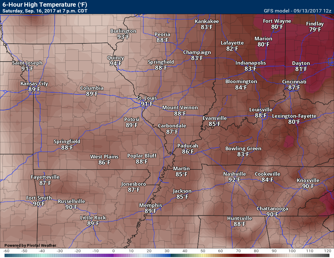
Temperatures: MO ~ 84 to 88 IL ~ 84 to 86 KY ~ 84 to 88 TN ~ 84 to 88
Winds: South winds at 5 to 10 mph
What impacts are anticipated from the weather? Most likely none.
My confidence in the forecast verifying: High
Is severe weather expected? No
The NWS defines severe weather as 58 mph winds or great, 1″ hail or larger, and/or tornadoes
What is the chance of precipitation? MO ~ 0% IL ~ 0% KY ~ 0% TN ~ 0%
Coverage of precipitation: None anticipated
Should I cancel my outdoor plans? No
.
Saturday Night Forecast Details:
Forecast: Mostly clear. Patchy fog possible.
Temperatures: MO ~ 64 to 68 IL ~ 64 to 68 KY ~ 64 to 68 TN ~ 64 to 68
What impacts are anticipated from the weather? Lower visibility if fog forms
My confidence in the forecast verifying: High
Is severe weather expected? No
The NWS defines severe weather as 58 mph winds or great, 1″ hail or larger, and/or tornadoes
What is the chance of precipitation? MO ~ 0% IL ~ 0% KY ~ 0% TN ~ 0%
Coverage of precipitation: None
Should I cancel my outdoor plans? No
.
September 17, 2017
Sunday Forecast Details
Forecast: Patchy morning fog. Mostly sunny. Warm and a bit humid.
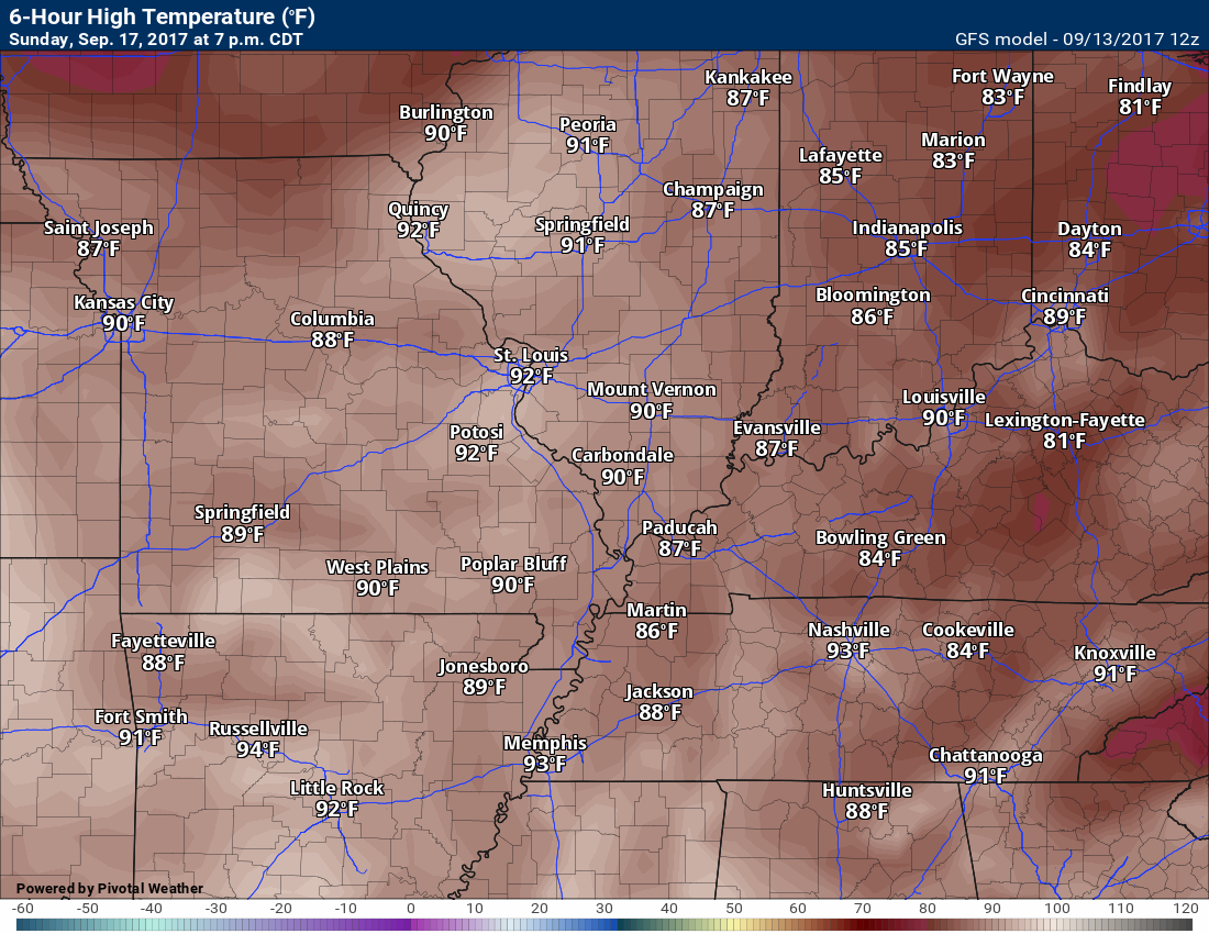
Temperatures: MO ~ 85 to 88 IL ~ 84 to 86 KY ~ 85 to 88 TN ~ 85 to 88
Winds: South winds at 5 to 10 mph
What impacts are anticipated from the weather? Most likely none.
My confidence in the forecast verifying: Medium
Is severe weather expected? No
The NWS defines severe weather as 58 mph winds or great, 1″ hail or larger, and/or tornadoes
What is the chance of precipitation? MO ~ 0% IL ~ 0% KY ~ 0% TN ~ 0%
Coverage of precipitation: None anticipated
Should I cancel my outdoor plans? No
.
Sunday Night Forecast Details:
Forecast: Mostly clear. Patchy fog possible.
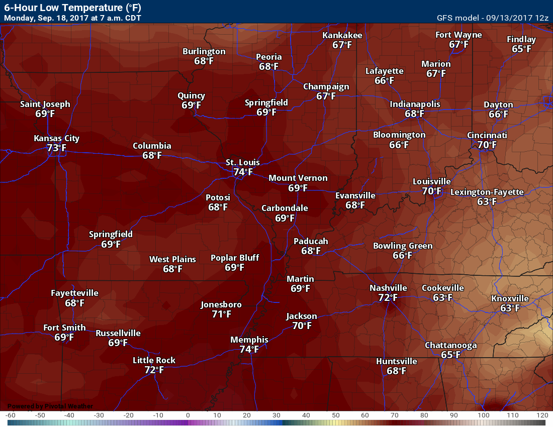
Temperatures: MO ~ 65 to 70 IL ~ 65 to 70 KY ~ 65 to 70 TN ~ 65 to 70
What impacts are anticipated from the weather?
My confidence in the forecast verifying: High
Is severe weather expected? No
The NWS defines severe weather as 58 mph winds or great, 1″ hail or larger, and/or tornadoes
What is the chance of precipitation? MO ~ 0% IL ~ 0% KY ~ 0% TN ~ 0%
Coverage of precipitation: None
Should I cancel my outdoor plans? No
.
September 18, 2017
Monday Forecast Details
Forecast: Partly sunny. Warm and humid. A chance for a few thunderstorms.
Temperatures: MO ~ 84 to 86 IL ~ 84 to 86 KY ~ 84 to 86 TN ~ 84 to 86
Winds: Southwest winds at 5 to 10 mph
What impacts are anticipated from the weather? Wet roadways. Lightning.
My confidence in the forecast verifying: Low
Is severe weather expected? No
The NWS defines severe weather as 58 mph winds or great, 1″ hail or larger, and/or tornadoes
What is the chance of precipitation? MO ~ 30% IL ~ 30% KY ~ 30% TN ~ 30%
Coverage of precipitation: Scattered
Should I cancel my outdoor plans? No, but monitor updates
.
Monday Night Forecast Details:
Forecast: Partly cloudy. A chance for a thunderstorm.
Temperatures: MO ~ 60 to 64 IL ~ 60 to 64 KY ~ 60 to 64 TN ~ 60 to 64
What impacts are anticipated from the weather? Wet roadways. Lightning
My confidence in the forecast verifying: Low
Is severe weather expected? No
The NWS defines severe weather as 58 mph winds or great, 1″ hail or larger, and/or tornadoes
What is the chance of precipitation? MO ~ 20% IL ~ 20% KY ~ 20% TN ~ 20%
Coverage of precipitation: Scattered
Should I cancel my outdoor plans? No, but monitor updates
.

Don’t forget to check out the Southern Illinois Weather Observatory web-site for weather maps, tower cams, scanner feeds, radars, and much more! Click here
.

A severe thunderstorm is defined as a storm that produces quarter size hail or larger, 58 mph winds or greater, and/or a tornado. That is the official National Weather Service definition of a severe thunderstorm
Wednesday night through Monday: Severe weather is not anticipated. Lightning is possible on Monday. Low confidence.
.

Overview
Are there any weather concerns
- Irma departs
- Warmer weather is on the way!
Short range
Confidence level in the short range forecast is high
Interactive Weather Radar Page. Choose the city nearest your location: Click this link
Irma is slowly, but surely, departing the area. Rain totals have not been all that impressive. Mostly on the light side. There was quite a bit of drizzle and some fog overnight.
Fog and drizzle will continue into Wednesday night, but should start to diminish as the night wears on.
As Irma departs, temperatures will rise again to more seasonal levels. As a matter of fact, Thursday into Wednesday should deliver 80’s to the region! Mid to upper 80’s are possible Friday into Monday. It is actually going to feel like summer, again.
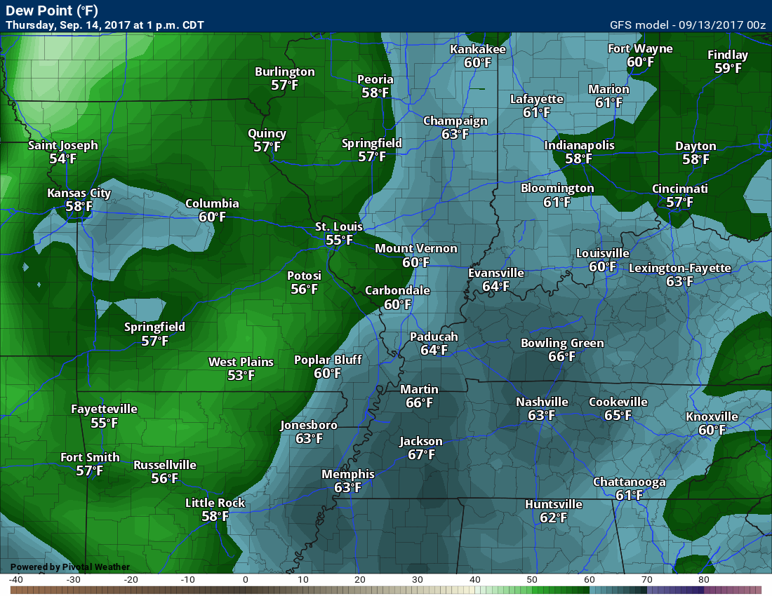
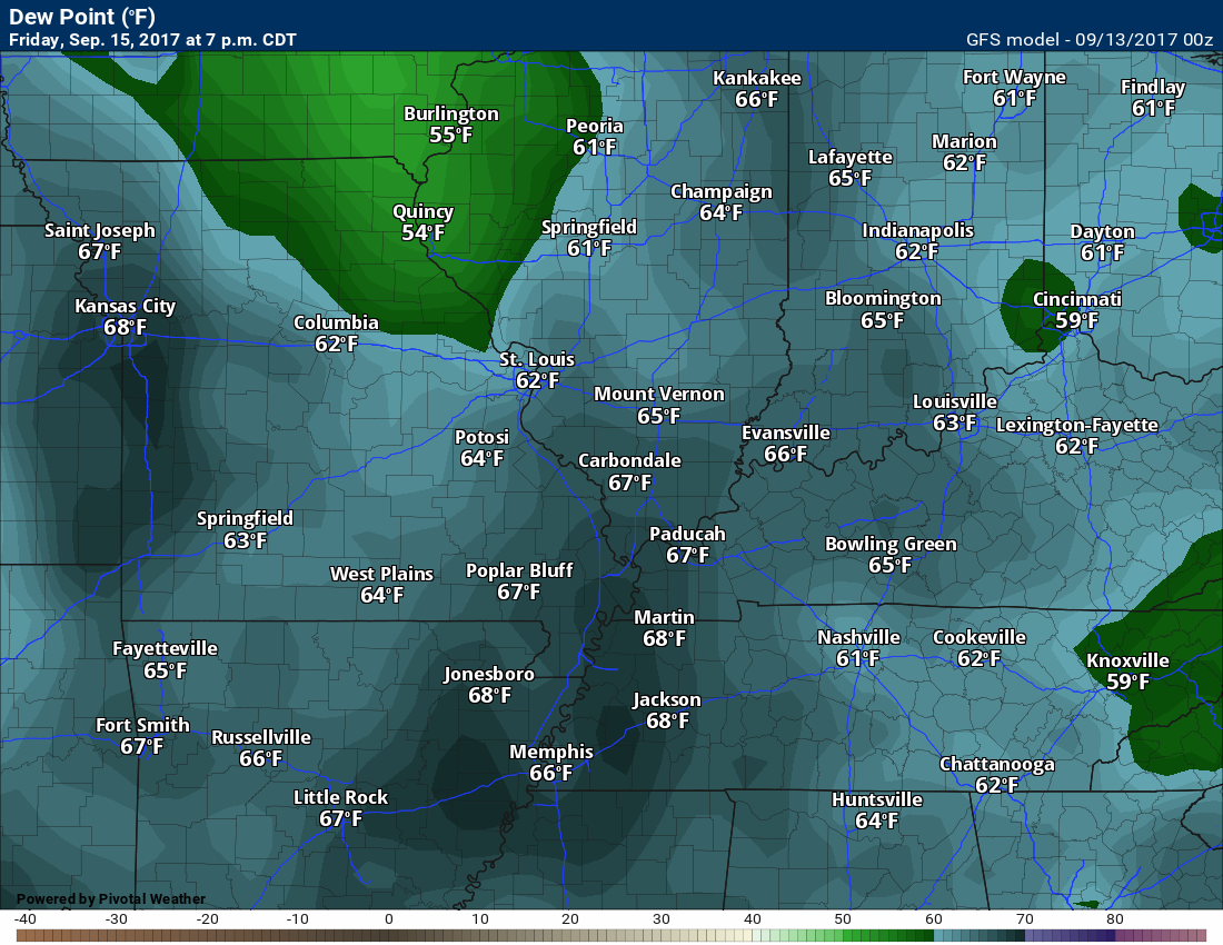
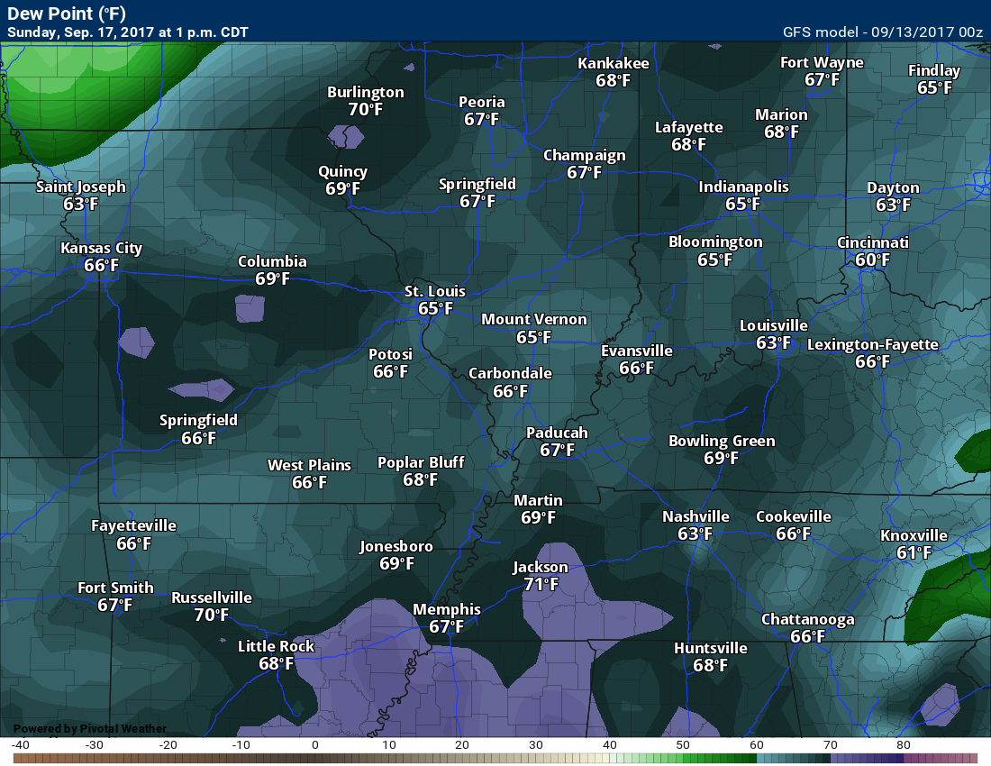
You are also going to notice a rise in dew points/humidity levels (see dew point chart below).
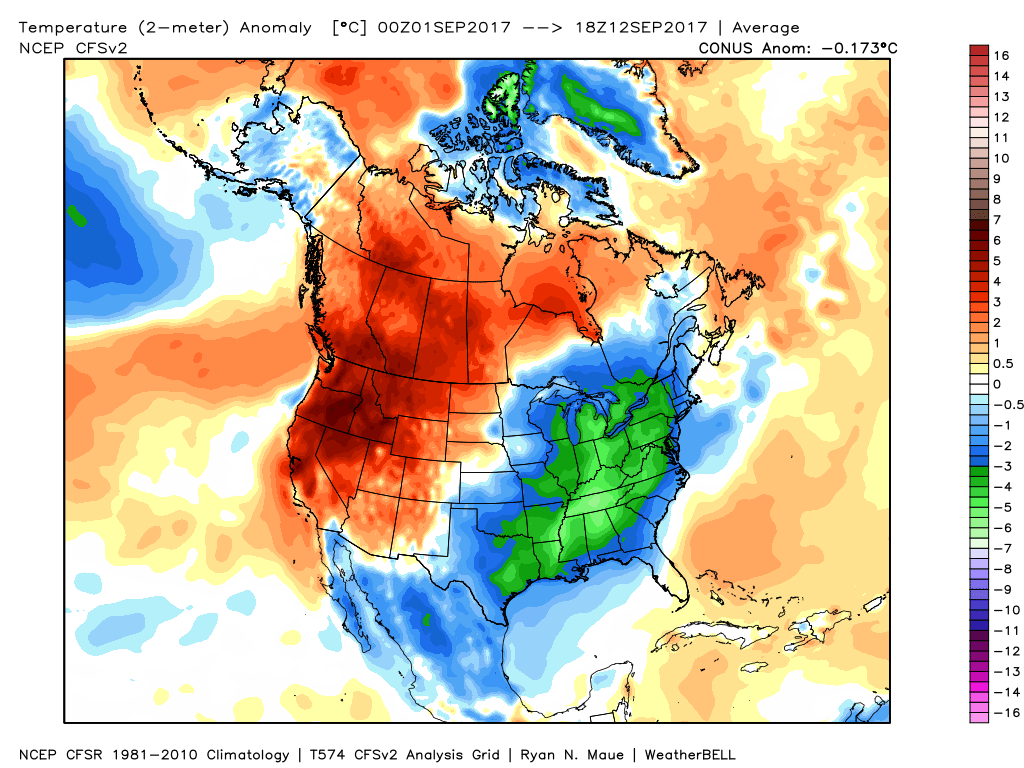
Here is the month to date temperature anomaly. It has been cooler than normal. You probably knew that already!
Click image to enlarge
This chart shows you how many degrees above or below normal the nation has been since September 1st.
We have actually been well below normal in the temperature department.
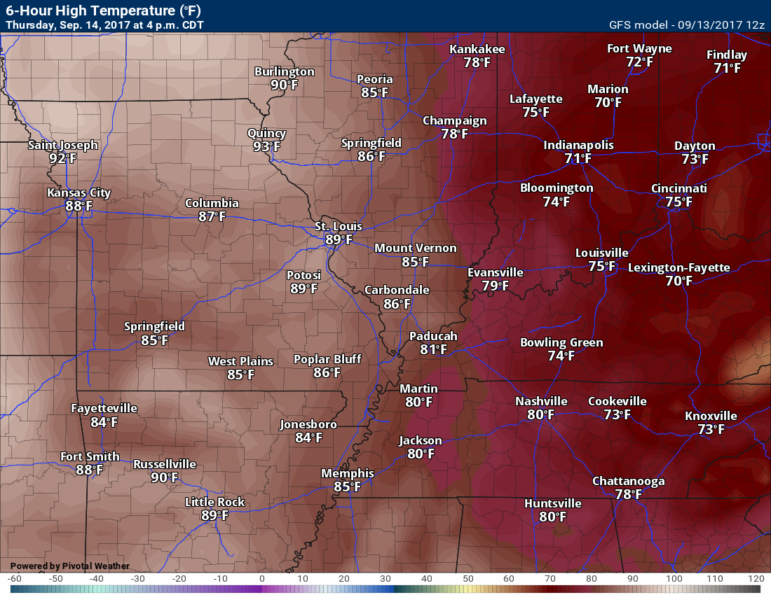
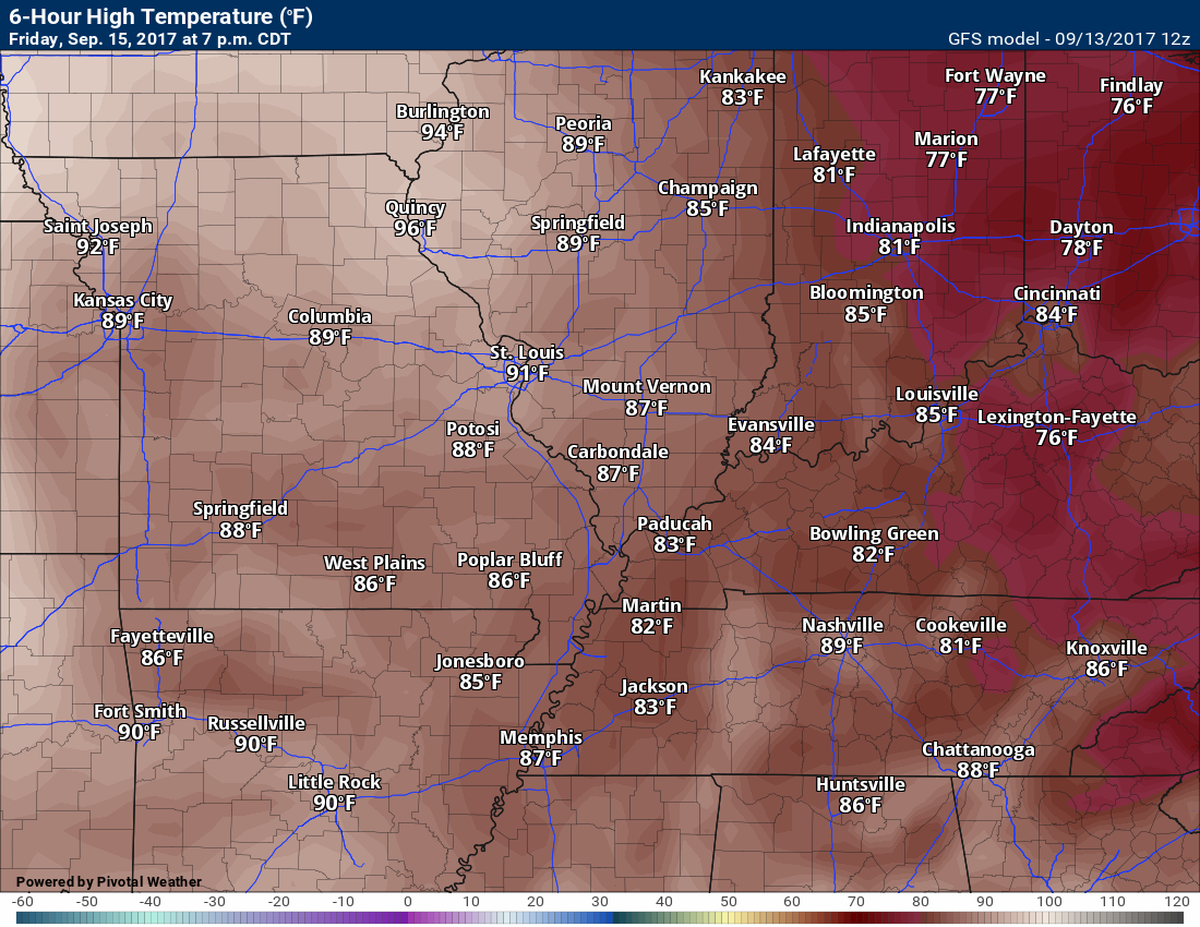
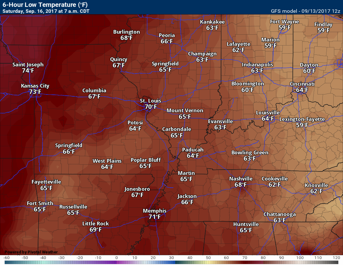
TEMPERATURE FORECAST
Click images to enlarge
Low temperatures for Wednesday night (below)

High temperatures for Thursday (below)
Low temperatures for Thursday night (below)
High temperatures for Friday
Low temperatures for Friday night
High temperatures for Saturday
Saturday night low temperatures

High temperatures for Sunday
Sunday night low temperatures
Dew point scale

Click images to enlarge
Dew points for Thursday
Dew points for Friday
Increasingly humid
Dew points for Saturday

Dew points for Sunday
Long range
The confidence level is high for the long range forecast.
A warming trend will push us back to summer conditions. This may last awhile. Some of the guidance is suggesting a prolonged period of above normal temperatures.
Here is the month to date temperature anomaly. If you thought it has been cool then you would be correct.
Click image to enlarge
Well below normal temperatures in the green.
The last seven days
Even cooler over the last seven days.

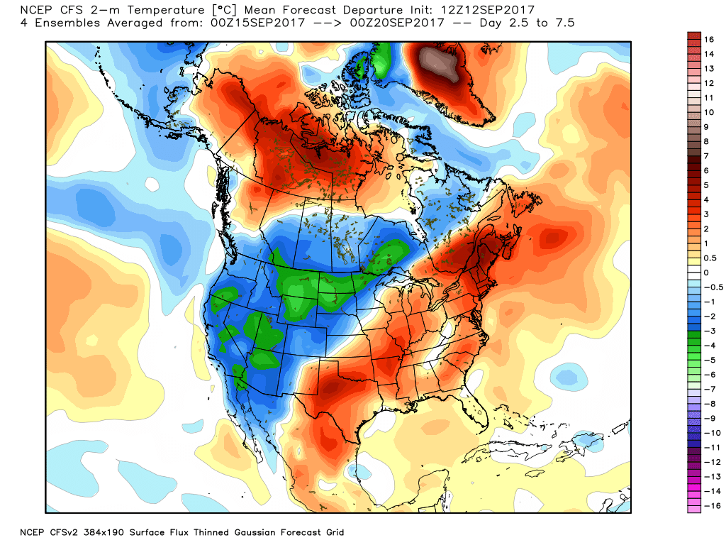
Let’s take a look at some of the model guidance for the coming weeks. They all point to above normal temperatures.
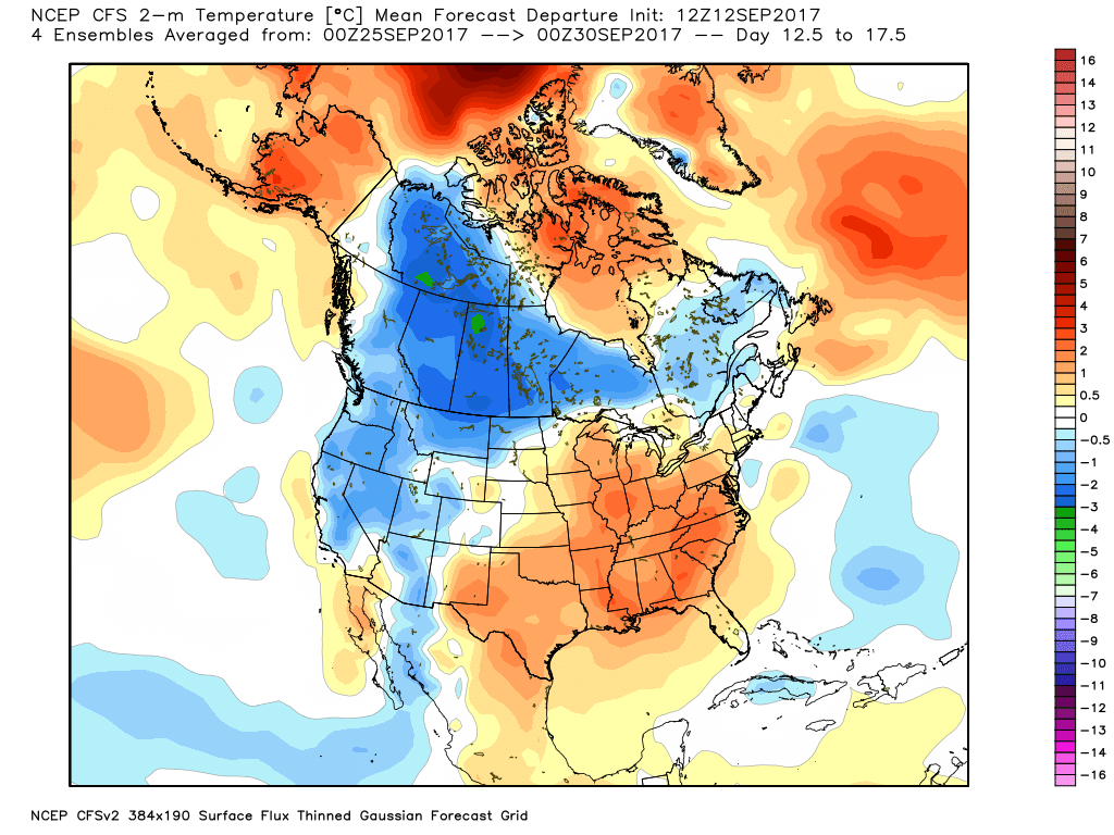
This is the September 15th through the 20th time period. If you were to average the temperatures together, this is what you would have. The red is indicating above normal probabilities.
Normal high temperatures, for this time of the year, are around 83 to 85. Normal low temperatures are around 58 to 60.
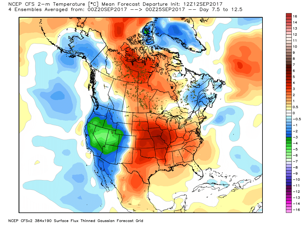
This next map is for September 20th through the 25th. Solidly in the above normal probabilities. Above normal temperatures appear likely.
This next image is for September 25th through September 30th
This particular model continues to point towards above normal temperatures. This would be a flip in the pattern from the last few weeks.
I know it has been dry for portions of the region. Not all, but portions.
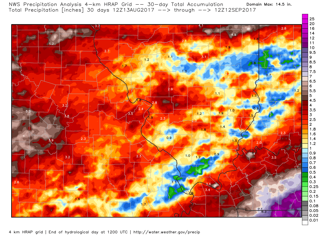
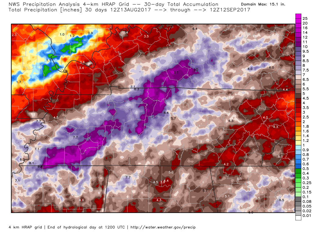
Hurricane Harvey dumped a considerable amount of rain from the Missouri Bootheel into portions of Kentucky and Tennessee.
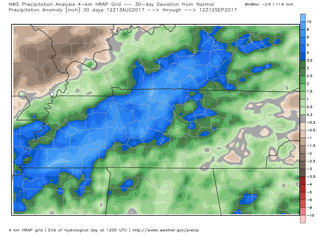
Let’s look at some precipitation deviations from normal maps. How many inches above or below normal has precipitation been.
30 day precipitation deviation. Note where Harvey tracked. That would be the blue area. Above normal precipitation.
This is the 30 day deviation from normal in inches. Scale is on the right side of the image.
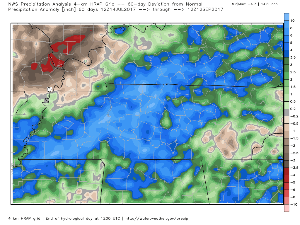
60 day deviation map
Look at that red area across a sliver of southeast Missouri and portions of southern Illinois. WELL below normal precipitation.
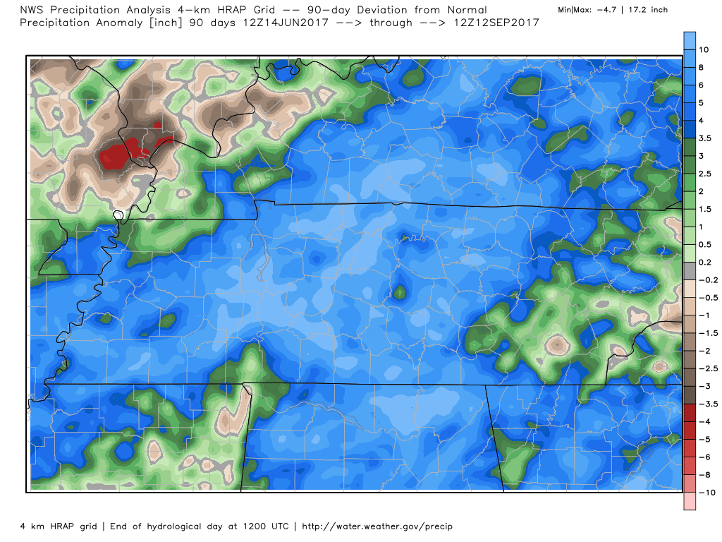
90 day deviation map
Notice portions of southeast Missouri into extreme southern Illinois have been very dry. This has been bad luck. Rain has broken up several times in those areas. It really has been luck of the draw. Normally you will see some areas with less rainfall than others.
This time around it ended up being far southeast Missouri and extreme southern Illinois.
Here is how much rain has fallen over the last 30 days. Again, notice the drier spots across portions of southeast Missouri and far southern Illinois.
Click images to enlarge.
This view shows you southeast Missouri, southern Illinois, portions of western Kentucky, and a sliver of Tennessee.
Again, click the map to enlarge. I know it is a bit messy trying to find the state borders.
Here is the 30 day rainfall for the southeast portion of our region. This is what has already fallen.
Again, it is obvious where Harvey tracked.
We are heading into a warmer pattern. Several cold fronts may pass through the area over the next three weeks. Each one could spark some showers and thunderstorms.
I am currently not tracking a large precipitation event.
The wild card will continue to be the tropics. If you remember a month or two ago I mentioned the potential for a hurricane hit in Texas and the Gulf Coast. We had that with Harvey. That delivered rain to portions of our local area.
Hurricane season will last into early November. We could have more activity in the Gulf of Mexico. This will need to be monitored.
Are you subscribing to the Weather Talk texts and videos?
We now have premiere videos for the short and long range forecasts! Make sure you have text option four turned on (green).
Sign up at www.beaudodsonweather.com
We also have an Apple and Android app (scroll down to bottom of the page for more information)

Were you aware that I have hired some help for long range videos? Short range videos, as well. An amazing team of meteorologists.
Click the link below to read more
http://cms.weathertalk.com/meet-the-team/
Weather Talk subscribers now have some of the best short and long range weather videos produced across the eastern United States.
.


We have regional radars and local city radars – if a radar does not update then try another one. Occasional browsers need their cache cleared. You may also try restarting your browser. That usually fixes the problem. Occasionally we do have a radar go down. That is why I have duplicates. Thus, if one fails then try another one.
During the winter you can track snow and ice by clicking the winterize button on the local city view interactive radars.
If you have any problems then please send me an email beaudodson@usawx.com
Interactive Weather Radar Page. Choose the city nearest your location: Click this link
National interactive radar: Click this link.
Local interactive city radars include St Louis, Mt Vernon, Evansville, Poplar Bluff, Cape Girardeau, Marion, Paducah, Hopkinsville, Memphis, Nashville, Dyersburg, and all of eastern Kentucky. These are interactive radars. Local city radars – click here
The Beau Dodson Weather APP is ready for Apple and Android users. The purpose of this app is for me to deliver your app/text messages instantly. ATT and Verizon have not always been reliable when it comes to speed. The app allows instant delivery.
Some of you have asked if you can receive the texts on your phone and the app. The answer to that is, yes. The Android app will automatically allow that to happen. On the Apple app, however, you will need to go into your app and click settings. Make sure the green tab is OFF. Off means you will still receive the texts to your phone and the app. If you have any questions, then email me at beaudodson@usawx.com
The app is for text subscribers.
The direct download, for the Apple app, can be viewed here
https://itunes.apple.com/us/app/id1190136514
If you have not signed up for the texting service then you may do so at www.beaudodsonweather.com

The Android app is also ready.
Remember, the app’s are for www.weathertalk.com subscribers. The app allows your to receive the text messages faster than ATT and Verizon.
Here is the download link for the Android version Click Here

——————————————————–
If you have not signed up for the texts messages, then please do. Link www.beaudodsonweather.com
Your support helps with the following:

and


Who do you trust for your weather information and who holds them accountable?
I have studied weather in our region since the late 1970’s. I have 39 years of experience in observing our regions weather patterns. My degree is in Broadcast Meteorology and a Bachelor’s of Science.
My resume includes:
Member of the American Meteorological Society.
NOAA Weather-Ready Nation Ambassador.
Meteorologist for McCracken County Emergency Management. I served from 2005 through 2015.
Meteorologist for McCracken County Rescue. 2015 through current
I own and operate the Southern Illinois Weather Observatory.
I am the chief meteorologist for Weather Talk LLC. I am the owner of Weather Talk LLC.
I am also a business owner in western Kentucky.
Recipient of the Mark Trail Award, WPSD Six Who Make A Difference Award, Kentucky Colonel, and the Caesar J. Fiamma” Award from the American Red Cross.
In 2005 I helped open the largest American Cross shelter in U.S. history in Houston, Texas. I was deployed to help after Hurricane Katrina and Hurricane Rita. I was a shelter manager of one of the Houston, Texas shelter divisions.
In 2009 I was presented with the Kentucky Office of Highway Safety Award.
Recognized by the Kentucky House of Representatives for my service to the State of Kentucky leading up to several winter storms and severe weather outbreaks.
If you click on the image below you can read the Kentucky House of Representatives Resolution.

I am also President of the Shadow Angel Foundation which serves portions of western Kentucky and southern Illinois.
There is a lot of noise on the internet. A lot of weather maps are posted without explanation. Over time you should learn who to trust for your weather information.
My forecast philosophy is simple and straight forward.
- Communicate in simple terms
- To be as accurate as possible within a reasonable time frame before an event
- Interact with you on Twitter, Facebook, email, texts, and this blog
- Minimize the “hype” that you might see on some television stations or through other weather sources
- Push you towards utilizing wall-to-wall LOCAL TV coverage during severe weather events
Many of the graphics on this page are from www.weatherbell.com
WeatherBell is a great resource for weather model guidance.


You can sign up for my AWARE email by clicking here I typically send out AWARE emails before severe weather, winter storms, or other active weather situations. I do not email watches or warnings. The emails are a basic “heads up” concerning incoming weather conditions