We have some great sponsors for the Weather Talk Blog. Please let our sponsors know that you appreciate their support for the Weather Talk Blog.
Milner and Orr Funeral Home and Cremation Services located in Paducah, Kentucky and three other western Kentucky towns – at Milner and Orr they believe in families helping families. You can find Milner and Orr on Facebook, as well.
![]()
.

Wortham Dental Care located in Paducah, Kentucky. The gentle dentist. Mercury free dentistry. They also do safe Mercury removal. You can find Wortham Dental Care on Facebook, as well
.

Trover’s Equipment and Lawn Care – Family owned and operated! They are a dealer for Snapper, Simplicity, Snapper Pro, Bad Boy Mowers, and Intimidator Utility Vehicles. They are a Stihl and Dolmar power products dealer. They also are a dealer for Briggs & Stratton, Kohler gas & diesel engines, and Kawasaki engines. They service and repair just about any brand. You can find them on Facebook, as well
.

Visit their web-site here. Or, you can also visit their Facebook page.
.

Endrizzi’s Storm Shelters – For more information click here. Endrizzi Contracting and Landscaping can be found on Facebook, as well – click here
.
Are you looking for a full service insurance agency that writes homes, businesses, and vehicles in Illinois, Kentucky, and Tennessee. Call Gary’s office at 270.442.8234 for rates and plans to protect what matters to you!

Gary Eckelkamp’s web-site click the above banner or click here
.

This forecast update covers far southern Illinois, far southeast Missouri, and far western Kentucky. See the coverage map on the right side of the blog.
Remember that weather evolves. Check back frequently for updates, especially during active weather.
The forecast numbers below may vary a bit across the region. These are the averages.
WEATHER RADAR PAGE – Click here —
Saturday night – Some evening showers and clouds. Then clearing. Nice. Fall like. Mostly clear as the night wears on. Chilly camping weather or great weather to sleep with the windows open. Could be some patchy fog.
Temperatures: Lows in the upper 40’s. Possible cooler in some rural areas and favored cool spots.
Winds: North/northwest winds at 5-10 mph. Gusts to 15 early in the evening. Then becoming light after midnight
My confidence in this part of the forecast verifying is high
Should I cancel my outdoor plans? No
Is severe weather expected? No
What is the chance for precipitation? 0%
What impact is expected? None
Don’t forget to Tweet me your sunrise/sunset photos, storm photos, or other weather related photographs. I will try to retweet them or use them in the blog.
https://twitter.com/BeauDodson
Sunday – Mostly sunny. Some fair weather cumulus clouds possible. Beautiful. Low humidity levels.
Temperatures: Highs in the upper 60’s to around 70 degrees
Winds: North winds at 5-10 mph becoming variable towards evening.
My confidence in this part of the forecast verifying is high
Should I cancel my outdoor plans? No
Is severe weather expected? No
What is the chance for precipitation? 0%
What impact is expected? None
Sunday night – Mostly clear. Cool. Patchy fog possible.
Temperatures: Lows in the upper 40’s north and east to lower 50’s elsewhere
Winds: Southeast and variable winds at 5-10 mph.
My confidence in this part of the forecast verifying is high
Should I cancel my outdoor plans? No
Is severe weather expected? No
What is the chance for precipitation? 0%
What impact is expected? None
Monday – Mostly sunny and nice. Great weather.
Temperatures: Highs in the middle 70’s
Winds: Southeast winds at 5-10 mph
My confidence in this part of the forecast verifying is high
Should I cancel my outdoor plans? No
Is severe weather expected? No
What is the chance for precipitation? 0%
What impact is expected? None
Monday night – Mostly clear. Cool. Patchy fog possible.
Temperatures: Lows in the lower to middle 50’s
Winds: South and variable winds at 5 mph.
My confidence in this part of the forecast verifying is high
Should I cancel my outdoor plans? No
Is severe weather expected? No
What is the chance for precipitation? 0%
What impact is expected? None
Tuesday – Mostly sunny and nice. Great weather.
Temperatures: Highs in the upper 70’s to lower 80’s
Winds: Southerly winds at 5-10 mph
My confidence in this part of the forecast verifying is high
Should I cancel my outdoor plans? No
Is severe weather expected? No
What is the chance for precipitation? 0%
What impact is expected? None
Maybe another shot at rain towards the middle and end of next week.
The School Bus Stop Forecast is sponsored by Reed Electric, Heating & Air in Metropolis, IL offers full electrical, heating, and air conditioning services, as well as automatic transfer generators. Our licensed and insured service technicians serve Southern Illinois and Western KY with 24 hour service. Free estimates available for all new installations!
Click their ad below to visit their web-site or click here reedelec.com

![]()
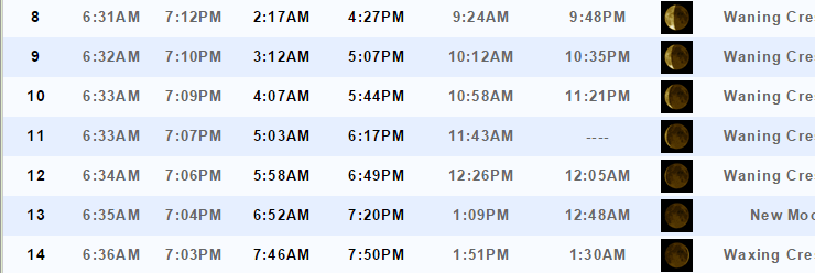
Sunrise and Sunset Times – Click Here

Don’t forget to check out the Southern Illinois Weather Observatory web-site for weather maps, tower cams, scanner feeds, radars, and much more! Click here

An explanation of what is happening in the atmosphere over the coming days…
Highlights
1. Cool weather will continue for a couple of days
2. Perhaps some patchy fog during the overnight hours
3. We start to warm up again Tuesday onward
4. Above normal temperatures will return this week
5. Watching for a system late in the week. Low confidence
Well, the cool weather, that I have been talking about for awhile, has arrived! I am sure you noticed the difference in the air mass. Lower dew points. Lower temperatures. Temperatures are a good 20-30 degrees cooler than a few days ago. We were in the lower to middle 90’s on Tuesday. Now we are barely reaching 70 degrees for a high temperature. Now that is what I call a cold front!
The bad news is that I don’t have any significant rain in the forecast through at least Wednesday. Some of you once again missed out on measurable rainfall from this front. That makes two big misses in a span of three days. Some of you picked up rainfall on Friday. Others remained dry.
I was hoping this event would be a bit more widespread. But, par for the course. It seems we just can’t win over some of our local counties. It is dry.
These last two systems performed better for southeast Missouri and southern Illinois. Indiana and Kentucky, at least for many, have under-performed. We need rain. Fire season is upon us and without significant moisture it could become an issue as we enter the fall months.
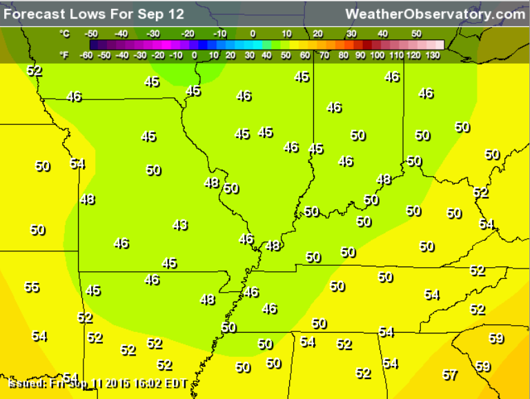
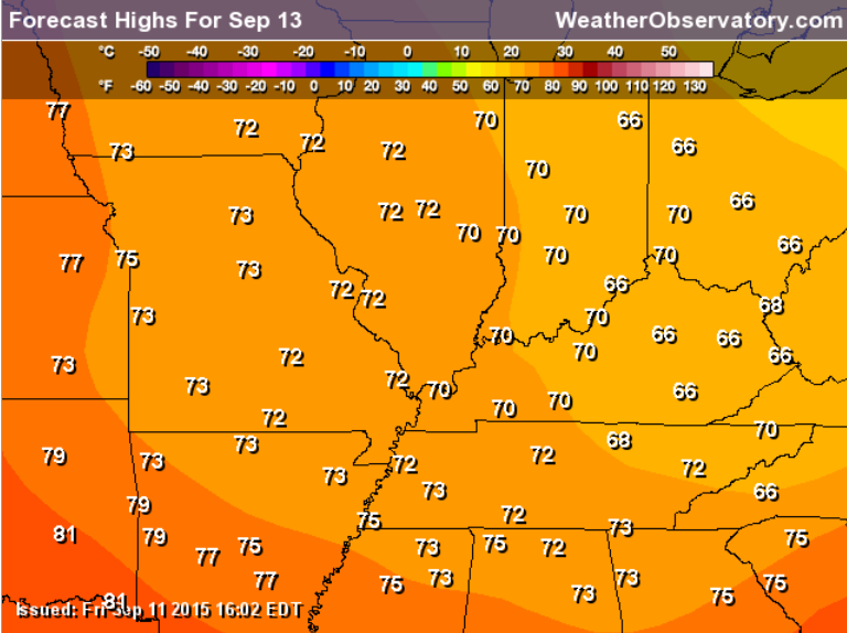
Sunday morning low temperature map
Sunday afternoon high temperature map
We do have a couple of systems over the next few weeks that I am monitoring. Hopefully one of them will produce a widespread rain event. Our other hope would be some sort of tropical system coming up from the southwest or south. Of course we don’t want anything significant along the Gulf of Mexico. Often times in September and October, however, we do find ourselves benefiting from tropical rains. But, for now…that is not the case.
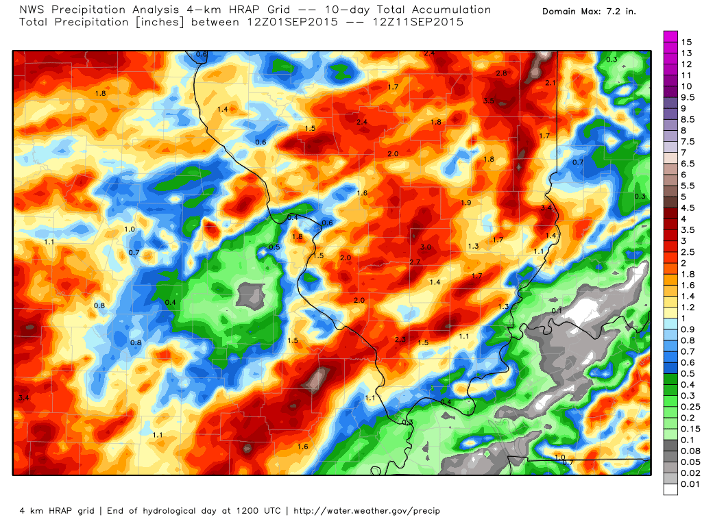
A couple of maps for you. I want to show you the difference between Missouri/Illinois vs Kentucky and Indiana when it comes to rainfall.
You can click on the images to enlarge them. This image is from weatherbell.com
Look at the big rain totals since September 1st across parts of our region. Then look at how dry it has been elsewhere. Some of our local counties have barely received measurable rainfall this month. The scale is on the right side of the page.
The grey colors represent almost no rainfall. Parts of southern Illinois and southeast Missouri have received 1-3″ of rain since September 1st. Even some pockets of greater than 4 inches of rain. Parts of southern Indiana and western Kentucky have received almost no rainfall.
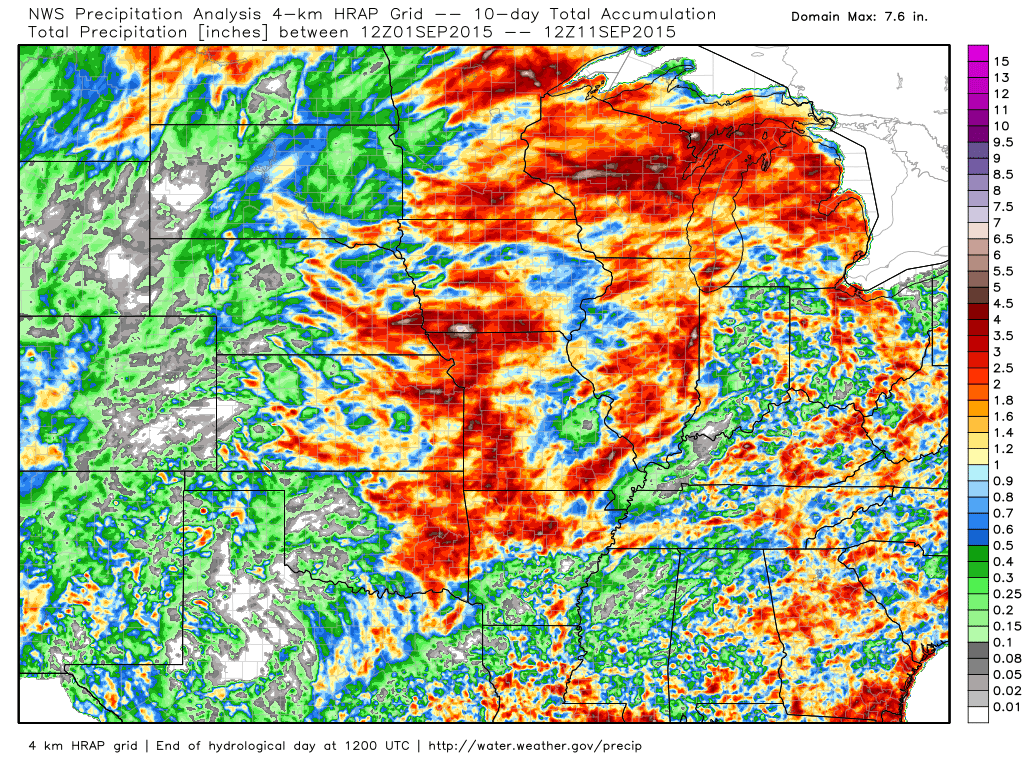
Now, let me zoom out a bit to a regional view.
Let’s hope the pattern shifts.
My September forecast was for more above normal temperature days than below normal. And, drier than normal. We still have a couple of weeks left in the month. Let’s see how it goes. So far we have had about 10 days with above normal temperatures.
Expect above normal temperatures to return by Wednesday and Thursday of this week. We may be well into the 80’s again by the end of the week (Thursday onward). Some of the temperature forecasts will depend on cloud cover and possible thunderstorms on Thursday and Friday. High confidence that we will see temperatures return to 84 and above. Low confidence on the rain and storms. I will continue to monitor.
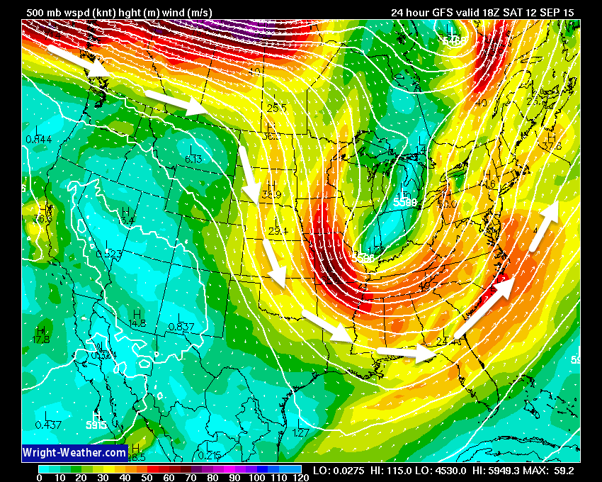
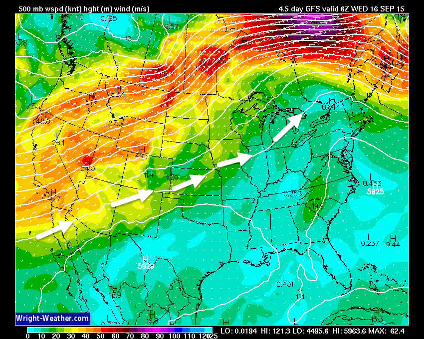
Look at the 500 mb wind fields. This is 18,000′ above the surface. See the big trough over our region on the first map? Jet stream is diving down from Canada. Thus, the cooler air mass. But, look at the second chart. See how the winds are from the southwest towards the middle of the new work week? Warmer air moving back into our region. Jet stream returns north. Images are from wright-weather.com
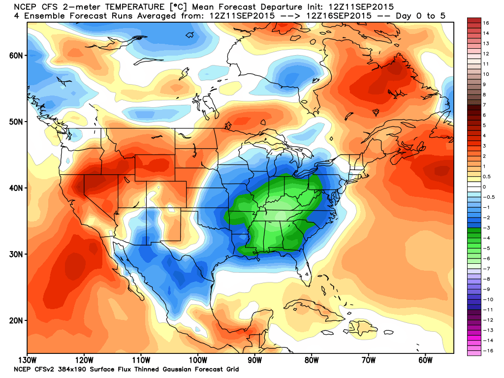
Let’s take a look at some model forecasts for temperature anomalies over the next few weeks. Will temperatures average above or below normal?
Normal highs are around 84 degrees. Normal lows are around 60 degrees.
Images are from weatherbell.com and you may click the image for a larger view.
Check out this map. This is for September 11th through the 16th. When you average the temperatures out they should be well below normal. This is especially true for September 11th through the 14th. Those green colors are well below normal temperatures. But, wait!
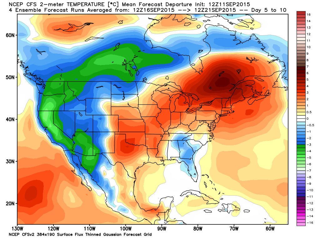
Now let’s take a look at the middle and end of this coming week. Wow, what a change. A flip occurs. The red colors represent above normal temperatures. This is for September 16th through the 21st.
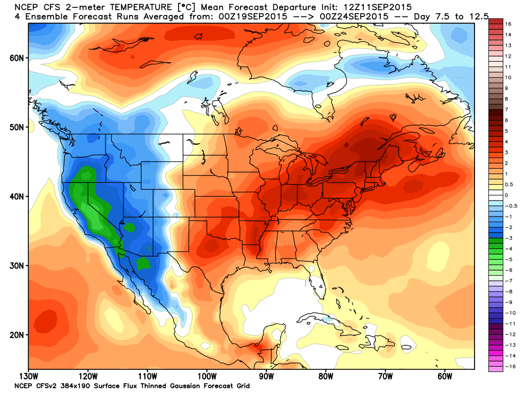
Moving ahead a bit more. This is for September 19th through the 24th. Above normal temperatures according to this model. Warm weather is not over. Summer holds on.
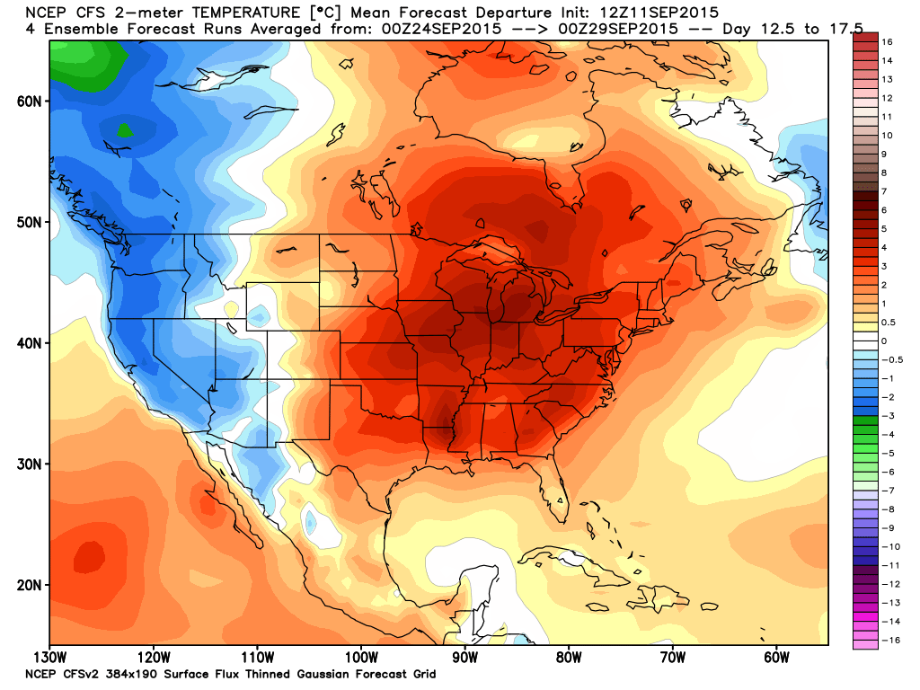
And finally September 24th through the 29th. If true then these are so big anomalies. Could we still reach 90 degrees in September? We shall see. The middle and upper 80’s are definitely on the table.
I am still watching the developing El Nino in the Pacific Ocean and the water temperatures off the northwest and west coast of the United States. These are key to the winter forecast. Also of importance will be whether or not we have a positive or negative NAO. That involves water temperatures in the northern Atlantic.
We still have to work out the long range cycle forecast. That is occurring over the coming weeks. The next 4-6 weeks. Once this pattern sets up then we can analyze what might happen in November through March. Will it be an active winter? Drought this winter? Colder or warmer than normal?
Early indications are that it will be colder than normal. I am concerned about some of the data showing dry conditions for much of the winter and early spring.
But, it is still too early to make a solid winter forecast. Still some time to go.
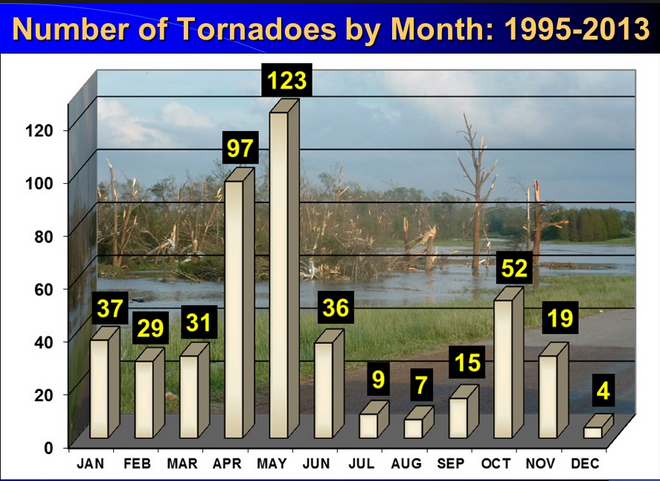
I also want to remind everyone that fall severe weather season will be here soon. Typically October and November bring a few events that need to be monitored for the potential of severe weather. Tornadoes are not uncommon in our region during October and November.
Here are the number of tornadoes per month. Note the increase in October and November.
Radars
WEATHER RADAR PAGE – Click here —
Don’t forget to support our sponsors!

How much precipitation should we expect over the next few days?
I wish I had better news on the rain front. The last two systems have not done us justice for far far southern Illinois and Kentucky. They have under-performed.
I don’t see a significant rain event through at least Wednesday. I will keep watching the system that may bring some rain chances on Thursday or Friday.
My September forecast was drier than normal. It appears to be delivering for some of us.

Can we expect severe thunderstorms over the next 24 to 48 hours? Remember that a severe thunderstorm is defined as a thunderstorm that produces 58 mph winds or higher, quarter size hail or larger, and/or a tornado.
Thunderstorm threat level will be near ZERO for Saturday and Sunday.
.
Sunday: Severe weather is not anticipated
Monday: Severe weather is not anticipated
Tuesday: Severe weather is not anticipated
Wednesday: Severe weather is not anticipated
Thursday: Severe weather is not anticipated
Friday: Severe weather is not anticipated


No major concerns on the weather front.
Calm Saturday into Monday. Can’t rule out patchy fog at times.

I also set up a storm tracking page with additional links (use during active weather for quick reference)
Storm Tracking Tool Page

Here are the current river stage forecasts. You can click your state and then the dot for your location. It will bring up the full forecast and hydrograph.
Click Here For River Stage Forecasts…
Here are some current forecast hydrographs. These will be updated each day with new information.


Smithland Lock and Dam

Paducah, Kentucky Forecast Stage

Cairo, Illinois

Cape Girardeau, Missouri
Current Temperatures Around The Local Area


We have regional radars and local city radars – if a radar does not seem to be updating then try another one. Occasional browsers need their cache cleared. You may also try restarting your browser. That usually fixes the problem. Occasionally we do have a radar go down. That is why I have duplicates. Thus, if one fails then try another one.
If you have any problems then please send me an email beaudodson@usawx.com
WEATHER RADAR PAGE – Click here —
We also have a new national interactive radar – you can view that radar by clicking here.
Local interactive city radars include St Louis, Mt Vernon, Evansville, Poplar Bluff, Cape Girardeau, Marion, Paducah, Hopkinsville, Memphis, Nashville, Dyersburg, and all of eastern Kentucky – these are interactive radars. Local city radars – click here
NOTE: Occasionally you will see ground clutter on the radar (these are false echoes). Normally they show up close to the radar sites – including Paducah.

Regional Radar – Click on radar to take you our full radar page.


Regional Radar

Live Lightning Data – zoom and pan: Click here
Live Lightning Data with sound (click the sound button on the left side of the page): Click here
I also set up a storm tracking page with additional links (use during active weather for quick reference)
Storm Tracking Tool Page
![]()
Current WARNINGS (a warning means take action now). Click on your county to drill down to the latest warning information. Keep in mind that there can be a 2-3 minute delay in the updated warning information.
I strongly encourage you to use a NOAA Weather Radio or warning cell phone app for the most up to date warning information. Nothing is faster than a NOAA weather radio.


Color shaded counties are under some type of watch, warning, advisory, or special weather statement. Click your county to view the latest information.

Missouri Warnings

Illinois Warnings

Kentucky Warnings

Here is the official 6-10 day and 8-14 day temperature and precipitation outlook. Check the date stamp at the top of each image (so you understand the time frame).
The forecast maps below are issued by the Weather Prediction Center (NOAA).


The latest 8-14 day temperature and precipitation outlook. Note the dates are at the top of the image. These maps DO NOT tell you how high or low temperatures or precipitation will be. They simply give you the probability as to whether temperatures or precipitation will be above or below normal.


Who do you trust for your weather information and who holds them accountable?
I have studied weather in our region since the late 1970’s. I have 37 years of experience in observing our regions weather patterns. My degree is in Broadcast Meteorology from Mississippi State University and an Associate of Science (AS). I am currently working on my Bachelor’s Degree in Geoscience. Just need to finish two Spanish classes!
I am a member of the American Meteorological Society. I am a NOAA Weather-Ready Nation Ambassador. And, I am the former Meteorologist for McCracken County Emergency Management. I served them proudly for ten years before expanding my job role to additional counties in western Kentucky.
I own and operate the Southern Illinois Weather Observatory.
There is a lot of noise on the internet. A lot of weather maps are posted without explanation. Over time you should learn who to trust for your weather information.
My forecast philosophy is simple and straight forward.
- Communicate in simple terms
- To be as accurate as possible within a reasonable time frame before an event
- Interact with you on Twitter, Facebook, and the blog
- Minimize the “hype” that you might see on television or through other weather sources
- Push you towards utilizing wall-to-wall LOCAL TV coverage during severe weather events
I am a recipient of the Mark Trail Award, WPSD Six Who Make A Difference Award, Kentucky Colonel, and the Caesar J. Fiamma” Award from the American Red Cross. In 2009 I was presented with the Kentucky Office of Highway Safety Award. I was recognized by the Kentucky House of Representatives for my service to the State of Kentucky leading up to several winter storms and severe weather outbreaks.
If you click on the image below you can read the Kentucky House of Representatives Resolution.

I am also President of the Shadow Angel Foundation which serves portions of western Kentucky and southern Illinois.
Many of my graphics are from www.weatherbell.com – a great resource for weather data, model data, and more


You can sign up for my AWARE email by clicking here I typically send out AWARE emails before severe weather, winter storms, or other active weather situations. I do not email watches or warnings. The emails are a basic “heads up” concerning incoming weather conditions.