

.
You must have a Weather Talk subscription ($3 a month) to view the videos.
Videos are posted on the www.weathertalk.com website. Once there, click the Beau Video-Cast tab. Long Range Video Update
If you believe you missed a video then you can also click the LIVE FEED link on the Weather Talk website. You will find the most recent and previous seven days worth of links on that page.
I can app/text you the videos, as well. Make sure you have text option FOUR turned on. That would be the Weather Extra text option. Sign up for the app/text messages, videos, and more at www.beaudodsonweather.com
.

.
This forecast update covers southern Illinois, southeast Missouri, western Kentucky. and extreme northwest Tennessee.
.
September 11, 2017
Monday Night Forecast Details:
Forecast: Increasing clouds late. Gusty winds developing. Rain developing over the Kentucky/Tennessee border counties. If rain develops it would move from the southeast towards the northwest. It will rotate into the area. Opposite of how precipitation normally moves in our region. This will be the remnants of Irma. Rain should spread towards southeast Missouri and southern Illinois. Some question as to how far northwest the rain will push. Best rain chances will be late at night.
Temperatures: MO ~ 54 to 58 IL ~ 54 to 58 KY ~ 54 to 58 TN ~ 54 to 58
Winds: North and northwest winds increasing to 15 to 30 mph. Higher gusts possible.
What impacts are anticipated from the weather? Wet roadways. Gusty winds developing.
My confidence in the forecast verifying: High.
Is severe weather expected? No
The NWS defines severe weather as 58 mph winds or great, 1″ hail or larger, and/or tornadoes
What is the chance of precipitation? MO ~ 40% IL ~ 40% KY ~ 70% TN ~ 80% (the higher rain chances arrive late at night)
Coverage of precipitation: Increasing coverage from the southeast
Should I cancel my outdoor plans? No
.
September 12, 2017
Tuesday Forecast Details
Forecast: Rain and scattered showers. Gusty winds. Cool.
Temperatures: MO ~ 66 to 74 IL ~ 66 to 74 KY ~ 66 to 74 TN ~ 66 to 74
Winds: North and northeast winds at 10 to 25 mph. Higher gusts possible.
What impacts are anticipated from the weather? Wet roadways. Gusty winds possible.
My confidence in the forecast verifying: Medium
Is severe weather expected? Unlikely, but monitor updates.
The NWS defines severe weather as 58 mph winds or great, 1″ hail or larger, and/or tornadoes
What is the chance of precipitation? MO ~ 60% IL ~ 60% KY ~ 60% TN ~ 60%
Coverage of precipitation: Numerous showers likely
Should I cancel my outdoor plans? Have a plan B
.
Tuesday Night Forecast Details:
Forecast: Mostly cloudy. Scattered rain showers.
Temperatures: MO ~ 56 to 62 IL ~ 56 to 62 KY ~ 56 to 62 TN ~ 56 to 62
Winds: Northeast winds at 10 to 20 mph. Gusty winds possible.
What impacts are anticipated from the weather? Wet roadways. Gusty winds.
My confidence in the forecast verifying: Medium
Is severe weather expected? Unlikely, but monitor updates
The NWS defines severe weather as 58 mph winds or great, 1″ hail or larger, and/or tornadoes
What is the chance of precipitation? MO ~ 50% IL ~ 50% KY ~ 50% TN ~ 50%
Coverage of precipitation: Scattered to perhaps numerous
Should I cancel my outdoor plans? Have a plan B
.
September 13, 2017
Wednesday Forecast Details
Forecast: Mostly cloudy. Some remaining showers possible. Cool. If Irma departs faster then temperatures will be a bit higher than forecast.
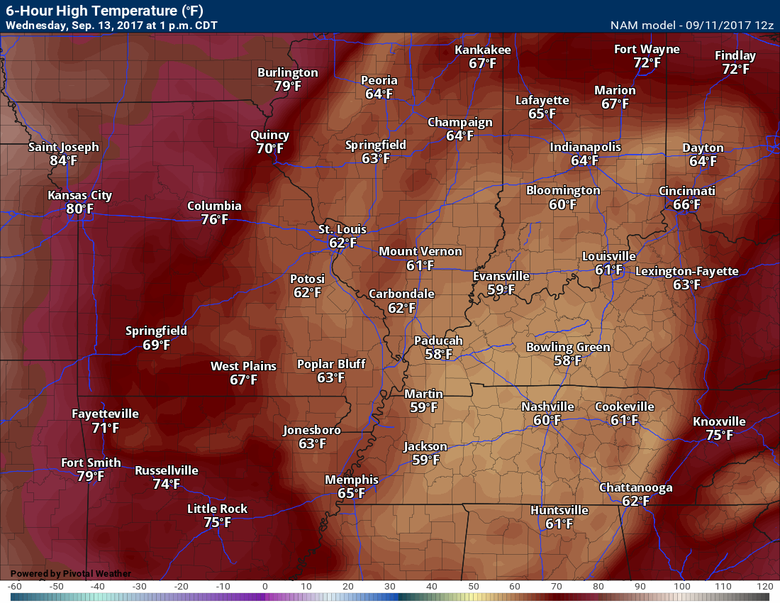
Temperatures: MO ~ 68 to 74 IL ~ 68 to 74 KY ~ 68 to 74 TN ~ 68 to 74
Winds: Southeast winds at 8 to 16 mph. Gusty winds possible.
What impacts are anticipated from the weather? Wet roadways. Gusty winds possible.
My confidence in the forecast verifying: Medium
Is severe weather expected? Unlikely
The NWS defines severe weather as 58 mph winds or great, 1″ hail or larger, and/or tornadoes
What is the chance of precipitation? MO ~ 40% IL ~ 40% KY ~ 40% TN ~ 40%
Coverage of precipitation: Scattered, but diminishing
Should I cancel my outdoor plans? Have a plan B
.
Wednesday Night Forecast Details:
Forecast: Some clouds. A chance for scattered showers. Rain should be or have ended.
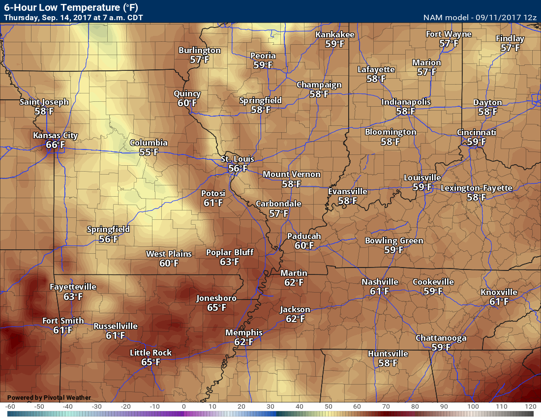
Temperatures: MO ~ 55 to 60 IL ~ 55 to 60 KY ~ 55 to 60 TN ~ 55 to 60
Winds: Variable at 6 to 12 mph
What impacts are anticipated from the weather? Perhaps wet roadways
My confidence in the forecast verifying: Medium
Is severe weather expected? No
The NWS defines severe weather as 58 mph winds or great, 1″ hail or larger, and/or tornadoes
What is the chance of precipitation? MO ~ 20% IL ~ 20% KY ~ 20% TN ~ 20%
Coverage of precipitation: Scattered
Should I cancel my outdoor plans? No, but monitor updates
.
September 14, 2017
Thursday Forecast Details
Forecast: A mix of sun and clouds. Mild.
Temperatures: MO ~ 74 to 78 IL ~ 74 to 78 KY ~ 74 to 78 TN ~ 74 to 78
Winds: Variable winds becoming northwest at 5 to 10 mph
What impacts are anticipated from the weather? Most likely none.
My confidence in the forecast verifying: Medium
Is severe weather expected? No
The NWS defines severe weather as 58 mph winds or great, 1″ hail or larger, and/or tornadoes
What is the chance of precipitation? MO ~ 0% IL ~ 0% KY ~ 0% TN ~ 0%
Coverage of precipitation: None anticipated
Should I cancel my outdoor plans? No
.
Thursday Night Forecast Details:
Forecast: Mostly clear.
Temperatures: MO ~ 55 to 60 IL ~ 55 to 60 KY ~ 55 to 60 TN ~ 55 to 60
Winds: Variable at 4 to 8 mph
What impacts are anticipated from the weather? None
My confidence in the forecast verifying: Medium
Is severe weather expected? No
The NWS defines severe weather as 58 mph winds or great, 1″ hail or larger, and/or tornadoes
What is the chance of precipitation? MO ~ 0% IL ~ 0% KY ~ 0% TN ~ 0%
Coverage of precipitation: None
Should I cancel my outdoor plans? No
.
September 15, 2017
Friday Forecast Details
Forecast: Mostly sunny. Mild.
Temperatures: MO ~ 78 to 84 IL ~ 78 to 84 KY ~ 78 to 84 TN ~ 78 to 84
Winds: South winds at 5 to 10 mph
What impacts are anticipated from the weather? Most likely none.
My confidence in the forecast verifying: Medium
Is severe weather expected? No
The NWS defines severe weather as 58 mph winds or great, 1″ hail or larger, and/or tornadoes
What is the chance of precipitation? MO ~ 0% IL ~ 0% KY ~ 0% TN ~ 0%
Coverage of precipitation: None anticipated
Should I cancel my outdoor plans? No
.
Friday Night Forecast Details:
Forecast: Mostly clear.
Temperatures: MO ~ 56 to 62 IL ~ 56 to 62 KY ~ 56 to 62 TN ~ 56 to 62
Winds: Variable winds at 5 mph
What impacts are anticipated from the weather? None
My confidence in the forecast verifying: Medium
Is severe weather expected? No
The NWS defines severe weather as 58 mph winds or great, 1″ hail or larger, and/or tornadoes
What is the chance of precipitation? MO ~ 0% IL ~ 0% KY ~ 0% TN ~ 0%
Coverage of precipitation: None
Should I cancel my outdoor plans? No
.
September 16, 2017
Saturday Forecast Details
Forecast: Mostly sunny. Mild.
Temperatures: MO ~ 80 to 85 IL ~ 80 to 85 KY ~ 80 to 85 TN ~ 80 to 85
Winds: South winds at 5 to 10 mph
What impacts are anticipated from the weather? Most likely none.
My confidence in the forecast verifying: Medium
Is severe weather expected? No
The NWS defines severe weather as 58 mph winds or great, 1″ hail or larger, and/or tornadoes
What is the chance of precipitation? MO ~ 0% IL ~ 0% KY ~ 0% TN ~ 0%
Coverage of precipitation: None anticipated
Should I cancel my outdoor plans? No
.
Saturday Night Forecast Details:
Forecast: Mostly clear.
Temperatures: MO ~ 56 to 62 IL ~ 56 to 62 KY ~ 56 to 62 TN ~ 56 to 62
Winds: Variable winds at 5 mph
What impacts are anticipated from the weather? None
My confidence in the forecast verifying: Medium
Is severe weather expected? No
The NWS defines severe weather as 58 mph winds or great, 1″ hail or larger, and/or tornadoes
What is the chance of precipitation? MO ~ 0% IL ~ 0% KY ~ 0% TN ~ 0%
Coverage of precipitation: None
Should I cancel my outdoor plans? No
.

Don’t forget to check out the Southern Illinois Weather Observatory web-site for weather maps, tower cams, scanner feeds, radars, and much more! Click here
.

A severe thunderstorm is defined as a storm that produces quarter size hail or larger, 58 mph winds or greater, and/or a tornado. That is the official National Weather Service definition of a severe thunderstorm
Monday night through Wednesday night: The remnants of Hurricane Irma will push into our region. At this time, the tornado threat appears low. Locally heavy rain is possible with Irma, but widespread heavy rain or flash flooding is not anticipated. Most of the area needs rain.
Gusty winds will occur on Monday night and Tuesday. Some gusts could top 30 or perhaps even 40 mph.
Southcentral Kentucky experienced heavy rain from Harvey. Those areas could have some water issues if heavy rain develops. Monitor updates.
.

Overview
Are there any weather concerns
- Irma spreading rain and gusty winds into the region
- Below normal temperatures to continue
Short range
Confidence level in the short range forecast is high
Look at the size of Irma. Amazing. We are fortunate that we are not anticipating anything worse than gusty winds and some rain.
Click images to enlarge.

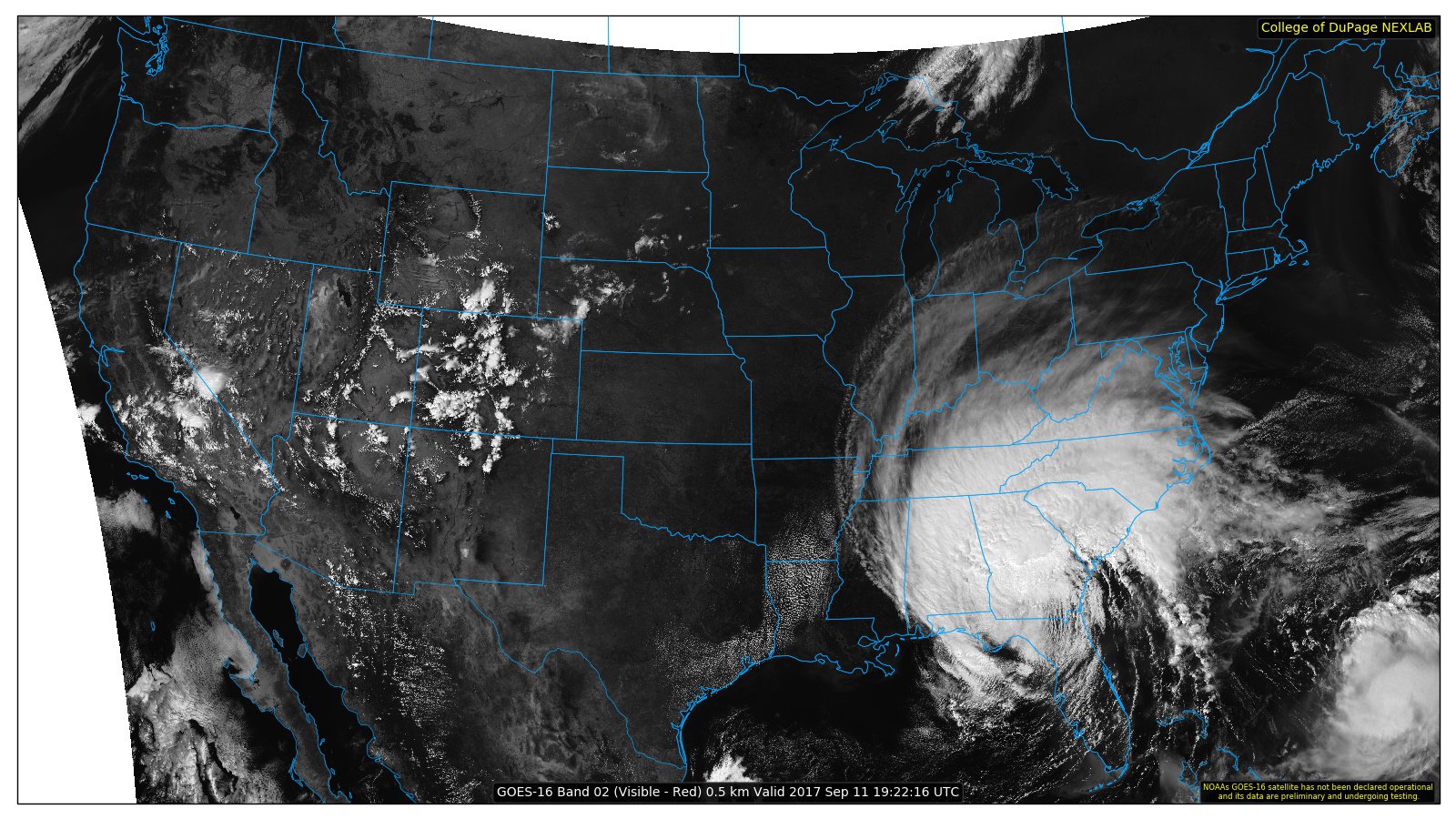
Harvey and Irma have wrecked havoc on many areas across the United States. Both produced extreme damage. Harvey dropped heavy rain into our region and now Irma will approach from the south and east.
The good news is that Irma should not produce flash flooding or extreme weather in our local area.
We will have gusty winds developing late tonight (Monday night) and those winds will continue into Tuesday. Right now, it appears that winds of 15 to 25 mph will be the general rule. I can’t rule out higher gusts, but widespread higher numbers seem unlikely.
The strongest winds should arrive late tonight into Tuesday morning.
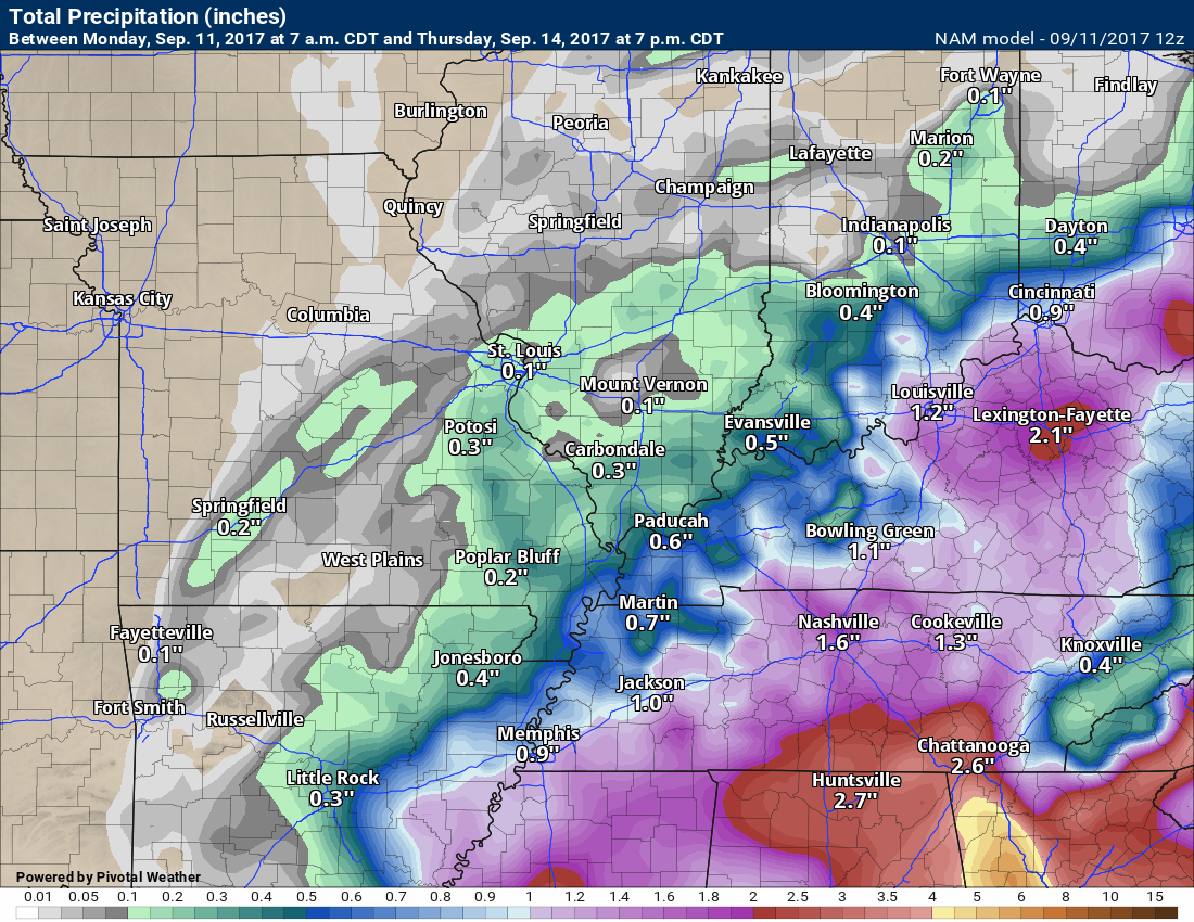
Rain will also overspread portions of the area later tonight and those rain chances will linger into Wednesday. It is possible that portions of the area receive very little in the way of measurable rainfall.
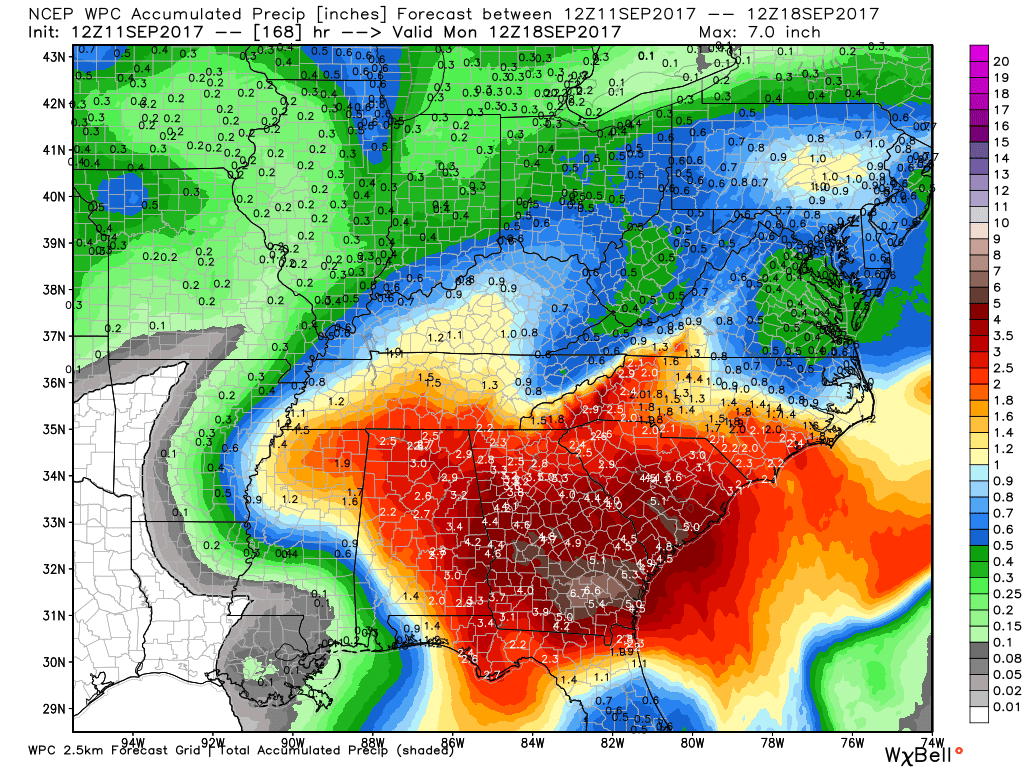
See the rainfall forecast totals below.
The highest totals should be over Kentucky and Tennessee. Lesser totals as you move further and further west and north.
That means that Murray, Kentucky will have more rain than Farmington, Missouri.
Models differ in their totals, but not by much. There is a general consensus that totals will mostly range from 0.40″ to 0.80″ and then pockets of one inch or more.
Here is the official WPC NOAA rainfall outlook.
Notice how the numbers are higher over our southeast counties vs northwest.
Click image to enlarge
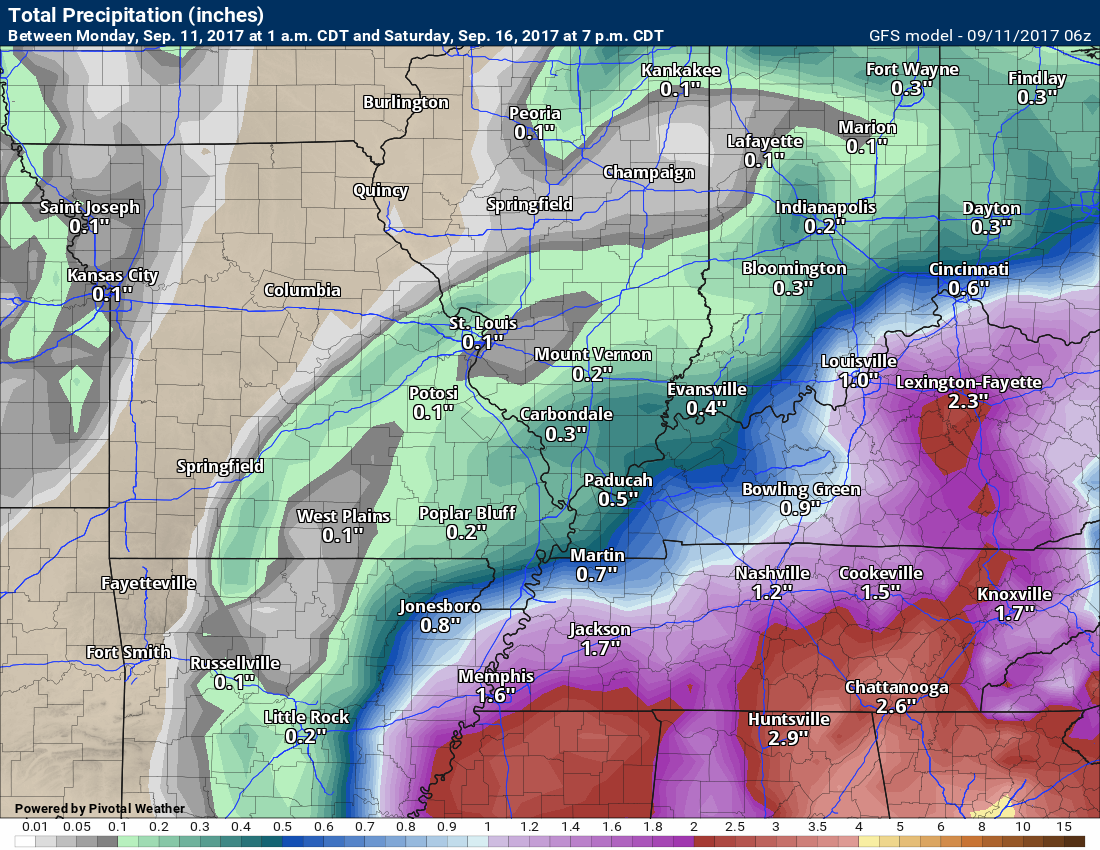
The GFS model guidance rainfall forecast (below)
The Canadian computer model

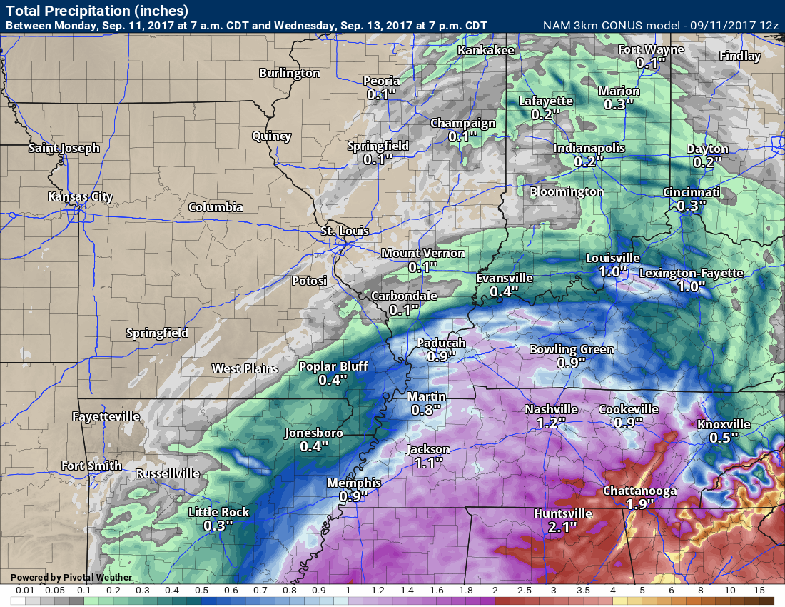
The NAM 3K model guidance
The NAM model guidance (the lower resolution one)
The rain chances will linger into Wednesday, but I am expecting mostly scattered showers by Tuesday night and Wednesday.
The best rain chances will be tonight (Monday night) and then Tuesday into Tuesday evening.
Temperatures will be cooler than normal, because of the rain and thick clouds (at least over most of the area).
Looking further ahead
We may warm up a little bit on Friday, Saturday, and Sunday. Perhaps lower to middle 80’s all three days.
Normal high temperatures are around 84/85 degrees. We may move back towards normal temperatures. Perhaps a few degrees above normal.
I continue to watch a cold front around the 16th/17th/18th. Long way out, but monitoring it.
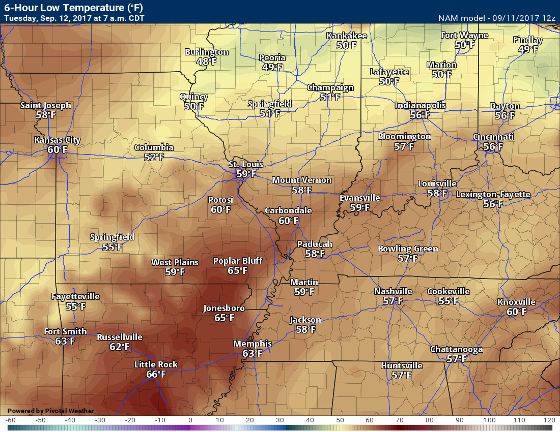
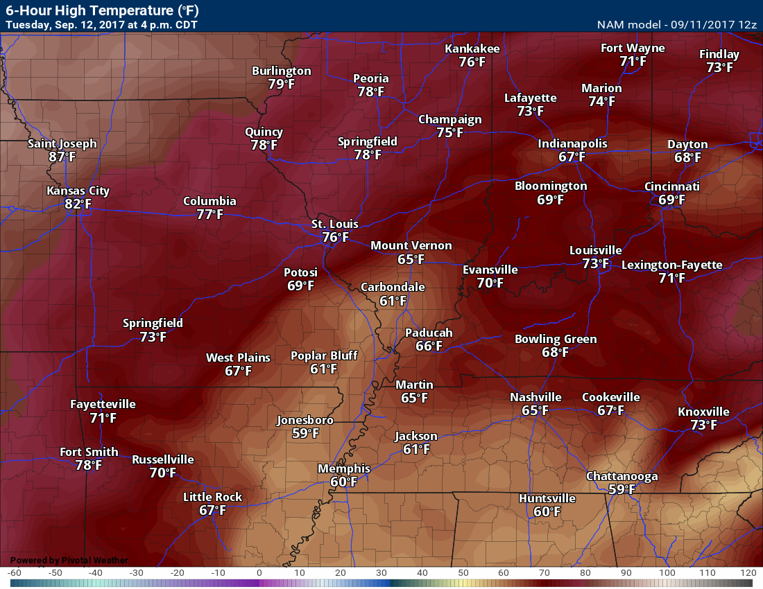
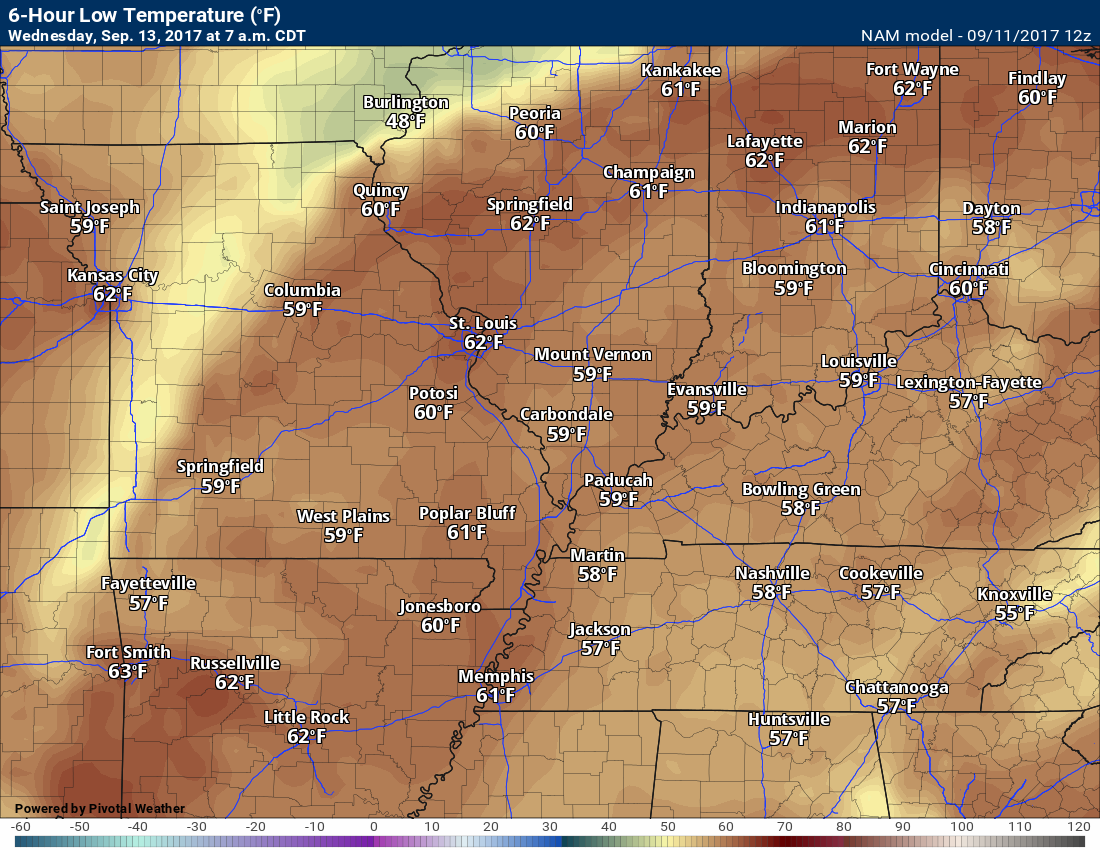
TEMPERATURE FORECAST
Temperatures will be well below normal as Irma approaches our region. Thick clouds and rain will be the cause.
Click images to enlarge
Low temperatures for Monday night (below)
High temperatures for Tuesday (below)
Low temperatures for Tuesday night (below)
High temperatures for Wednesday
Low temperatures for Wednesday night
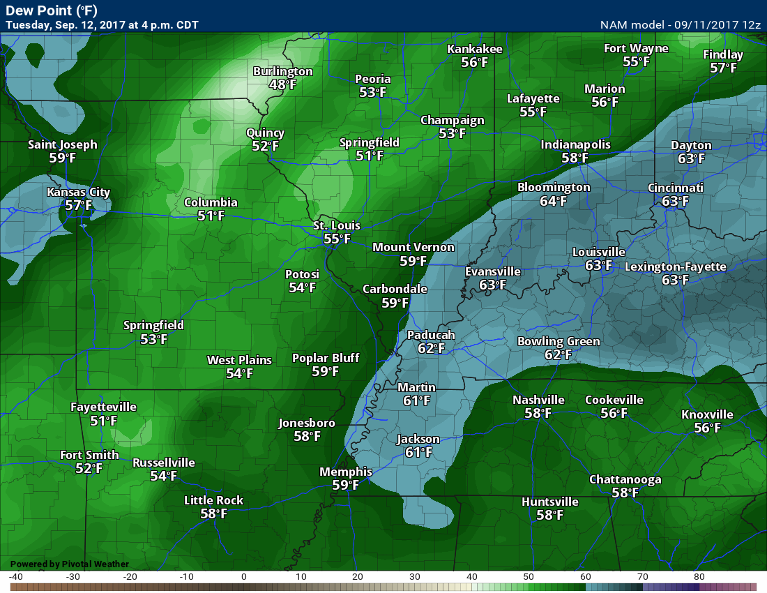
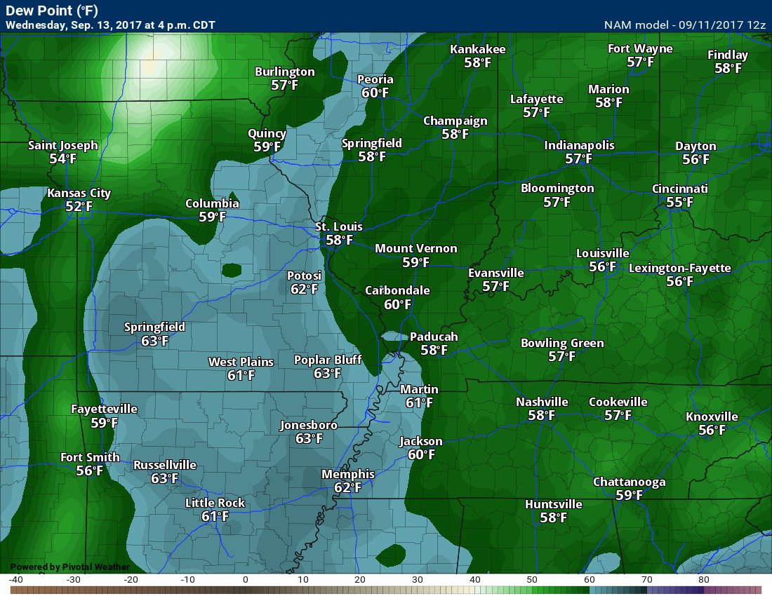
Dew point scale

Dew points for Tuesday
Dew points for Wednesday
Dew points for Thursday

Long range
The confidence level is medium for the long range forecast.
We should dry out Thursday through Sunday and temperatures will move closer to normal. Highs by Friday into Sunday should rise into the lower to middle 80’s. Closer to normal for this time of the year.
All four days should remain dry.
Are you subscribing to the Weather Talk texts and videos?
We now have premiere videos for the short and long range forecasts! Make sure you have text option four turned on (green).
Sign up at www.beaudodsonweather.com
We also have an Apple and Android app (scroll down to bottom of the page for more information)

Were you aware that I have hired some help for long range videos? Short range videos, as well. An amazing team of meteorologists.
Click the link below to read more
http://cms.weathertalk.com/meet-the-team/
Weather Talk subscribers now have some of the best short and long range weather videos produced across the eastern United States.
.


We have regional radars and local city radars – if a radar does not update then try another one. Occasional browsers need their cache cleared. You may also try restarting your browser. That usually fixes the problem. Occasionally we do have a radar go down. That is why I have duplicates. Thus, if one fails then try another one.
During the winter you can track snow and ice by clicking the winterize button on the local city view interactive radars.
If you have any problems then please send me an email beaudodson@usawx.com
Interactive Weather Radar Page. Choose the city nearest your location: Click this link
National interactive radar: Click this link.
Local interactive city radars include St Louis, Mt Vernon, Evansville, Poplar Bluff, Cape Girardeau, Marion, Paducah, Hopkinsville, Memphis, Nashville, Dyersburg, and all of eastern Kentucky. These are interactive radars. Local city radars – click here
The Beau Dodson Weather APP is ready for Apple and Android users. The purpose of this app is for me to deliver your app/text messages instantly. ATT and Verizon have not always been reliable when it comes to speed. The app allows instant delivery.
Some of you have asked if you can receive the texts on your phone and the app. The answer to that is, yes. The Android app will automatically allow that to happen. On the Apple app, however, you will need to go into your app and click settings. Make sure the green tab is OFF. Off means you will still receive the texts to your phone and the app. If you have any questions, then email me at beaudodson@usawx.com
The app is for text subscribers.
The direct download, for the Apple app, can be viewed here
https://itunes.apple.com/us/app/id1190136514
If you have not signed up for the texting service then you may do so at www.beaudodsonweather.com

The Android app is also ready.
Remember, the app’s are for www.weathertalk.com subscribers. The app allows your to receive the text messages faster than ATT and Verizon.
Here is the download link for the Android version Click Here

——————————————————–
If you have not signed up for the texts messages, then please do. Link www.beaudodsonweather.com
Your support helps with the following:

and


Who do you trust for your weather information and who holds them accountable?
I have studied weather in our region since the late 1970’s. I have 39 years of experience in observing our regions weather patterns. My degree is in Broadcast Meteorology and a Bachelor’s of Science.
My resume includes:
Member of the American Meteorological Society.
NOAA Weather-Ready Nation Ambassador.
Meteorologist for McCracken County Emergency Management. I served from 2005 through 2015.
Meteorologist for McCracken County Rescue. 2015 through current
I own and operate the Southern Illinois Weather Observatory.
I am the chief meteorologist for Weather Talk LLC. I am the owner of Weather Talk LLC.
I am also a business owner in western Kentucky.
Recipient of the Mark Trail Award, WPSD Six Who Make A Difference Award, Kentucky Colonel, and the Caesar J. Fiamma” Award from the American Red Cross.
In 2005 I helped open the largest American Cross shelter in U.S. history in Houston, Texas. I was deployed to help after Hurricane Katrina and Hurricane Rita. I was a shelter manager of one of the Houston, Texas shelter divisions.
In 2009 I was presented with the Kentucky Office of Highway Safety Award.
Recognized by the Kentucky House of Representatives for my service to the State of Kentucky leading up to several winter storms and severe weather outbreaks.
If you click on the image below you can read the Kentucky House of Representatives Resolution.

I am also President of the Shadow Angel Foundation which serves portions of western Kentucky and southern Illinois.
There is a lot of noise on the internet. A lot of weather maps are posted without explanation. Over time you should learn who to trust for your weather information.
My forecast philosophy is simple and straight forward.
- Communicate in simple terms
- To be as accurate as possible within a reasonable time frame before an event
- Interact with you on Twitter, Facebook, email, texts, and this blog
- Minimize the “hype” that you might see on some television stations or through other weather sources
- Push you towards utilizing wall-to-wall LOCAL TV coverage during severe weather events
Many of the graphics on this page are from www.weatherbell.com
WeatherBell is a great resource for weather model guidance.


You can sign up for my AWARE email by clicking here I typically send out AWARE emails before severe weather, winter storms, or other active weather situations. I do not email watches or warnings. The emails are a basic “heads up” concerning incoming weather conditions