We have some great sponsors for the Weather Talk Blog. Please let our sponsors know that you appreciate their support for the Weather Talk Blog.
Milner and Orr Funeral Home and Cremation Services located in Paducah, Kentucky and three other western Kentucky towns – at Milner and Orr they believe in families helping families. You can find Milner and Orr on Facebook, as well.
![]()
.

Wortham Dental Care located in Paducah, Kentucky. The gentle dentist. Mercury free dentistry. They also do safe Mercury removal. You can find Wortham Dental Care on Facebook, as well
.

Trover’s Equipment and Lawn Care – Family owned and operated! They are a dealer for Snapper, Simplicity, Snapper Pro, Bad Boy Mowers, and Intimidator Utility Vehicles. They are a Stihl and Dolmar power products dealer. They also are a dealer for Briggs & Stratton, Kohler gas & diesel engines, and Kawasaki engines. They service and repair just about any brand. You can find them on Facebook, as well
.

Visit their web-site here. Or, you can also visit their Facebook page.
.

Endrizzi’s Storm Shelters – For more information click here. Endrizzi Contracting and Landscaping can be found on Facebook, as well – click here
.
Are you looking for a full service insurance agency that writes homes, businesses, and vehicles in Illinois, Kentucky, and Tennessee. Call Gary’s office at 270.442.8234 for rates and plans to protect what matters to you!

Gary Eckelkamp’s web-site click the above banner or click here
.

This forecast update covers far southern Illinois, far southeast Missouri, and far western Kentucky. See the coverage map on the right side of the blog.
Remember that weather evolves. Check back frequently for updates, especially during active weather.
The forecast numbers below may vary a bit across the region. These are the averages.
WEATHER RADAR PAGE – Click here —
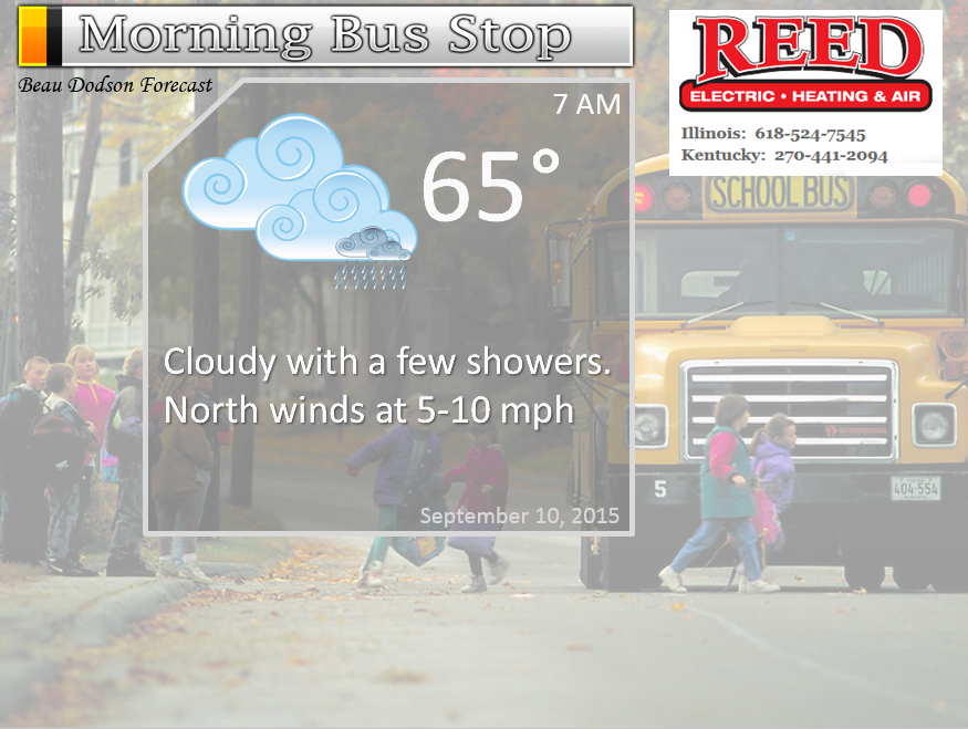
Wednesday night – Cloudy. Patchy fog possible. A chance for showers and maybe a rumble of thunder.
Temperatures: Lows in the middle 60’s
Winds: South/southwest winds at 5-10 mph possible becoming northwest as a front moves through the region
My confidence in this part of the forecast verifying is high
Should I cancel my outdoor plans? Perhaps. Some rain is expected.
Is severe weather expected? No
What is the chance for precipitation? 40%-60% (mainly early). Not everyone will pick up rainfall.
What impact is expected? Some showers. Maybe a rumble of thunder.
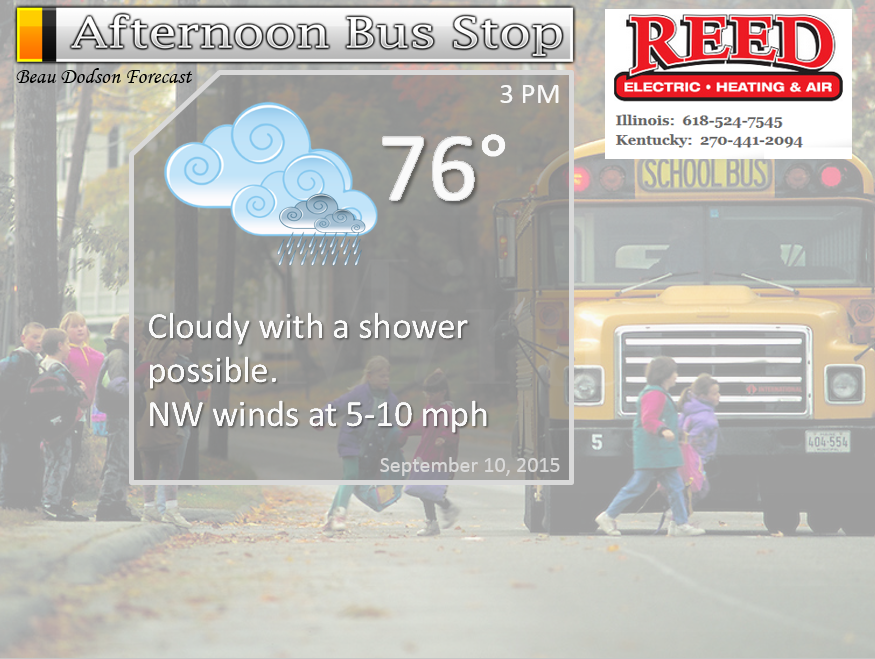
Thursday – Patchy morning fog possible. Sunny at times. Patchy clouds with a small chance for a shower over southeast Missouri and eastern counties of west Kentucky. Most will remain dry on Thursday.
Temperatures: Highs in the lower 80’s
Winds: Northwest and north winds at 5-10 mph with gusts to 15 mph.
My confidence in this part of the forecast verifying is high
Should I cancel my outdoor plans? No
Is severe weather expected? No
What is the chance for precipitation? 10%
What impact is expected? No major impacts.
Thursday night – Decreasing clouds early and then increasing clouds late. A chance for some showers moving in from the northwest.
Temperatures: Lows in the lower 60’s
Winds: North and northwest winds at 5 mph
My confidence in this part of the forecast verifying is medium
Should I cancel my outdoor plans? No
Is severe weather expected? No
What is the chance for precipitation? 10%-20% early and then increasing to 40%-60% by Friday morning.
What impact is expected? Nothing major
Friday – Becoming cloudy with a chance for some showers and rain as a second cold front sweeps through the region. Perhaps a rumble of thunder.
Temperatures: Highs in the upper 70’s to around 80 degrees.
Winds: North/northwest winds at 5-10 mph. Gusts to 15 mph.
My confidence in this part of the forecast verifying is medium
Should I cancel my outdoor plans? No, but a few showers are possible as the second cold front arrives.
Is severe weather expected? No
What is the chance for precipitation? 40%-60% chance
What impact is expected? Some rain and maybe a rumble of thunder. No severe weather.
Friday night – Partly to mostly cloudy with some lingering showers possible. Much cooler.
Temperatures: Lows in the middle 50’s
Winds: North/northwest winds at 5-10 mph perhaps some gusts to 15 mph at times.
My confidence in this part of the forecast verifying is high
Should I cancel my outdoor plans? No, but maybe some showers around.
Is severe weather expected? No
What is the chance for precipitation? 20%-30% for an evening shower
What impact is expected? Nothing major
Saturday – Some clouds. Windy at times. A chance for a few light showers. Nice temperatures. Low humidity.
Temperatures: Highs in the upper 60’s to lower 70’s. Perhaps a few middle 70’s far south.
Winds: North/northwest winds at 5-10 mph with gusts to 2o mph.
My confidence in this part of the forecast verifying is LOW
Should I cancel my outdoor plans? No, but maybe a couple of light showers in the area.
Is severe weather expected? No
What is the chance for precipitation? 30% chance
What impact is expected? No real problems.
Saturday night – Nice. Fall like. Mostly clear. Great camping weather or great weather to sleep with the windows open.
Temperatures: Lows in the upper 40’s north to lower 50’s elsewhere
Winds: North/northwest winds at 5-10 mph. Gusts to 15 early in the evening.
My confidence in this part of the forecast verifying is high
Should I cancel my outdoor plans? No
Is severe weather expected? No
What is the chance for precipitation? 0%
What impact is expected? None
Sunday – Mostly sunny. Some fair weather cumulus clouds possible. Beautiful. Low humidity levels.
Temperatures: Highs in the lower to middle 70’s
Winds: North winds at 5-10 mph becoming variable towards evening.
My confidence in this part of the forecast verifying is high
Should I cancel my outdoor plans? No
Is severe weather expected? No
What is the chance for precipitation? 0%
What impact is expected? None
Sunday night – Mostly clear. Cool.
Temperatures: Lows in the upper 40’s north to lower 50’s elsewhere
Winds: Southeast and variable winds at 5-10 mph.
My confidence in this part of the forecast verifying is high
Should I cancel my outdoor plans? No
Is severe weather expected? No
What is the chance for precipitation? 0%
What impact is expected? None
Monday – Mostly sunny and nice. Great weather.
Temperatures: Highs in the middle 70’s
Winds: Southerly winds at 5-10 mph
My confidence in this part of the forecast verifying is high
Should I cancel my outdoor plans? No
Is severe weather expected? No
What is the chance for precipitation? 0%
What impact is expected? None
Maybe another shot at rain towards the middle and end of next week.
The School Bus Stop Forecast is sponsored by Reed Electric, Heating & Air in Metropolis, IL offers full electrical, heating, and air conditioning services, as well as automatic transfer generators. Our licensed and insured service technicians serve Southern Illinois and Western KY with 24 hour service. Free estimates available for all new installations!
Click their ad below to visit their web-site or click here reedelec.com

![]()
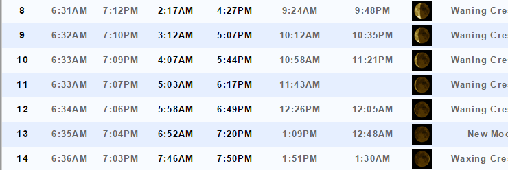
Sunrise and Sunset Times – Click Here

Don’t forget to check out the Southern Illinois Weather Observatory web-site for weather maps, tower cams, scanner feeds, radars, and much more! Click here

An explanation of what is happening in the atmosphere over the coming days…
Highlights
1. First cold front is moving through the area
2. Second cold front arrives on Friday
3. Some additional rain showers will be possible on Thursday and Friday. What about Saturday?
4. Cooler weather arriving and will last into early next week.
Our long awaited cold front has been pushing through the region over the last 12-24 hours.
Some of you picked up a lot of rain on Tuesday night and Wednesday morning. The thinking was that the band of rain would not move much eastward Tuesday night. And, it didn’t. It poured and poured on some counties. Radar actually indicated more than 5″ of rain over parts of southeast Missouri.
Here is the rainfall estimates for Tuesday nights via the Paducah, Kentucky National Weather Service Radar. The scale is on the left side of the screen. Click for a larger view.
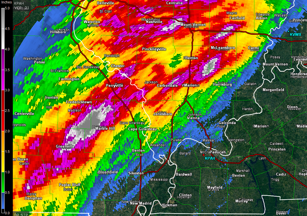
There were verified reports of 1-3.5″ over parts of southeast Missouri and southern Illinois. Sounds familiar? It should. The same thing happened quite frequently in June and July. See how patterns tend to repeat?
Unfortunately not everyone has picked up rain today. But, that was the forecast. Some could miss out. The eastern counties in the region have not picked up much rain. They need rain. We all need rain. But, just can’t seem to win in some of these counties. The forecast was for the heaviest rain to fall over MO and IL. And, that happened. Not very happy, however, about the lack of rain over the eastern half of the region.
The cold front will push through the region on Wednesday night and Thursday. This front will mark the beginning of our downward step into cooler air. A second cold front arrives on Friday. This will cause an increase in clouds and some showers on Friday. The GFS model is bringing some showers into the region as early as Friday morning. Other data indicates more like Friday afternoon and evening. I will have to monitor the timing and update accordingly. If there is an update I just change it at the top of the page with new information.
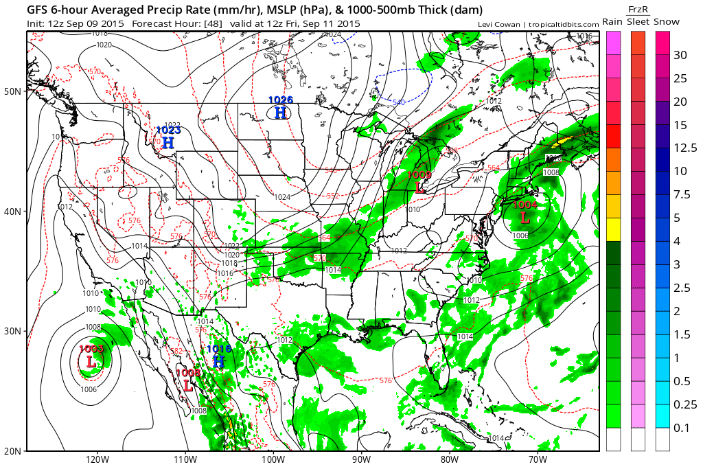
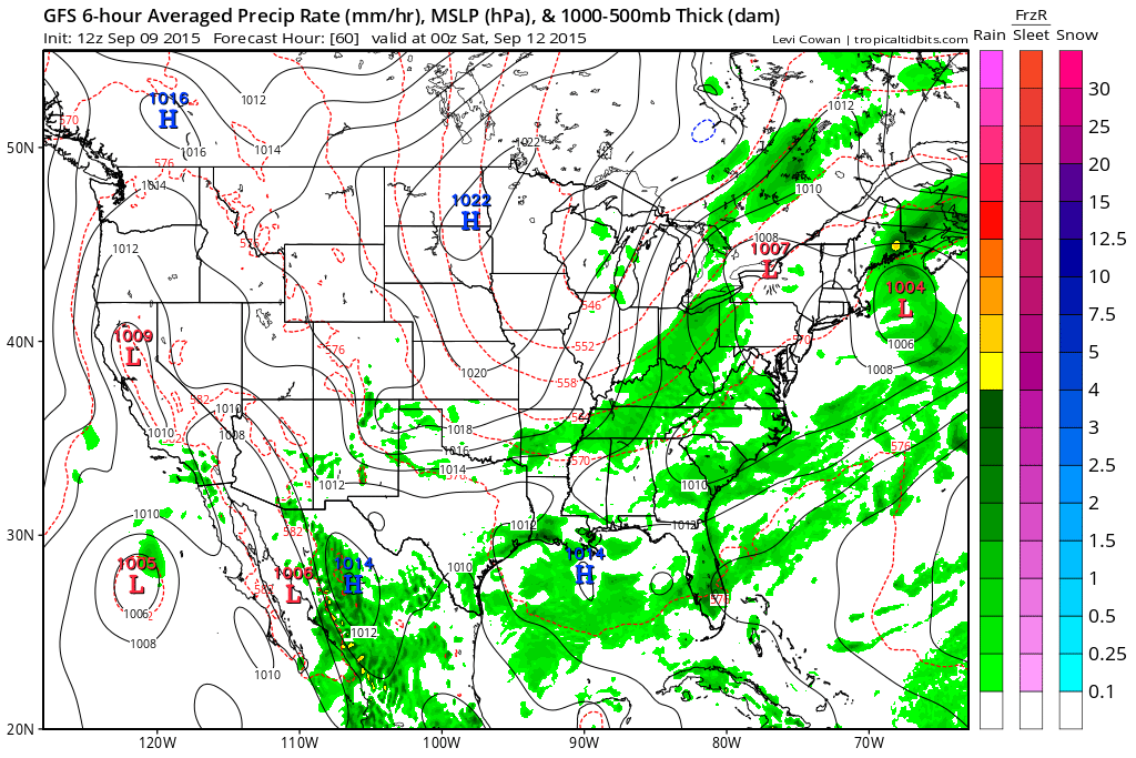
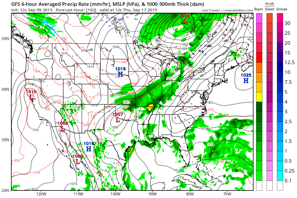
Here is the GFS graphics. Green is rain, of course.
This first graphic weather map is for Friday morning around 7 am. If the GFS is correct then we will have some showers in the region by that time.
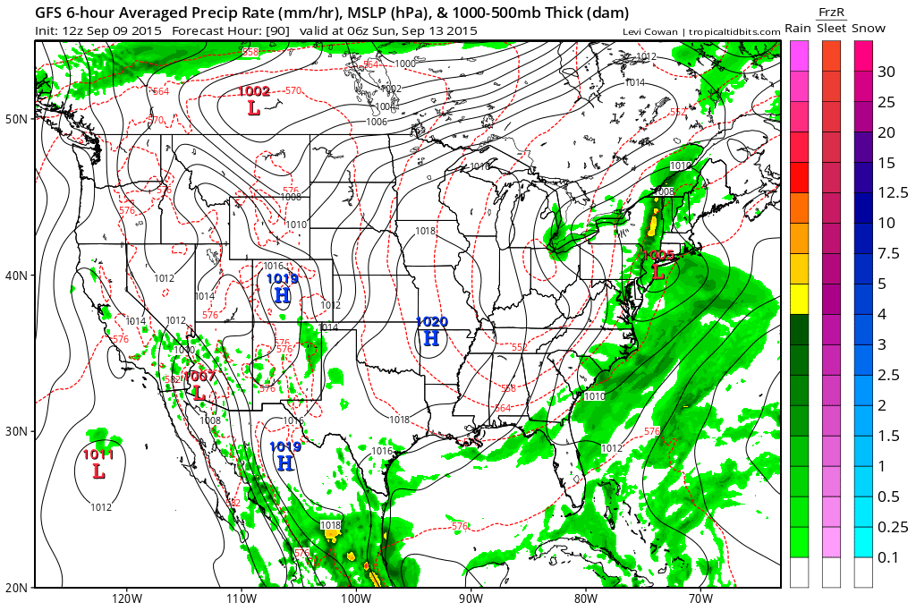
Friday around 12 pm
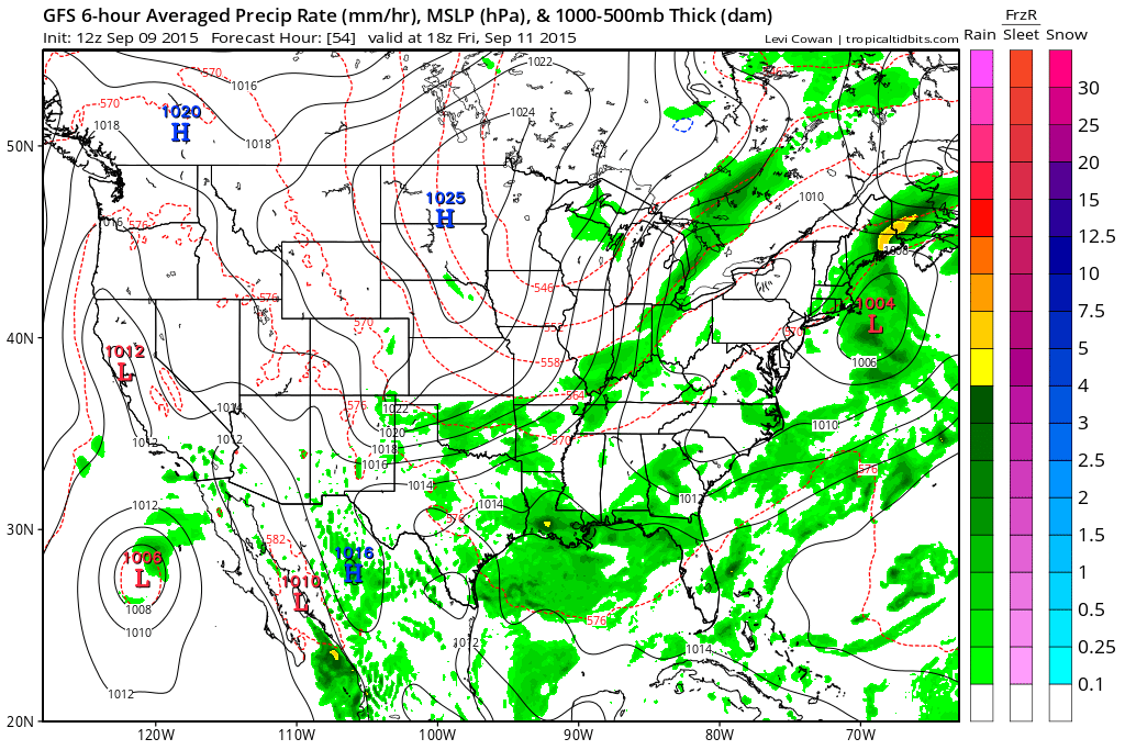
Friday afternoon/evening. Notice the rain is shifting eastward. See the big H in North and South Dakota? That is our Canadian high pressure diving southward
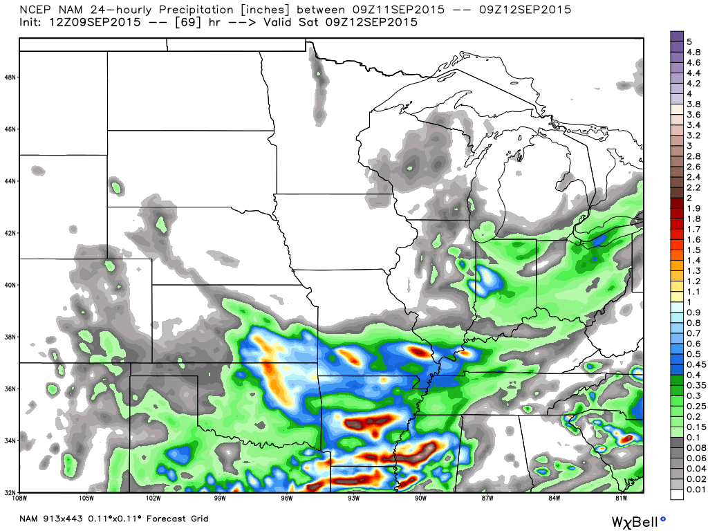
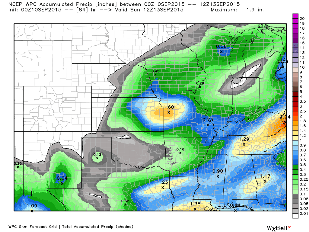
Let’s look at a map from weatherbell.com This is the rainfall totals via the NAM model for Friday. You can see it is actually painting some decent rain on Friday. Energy appears to be stronger than earlier forecast.
Is this overdone? Perhaps. We haven’t done well lately with bringing the heavier rains into Kentucky. Bottom line is that some rain is likely to occur on Friday.
Then by Saturday afternoon high pressure dominates our region. We could have some lingering showers on Saturday. Not completely sold on that idea. But, I am monitoring.
Thursday high temperatures will be in the upper 70’s to around 80 degrees. High temperatures by Friday, Saturday, and Sunday will only be in the 70’s. Overnight lows by Saturday morning will be in the 50’s. I can’t rule out some upper 40’s in rural areas and favored cold spots. Fallish? Lows in the 50’s will continue into at least Monday morning.
Some of the models are painting a few more clouds and light showers on Saturday. I will keep an eye on this. Low confidence that some energy hangs back just a little bit.
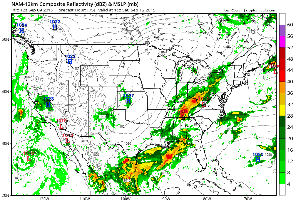
Let’s look at the NAM model for Saturday. It does have some showers in the region. I added a chance for showers into my forecast for Saturday. This was a change from earlier thinking. Low confidence and I will continue to update the top of the page as need be.
Click image for a larger view. This is for Saturday morning around 10 am. NAM and GFS both paint some light showers in the region.
Semi-gusty winds are expected Friday into Saturday. Perhaps some gusts to 20 mph on lakes and rivers. Nothing extreme, but a bit more wind than recent weeks.
The nice temperatures will last into early next week with a slow warming trend.
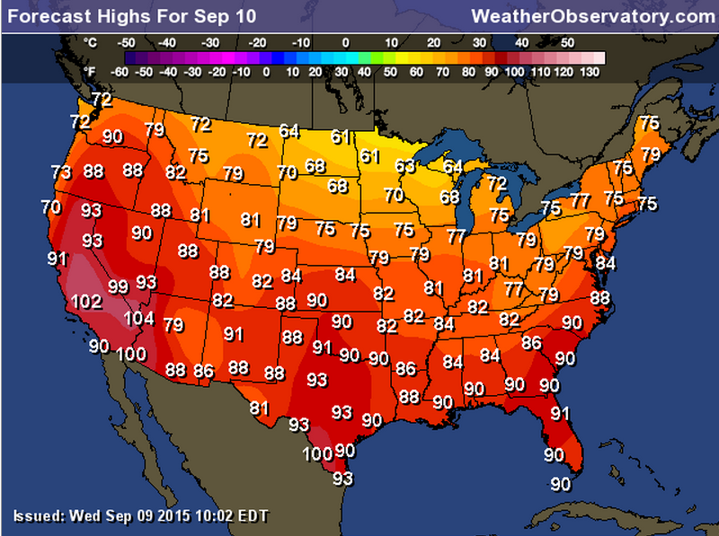
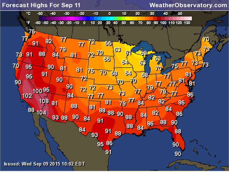
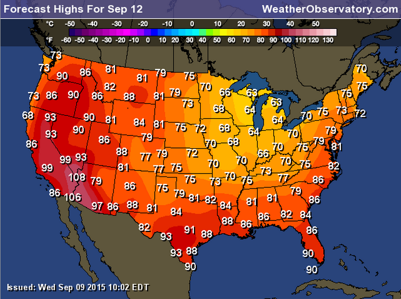
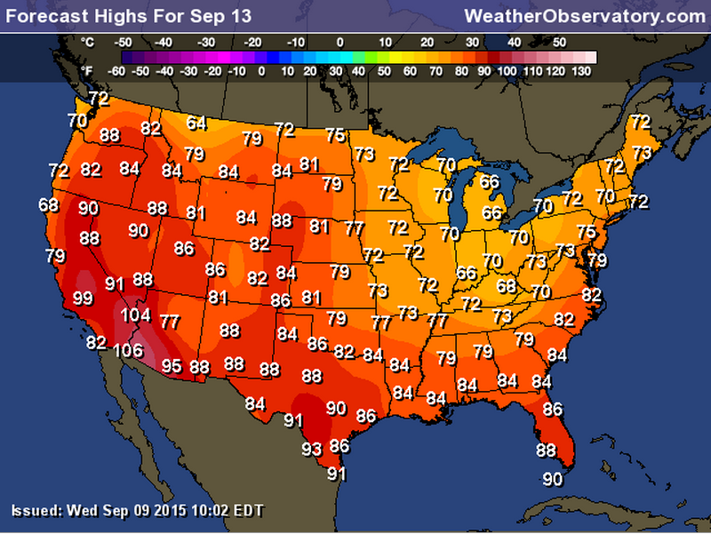
Let’s take a look at graphical temperatures for Friday into Monday. More like early fall than late summer.
Friday
Saturday
Sunday
Monday
I continue to monitor trends for the fall and winter. A lot of signals are pointing to colder than normal temperatures for October into the spring. Now, that does not mean it will be cold all of the time. It means that when you average out all of the temperatures it would average below normal.
There is a lot going on in the oceans that will impact our region. A negative NAO in the North Atlantic would be cause to consider a stormier winter. The warm waters off the West Coast would indicate a cold winter. But some data indicates the warm waters are shifting a bit westward. The central Pacific centered El Nino means a cold winter.
We still have awhile to go until I issue a winter forecast. But, I am leaning towards a colder than normal winter.
Looking at the long range models. Perhaps another storm system into the region by the middle or end of next week? Maybe. This is the GFS map for next Wednesday/Thursday.
WEATHER RADAR PAGE – Click here —
We also have a new national interactive radar – you can view that radar by clicking here.

Radars
WEATHER RADAR PAGE – Click here —
Don’t forget to support our sponsors!

How much precipitation should we expect over the next few days?
Rainfall totals from Wednesday night into Thursday will be on the light side. Especially compared to what happened on Tuesday night into Wednesday.
Showers will be more scattered on Thursday and again on Friday. Small chance on Saturday according to some data. I will monitor that.
Rainfall totals on Thursday won’t amount to much (if it rains at all).
Rainfall amounts of 0.30″-0.60″ can be expected in some locations on Friday. A second cold front arrives on Friday. This will produce some additional rain and maybe some thunderstorms. Image below is from weatherbell.com
Rainfall totals for late Thursday night and Friday

Can we expect severe thunderstorms over the next 24 to 48 hours? Remember that a severe thunderstorm is defined as a thunderstorm that produces 58 mph winds or higher, quarter size hail or larger, and/or a tornado.
Thunderstorm threat level will be near ZERO/ONE on Thursday.
.
Thursday: Thunderstorms are still possible on Thursday, as well. Mostly showers are expected. Small chance for a rumble of thunder
Friday: Severe weather is not anticipated. Small chance for a rumble of thunder on Friday.
Saturday: Severe weather is not anticipated
Sunday: Severe weather is not anticipated
Monday: Severe weather is not anticipated
Tuesday: Severe weather is not anticipated


No major weather concerns Thursday into the weekend. Just a few showers from time to time on Thursday into Friday. Maybe a few light showers on Saturday, as well.

I also set up a storm tracking page with additional links (use during active weather for quick reference)
Storm Tracking Tool Page

Here are the current river stage forecasts. You can click your state and then the dot for your location. It will bring up the full forecast and hydrograph.
Click Here For River Stage Forecasts…
Here are some current forecast hydrographs. These will be updated each day with new information.


Smithland Lock and Dam

Paducah, Kentucky Forecast Stage

Cairo, Illinois

Cape Girardeau, Missouri
Current Temperatures Around The Local Area


We have regional radars and local city radars – if a radar does not seem to be updating then try another one. Occasional browsers need their cache cleared. You may also try restarting your browser. That usually fixes the problem. Occasionally we do have a radar go down. That is why I have duplicates. Thus, if one fails then try another one.
If you have any problems then please send me an email beaudodson@usawx.com
WEATHER RADAR PAGE – Click here —
We also have a new national interactive radar – you can view that radar by clicking here.
Local interactive city radars include St Louis, Mt Vernon, Evansville, Poplar Bluff, Cape Girardeau, Marion, Paducah, Hopkinsville, Memphis, Nashville, Dyersburg, and all of eastern Kentucky – these are interactive radars. Local city radars – click here
NOTE: Occasionally you will see ground clutter on the radar (these are false echoes). Normally they show up close to the radar sites – including Paducah.
Regional Radar – Click on radar to take you our full radar page.


Regional Radar

Live Lightning Data – zoom and pan: Click here
Live Lightning Data with sound (click the sound button on the left side of the page): Click here
I also set up a storm tracking page with additional links (use during active weather for quick reference)
Storm Tracking Tool Page
![]()
Current WARNINGS (a warning means take action now). Click on your county to drill down to the latest warning information. Keep in mind that there can be a 2-3 minute delay in the updated warning information.
I strongly encourage you to use a NOAA Weather Radio or warning cell phone app for the most up to date warning information. Nothing is faster than a NOAA weather radio.


Color shaded counties are under some type of watch, warning, advisory, or special weather statement. Click your county to view the latest information.

Missouri Warnings

Illinois Warnings

Kentucky Warnings

Here is the official 6-10 day and 8-14 day temperature and precipitation outlook. Check the date stamp at the top of each image (so you understand the time frame).
The forecast maps below are issued by the Weather Prediction Center (NOAA).


The latest 8-14 day temperature and precipitation outlook. Note the dates are at the top of the image. These maps DO NOT tell you how high or low temperatures or precipitation will be. They simply give you the probability as to whether temperatures or precipitation will be above or below normal.


Who do you trust for your weather information and who holds them accountable?
I have studied weather in our region since the late 1970’s. I have 37 years of experience in observing our regions weather patterns. My degree is in Broadcast Meteorology from Mississippi State University and an Associate of Science (AS). I am currently working on my Bachelor’s Degree in Geoscience. Just need to finish two Spanish classes!
I am a member of the American Meteorological Society. I am a NOAA Weather-Ready Nation Ambassador. And, I am the former Meteorologist for McCracken County Emergency Management. I served them proudly for ten years before expanding my job role to additional counties in western Kentucky.
I own and operate the Southern Illinois Weather Observatory.
There is a lot of noise on the internet. A lot of weather maps are posted without explanation. Over time you should learn who to trust for your weather information.
My forecast philosophy is simple and straight forward.
- Communicate in simple terms
- To be as accurate as possible within a reasonable time frame before an event
- Interact with you on Twitter, Facebook, and the blog
- Minimize the “hype” that you might see on television or through other weather sources
- Push you towards utilizing wall-to-wall LOCAL TV coverage during severe weather events
I am a recipient of the Mark Trail Award, WPSD Six Who Make A Difference Award, Kentucky Colonel, and the Caesar J. Fiamma” Award from the American Red Cross. In 2009 I was presented with the Kentucky Office of Highway Safety Award. I was recognized by the Kentucky House of Representatives for my service to the State of Kentucky leading up to several winter storms and severe weather outbreaks.
If you click on the image below you can read the Kentucky House of Representatives Resolution.

I am also President of the Shadow Angel Foundation which serves portions of western Kentucky and southern Illinois.
Many of my graphics are from www.weatherbell.com – a great resource for weather data, model data, and more


You can sign up for my AWARE email by clicking here I typically send out AWARE emails before severe weather, winter storms, or other active weather situations. I do not email watches or warnings. The emails are a basic “heads up” concerning incoming weather conditions.