We have some great sponsors for the Weather Talk Blog. Please support them when you have the opportunity.
Milner and Orr Funeral Home and Cremation Services located in Paducah, Kentucky and three other western Kentucky towns – at Milner and Orr they believe in families helping families. You can find Milner and Orr on Facebook, as well.
![]()

This forecast update covers far southern Illinois, far southeast Missouri, and far western Kentucky. See the coverage map on the right side of the blog.
Remember that weather evolves. Check back frequently for updates, especially during active weather.
The forecast numbers below may vary quite a bit across the region. These are averages.
Friday Night – Freeze Alert: Cloudy. Chance for light snow over far western counties of southeast Missouri. Otherwise, flurries and light rain ending elsewhere this evening. Cold. Freeze conditions. Lows into the 20’s. North/northwest winds at 5-10 mph.
Saturday – Cold. Well below normal temperatures. Some clouds…especially early in the morning. Snow showers or snow/rain mix far western counties early in the morning. Highs will not get out of the 40’s. East/northeast winds at 5-10 mph. My confidence in this part of the forecast verifying is medium
Saturday night – Freeze Alert: Mostly clear and cold. Freeze conditions. Lows into the 20’s. Northeast winds at 5-10 mph. My confidence in this part of the forecast verifying is high
Sunday – Partly sunny early. Becoming cloudy in the afternoon. A chance for a few showers in the afternoon and even more so towards evening. Highs will be in the upper 40’s to lower 50’s. South and southwest winds at 10-20 mph. Gusty winds at times. My confidence in this part of the forecast verifying is high
Sunday night – Cloudy. A chance for light rain. South and southwest winds at 5 mph. My confidence in this part of the forecast verifying is medium
Monday – Becoming partly cloudy. Warmer. Highs into the 60’s. North winds at 10 mph. Winds may be out of the west at times. My confidence in this part of the forecast verifying is medium

Current Temperatures Around The Local Area


Don’t forget to check out the Southern Illinois Weather Observatory web-site for weather maps, tower cams, scanner feeds, radars, and much more! Click here

An explanation of what is happening in the atmosphere over the coming days…
Highlights
1. Snow tonight, Friday night…western counties of southeast Missouri. Few flurries elsewhere.
2. Freeze conditions tonight and again on Saturday night. Lows into the 20’s.
3. Rain showers possible Sunday afternoon (late) and Sunday night.
4. Warmer by Monday! More rain next week.
5. Rivers will drop dramatically over the coming week (hopefully we don’t receive a lot more rain over the coming 2 week period).
Hello, spring! Is that you spitting snowflakes, sleet, and cold rain at us today? Apparently so! Well, we knew winter wasn’t going to let go that easy.
We are not finished, in the long range, with cold weather. I see multiple cold shots over the coming weeks. I can’t promise you we won’t see 20’s again.
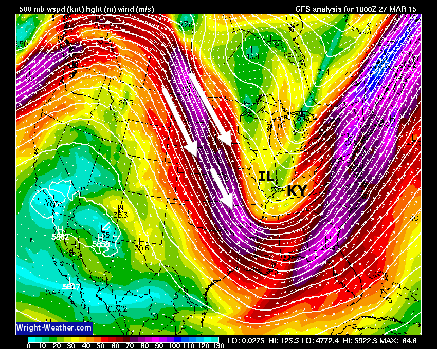
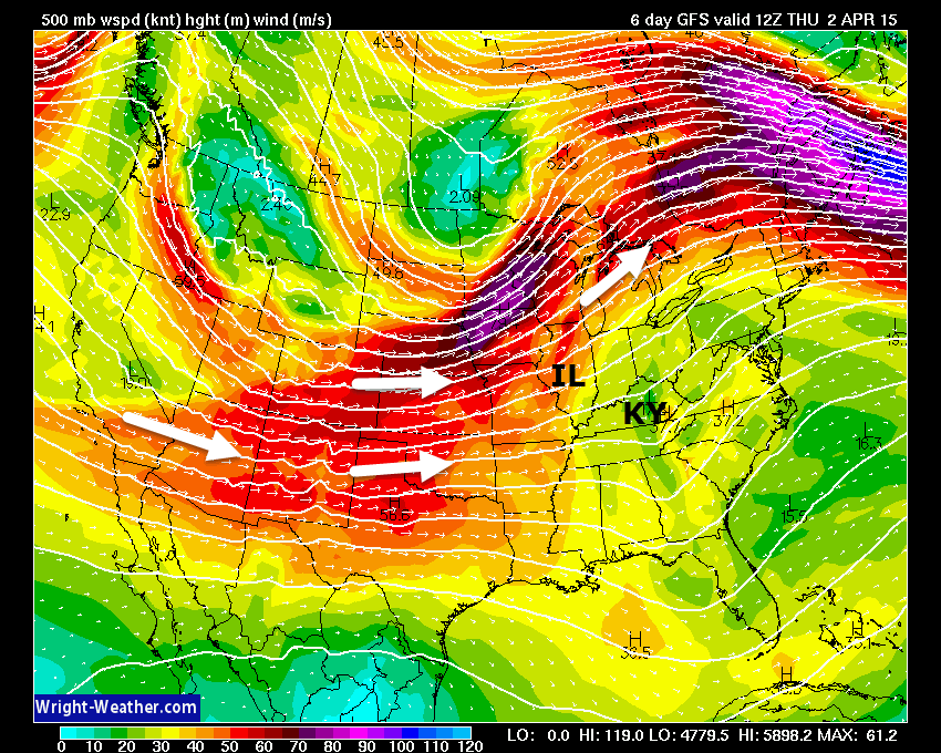
We are in a northwest flow, right now. If you remember from past blog updates…northwest flow means colder than normal weather for our region. We have been in this pattern for about 2 years now. Part of the problem is that the West Coast waters are very warm.
Here is what the northwest flow looks like on the upper level wind maps. Way up in the air. This is around the 18,000′ level. Wow, is all I can say. Good thing it isn’t January. We would be shivering. Well, shivering more than we are now.
That is a strong dip in the jet stream. Diving down from Canada. Wright-weather.com image
Tonight…
Freeze conditions for the region. Lows will dip into the 20’s. Sensitive plants should be protected.
We have a snow maker moving in from the north/northwest during the overnight hours. This system will clip our western counties. Light snow (up to a dusting) might fall over central Missouri into south central Missouri. Again, missing most of us. Clipper our western counties.
Saturday evening – 5 PM Radar. You can see precipitation over northwest Missouri and Iowa. This snow is moving south/southeast.

The rest of the weekend…
Saturday will bring some morning clouds. Cold temperatures. Well below normal temperatures. Highs will not get out of the 40’s on Saturday. No fun on the lake tomorrow.
Saturday night temperatures will once again dip into the 20’s. Freeze conditions.
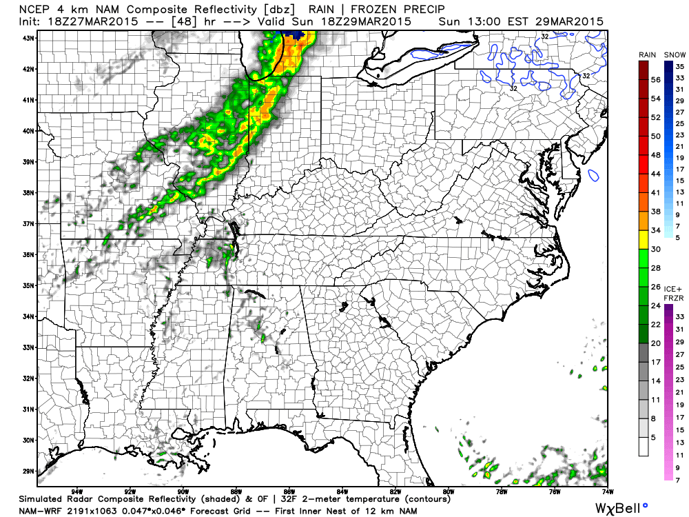
Sunday will bring some morning sun and afternoon clouds. A storm system will once again approach from the north. Thankfully by Sunday we will have temperatures back into the 50’s. Thus, snow can be ruled out on Sunday. Light rain showers will develop from the north and spread southward. Rainfall totals will be on the light side.
Future-cast radar for Sunday. You can see light showers on these images. Images are from weatherbell.com
Believe rumbles of thunder would stay to our south with this cold front. But, will monitor. Not worried about severe weather. No risk.
This is the 12 pm to 1 pm radar shot. Future-cast radar
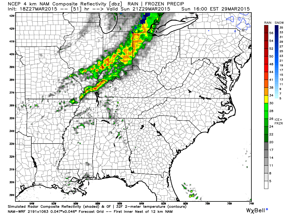
Future-cast radar for the 2 pm to 4 pm time frame. Rain showers will move southeast.
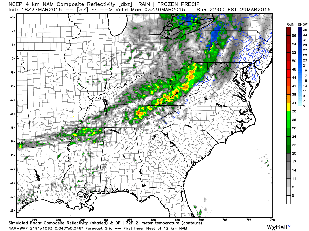
Future-cast radar for later on Sunday evening (below). Precipitation moves out rather quickly.
A more active weather pattern may develop towards the middle of the new workweek. Showers and thunderstorms will re-enter the picture towards Wednesday and Thursday. See the rainfall forecast map below. Some debate on how early the rain moves into the region. Right now it appears Wednesday and Thursday will have rain chances.
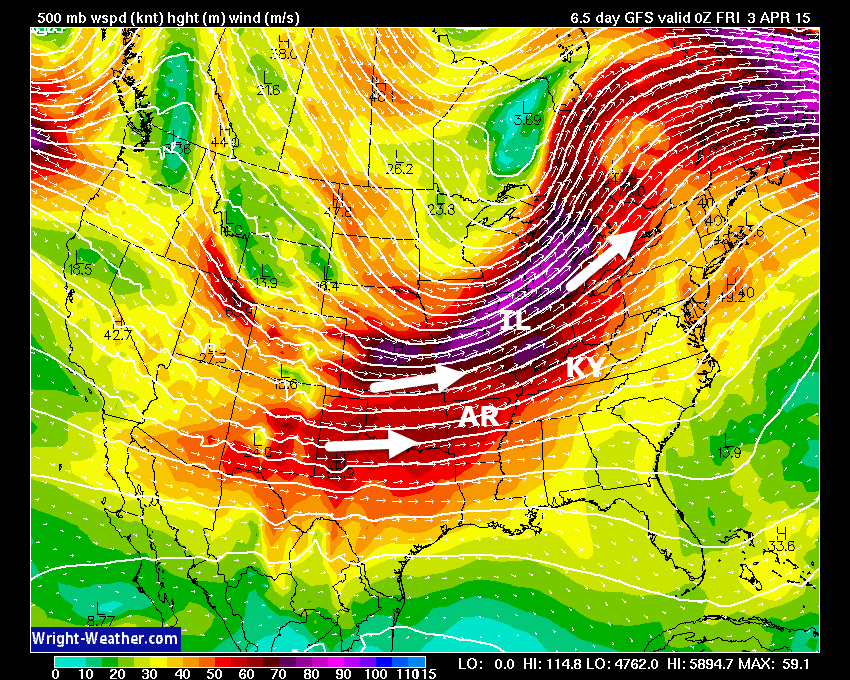
Let me show you what happens towards the middle of the week. Remember the map above…the northwest flow. Watch what happens towards the middle of the work-week
Do you see the difference in the winds aloft? They are no longer diving down from Canada. They are coming in more from the west/southwest. What happens when we have southwest flow? Moisture returns. Usually from the Pacific and the southwest. That will mean an increase in rain chances.
This is the Thursday morning jet stream map at 18,000 feet.
This is the Thursday night image. The different colors represent different wind speeds in the jet. Scale is at the bottom and is in knots. Notice some decent winds aloft (18,000′) on this map. Also notice where the winds are coming from. They are coming from the west/southwest.
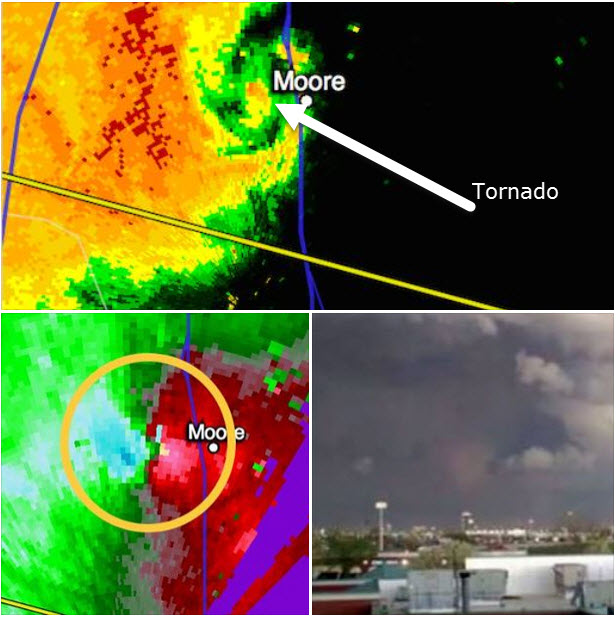
For those who were following the Moore, Oklahoma tornado. Mike Smith posted this image earlier today. You can see what a tornado looks like on radar.
The first image (top part) is the reflectivity. This normally shows rain (although it can even show debris during strong tornadoes)
The second image (bottom left) is the wind direction and speed. Those blue colors next to red is where the tornado is (circled area)
The image on the bottom right is the tornado itself.
Amazing what radar can do.
See the long range discussion for additional information on the weather past Thursday…
Radars
WEATHER RADAR PAGE – Click here —
I also set up a storm tracking page with additional links (use during active weather for quick reference)
Storm Tracking Tool Page
Don’t forget to support our sponsors!
Check out our sponsors! There are more on the right side bar of the page, as well. Be sure and let them know that you appreciate their sponsorship of the WeatherTalk daily weather bulletin.
How about a $5 meal deal? The DQ Grill and Chill (located across from Noble Park in Paducah, Kentucky) is the newest WeatherTalk Blog sponsor! A local business helping to sponsor the weather information that you have come to love so much.
Check out their Facebook page for specials, as well DQ Grill and Chill on Facebook


Premier Portable Buildings proudly serving our region. For more information click the above ad or here
They can also be found on this Facebook page
G&C Multi-Services out of Paducah, Kentucky. G & C Multi-Services is a service provider in Western Kentucky that provides industrial and commercial equipment fabrication, machine troubleshooting, repair and maintenance, and installation. They can custom fabricate steel, stainless, and aluminum products per customer specifications.
Visit their web-site here. Or click the ad below! Facebook page.


Wortham Dental Care located in Paducah, Kentucky. The gentle dentist. Mercury free dentistry. They also do safe Mercury removal. You can find Wortham Dental Care on Facebook, as well

Trover’s Equipment and Lawn Care – Family owned and operated! They are a dealer for Snapper, Simplicity, Snapper Pro, Bad Boy Mowers, and Intimidator Utility Vehicles. They are a Stihl and Dolmar power products dealer. They also are a dealer for Briggs & Stratton, Kohler gas & diesel engines, and Kawasaki engines. They service and repair just about any brand. You can find them on Facebook, as well
The School Bus Stop Forecast is brought to your by Shawnee Professional Services. For more information click here

Shawnee Professional Services & Civil Design Group have been providing Land Surveying, Engineering, Grant Administration and Acquisition services for the past 20 years. Currently Licensed in Illinois, Kentucky, Missouri, Indiana, and Tennessee; please contact Shawnee for any Land Surveying or Engineering needs. Shawnee’s company size allows them to devote individual attention to each client and to approach each project with the required thoroughness to successfully complete the project, large or small. Visit Shawnee’s website at shawneepsi.com for more information. Shawnee has offices in Paducah, KY, Vienna, IL and Benton, IL.
–

Here are the current river stage forecasts. You can click your state and then the dot for your location. It will bring up the full forecast and hydrograph.
Click Here For River Stage Forecasts…
Here are some current forecast hydrographs. These will be updated each day with new information.


Smithland Lock and Dam

Paducah, Kentucky Forecast Stage

Cairo, Illinois

The wild card tells you where the uncertainties are in the forecast
Wild card in this forecast – The wild card in this forecast will be low temperatures on Sunday morning. Some of us might dip back down into the 20’s. Thus, another freeze will be possible.

Can we expect severe thunderstorms over the next 24 to 48 hours? Remember that a severe thunderstorm is defined as a thunderstorm that produces 58 mph winds or higher, quarter size hail or larger, and/or a tornado.
Thunderstorm threat level is ZERO
Friday Severe Weather Outlook – No severe storms
Saturday Severe Weather Outlook – No severe storms
Sunday Severe Weather Outlook – A rumble of thunder for west TN is not out of the question Sunday evening/night.
Monday Severe Weather Outlook – No severe storms
Tuesday Severe Weather Outlook – No severe storms
Wednesday Severe Weather Outlook – MONITOR updates
Thursday Severe Weather Outlook – MONITOR updates
Saturday’s Thunderstorm Threat Level

Sunday night there could be a thunderstorm to our south (mainly). No severe storms are in the forecast. Thunder possible in the general thunderstorm area.

Will I need to take action?
Freeze conditions Friday night and Saturday morning. Another freeze possible Saturday night.
I can’t promise you we won’t see multiple freezes in April. I wish I could say we are done. But, I am not confident about that, yet.

How much precipitation should we expect over the next few days?
I will break this apart by days. We have the potential for a few precipitation events over the coming week.
The first one is tonight (Friday night’s) light snow event (mainly to our west).
Precipitation totals (melted) will be light
Images are from weatherbell.com
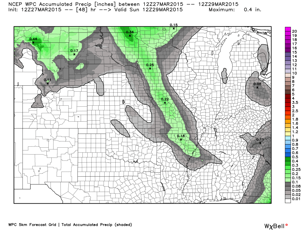
Our next precipitation event arrives on Sunday afternoon and night. Light event. Some rainfall totals of a trace to 0.10″ will be possible. Again, nothing significant. This is what that would look like.
Click image for larger view.
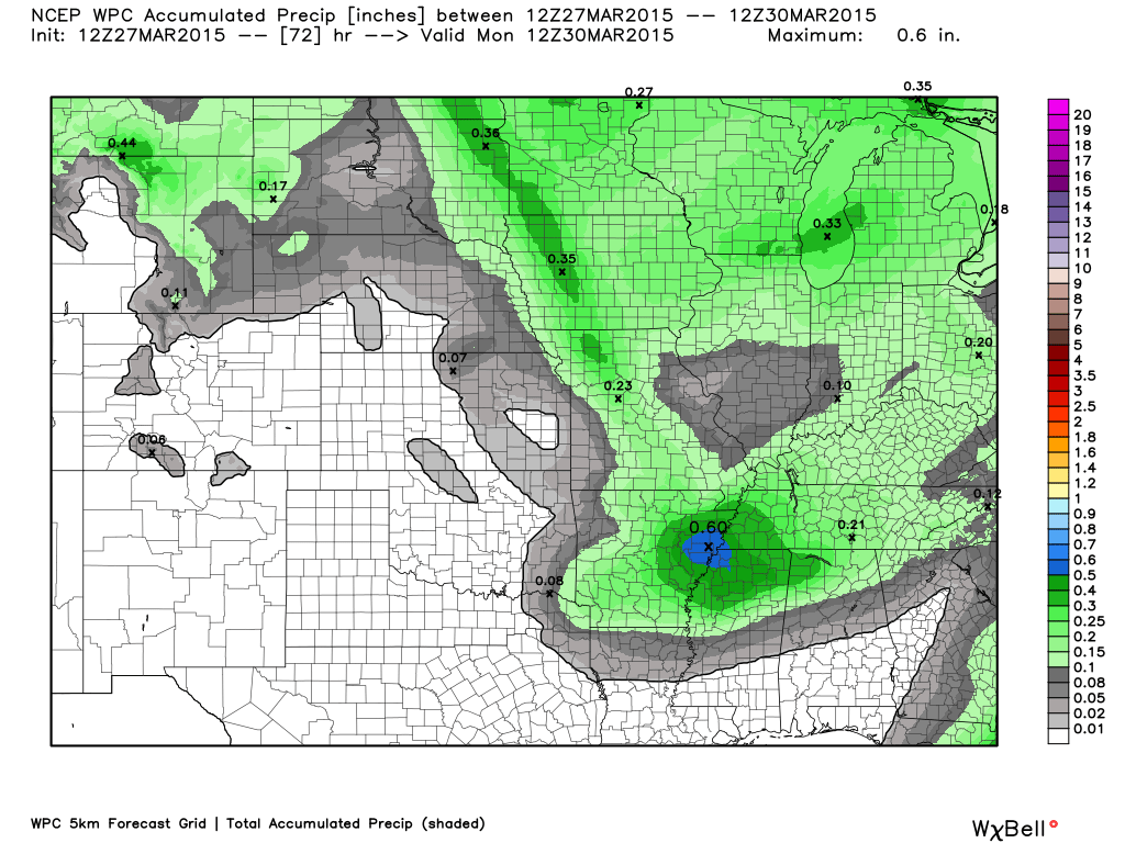
Then finally – this is through Friday. Obviously we have something going on here. Towards the middle and end of the week we may have moisture return to the region. There is some debate on how much precipitation. Keep that in mind.
These maps may change. For now, these are the precipitation totals through Friday.


Well, some snowflakes for Friday night and early Saturday morning for parts of southeast Missouri. Believe most of the activity will be over far western counties.
Otherwise, snow flurries are possible tonight over the entire area. Some sleet pellets, as well.
Spring will come in spurts this year. We are not finished with the cold weather.

This section of the blog is speculative forecast information. Because it is past the range of what meteorologists can forecast accurately, it should be considered speculation. Anything past day 5 is considered a long range forecast.
Well, who is on board for spring to stick around awhile? All of us? Me too. I wish I could tell you that is what is going to happen.
We are not finished with cold shots.
If you remember a few weeks ago I told you the end of March would be cold. I also said we might not be finished with teens and twenties. I went low confidence on the teens, but higher confidence on the 20’s.
Now, as we move forward…I am confident the coming cold shots into April will bring 30’s. I am also fairly confident that we may not be finished with the 20’s. That means we may have freeze warnings in April.
As always, long range forecasting is more speculation and an educated guess than it is anything else. We will see how it goes. I know many many of you are asking me about planting seeds.
I can’t promise you we won’t have freeze conditions in April.
We do have rain chances towards the middle and end of the new work week. I also looked ahead into April and there are several chances for showers and thunderstorms during the first two weeks. Locally heavy rain possible, as well.
Let’s look at the GFS model.
The GFS does okay in the long range (not so great in the short range)
I am not overly confident, however, about rain on Tuesday night. The GFS brings rain in faster than other data sets. I will monitor.
Rain is more likely as we move into Wednesday and Thursday/Friday. Some thunderstorms may also develop. Locally heavy rain can’t be ruled out.
Not sure about severe weather just yet. Monitor updates, as always. Weather is fluid in the spring.
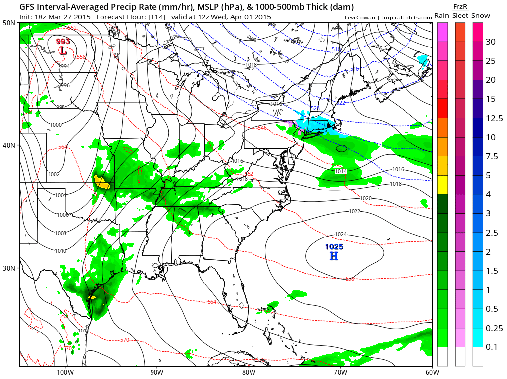
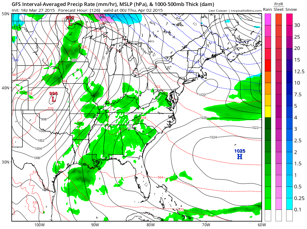
Future-cast precipitation maps from the GFS model. The green would be rain (hey, at least it is rain and not snow)
This first image is for Tuesday evening. Again, not sure rain moves in that fast, but I will monitor it.

This is the Wednesday morning map. Quite a bit of rain and maybe some storms in the region. Again, GFS is pretty fast with bringing this rain into the region. You can see a low to the west developing.
This image is Wednesday night. Low pressure over Kansas. That places us in the warm sector as a warm front moves north. Some rain and maybe thunder? We will see.
This is the Thursday morning map (below). Rain and thunderstorms in the region. Maybe some locally heavy rain.
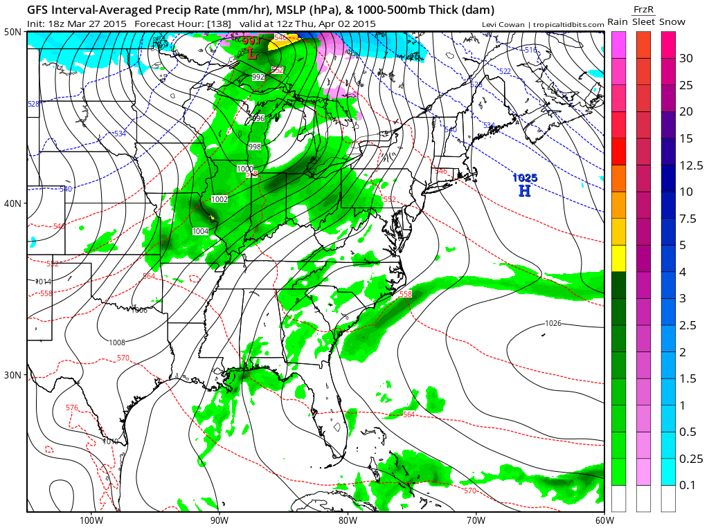
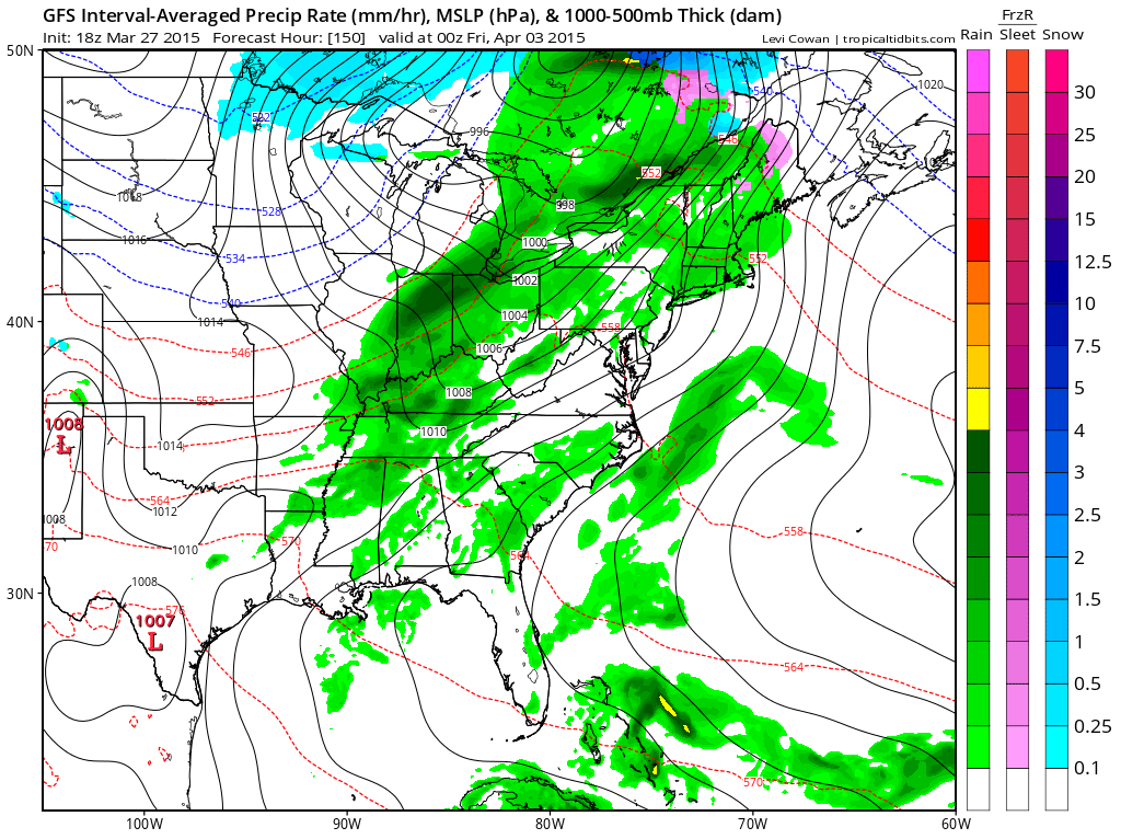
Below is the Thursday night map. Still rain and perhaps storms in our region.
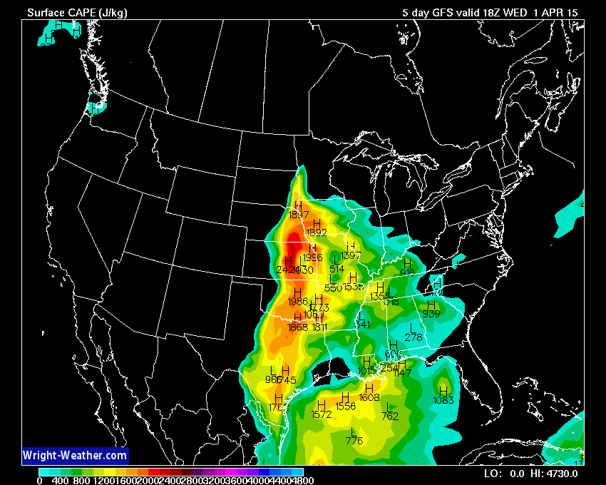
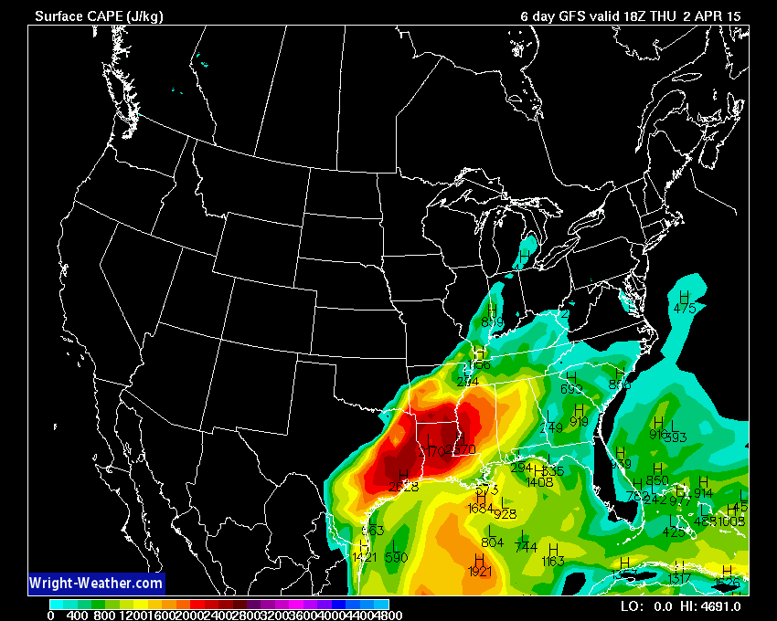
Let’s look at CAPE numbers for Wednesday and Thursday. Some CAPE is showing up. Remember CAPE is energy for storms. Basically (not a technical description). The higher the CAPE numbers then the more intense storms usually are.
More information on CAPE can be found here…for you enhanced weather enthusiasts – click here
This is the Wednesday afternoon CAPE map.
This is the Thursday afternoon CAPE numbers. Some energy around for storms that fire up.
 n
n

We have regional radars and local city radars – if a radar does not seem to be updating then try another one. Occasional browsers need their cache cleared. You may also try restarting your browser. That usually fixes the problem. Occasionally we do have a radar go down. That is why I have duplicates. Thus, if one fails then try another one.
If you have any problems then please send me an email beaudodson@usawx.com
WEATHER RADAR PAGE – Click here —
We also have a new national interactive radar – you can view that radar by clicking here.
Local interactive city radars include St Louis, Mt Vernon, Evansville, Poplar Bluff, Cape Girardeau, Marion, Paducah, Hopkinsville, Memphis, Nashville, Dyersburg, and all of eastern Kentucky – these are interactive radars. Local city radars – click here
NOTE: Occasionally you will see ground clutter on the radar (these are false echoes). Normally they show up close to the radar sites – including Paducah.

Regional Radar – Click on radar to take you our full radar page.


Regional Radar
![]()
Current WARNINGS (a warning means take action now). Click on your county to drill down to the latest warning information. Keep in mind that there can be a 2-3 minute delay in the updated warning information.
I strongly encourage you to use a NOAA Weather Radio or warning cell phone app for the most up to date warning information. Nothing is faster than a NOAA weather radio.


Color shaded counties are under some type of watch, warning, advisory, or special weather statement. Click your county to view the latest information.

Missouri Warnings

Illinois Warnings

Kentucky Warnings

Here is the official 6-10 day and 8-14 day temperature and precipitation outlook. Check the date stamp at the top of each image (so you understand the time frame).
The forecast maps below are issued by the Weather Prediction Center (NOAA).


The latest 8-14 day temperature and precipitation outlook. Note the dates are at the top of the image. These maps DO NOT tell you how high or low temperatures or precipitation will be. They simply give you the probability as to whether temperatures or precipitation will be above or below normal.


Who do you trust for your weather information and who holds them accountable?
I have studied weather in our region since the late 1970’s. I have 37 years of experience in observing our regions weather patterns. My degree is in Broadcast Meteorology from Mississippi State University and an Associate of Science (AS). I am currently working on my Bachelor’s Degree in Geoscience. Just need to finish two Spanish classes!
I am a member of the American Meteorological Society. I am a NOAA Weather-Ready Nation Ambassador. And, I am the Meteorologist for McCracken County Emergency Management.
I own and operate the Southern Illinois Weather Observatory.
There is a lot of noise on the internet. A lot of weather maps are posted without explanation. Over time you should learn who to trust for your weather information.
My forecast philosophy is simple and straight forward.
- Communicate in simple terms
- To be as accurate as possible within a reasonable time frame before an event
- Interact with you on Twitter, Facebook, and the blog
- Minimize the “hype” that you might see on television or through other weather sources
- Push you towards utilizing wall-to-wall LOCAL TV coverage during severe weather events
I am a recipient of the Mark Trail Award, WPSD Six Who Make A Difference Award, Kentucky Colonel, and the Caesar J. Fiamma” Award from the American Red Cross. In 2009 I was presented with the Kentucky Office of Highway Safety Award. I was recognized by the Kentucky House of Representatives for my service to the State of Kentucky leading up to several winter storms and severe weather outbreaks.
If you click on the image below you can read the Kentucky House of Representatives Resolution.

I am also President of the Shadow Angel Foundation which serves portions of western Kentucky and southern Illinois.
Many of my graphics are from www.weatherbell.com – a great resource for weather data, model data, and more


This blog was inspired by ABC 33/40’s Alabama Weather Blog – view their blog
Current tower cam view from the Weather Observatory- Click here for all cameras.

Southern Illinois Weather Observatory

The Weather Observatory

Southern Illinois Weather Observatory
WSIL TV 3 has a number of tower cameras. Click here for their tower camera page & Illinois Road Conditions

Marion, Illinois
WPSD TV 6 has a number of tower cameras. Click here for their tower camera page & Kentucky Road Conditions & Kentucky Highway and Interstate Cameras

Downtown Paducah, Kentucky
Benton, Kentucky Tower Camera – Click here for full view

Benton, Kentucky

I24 Paducah, Kentucky

I24 Mile Point 9 – Paducah, KY

I24 – Mile Point 3 Paducah, Kentucky

You can sign up for my AWARE email by clicking here I typically send out AWARE emails before severe weather, winter storms, or other active weather situations. I do not email watches or warnings. The emails are a basic “heads up” concerning incoming weather conditions.