WeatherTalk monthly operating costs can top $2000.00. Your $5 subscription helps pay for those costs. I work for you.
The $5 will allow you to register up to seven phones!
For $5 a month you can receive the following. You may choose to receive these via your WeatherTalk app or regular text messaging.
Severe weather app/text alerts from my keyboard to your app/cell phone. These are hand typed messages from me to you. During tornado outbreaks, you will receive numerous app/text messages telling you exactly where the tornado is located.
- Daily forecast app/texts from my computer to your app/cell phone.
- Social media links sent directly to your app/cell phone. When I update the blog, videos, or Facebook you will receive the link.
- AWARE emails. These emails keep you well ahead of the storm. They give you several days of lead time before significant weather events.
- Direct access to Beau via text and email. Your very own personal meteorologist. I work for you!
- Missouri and Ohio Valley centered video updates
- Long-range weather videos
- Week one, two, three and four temperature and precipitation outlooks.
Monthly outlooks. - Your subscription also will help support several local charities.
Would you like to subscribe? Subscribe at www.beaudodsonweather.com

I encourage subscribers to use the app vs regular text messaging. We have found text messaging to be delayed during severe weather. The app typically will receive the messages instantly. I recommend people have three to four methods of receiving their severe weather information.
Remember, my app and text alerts are hand typed and not computer generated. You are being given my personal attention during significant weather events.

WWW.WEATHERTALK.COM subscribers, here is my day to day schedule for your weather products.
These are bonus videos and maps for subscribers. I bring these to you from the BAMwx team. I pay them to help with videos.
The Ohio and Missouri Valley videos cover most of our area. They do not have a specific Tennessee Valley forecast but may add one in the future.
The long-range video is technical. Over time, you can learn a lot about meteorology from the long range video. Just keep in mind, it is a bit more technical.


.
![]()

.

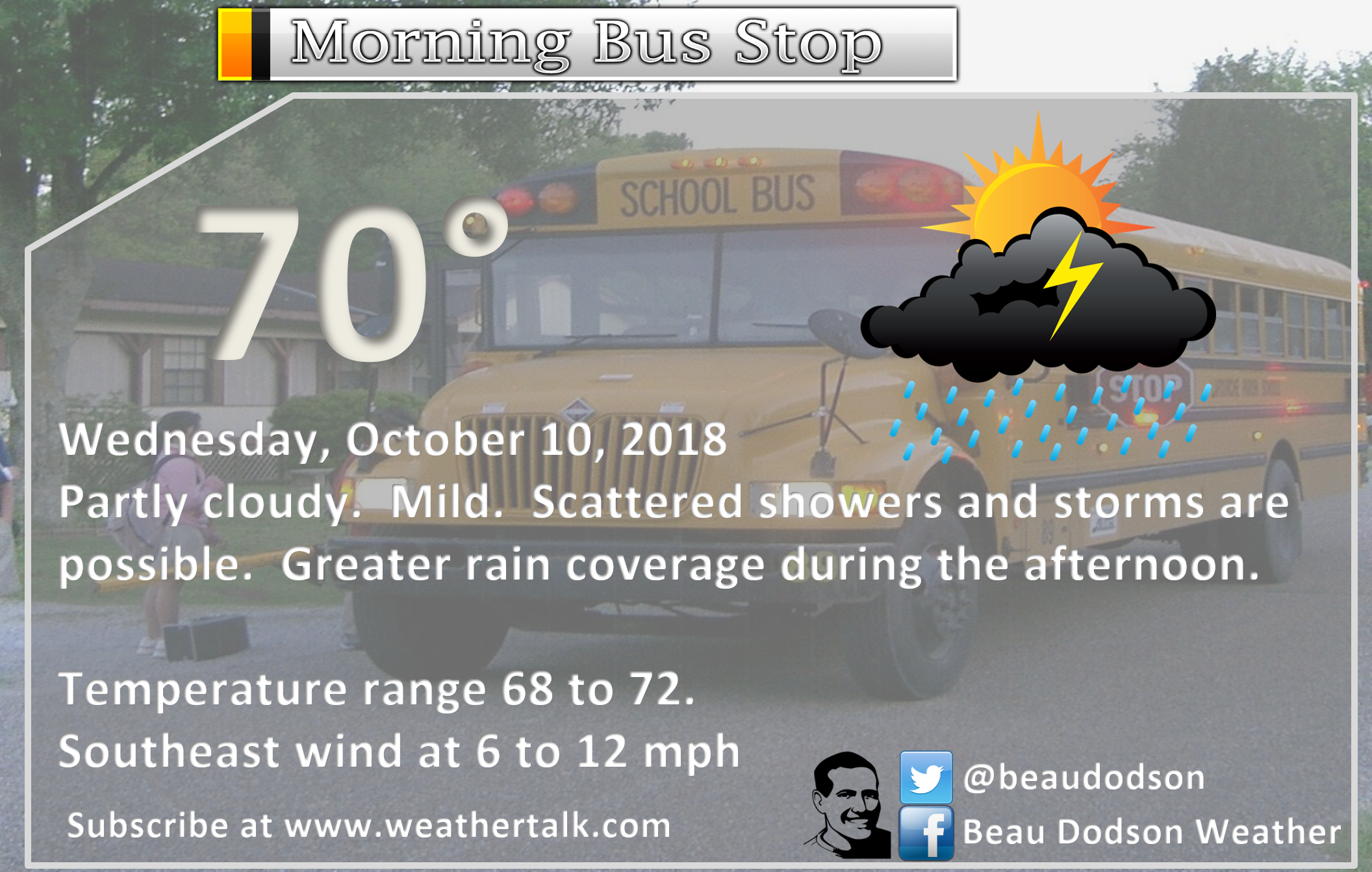
October 09, 2018
Tuesday forecast: Mostly sunny during the morning. Increasing clouds through the day. An isolated shower ot storm possible. Most of the area will remain dry.
Temperatures: MO ~ 82 to 86 IL ~ 84 to 86 KY ~ 84 to 88 TN ~ 84 to 88
What is the chance of precipitation? MO ~ 20% to 30% IL ~ 20% KY ~ 20% TN ~ 20%
Coverage of precipitation: Isolated
Wind: South and southeast at 8 to 16 mph with higher gusts likely
What impacts are anticipated from the weather? None to isolated wet roads and lightning.
My confidence in the forecast verifying: High
Is severe weather expected? No
The NWS defines severe weather as 58 mph wind or great, 1″ hail or larger, and/or tornadoes
Should I cancel my outdoor plans? No, but I would check radars
UV Index: 6 to 8 High (if clouds are thicker, then this number will be lowered)
Sunrise: 6:58 AM
Tuesday Night Forecast Details:
Forecast: Mostly cloudy with showers and thunderstorms developing, especially late tonight.
Temperatures: MO ~ 64 to 68 IL ~ 64 to 68 KY ~ 64 to 68 TN ~ 64 to 68
What is the chance of precipitation? MO ~ 30% before 1 AM and 60% chance after 1 AM IL ~ 20% chance before 3 AM and a 40% chance after 3 AM KY ~ 40% to 50% mainly after 4 AM TN ~ 40% to 50% mainly after 4 AM
Coverage of precipitation: Isolated early, but becoming more numerous late tonight
Wind: Southeast winds at 6 to 12 mph with higher gusts
What impacts are anticipated from the weather? Wet roadways and lightning.
My confidence in the forecast verifying: High
Is severe weather expected? No
The NWS defines severe weather as 58 mph wind or great, 1″ hail or larger, and/or tornadoes
Should I cancel my outdoor plans? No, but check radars
Sunset: 6:27 PM
Moonrise: 7:18 AM New Moon
Moonset: 7:12 PM
October 10, 2018
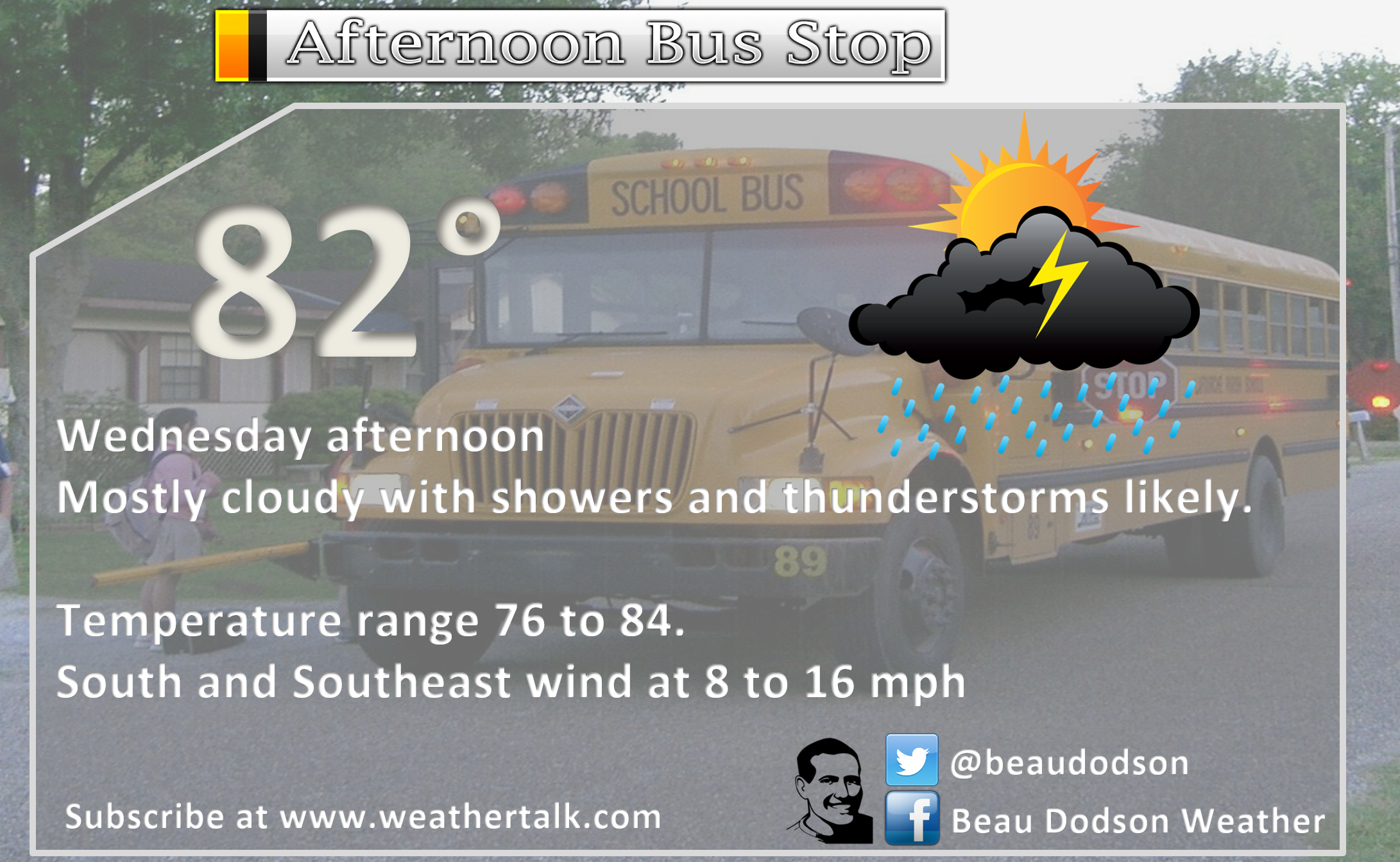
Wednesday forecast: Cloudy with showers and thunderstorms likely.
Temperatures: MO ~ 74 to 82 IL ~ 76 to 82 KY ~ 76 to 82 TN ~ 76 to 82
What is the chance of precipitation? MO ~ 70% IL ~ 70% KY ~ 70% TN ~ 70%
Coverage of precipitation: Numerous
Wind: South and southwest at 8 to 16 mph
What impacts are anticipated from the weather? Wet roadways. Lightning.
My confidence in the forecast verifying: Medium
Is severe weather expected? The risk of severe weather is low.
The NWS defines severe weather as 58 mph wind or great, 1″ hail or larger, and/or tornadoes
Should I cancel my outdoor plans? Have a plan B
UV Index: 1 to 2 low
Sunrise: 6:59 AM
Wednesday Night Forecast Details:
Forecast: Mostly cloudy with showers and thunderstorms ending from west to east.
Temperatures: MO ~ 46 to 54 IL ~ 50 to 55 KY ~ 50 to 55 TN ~ 52 to 56
What is the chance of precipitation? MO ~ 30% IL ~ 60% KY ~ 60% TN ~ 60%
Coverage of precipitation: Numerous early and becoming scattered and ending as the night wears on.
Wind: Southwest becoming west/northwest at 8 to 16 mph
What impacts are anticipated from the weather? Wet roadways and lightning early in the night
My confidence in the forecast verifying: High
Is severe weather expected? Unlikely
The NWS defines severe weather as 58 mph wind or great, 1″ hail or larger, and/or tornadoes
Should I cancel my outdoor plans? Have a plan B
Sunset: 6:25 PM
Moonrise: 8:25 AM New Moon
Moonset: 7:46 PM
October 11, 2018
Thursday forecast: Partly cloudy and cooler. Temperatures may fall during the day as a cold front moves further and further eastward.
Temperatures: MO ~ 62 to 66 IL ~ 62 to 66 KY ~ 62 to 66 TN ~ 62 to 66
What is the chance of precipitation? MO ~ 0% IL ~ 0% KY ~ 10% TN ~ 10%
Coverage of precipitation: Most likely none. Rain should have ended.
Wind: North and northwest at 6 to 12 mph with higher gusts possible
What impacts are anticipated from the weather? None
My confidence in the forecast verifying: High
Is severe weather expected? No
The NWS defines severe weather as 58 mph wind or great, 1″ hail or larger, and/or tornadoes
Should I cancel my outdoor plans? No
UV Index: 5 Medium
Sunrise: 7:00 AM
Thursday Night Forecast Details:
Forecast: Mostly clear. Patchy fog possible. Chilly temperatures.
Temperatures: MO ~ 42 to 44 IL ~ 42 to 44 KY ~ 44 to 46 TN ~ 44 to 46
What is the chance of precipitation? MO ~ 0% IL ~ 0% KY ~ 0% TN ~ 0%
Coverage of precipitation: None
Wind: North at 6 to 12 mph
What impacts are anticipated from the weather? Lower visibility if fog forms.
My confidence in the forecast verifying: High
Is severe weather expected? No
The NWS defines severe weather as 58 mph wind or great, 1″ hail or larger, and/or tornadoes
Should I cancel my outdoor plans? No
Sunset: 6:24 PM
Moonrise: 9:29 AM Waxing Crescent
Moonset: 8:23 PM
October 12, 2018
Friday forecast: Mostly to partly sunny. Cool.
Temperatures: MO ~ 62 to 66 IL ~ 62 to 66 KY ~ 62 to 66 TN ~ 62 to 66
What is the chance of precipitation? MO ~ 10% IL ~ 10% KY ~ 0% TN ~ 0%
Coverage of precipitation: Most likely none
Wind: North and northwest at 6 to 12 mph
What impacts are anticipated from the weather? Most likely none
My confidence in the forecast verifying: Medium
Is severe weather expected? No
The NWS defines severe weather as 58 mph wind or great, 1″ hail or larger, and/or tornadoes
Should I cancel my outdoor plans? No
UV Index: 5 moderate
Sunrise: 7:00 AM
Friday Night Forecast Details:
Forecast: Mostly clear. A few evening clouds. Chilly temperatures.
Temperatures: MO ~ 42 to 46 IL ~ 42 to 46 KY ~ 44 to 46 TN ~ 44 to 48
What is the chance of precipitation? MO ~ 0% IL ~ 0% KY ~ 0% TN ~ 0%
Coverage of precipitation: Most likely none
Wind: North and northeast at 5 to 10 mph
What impacts are anticipated from the weather? Most likely none
My confidence in the forecast verifying: Medium
Is severe weather expected? No
The NWS defines severe weather as 58 mph wind or great, 1″ hail or larger, and/or tornadoes
Should I cancel my outdoor plans? No
Sunset: 6:12 PM
Moonrise: 10:31 AM Waxing Crescent
Moonset: 9:02 PM
October 13, 2018
Saturday forecast: Partly sunny. I will be monitoring rain chances. There is the chance a weak system moves into the region.
Temperatures: MO ~ 60 to 65 IL ~ 60 to 65 KY ~ 60 to 65 TN ~ 60 to 65
What is the chance of precipitation? MO ~ 10% IL ~ 10% KY ~ 10% TN ~ 10%
Coverage of precipitation: Most likely none, but monitor updates
Wind: East at 5 to 10 mph winds becoming southeast at 7 to 14 mph
What impacts are anticipated from the weather? Most likely none
My confidence in the forecast verifying: Medium
Is severe weather expected? No
The NWS defines severe weather as 58 mph wind or great, 1″ hail or larger, and/or tornadoes
Should I cancel my outdoor plans? No, but monitor updates
UV Index: 5 moderate
Sunrise: 7:01 AM
Saturday Night Forecast Details:
Forecast: Increasing cloud cover. It appears rain showers will develop mainly late Saturday night. Confidence on this is now medium. Cool temperatures.
Temperatures: MO ~ 50 to 55 IL ~ 50 to 55 KY ~ 50 to 55 TN ~ 50 to 55
What is the chance of precipitation? MO ~ 40% IL ~ 40% KY ~ 40% TN ~ 40%
Coverage of precipitation: Increasing rain coverage through the night.
Wind: East and southeast at 5 to 10 mph
What impacts are anticipated from the weather? Wet roadways.
My confidence in the forecast verifying: Medium
Is severe weather expected? No
The NWS defines severe weather as 58 mph wind or great, 1″ hail or larger, and/or tornadoes
Should I cancel my outdoor plans? I would monitor updated forecasts.
Sunset: 6:21 PM
Moonrise: 11:30 AM Waxing Crescent
Moonset: 9:44 PM
October 14, 2018
Sunday forecast: Mostly cloudy. A chance of rain.
Temperatures: MO ~ 55 to 60 IL ~ 55 to 60 KY ~ 55 to 60 TN ~ 55 to 60
What is the chance of precipitation? MO ~ 60% IL ~ 60% KY ~ 60% TN ~ 60%
Coverage of precipitation: Widespread
Wind: South and southwest at 8 to 16 mph
What impacts are anticipated from the weather? Wet roadways
My confidence in the forecast verifying: LOW / adjustments possible
Is severe weather expected? No
The NWS defines severe weather as 58 mph wind or great, 1″ hail or larger, and/or tornadoes
Should I cancel my outdoor plans? Monitor updates
UV Index: 2 to 3 Low
Sunrise: 7:02 AM
Sunday Night Forecast Details:
Forecast: Mostly cloudy. Rain showers early. Cool temperatures.
Temperatures: MO ~ 46 to 54 IL ~ 46 to 54 KY ~ 46 to 54 TN ~ 46 to 54
What is the chance of precipitation? MO ~ 60% IL ~ 60% KY ~ 60% TN ~ 60%
Coverage of precipitation: Scattered
Wind: North at 7 to 14 mph and gusty
What impacts are anticipated from the weather? Wet roadways
My confidence in the forecast verifying: LOW / adjustments possible
Is severe weather expected? No
The NWS defines severe weather as 58 mph wind or great, 1″ hail or larger, and/or tornadoes
Should I cancel my outdoor plans? Monitor updates
Sunset: 6:19 PM
Moonrise: 12:26 PM Waxing Crescent
Moonset: 10:29 PM
October 15, 2018
Monday forecast: Partly sunny. Cool. A few showers possible.
Temperatures: MO ~ 55 to 60 IL ~ 55 to 60 KY ~ 55 to 60 TN ~ 55 to 60
What is the chance of precipitation? MO ~ 20% IL ~ 30% KY ~ 30% TN ~ 30%
Coverage of precipitation: Widely scattered
Wind: North and northwest at 7 to 14 mph
What impacts are anticipated from the weather? A few wet roadways
My confidence in the forecast verifying: Medium
Is severe weather expected? No
The NWS defines severe weather as 58 mph wind or great, 1″ hail or larger, and/or tornadoes
Should I cancel my outdoor plans? A few showers possible. Monitor radars.
UV Index: 2 to 3 Low
Sunrise: 7:03 AM
Monday Night Forecast Details:
Forecast: Clearing and chilly. Patchy fog possible. Frost possible. Still a bit early to know if frost will occur. Monitor updates.
Temperatures: MO ~ 38 to 44 IL ~ 38 to 44 KY ~ 40 to 45 TN ~ 40 to 45
What is the chance of precipitation? MO ~ 0% IL ~ 0% KY ~ 0% TN ~ 0%
Coverage of precipitation: None
Wind: Northwest at 5 to 10 mph
What impacts are anticipated from the weather? Lower visibility in fog. Monitor the risk of frost.
My confidence in the forecast verifying: Medium
Is severe weather expected? No
The NWS defines severe weather as 58 mph wind or great, 1″ hail or larger, and/or tornadoes
Should I cancel my outdoor plans? No
Sunset: 6:18 PM
Moonrise: 1:17 PM Waxing Crescent
Moonset: 11:18 PM
Monitoring the 20th through 23rd for a cold front
Monitoring Halloween (around) for another cold front
Learn more about the UV index readings. Click here.

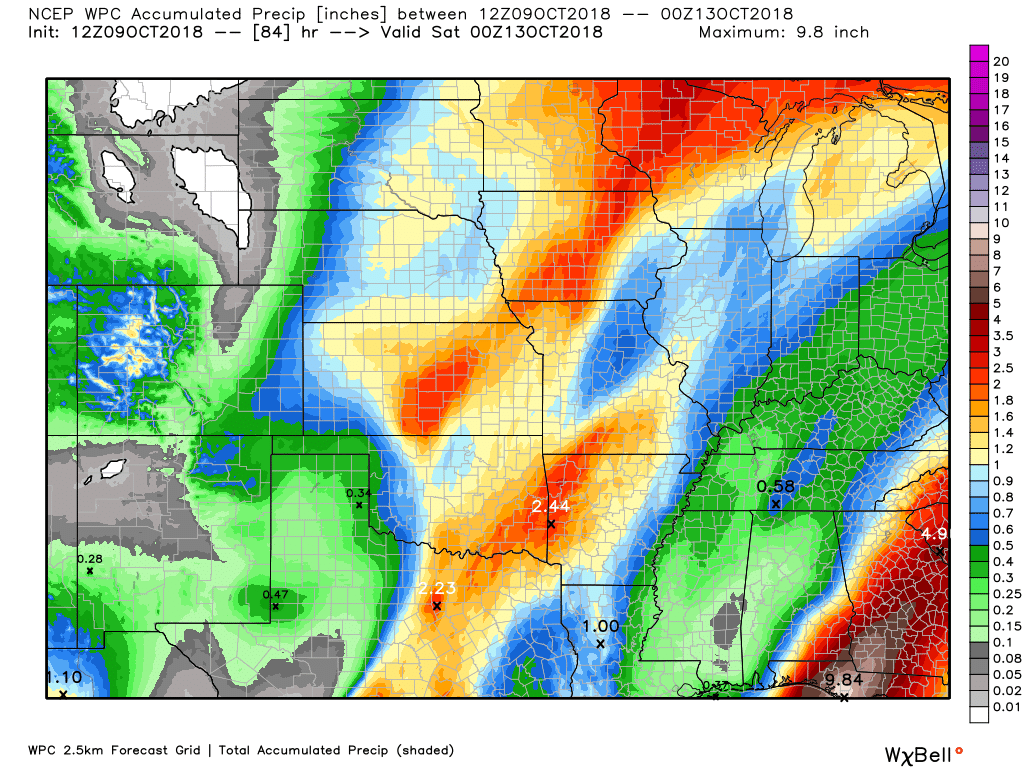
Here is the latest WPC/NOAA rainfall outlook.
This covers the rainfall now through Friday night.
Most of this will form tonight into Wednesday evening. For the most part, this appears to be a .25″ to .50″ rain event. There will be pockets of 0.50″ to 0.75″. Thunderstorms can always drop a bit more rain than surrounding areas.
Click to enlarge.
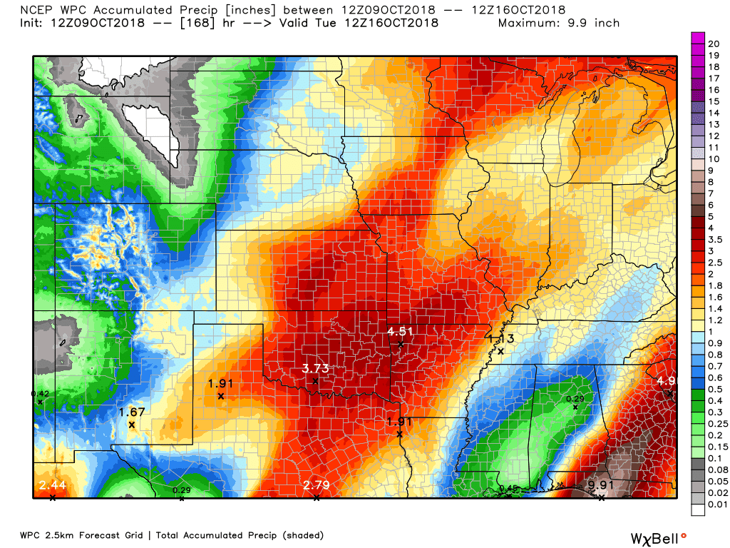
A second rain event is forecast Saturday night and especially on Sunday and Sunday night. A few spotty showers may remain into Monday.
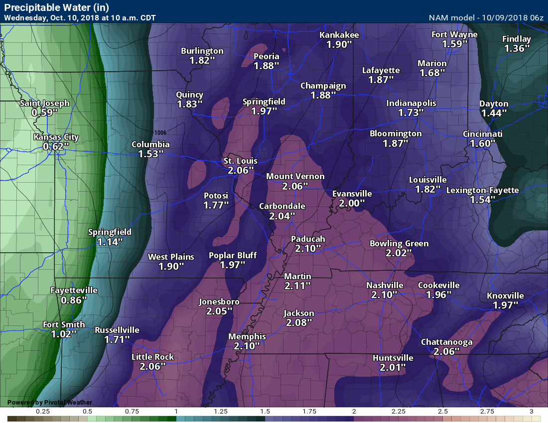
When you add that event with the first event you could receive these totals.
Some of the guidance paints heavy rain in the region Sunday. I will be monitoring trends in the guidance.
Again, click to enlarge the image.
Did you know that you can find me on Twitter?

Need a forecast for an outdoor event?


We offer interactive local city live radars and regional radars.
If a radar does not update then try another one. If a radar does not appear to be refreshing then hit Ctrl F5 on your keyboard.
You may also try restarting your browser. The local city view radars also have clickable warnings.
During the winter months, you can track snow and ice by clicking the winterize button on the local city view interactive radars.

Questions? Broken links? Other questions?
You may email me at beaudodson@usawx.com

The National Weather Service defines a severe thunderstorm as one that produces quarter size hail or larger, 58 mph winds or greater, and/or a tornado.
Today through Wednesday evening: An approaching cold front will produce showers and thunderstorms. Some of the thunderstorms will produce heavy downpours and 30 mph wind gusts.
Thursday through Monday: Severe weather is not anticipated. I am monitoring rain chances Saturday night into Sunday night. I can’t rule out thunderstorms, but that will be dependent on the track of the area of low pressure.
Interactive live weather radar page. Choose the city nearest your location. If one of the cities does not work then try a nearby one. Click here.
National map of weather watches and warnings. Click here.
Storm Prediction Center. Click here.
Weather Prediction Center. Click here.

Live lightning data: Click here.

Interactive GOES R satellite. Track clouds. Click here.

Here are the latest local river stage forecast numbers Click Here.
Here are the latest lake stage forecast numbers for Kentucky Lake and Lake Barkley Click Here.

- Here comes the rain
- Cooler temperatures are on the way
- Tracking Hurricane Michael
- I have added rain to the weekend forecast
Another warm day on tap for the region. Perhaps not as warm as recent days. Highs will mostly be in the middle 80’s. A couple of showers or thunderstorms are possible today. Many areas will simply remain dry into the evening hours.
A strong cold front will usher in cooler air over the next 48 hours. A much anticipated cold front, I might add. Many have been looking for autumn temperatures. You are about to get your wish.
The front will push through the entire region by Thursday morning.
Showers and thunderstorms will increase in coverage as we move through tonight. The atmosphere won’t be all that unstable, so the risk of severe weather appears to not be a concern. There can always be lightning, keep that in mind. A few heavy downpours are possible, as well.
PWAT values will be high.
PWAT is a measure of moisture in the entire atmosphere. What does that mean? It means the showers and thunderstorms will have plenty of moisture to pull from.
These are not rain totals.
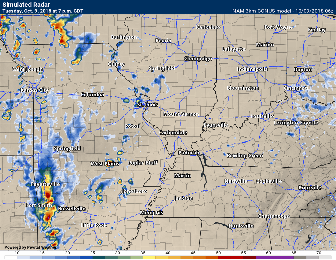
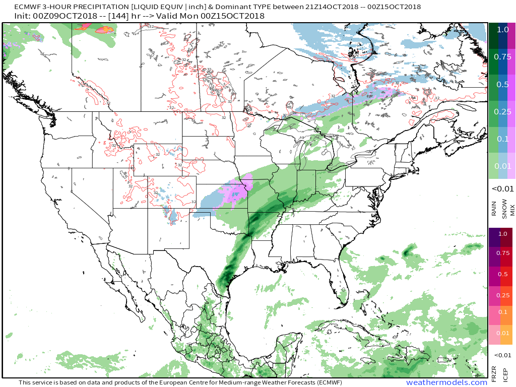
Widespread showers and thunderstorms will spread across the region from west to east through the overnight hours into Wednesday morning. The front will be progressive and that will mean frontal passage by Wednesday night/Thursday morning.
Click to enlarge
Keep in mind, this is a models interpretation of what radar may look like into Thursday. The coverage could be larger than this. That is one question on the table about this event.
You can see a line of showers and thunderstorms form along the front Wednesday morning and then again Wednesday afternoon.
The cool air will lag behind the front a bit. We may even see falling temperatures Thursday. Highs by Thursday into Monday will remain mostly in the 60’s! The coolest streak of the autumn season, thus far.
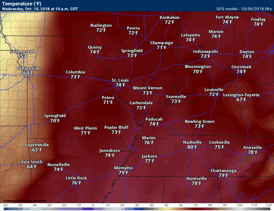
Here are the GFS temperatures. This animation takes us from Wednesday afternoon into Thursday evening.
Click to enlarge the animation.
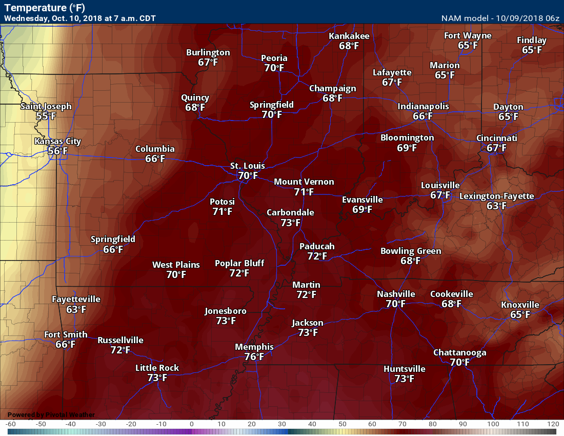
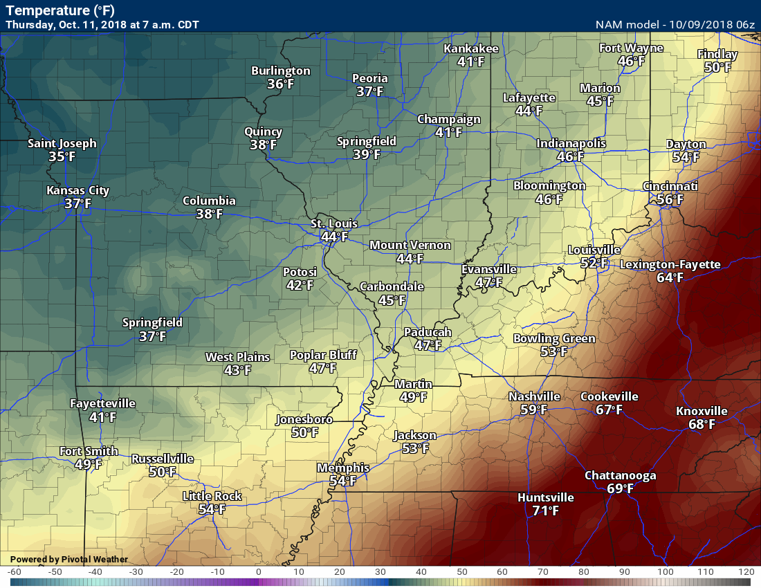
Check out the 24-hour temperature drop behind the front. This would be 7 AM Wednesday compared with 7 AM Thursday.
That is quite the temperature drop. Strong cold front.
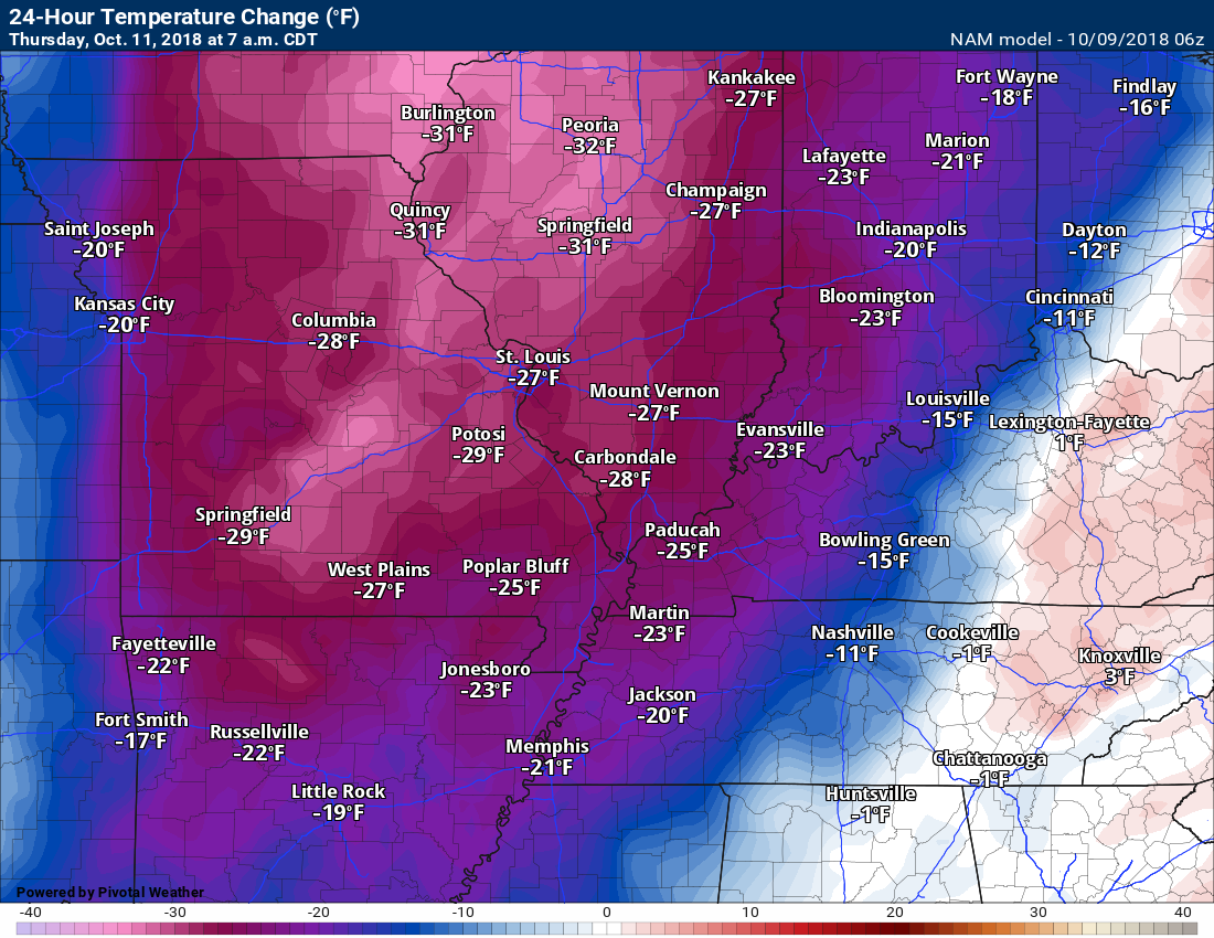
7 AM Wednesday temperatures
7 AM Thursday temperatures
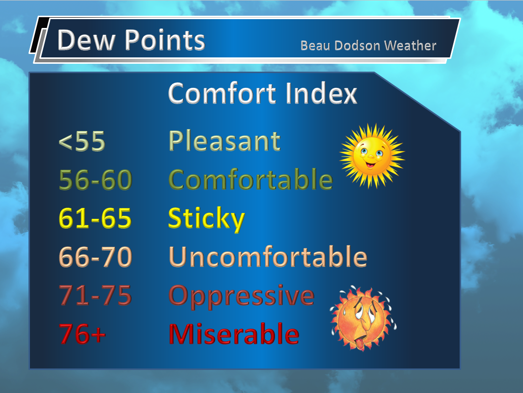
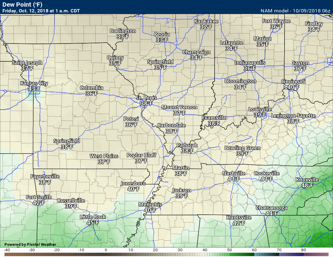
Dew points will fall behind the front, as well. Dewpoint controls how humid it feels.
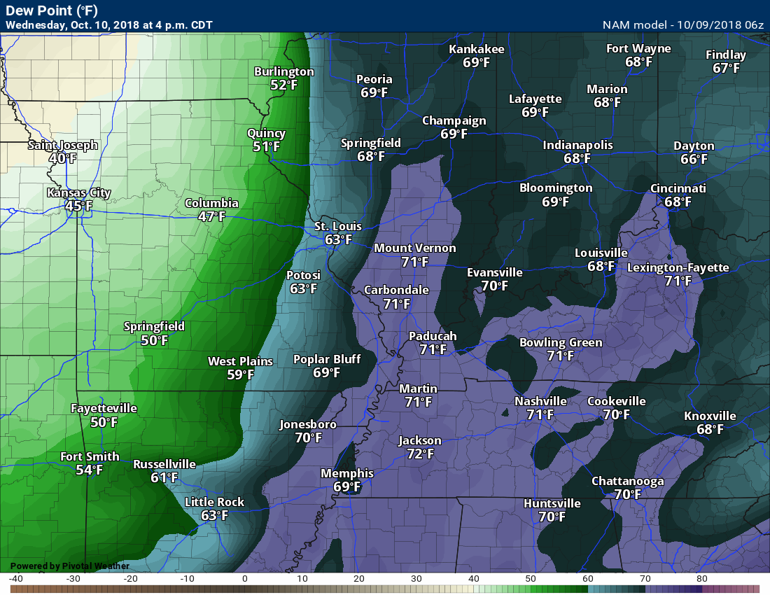
Here are the dewpoints ahead of the cold front.
Here are the dewpoints behind the cold front. What a difference! It will certainly feel like autumn.
Another cold front will push into the region late Saturday night and especially on Sunday. This front will deliver more showers to the region.
There are some questions about rain totals Sunday. I will be monitoring for training precipitation. Perhaps not thunderstorms, but moderate rain showers. If the showers run parallel to the front, then some areas could receive over an inch of rain. Confidence on this remains low. Either way, additional rain appears likely with the second cold front.
The second cold front will reinforce the cool temperatures and keep us below the seasonal norms of 74/50 (high/low) degrees.
Frost?
I will be monitoring for the potential of frost Monday night. Still a bit early to know if temperatures will fall into the 30’s. It is possible.
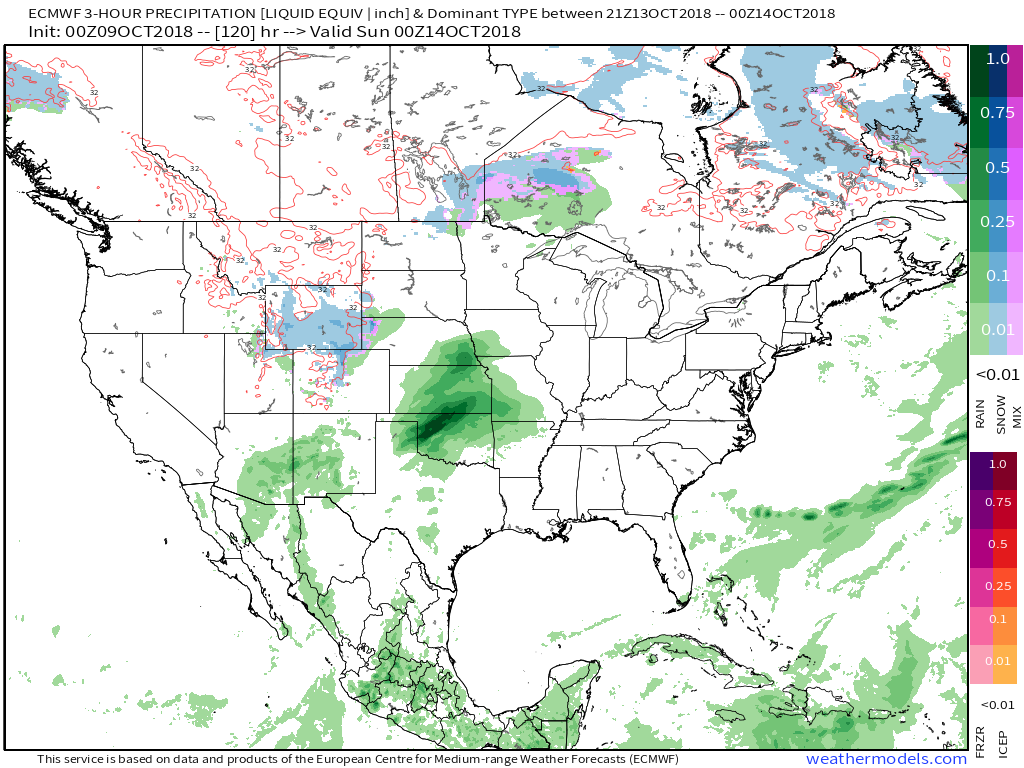
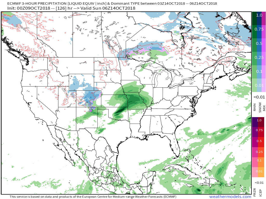
You can see our second rain event on the EC model guidance.
Green would be the rain.
7 PM Saturday. You can see the rain to our west/southwest.
1 AM Sunday. The rain spreads into our region. I will be monitoring the timing of the rain.
1 PM Sunday
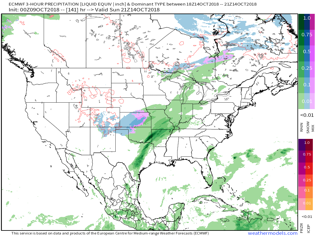
7 PM Sunday
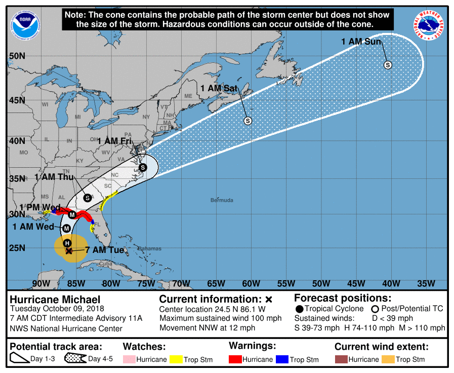
Michael
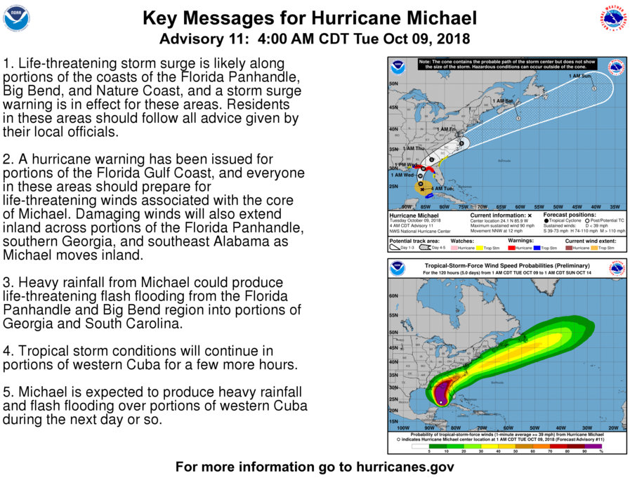
Hurricane Michael continues to move northward through the Gulf of Mexico. The latest forecast and graphics can be viewed on this website National Hurricane Center . I know some of you are on vacation along the Gulf of Mexico.
Monitor updates from local officials/television meteorologists concerning this storm. The local meteorologists along the Gulf of Mexico will certainly be talking about this. The greatest risk will likely extend from the coastline of Alabama eastward into the Florida Panhandle and the east coast of Florida.
National Hurricane Center Link to their homepage – click here
AGAIN SEE THE LATEST AT THE LINK ABOVE
THESE GRAPHICS ARE TIME-SENSITIVE
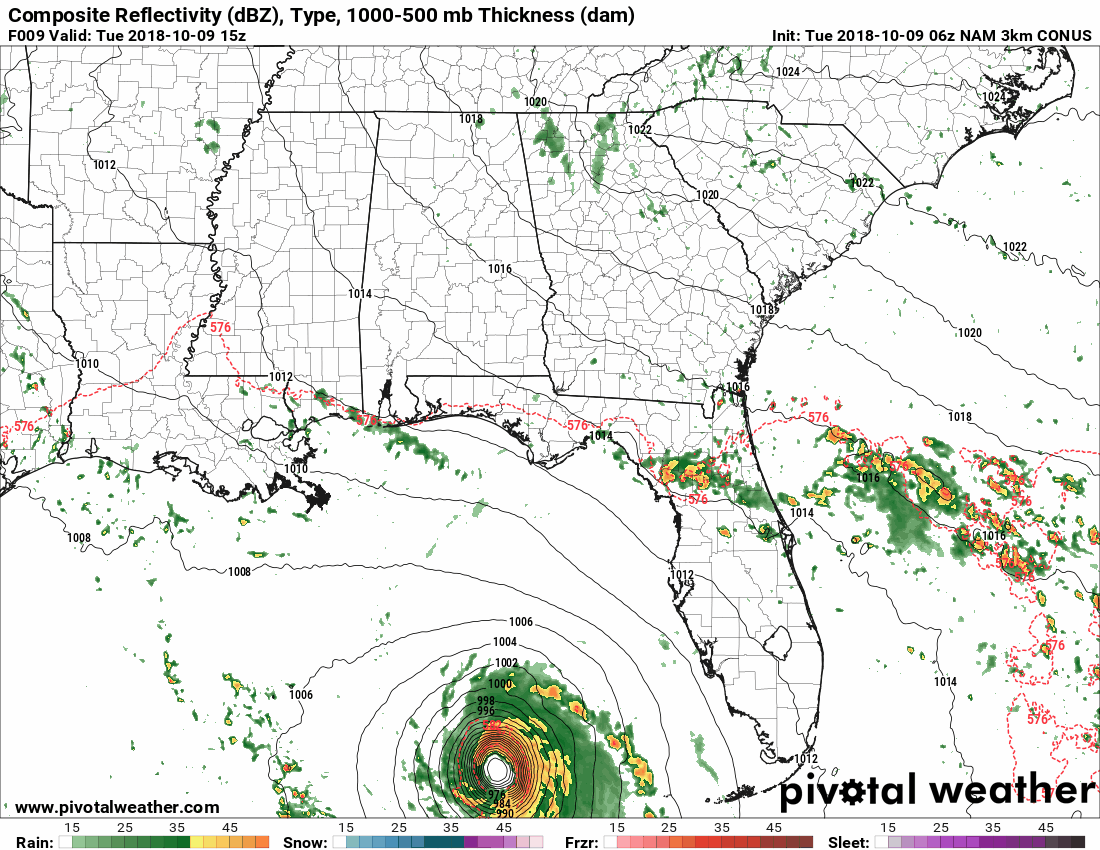
Here is the NAM model guidance future-cast radar.
KEEP IN MIND, ADJUSTMENTS IN THE PATH OF MICHAEL ARE POSSIBLE. This is one model’s opinion.
Conditions to the west of the eye may spread further west than this model indicates.
Long range outlooks show another strong cold front around October 20th through October 22nd.
We will watch that one for thunderstorms and colder temperatures. Not sure about frost, just yet. I am monitoring trends in the guidance.
Long range outlooks show another strong cold front around October 20th through October 22nd. We will watch that one for thunderstorms and colder temperatures. Not sure about frost, just yet. I am monitoring that portion of the forecast.
![]()
Bonus VIDEO UPDATES
These are bonus videos and maps for subscribers. I bring these to you from the BAMwx team. I pay them to help with videos.
The Ohio and Missouri Valley videos cover most of our area. They do not have a specific Tennessee Valley forecast but may add one in the future.
The long-range video is technical. Over time, you can learn a lot about meteorology from the long range video. Just keep in mind, it is a bit more technical.
Here is the current track forecast of that hurricane. The end result here would be rain. No concerns about wind.
![]()
Here is the preliminary fall outlook from the long-range meteorology team.
Click to enlarge this graphic.
.
![]()
The September forecast has been updated.
![]()

I bring these to you from the BAMwx team. They are excellent long-range forecasters.
Remember, long-range outlooks are a bit of skill, understanding weather patterns, and luck combined. It is not an exact science.

This product is for subscribers.
Subscribe at www.weathertalk.com
Subscriber graphics can be viewed on this page CLICK HERE

This product is for subscribers.

Subscriber graphics can be viewed on this page CLICK HERE
![]()
.
Fall Outlook!
Preliminary October precipitation outlook
Here is the preliminary November temperature and precipitation outlook
Preliminary November temperature outlook
Preliminary November precipitation outlook
.These products are for subscribers.
![]()

A new weather podcast is now available! Weather Geeks (which you might remember is on The Weather Channel each Sunday)
To learn more visit their website. Click here.
![]()

WeatherBrains Episode 663
Joining us as our Guest WeatherBrain this week is a hydrologist in the Research Applications Lab at NCAR. He has a background in hydrology, geology and computer science. In graduate school, he found a happy marriage of these in hydrological modeling, remote sensing, and more recently atmospheric modeling. Ethan Gutmann, welcome to WeatherBrains!
Other discussions in this weekly podcast include topics like:
- Should we re-do hurricane classification?
- Ethan’s hobby of mountain climbing
- U. S. Weather Roundup
- Remnants of Hurricane Rosa entering SW United States
- Astronomy Outlook with Tony Rice
- and more!
.
.
Link to their website https://weatherbrains.com/
Previous episodes can be viewed by clicking here.

We offer interactive local city live radars and regional radars. If a radar does not update then try another one. If a radar does not appear to be refreshing then hit Ctrl F5. You may also try restarting your browser.
The local city view radars also have clickable warnings.
During the winter months, you can track snow and ice by clicking the winterize button on the local city view interactive radars.
You may email me at beaudodson@usawx.com
Find me on Facebook!

Find me on Twitter!

Did you know that a portion of your monthly subscription helps support local charity projects?
You can learn more about those projects by visiting the Shadow Angel Foundation website and the Beau Dodson News website.

I encourage subscribers to use the app vs regular text messaging. We have found text messaging to be delayed during severe weather. The app typically will receive the messages instantly. I recommend people have three to four methods of receiving their severe weather information.
Remember, my app and text alerts are hand typed and not computer generated. You are being given personal attention during significant weather events.
