Wednesday into Friday
Somewhat cooler air will arrive on Wednesday and Thursday. Expect high temperatures in the 70’s. This will still be above the seasonal norms of 73 to 75.
Where is fall? Good question.
We will warm back into the 80’s by Friday.
I am monitoring another cold front for the weekend.
Frost forecast
Frost is not in the forecast through Saturday.


.
A Weather Talk subscription ($3 a month) is required to view the videos.
Videos are posted on the www.weathertalk.com website. Once there, click the Beau Video-Cast tab. Long Range Video Update
If you believe you missed a video then you may check the LIVE FEED link on the Weather Talk website. You will find an archive of videos on that page.
You can also receive the videos via your Weather Talk app/text messages. Have text option FOUR activated. The Weather Extra text option. Sign up for the app/text messages, videos, and more at www.beaudodsonweather.com
.
This forecast covers the counties in red. The counties in orange are covered by the forecast discussion further down in the blog.


.
October 8, 2017
Sunday Night Forecast Details:
Forecast: Dense fog possible. Mostly cloudy. Some clearing possible late. A chance of rain showers, mainly over western Kentucky. Small chance for lightning.
Temperatures: MO ~ 63 to 66 IL ~ 63 to 66 KY ~ 63 to 66
Winds: Northeast and east wind at 0 to 5 mph
What impacts are anticipated from the weather? Wet roadways. Low visibility in dense fog.
My confidence in the forecast verifying: High
Is severe weather expected? No
The NWS defines severe weather as 58 mph winds or great, 1″ hail or larger, and/or tornadoes
What is the chance of precipitation? MO ~ 10% IL ~ 30% KY ~ 50%
Coverage of precipitation: Coverage will diminish through the night.
Should I cancel my outdoor plans? Have a plan B for Kentucky.
.
October 9, 2017
Monday Forecast Details
Forecast: Morning fog and clouds. Becoming partly sunny. Very warm for October. A few scattered thunderstorms possible during the afternoon hours. Best chances will over southeast Missouri and southwest Illinois.
Temperatures: MO ~ 84 to 88 IL ~84 to 86 KY ~ 84 to 86
Winds: East and southeast winds at 6 to 12 mph
What impacts are anticipated from the weather? Morning fog will reduce visibility. Wet roadways and lightning.
My confidence in the forecast verifying: High
Is severe weather expected? No
The NWS defines severe weather as 58 mph winds or great, 1″ hail or larger, and/or tornadoes
What is the chance of precipitation? MO ~ 30% IL ~ 30% KY ~ 20%
Coverage of precipitation: Scattered
Should I cancel my outdoor plans? No
.
Monday Night Forecast Details:
Forecast: Increasing clouds. Scattered showers and thunderstorms possible. The greatest chance will be over southeast Missouri and southern Illinois. Lesser chances as you move east. A few storms could produce small hail.
Temperatures: MO ~ 64 to 68 IL ~ 64 to 68 KY ~ 64 to 68
Winds: Winds becoming east at 4 to 8 mph.
What impacts are anticipated from the weather? Lightning. Wet roadways possible. Small hail possible.
My confidence in the forecast verifying: Medium.
Is severe weather expected? The risk is small.
The NWS defines severe weather as 58 mph winds or great, 1″ hail or larger, and/or tornadoes
What is the chance of precipitation? MO ~ 50% IL ~ 50% KY ~ 40%
Coverage of precipitation: Scattered (more numerous over Missouri/Illinois)
Should I cancel my outdoor plans? No, but check updates and radars
.
October 10, 2017
Tuesday Forecast Details
Forecast: Partly cloudy. Very warm for October. A chance for early morning thunderstorms and then a chance for mid to late afternoon thunderstorms. Some storms could be intense, especially after 2 pm. Monitor updates.
Temperatures: MO ~ 80 to 85 IL ~80 to 85 KY ~ 80 to 85
Winds: Southeast winds becoming south/southwest at 8 to 16 mph.
What impacts are anticipated from the weather? Wet roadways and lightning. Monitor the risk for strong/severe storms.
My confidence in the forecast verifying: Medium
Is severe weather expected? Possible
The NWS defines severe weather as 58 mph winds or great, 1″ hail or larger, and/or tornadoes
What is the chance of precipitation? MO ~ 50% IL ~ 50% KY ~ 50%
Coverage of precipitation: Scattered to perhaps numerous.
Should I cancel my outdoor plans? No, but check radars.
.
Tuesday Night Forecast Details:
Forecast: Partly cloudy. A chance for evening showers and thunderstorms, then a chance for showers late. Some of the thunderstorms could be intense during the first half of the night.
Temperatures: MO ~ 53 to 56 IL ~ 53 to 56 KY ~ 53 to 56
Winds: Southwest winds becoming north and northwest winds at 4 to 8 mph with gusts to 14 mph early
What impacts are anticipated from the weather? Wet roadways. Lightning. Monitor the evening hours for perhaps a couple of intense storms.
My confidence in the forecast verifying: Medium
Is severe weather expected? Possible
The NWS defines severe weather as 58 mph winds or great, 1″ hail or larger, and/or tornadoes
What is the chance of precipitation? MO ~ 30% IL ~ 50% KY ~ 50%
Coverage of precipitation: Scattered. Perhaps a line of showers and storms early in the night. Rain will wind down as we push deeper into the night.
Should I cancel my outdoor plans? Monitor updates
.
October 11, 2017
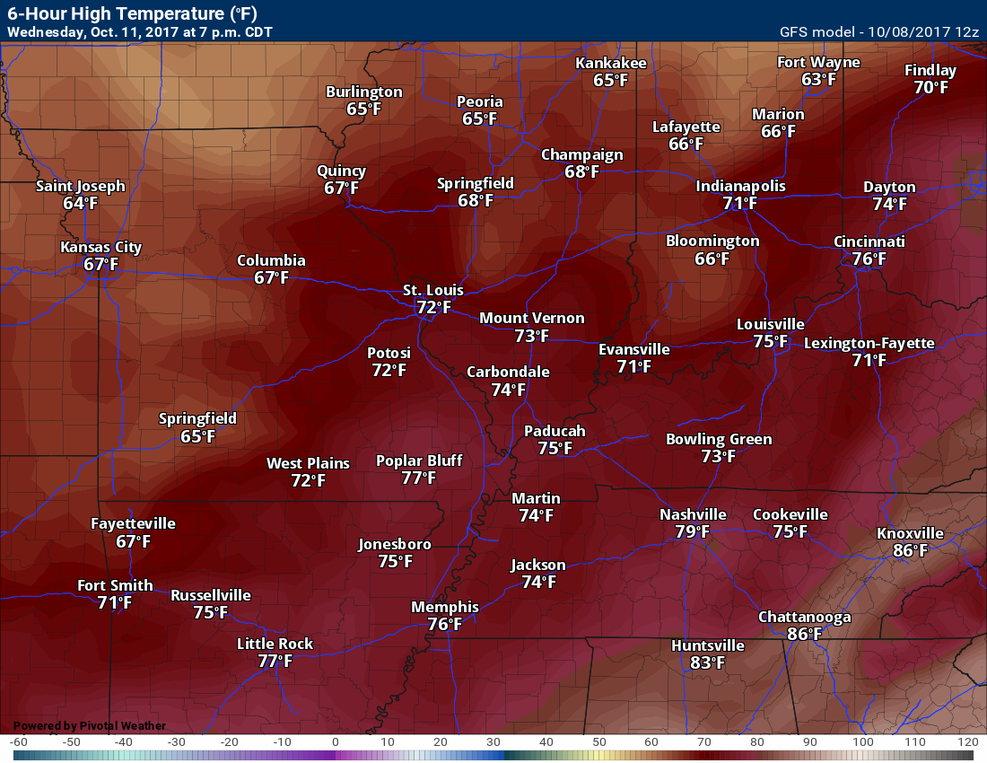
Wednesday Forecast Details
Forecast: Partly to mostly sunny. Cooler. Most likely dry.
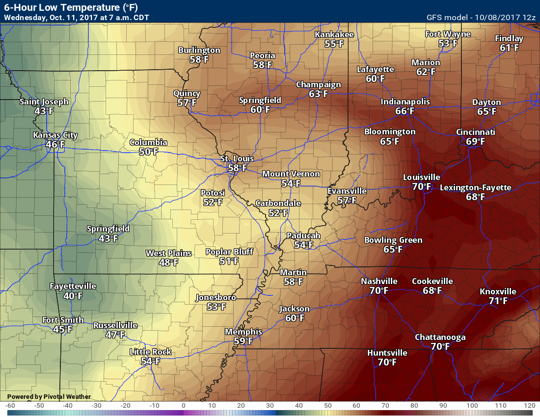
Temperatures: MO ~ 73 to 76 IL ~72 to 75 KY ~ 73 to 76
Winds: West and northwest at 4 to 8 mph
What impacts are anticipated from the weather? None
My confidence in the forecast verifying: Medium
Is severe weather expected? No
The NWS defines severe weather as 58 mph winds or great, 1″ hail or larger, and/or tornadoes
What is the chance of precipitation? MO ~ 0% IL ~ 0% KY ~ 10%
Coverage of precipitation: None
Should I cancel my outdoor plans? No
.
Wednesday Night Forecast Details:
Forecast: Mostly clear and cooler. Patchy fog possible.
Temperatures: MO ~ 52 to 54 IL ~ 52 to 54 KY ~ 52 to 54
Winds: Northwest winds at 0 to 5 mph.
What impacts are anticipated from the weather? Perhaps patchy fog with lower visibility.
My confidence in the forecast verifying: High
Is severe weather expected? No
The NWS defines severe weather as 58 mph winds or great, 1″ hail or larger, and/or tornadoes
What is the chance of precipitation? MO ~ 0% IL ~ 0% KY ~ 10%
Coverage of precipitation: None
Should I cancel my outdoor plans? No
.
October 12, 2017
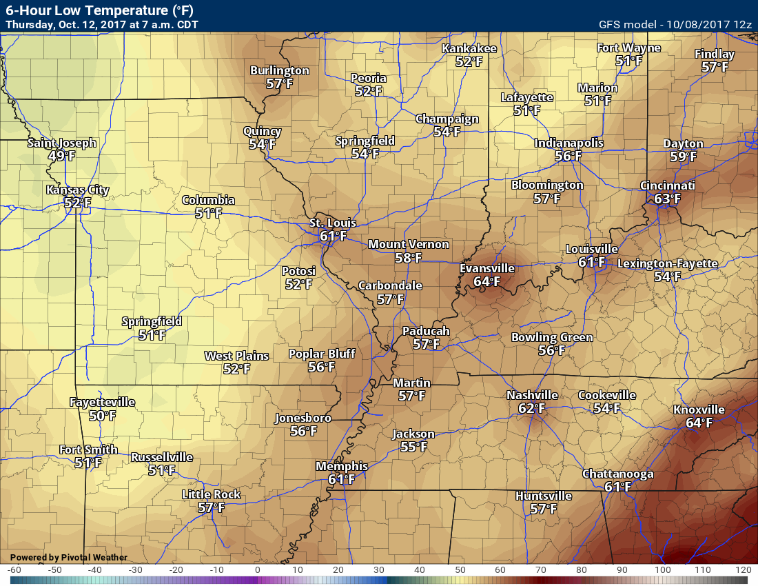
Thursday Forecast Details
Forecast: Mostly sunny. Mild.
Temperatures: MO ~ 75 to 78 IL ~75 to 78 KY ~ 75 to 78
Winds: Variable winds at 4 to 8 mph
What impacts are anticipated from the weather? None.
My confidence in the forecast verifying: High
Is severe weather expected? No
The NWS defines severe weather as 58 mph winds or great, 1″ hail or larger, and/or tornadoes
What is the chance of precipitation? MO ~ 0% IL ~ 0% KY ~ 0%
Coverage of precipitation: Most likely none
Should I cancel my outdoor plans? No
.
Thursday Night Forecast Details:
Forecast: Mostly clear and cool. Patchy fog.
Temperatures: MO ~ 52 to 56 IL ~ 52 to 56 KY ~ 52 to 56
Winds: Variable winds at 0 to 5 mph.
What impacts are anticipated from the weather? Perhaps patchy fog with lower visibility.
My confidence in the forecast verifying: High
Is severe weather expected? No
The NWS defines severe weather as 58 mph winds or great, 1″ hail or larger, and/or tornadoes
What is the chance of precipitation? MO ~ 0% IL ~ 0% KY ~ 0%
Coverage of precipitation: None
Should I cancel my outdoor plans? No
.

The National Weather Service definition of a severe thunderstorm is one that produces quarter size hail or larger, 58 mph winds or greater, and/or a tornado.
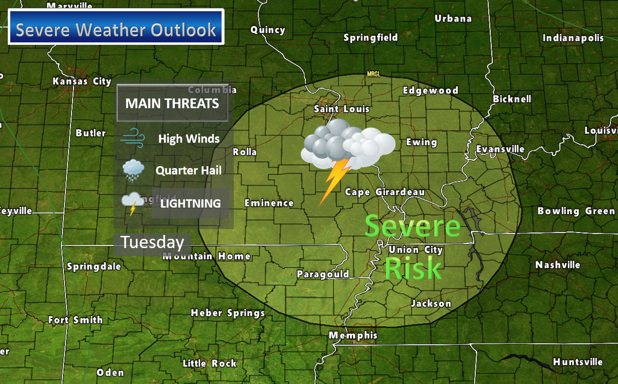
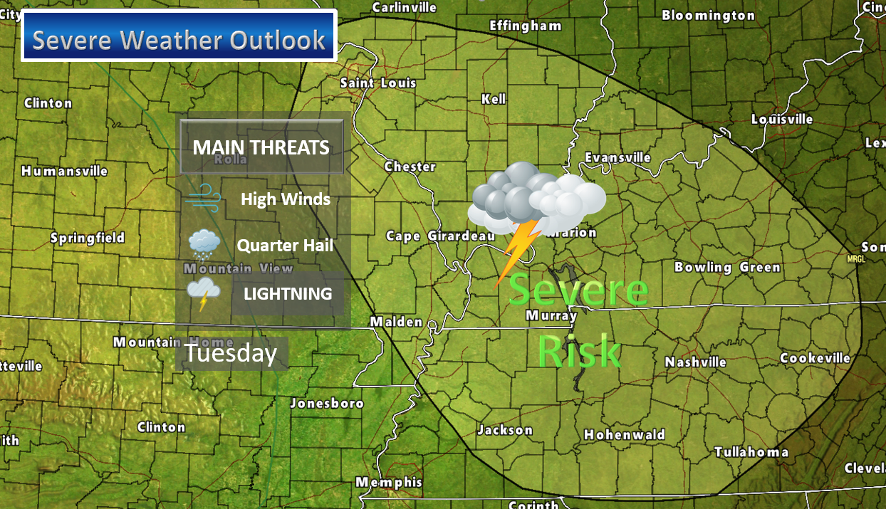
Sunday night through Tuesday: Severe weather is not anticipated Sunday night through Tuesday morning.
There is a conditional risk for severe weather on Tuesday afternoon and evening. If instability develops then all modes of severe weather would be possible. That would include a risk for damaging winds, hail, and isolated tornadoes.
The risk is conditional. Conditional means that there is some question as to whether instability develops.
Monitor updates.
TUESDAY AFTERNOON SEVERE WEATHER OUTLOOK
I will monitor the severe weather risk. Tornado risk is not zero.
.

Overview
Highlights of the forecast.
- Heavy rain ending
- Warm Columbus Day
- Strong to severe storms possible on Tuesday afternoon and evening
- Brief cool-down
Short range comments
Subscribers, sign into your WeatherTalk account and see the latest October forecast. Click here for that information.
(See the long-range discussion further down in this post.
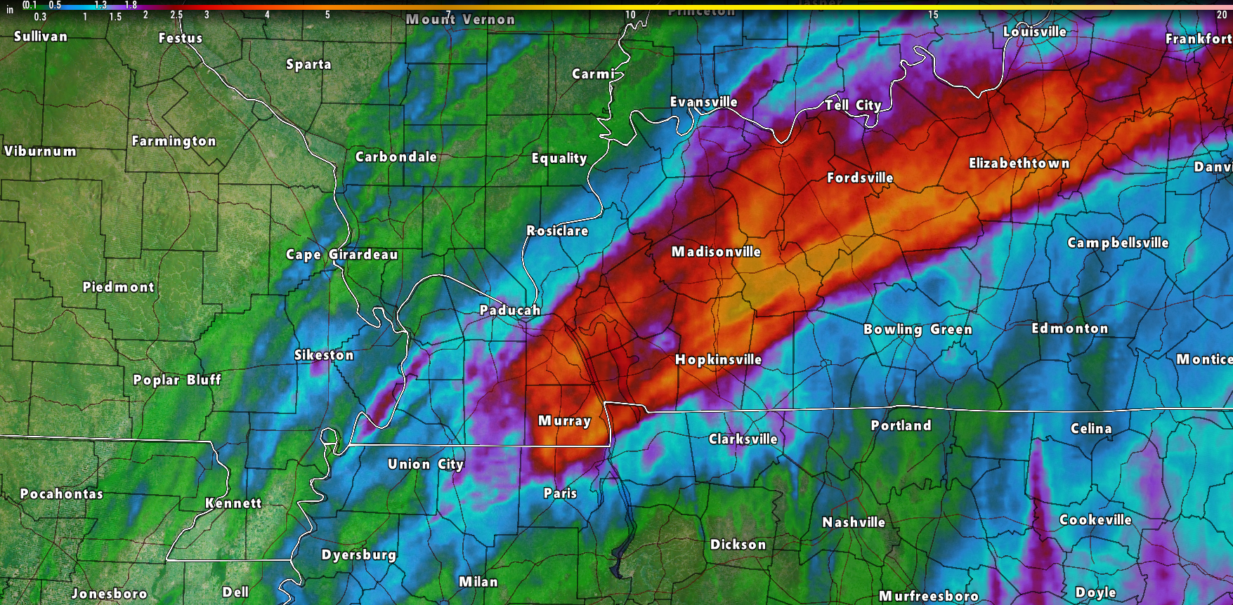
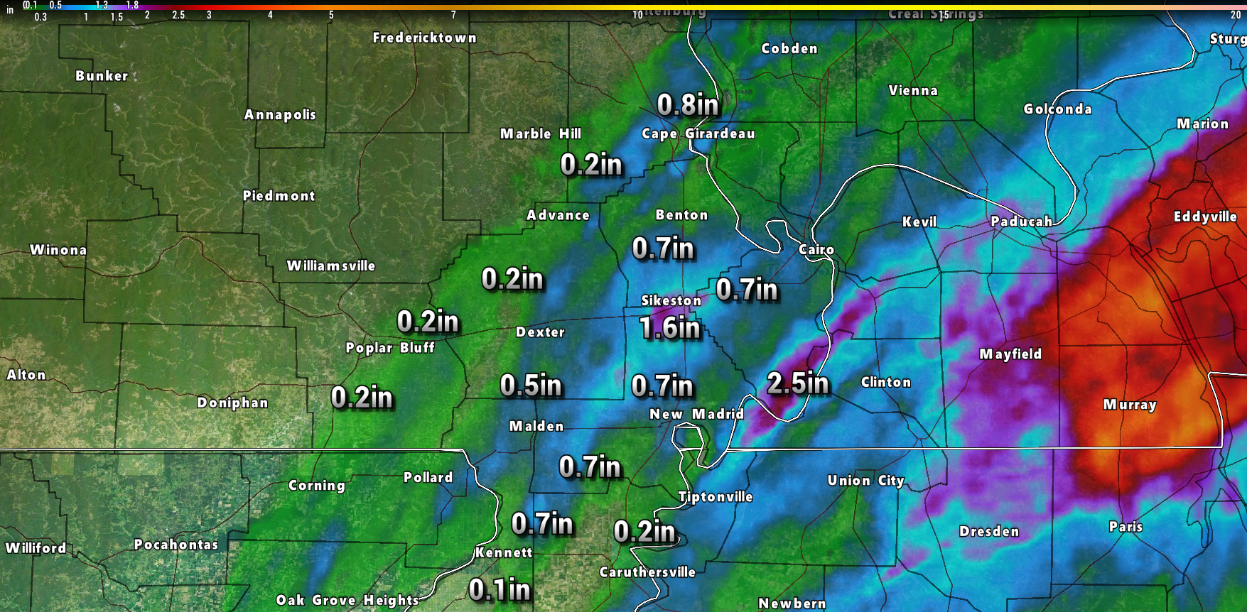
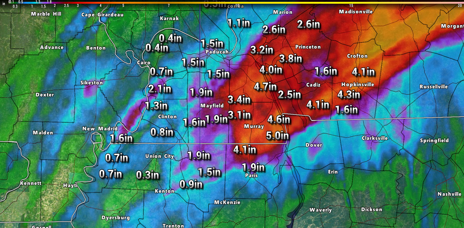
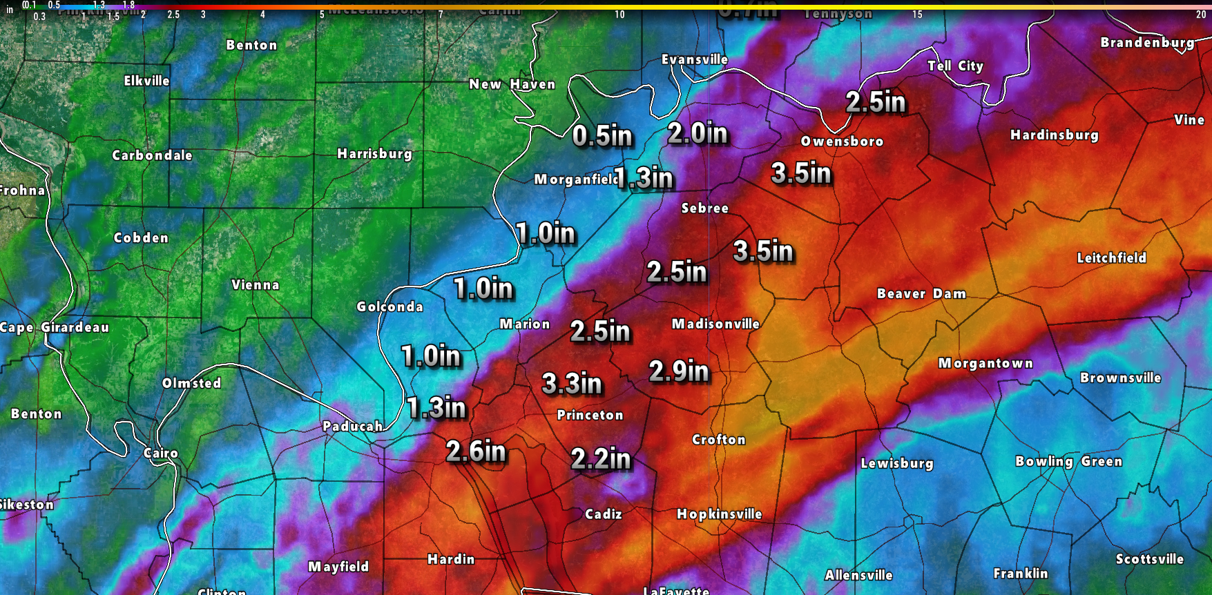
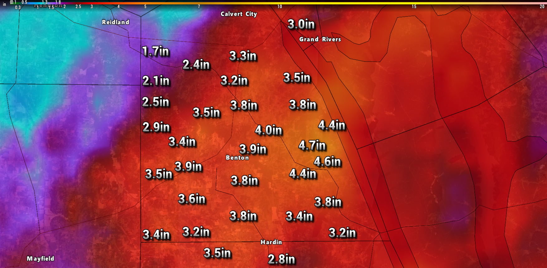
Heavy rain fell across portions of the region. The forecast was for a few spots to pick up three or more inches of rain. That certainly happened. There was also forecast to be a very sharp gradient between the heavy rain and no rain.
Here are some radar estimated rainfall totals.
Regional view. Scale is at the top of the image.
Click images to enlarge them
Illinois rainfall totals
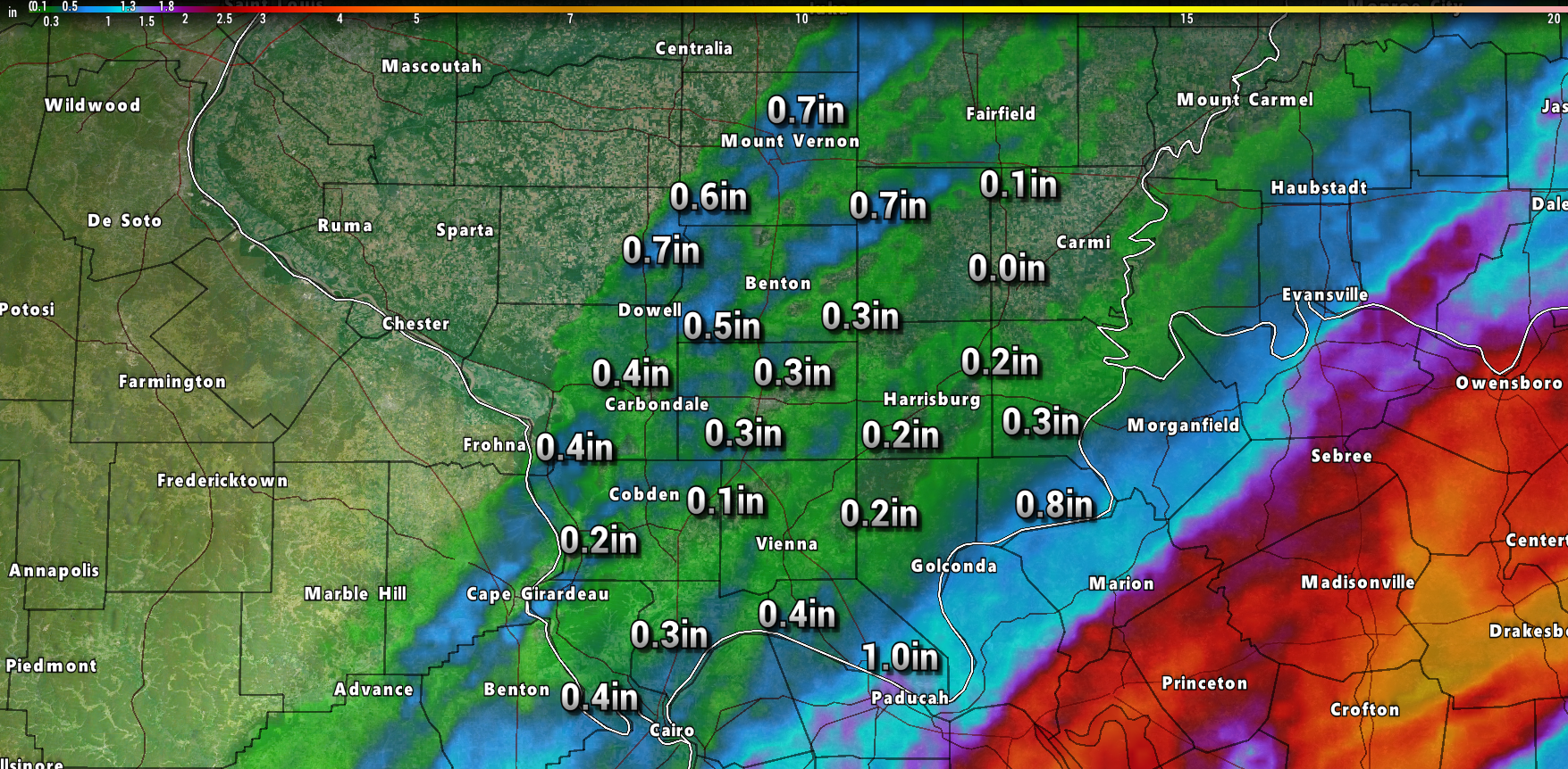
Missouri rainfall totals
West Kentucky and northwest Tennessee rainfall totals (radar estimates)
Northwest Kentucky rainfall totals
Zoomed in on western Kentucky
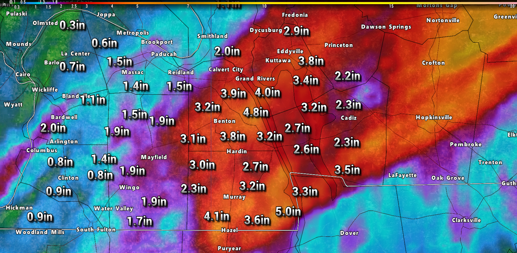
Marshall County zoom
The heavy rain is on the way out.
We will have to deal with dense fog tonight. Visibility may be reduced in many areas. Use care if you have to travel later tonight into Monday morning.

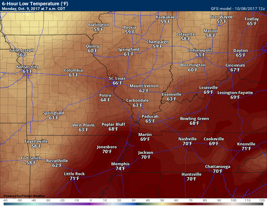
Lows will be well above normal. You can expect 60’s for most of the region.
Monday and Monday night
There will be a chance of isolated showers or thunderstorms on Monday, but most areas will remain dry. Not overly concerned about rain being an issue on Monday (during the day).
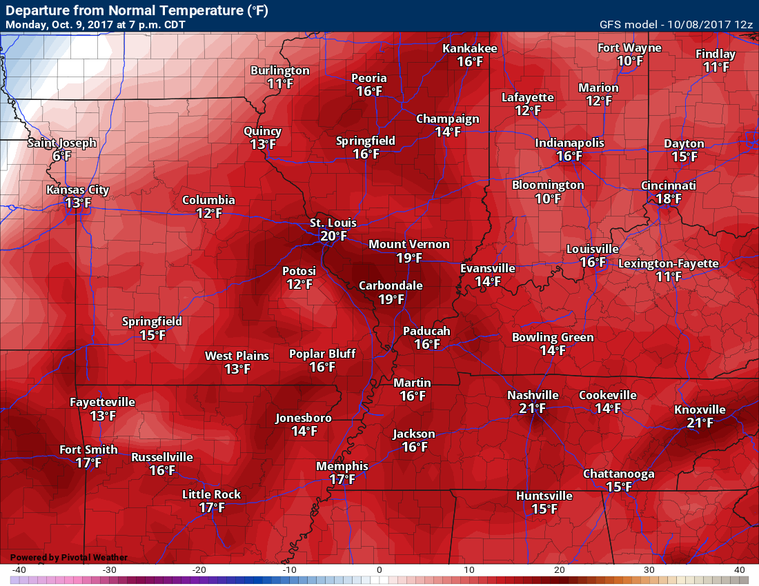
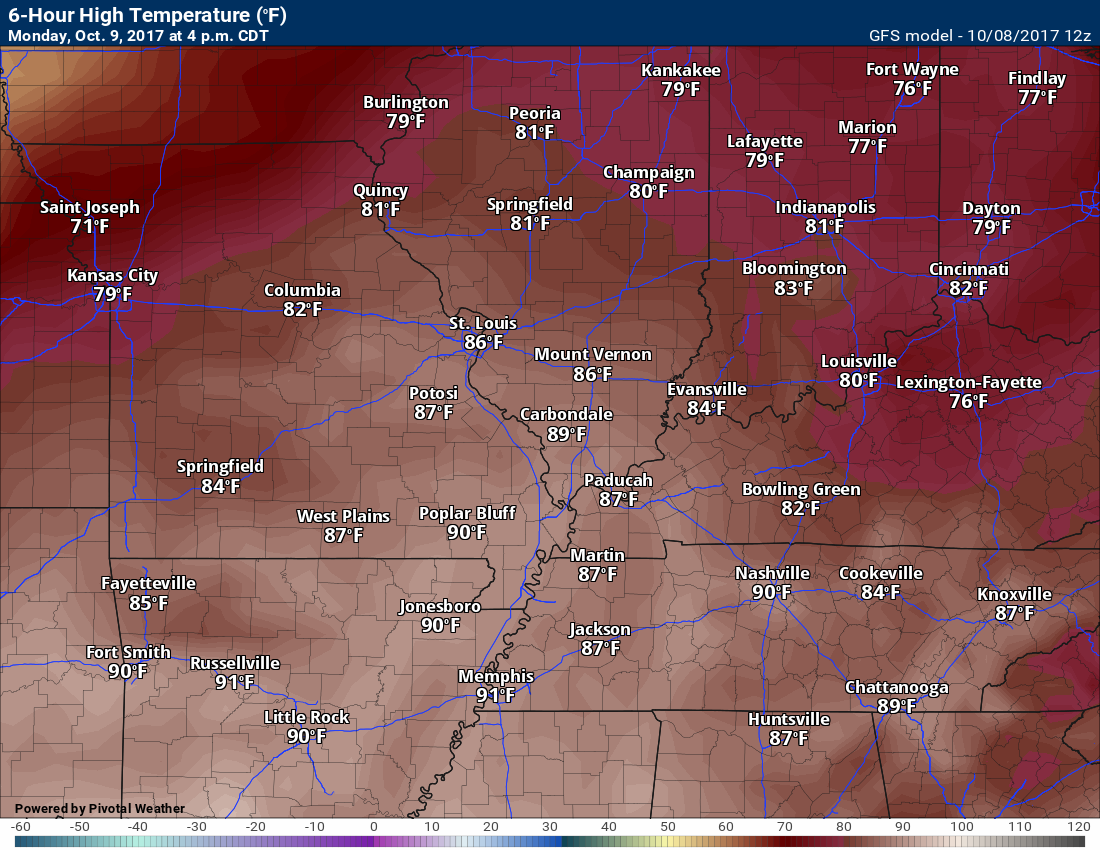
It will be very warm on Monday. Temperatures will be well above normal. You can expect highs in the 83 to 86 degree range (locally higher).
Normal high temperatures, for this time of the year, are around 73 to 75 degrees.
Here is the Monday temperature anomaly map. How many degrees above normal will it be?
Click images to enlarge
Impressive anomalies. Par for the course.
Monday night
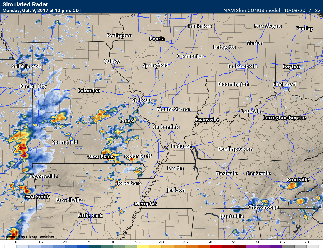
A warm front will pass through the region. This front will be accompanied by scattered showers and locally heavy thunderstorms. Confidence on Monday night’s forecast is medium.
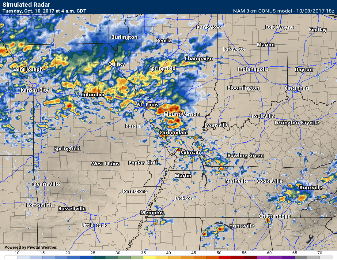
Here is the future-cast radar for Monday night. You can see the western half of the region is where the storms form. The storms would then more northeast.
Click image to enlarge
This is the 10 PM future-cast radar
This is the 4 AM Tuesday morning future-cast radar
This is what radar might look like.
Tuesday and Tuesday night
A cold front will move into the region on Tuesday. I have been watching this front for two weeks. The guidance has gone back and forth with the intensity of the system. Earlier this weekend it appeared that severe weather might not be a concern. That has now changed.
Trends are pointing towards a conditional severe weather threat. What does a conditional threat mean? It means that in order to have severe weather we are going to need CAPE. CAPE is basically energy for thunderstorms. CAPE is instability.
If CAPE does not develop, then severe weather won’t be a concern. If CAPE does develop, then severe storms are possible.
Large hail, damaging winds, frequent lightning, and isolated tornadoes will be possible if instability (CAPE) develops on Tuesday.
The time frame of concern will be between 3 pm and 9 pm.
Monitor updates concerning Tuesday’s weather.
Let’s look at a few maps for Tuesday afternoon. I am using the NAM model guidance.
The window for severe weather to develop is small. I am watching mid-afternoon into mid-evening. That would be around 2 or 3 pm through 9 pm.
Click images to enlarge
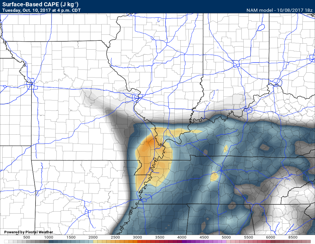
This is the CAPE forecast for Tuesday afternoon/evening. As you can see, we do have numbers spiking over at least a portion of our region. Cloud cover will be key to Tuesday’s forecast. More cloud cover will help keep CAPE (instability) numbers lower.
Just not sure, yet. We will need to monitor Tuesday’s forecast data.
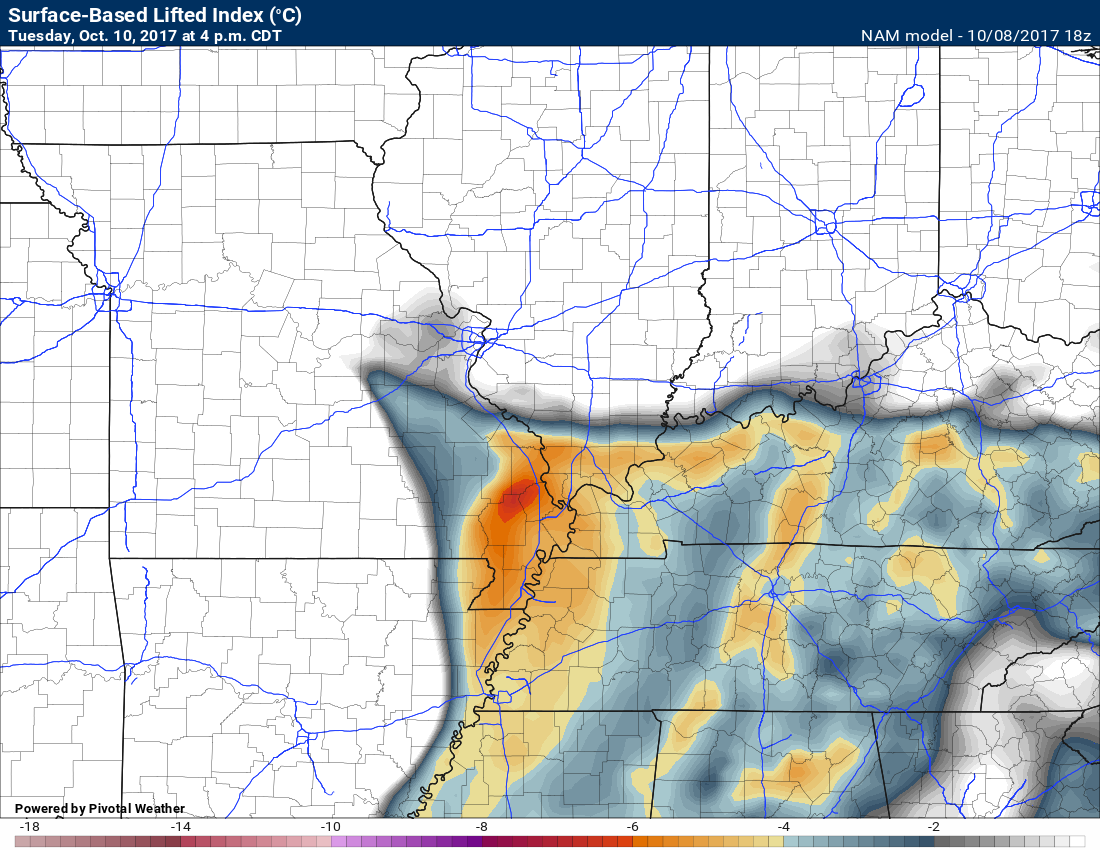
This is the lifted index forecast. Lifted index is another parameter that meteorologists use to forecast severe weather. Negative numbers would mean the atmosphere is unstable.
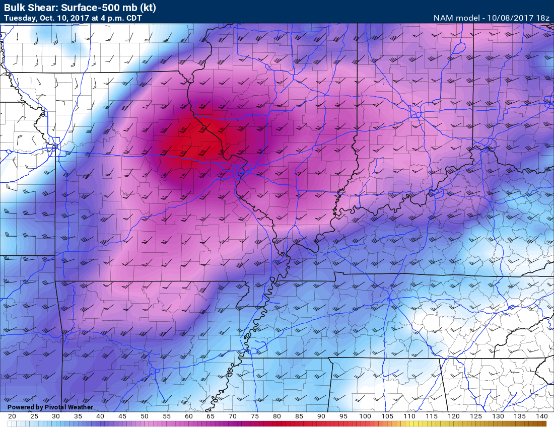
Wind shear will be present on Tuesday afternoon. Wind shear is another ingredient for severe thunderstorms. Winds aloft will be turning and speeding up. Both of those factors equal wind shear.
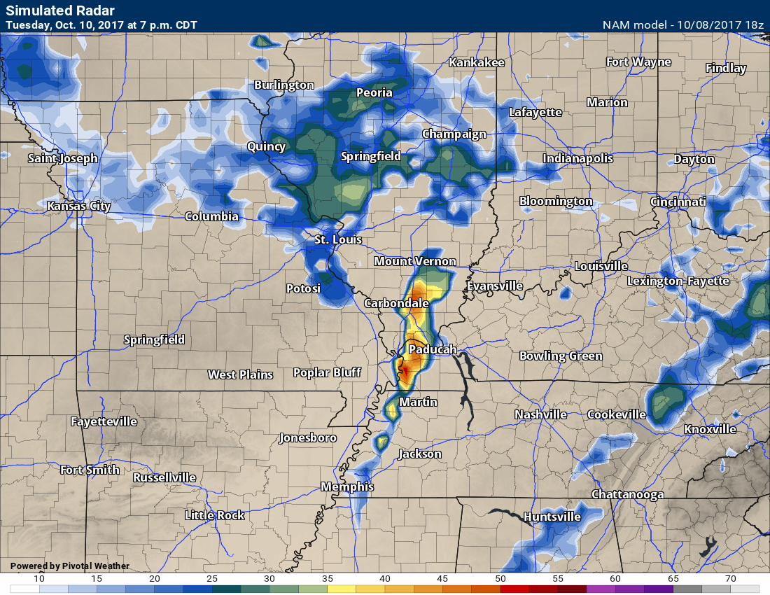
The future-cast radar for 7 pm on Tuesday does show a line of storms in the region.
Keep in mind, this is still a low confidence forecast. This is one model’s opinion on what might happen on Tuesday.
Wednesday and Thursday should be dry. It will be somewhat cooler. Highs may remain in the 70’s on both days.
Some of the guidance attempts to paint a shower or two on Wednesday. I am going to keep the forecast dry, for now. I will monitor trends.
We warm back up again by Friday into the weekend. The 80’s will return. This is an amazing stretch of warm weather.
Where is fall?
Temperature Forecast
Sunday night low temperatures
Monday high temperatures
Monday night low temperatures
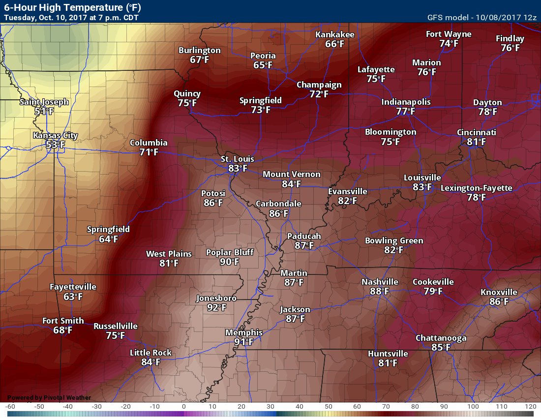
Tuesday high temperatures
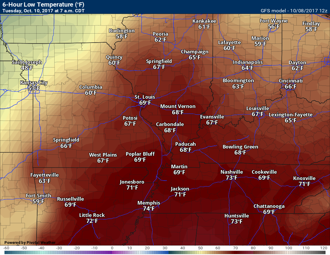
Tuesday night low temperatures
Wednesday high temperatures
Wednesday night low temperatures
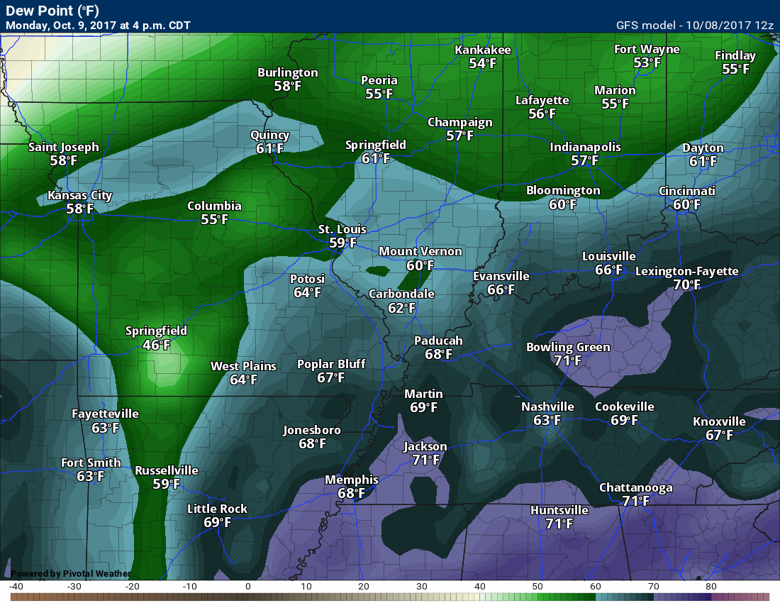
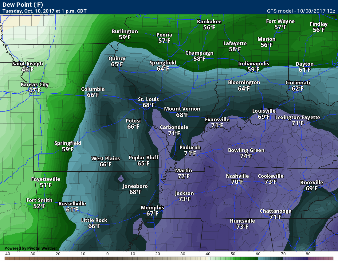
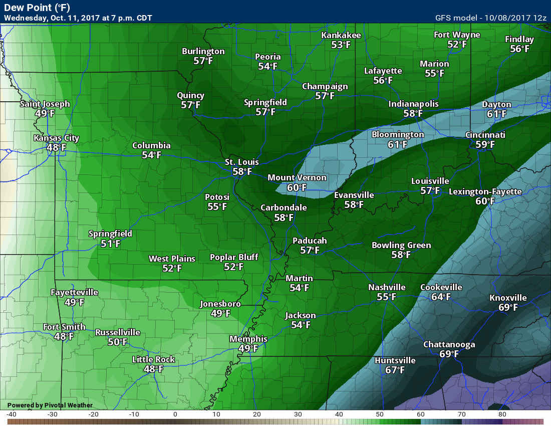
Dewpoint scale
Dew points are what control how you feel outside.

Monday dew points
Tuesday dew points
Wednesday dew points
Long range forecast discussion
We will warm back into the 80’s by next Friday into the weekend. Well above normal temperatures.
Are you subscribing to Weather Talk app/text messages and videos? This is what helps support all of the data you see each day.
We now offer premium videos for the short and long-range forecasts! These videos are produced by a team of long range forecast experts. They are brought to you as bonus information. Activate text option four in order to receive these on your app or via text.
Subscribe at www.beaudodsonweather.com
We offer an Apple and Android app (scroll to the bottom of this page for more information).

Were you aware that I hired a team of meteorologists for long range videos?
To learn more, click this link
http://cms.weathertalk.com/meet-the-team/
.


We offer regional radars and local city radars – if a radar does not update then try another one. Occasional browsers need their cache cleared. You may also try restarting your browser. This will usually fix any problems.
During the winter you can track snow and ice by clicking the winterize button on the local city view interactive radars.
You may email me at beaudodson@usawx.com
Interactive Weather Radar Page. Choose the city nearest your location: Click this link
National interactive radar: Click this link.
The Beau Dodson Weather APP is ready for Apple and Android users. The app provides a faster way for you to receive my text messages. ATT and Verizon are not always reliable when it comes to speed.
Some of you have asked if you can receive the texts on your phone and the app. The answer to that is, yes. The Android app will automatically allow that to happen. On the Apple app, however, you will need to open your app and click the settings button. Make sure the green tab is OFF. Off means you will still receive the texts to your phone and the app. If you have any questions, then email me at beaudodson@usawx.com
The app is for text subscribers.
The direct download, for the Apple app, can be viewed here
https://itunes.apple.com/us/app/id1190136514
Here is the download link for the Android version Click Here
If you have not signed up for the texting service then you may do so at www.beaudodsonweather.com


——————————————————–
Your support helps with the following:

and

.

Whom do you trust for your weather information?
I have studied weather, in our region, since the late 1970’s. I have 40 years of experience in observing our regions weather patterns. My degree is in Broadcast Meteorology and a Bachelor’s of Science.
My resume includes:
Member of the American Meteorological Society.
NOAA Weather-Ready Nation Ambassador.
Meteorologist for McCracken County Emergency Management. I served from 2005 through 2015.
Meteorologist for McCracken County Rescue. 2015 through current
I own and operate the Southern Illinois Weather Observatory.
I am the chief meteorologist for Weather Talk LLC.
I am also a business owner in western Kentucky.
Recipient of the Mark Trail Award, WPSD Six Who Make A Difference Award, Kentucky Colonel, and the Caesar J. Fiamma” Award from the American Red Cross.
In 2005, I helped open the largest American Cross shelter in U.S. history. This was in Houston, Texas. I was deployed to help with the aftermath of Hurricane Katrina and Hurricane Rita. I was a shelter manager of one of the Houston, Texas shelter divisions.
In 2009 I was presented with the Kentucky Office of Highway Safety Award.
Recognized by the Kentucky House of Representatives for my service to the State of Kentucky leading up to several winter storms and severe weather outbreaks.
If you click on the image below you can read the Kentucky House of Representatives Resolution.

I am President of the Shadow Angel Foundation which serves portions of western Kentucky and southern Illinois.
There is a lot of noise on the internet. A lot of weather maps are posted without explanation. You need a trusted source for information.
My forecast philosophy is simple and straight forward.
- Communicate in simple terms
- To be as accurate as possible within a reasonable time frame before an event
- Interact with you on Twitter, Facebook, email, texts, and this blog
- Minimize the “hype” that you might see through other weather sources
- Push you towards utilizing wall-to-wall LOCAL TV coverage during severe weather events

Sign up for my AWARE email by clicking here.
I typically send AWARE emails before severe weather, winter storms, or other active weather situations. I do not email watches or warnings. The emails are a basic “heads up” concerning incoming weather conditions