Today
Severe weather is unlikely today. A few storms could rotate, but odds are that tornadoes won’t form.
These tropical systems can occasionally produce short lived funnels or tornadoes. I will monitor the radars.
Tonight and Monday
Severe weather is unlikely. Lightning will be possible.
Tuesday
Severe thunderstorms are possible on Tuesday. All modes of severe weather will be possible IF instability develops. That is the question on Tuesday. Monitor updates.
Sunday Storm Tracking Tools
Highlights
1. Heavy rain fell overnight (over three inches in Trigg County, KY). See rain totals map below.
2. Banding of rain possible today (could mean high totals for some)
3. Some areas may end up with no significant measurable rain (no change in that part of the forecast)
4. Dense fog tonight and Monday morning
5. Severe storms possible Tuesday
Portions of the region picked up heavy rain last night. I will post two maps below. These are radar indicated totals. They vary GREATLY. Same song and dance as the last few months. Feast or famine weather (that is what I call it).
Bands of showers and thunderstorms will impact the southern half of the region today. That means the greatest chances will be from Poplar Bluff towards Cape Girardeau, Missouri and then into the Marion, Illinois to Evansville, Indiana area. From there southward will have the greatest chance of rain today (although rain is possible further north, as well).
Rain could be heavy. These are tropical downpours brought into the region from Nate. The heaviest showers/storms could produce one inch of rain in thirty to forty minutes.
A few showers possible tonight. Much of the area may dry out tonight. Kentucky has the best rain chances tonight.
Dense fog will form tonight. Drivers use care.
Isolated shower or storm possible on Monday, but most will remain dry.
I am carefully monitoring a developing severe weather setup for Tuesday.
Questions on instability remain. If we have instability then all modes of severe weather will be possible. Confidence, for the time being, is low.
Storm tracking links will be posted below.


.
A Weather Talk subscription ($3 a month) is required to view the videos.
Videos are posted on the www.weathertalk.com website. Once there, click the Beau Video-Cast tab. Long Range Video Update
If you believe you missed a video then you may check the LIVE FEED link on the Weather Talk website. You will find an archive of videos on that page.
You can also receive the videos via your Weather Talk app/text messages. Have text option FOUR activated. The Weather Extra text option. Sign up for the app/text messages, videos, and more at www.beaudodsonweather.com
.
This forecast covers the counties in red. The counties in orange are covered by the forecast discussion further down in the blog.


.
October 7, 2017
Saturday Night Forecast Details:
Forecast: Mostly cloudy. A chance of showers and thunderstorms. Greater chances over extreme southern Illinois and Kentucky. Some feeder bands are possible. Feeder bands will be connected with Hurricane Nate. These bands of rain can produce locally higher rain totals.
Temperatures: MO ~ 56 to 62 IL ~ 56 to 62 KY ~ 60 to 64
Winds: Gusty winds before 8 pm. Winds becoming variable at 5 to 10 mph with gusts to 14 mph
What impacts are anticipated from the weather? Wet roadways and perhaps lightning. Some locally heavy rain possible over western Kentucky.
My confidence in the forecast verifying: Medium
Is severe weather expected? A couple of storms could produce high winds. Tornado risk is low, but not zero.
The NWS defines severe weather as 58 mph winds or great, 1″ hail or larger, and/or tornadoes
What is the chance of precipitation? MO ~ 40% IL ~ 60% KY ~ 70%
Coverage of precipitation: Scattered to numerous. Bands of rain possible.
Should I cancel my outdoor plans? Check radars. Check updates. Rain is possible. Have a plan B.
.
October 8, 2017
Sunday Forecast Details
Forecast: A mix of sun and clouds. More clouds over extreme southern Illinois and Kentucky. Warm for October (except where clouds and rain are occurring). A chance of showers and thunderstorms, especially over Kentucky. Rain chances increase more as you move south and east in the region. Some of the rain could be heavy over western Kentucky.
Temperatures: MO ~ 78 to 84 IL ~78 to 84 KY ~ 75 to 80
Winds: Northeast to east and southeast winds at 6 to 12 mph with gusts to 15 mph
What impacts are anticipated from the weather? Wet roadways and lightning. Locally heavy downpours possible for western Kentucky.
My confidence in the forecast verifying: Medium
Is severe weather expected? Unlikely
The NWS defines severe weather as 58 mph winds or great, 1″ hail or larger, and/or tornadoes
What is the chance of precipitation? MO ~ 40% IL ~ 50% KY ~ 70%
Coverage of precipitation: Isolated to scattered over Missouri and Illinois. More numerous over Kentucky.
Should I cancel my outdoor plans? Check radars and updates. Have a plan B.
.
Sunday Night Forecast Details:
Forecast: Dense fog possible. Mostly cloudy. A chance of rain showers. Small chance for lightning. Best rain chances will likely be over Kentucky.
Temperatures: MO ~ 62 to 64 IL ~ 62 to 64 KY ~ 63 to 66
Winds: Northeast and east wind at 5 to 10 mph with gusts to 14 mph.
What impacts are anticipated from the weather? Wet roadways and perhaps lightning. Low visibility in dense fog.
My confidence in the forecast verifying: High
Is severe weather expected? Not at this time
The NWS defines severe weather as 58 mph winds or great, 1″ hail or larger, and/or tornadoes
What is the chance of precipitation? MO ~ 20% IL ~ 30% KY ~ 50%
Coverage of precipitation: Scattered. Greatest coverage would likely be over Kentucky.
Should I cancel my outdoor plans? Monitor updates. Have a plan B for Kentucky.
.
October 9, 2017
Monday Forecast Details
Forecast: Morning clouds, especially for western Kentucky. Becoming partly sunny. Very warm for October. Isolated showers and thunderstorms possible. Most areas will remain dry.
Temperatures: MO ~ 84 to 86 IL ~84 to 86 KY ~ 84 to 86
Winds: East and southeast winds at 6 to 12 mph
What impacts are anticipated from the weather? Isolated wet roadways and lightning.
My confidence in the forecast verifying: High
Is severe weather expected? No
The NWS defines severe weather as 58 mph winds or great, 1″ hail or larger, and/or tornadoes
What is the chance of precipitation? MO ~ 10% IL ~ 15% KY ~ 20%
Coverage of precipitation: Isolated
Should I cancel my outdoor plans? No, but perhaps check radars
.
Monday Night Forecast Details:
Forecast: Fog possible. Partly cloudy. Widely scattered showers and thunderstorms. Many areas may remain dry. Well above normal temperatures.
Temperatures: MO ~ 62 to 66 IL ~ 62 to 66 KY ~ 62 to 66
Winds: Variable wind at 5 to 10 mph with higher gusts possible. Winds becoming west and northwest.
What impacts are anticipated from the weather? Lightning. Wet roadways possible.
My confidence in the forecast verifying: Low to Medium.
Is severe weather expected? No
The NWS defines severe weather as 58 mph winds or great, 1″ hail or larger, and/or tornadoes
What is the chance of precipitation? MO ~ 40% IL ~ 40% KY ~ 40%
Coverage of precipitation: Widely scattered.
Should I cancel my outdoor plans? Monitor updates and radars
.
October 10, 2017
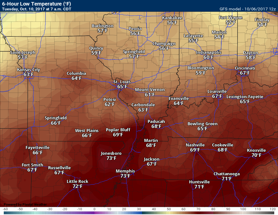
Tuesday Forecast Details
Forecast: Partly cloudy. A few scattered showers and thunderstorms. We will need to monitor for intense storms.
Temperatures: MO ~ 76 to 82 IL ~76 to 82 KY ~ 76 to 82
Winds: East and southeast winds at 4 to 8 mph with gusts to 14. Winds may be variable, at times.
What impacts are anticipated from the weather? Perhaps some wet roadways and lightning. Will monitor the risk for strong storms.
My confidence in the forecast verifying: Low to medium
Is severe weather expected? We may have a risk
The NWS defines severe weather as 58 mph winds or great, 1″ hail or larger, and/or tornadoes
What is the chance of precipitation? MO ~ 40% IL ~ 40% KY ~ 40%
Coverage of precipitation: Widely scattered.
Should I cancel my outdoor plans? No, but check radars.
.
Tuesday Night Forecast Details:
Forecast: Partly cloudy. A chance for evening showers and thunderstorms, then a chance for showers late.
Temperatures: MO ~ 54 to 56 IL ~ 53 to 56 KY ~ 54 to 56
Winds: North and northwest winds at 4 to 8 mph.
What impacts are anticipated from the weather? Wet roadways. Lightning. Monitor the evening hours for perhaps a couple of intense storms.
My confidence in the forecast verifying: Low to medium
Is severe weather expected? Monitor the evening hours.
The NWS defines severe weather as 58 mph winds or great, 1″ hail or larger, and/or tornadoes
What is the chance of precipitation? MO ~ 30% IL ~ 30% KY ~ 30%
Coverage of precipitation: Widely scattered
Should I cancel my outdoor plans? No, but monitor updates
.
October 11, 2017
Wednesday Forecast Details
Forecast: Partly sunny. Cooler. A slight chance of showers.
Temperatures: MO ~ 74 to 76 IL ~72 to 76 KY ~ 74 to 76
Winds: Northwest at 4 to 8 mph
What impacts are anticipated from the weather? None to isolated wet roadways.
My confidence in the forecast verifying: Medium
Is severe weather expected? No
The NWS defines severe weather as 58 mph winds or great, 1″ hail or larger, and/or tornadoes
What is the chance of precipitation? MO ~ 20% IL ~ 20% KY ~ 20%
Coverage of precipitation: None to isolated
Should I cancel my outdoor plans? No
.
Wednesday Night Forecast Details:
Forecast: Evening clouds. Then becoming mostly clear and cooler. Patchy fog possible.
Temperatures: MO ~ 52 to 54 IL ~ 52 to 54 KY ~ 52 to 54
Winds: Northwest winds at 5 mph.
What impacts are anticipated from the weather? Perhaps patchy fog with lower visibility.
My confidence in the forecast verifying: Medium
Is severe weather expected? No
The NWS defines severe weather as 58 mph winds or great, 1″ hail or larger, and/or tornadoes
What is the chance of precipitation? MO ~ 0% IL ~ 0% KY ~ 10%
Coverage of precipitation: None
Should I cancel my outdoor plans? No
.
October 12, 2017
Thursday Forecast Details
Forecast: Mostly sunny. Mild.
Temperatures: MO ~ 75 to 78 IL ~75 to 78 KY ~ 75 to 78
Winds: Variable winds at 4 to 8 mph
What impacts are anticipated from the weather? None.
My confidence in the forecast verifying: High
Is severe weather expected? No
The NWS defines severe weather as 58 mph winds or great, 1″ hail or larger, and/or tornadoes
What is the chance of precipitation? MO ~ 0% IL ~ 0% KY ~ 0%
Coverage of precipitation: Most likely none
Should I cancel my outdoor plans? No
.
Thursday Night Forecast Details:
Forecast: Mostly clear and cool. Patchy fog.
Temperatures: MO ~ 52 to 56 IL ~ 52 to 56 KY ~ 52 to 56
Winds: Variable winds at 0 to 5 mph.
What impacts are anticipated from the weather? Perhaps patchy fog with lower visibility.
My confidence in the forecast verifying: High
Is severe weather expected? No
The NWS defines severe weather as 58 mph winds or great, 1″ hail or larger, and/or tornadoes
What is the chance of precipitation? MO ~ 0% IL ~ 0% KY ~ 0%
Coverage of precipitation: None
Should I cancel my outdoor plans? No
.

The National Weather Service definition of a severe thunderstorm is one that produces quarter size hail or larger, 58 mph winds or greater, and/or a tornado.
Saturday night through Tuesday: A few storms could produce gusty winds Saturday night and Sunday. The risk for severe weather is low, but perhaps not zero. A non-zero tornado risk, as well. A few storms will rotate.
Lightning is possible on Saturday night into Monday.
I am monitoring Tuesday afternoon and evening for strong storms. Low confidence.
Locally heavy rain is possible for portions of western Kentucky.
.

Overview
Highlights of the forecast.
- Tropical rains, for some.
- Several cold fronts to monitor
- Cooler by the middle of next week
- Warming trend late week. Back to above normal readings!
Short range comments
Subscribers, sign into your WeatherTalk account and see the latest October forecast. Click here for that information.
(See the long-range discussion further down in this post)
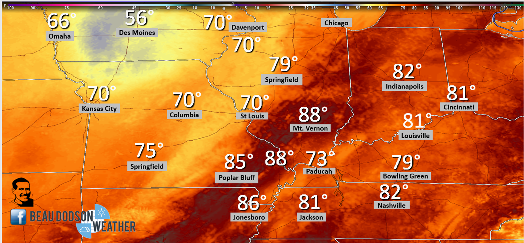
There was a wide range of temperatures Saturday afternoon. Clouds and rain made all the difference.
Here was the 2 PM temperature map (Saturday)
Saturday night into Monday
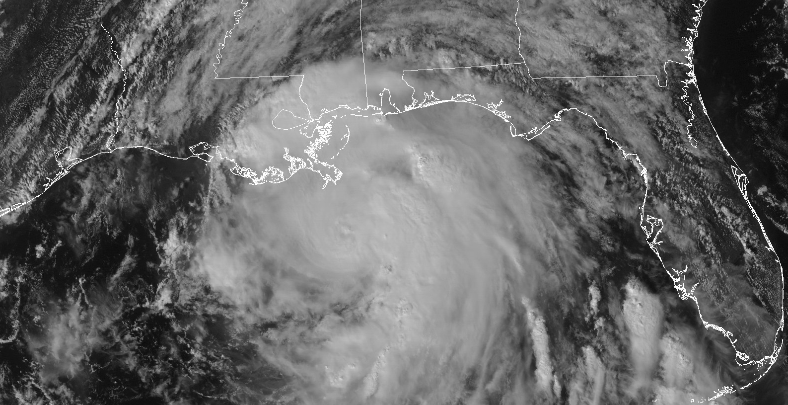
The main concern will be the remnants of Nate. Tropical rains are possible across portions of our region. In particular, western Kentucky.
Nate was gaining strength on Saturday afternoon and will likely hit the coast as a category two hurricane. Winds of 100 mph+ are possible in the eye-wall.
Heavy rain and isolated tornadoes will occur along its path.
Here is a Saturday evening satellite image of Nate
Click to enlarge
The big question, for our local area, will be where do rain bands set up. These rain bands will produce locally heavy rain totals in excess of two or three inches.
The odds increase as you travel south and east in the region. That means Kentucky has a better chance of heavy rain than southeast Missouri and southern Illinois.
The track of Nate is key to the heavy rain potential. A second piece of the puzzle is a weakening cold front advancing into the region.
Showers and thunderstorms will continue into Saturday night into Sunday night. The best chance on Sunday and Sunday night will be extreme southern Illinois and then western Kentucky. Lesser chances as you move north and west.
Most of the rain will have ended by Sunday night. A few remaining showers and thunderstorms are possible Sunday night. The best chance would be over western Kentucky.
I can’t completely rule out an isolated shower or thunderstorm on Monday. Most of the area will remain dry. It will be very warm of October. Nothing new. We are used to the warm weather.
A cold front enters our region on Monday night and Tuesday. A few showers will be possible with the front. At this time, the thunderstorm risk appears lower on Monday night/Tuesday morning. Perhaps a few lightning strikes.
I am monitoring Tuesday afternoon/evening for a few heavier storms. Low confidence this far out. Monitor updates.
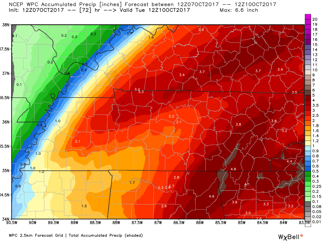
Here is the WPC rainfall forecast graphic. Very sharp cutoff on rain totals. Take the general idea from this graphic and not specifics. In other words, it is unlikely that everyone will receive this much rain.
The general idea is that the heaviest rain will be south and east vs north and west.
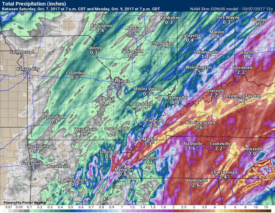
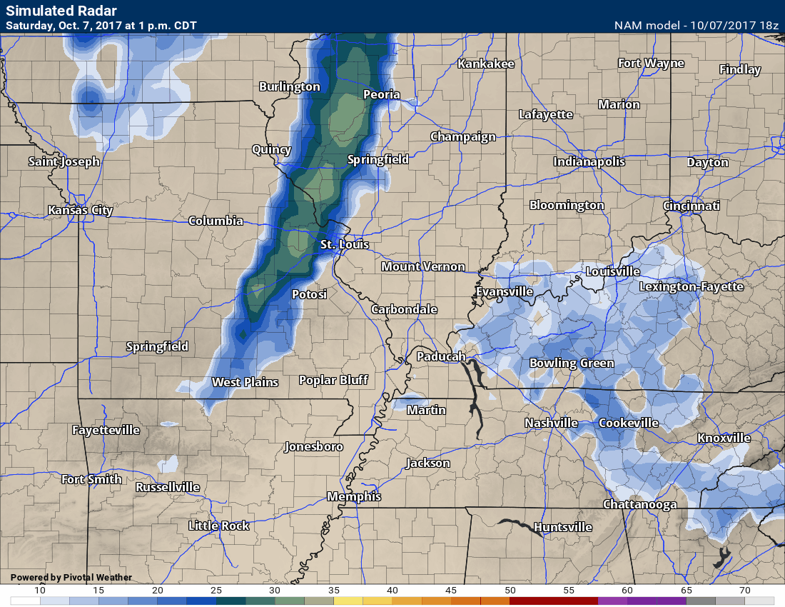
Here is what the NAM model is spitting out for rainfall totals. Notice the coverage. Some banding.
Again, this is not to be taken with specifics. Just take the general idea that the heavier rain will likely end up over portions of Kentucky.
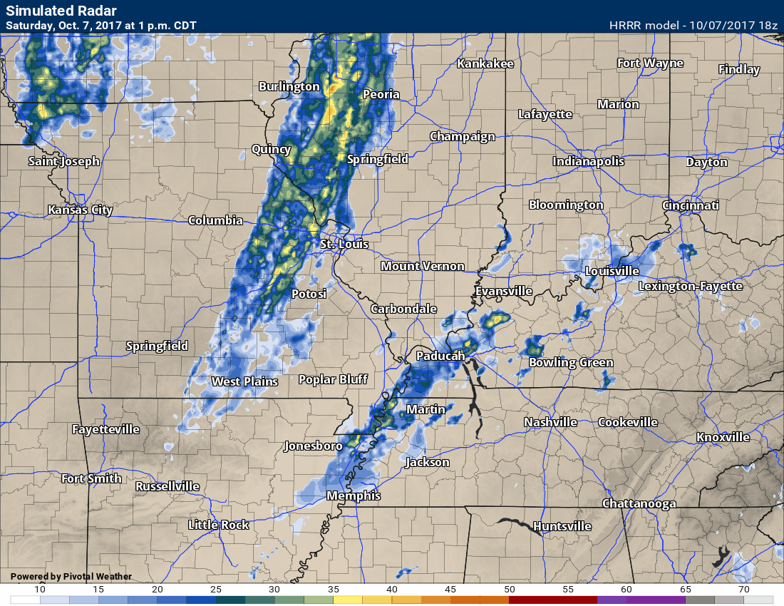
Here is the HRRR model future-cast radar. You can see the time stamp at the top of the animation. Notice how the bands to our south move north and even northwest. That is in response to Nate moving ashore.
Here is the high res 3K NAM model (one model of many).
This is future-cast radar. This is what radar might look like Saturday night into tomorrow. The time stamp is at the top of the image.
Click images to enlarge.
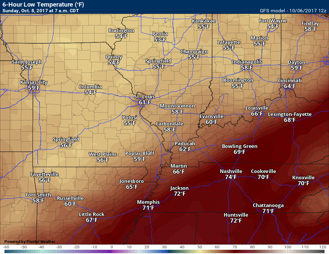
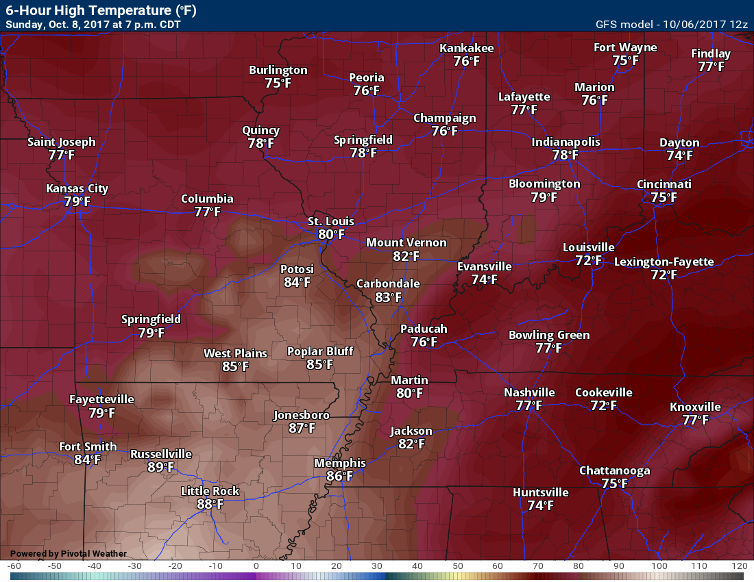
Temperature Forecast
Saturday low temperatures
Sunday high temperatures
Sunday night low temperatures
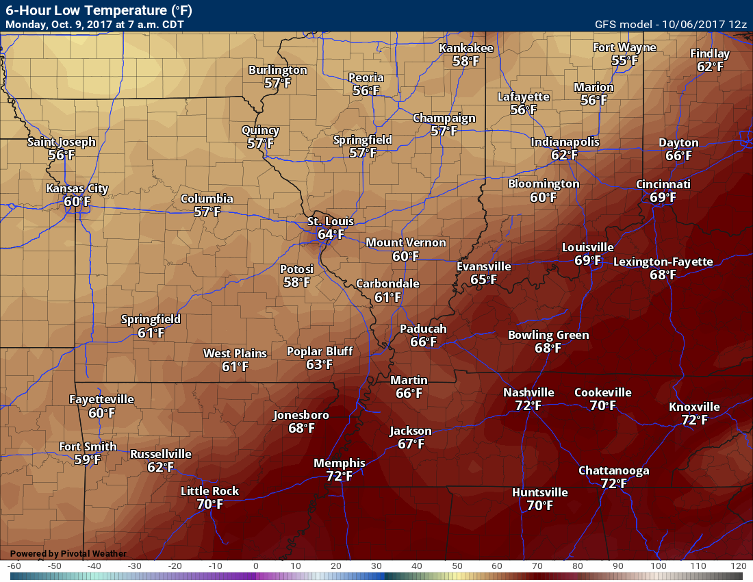
Monday high temperatures
Monday night low temperatures
Dewpoint scale
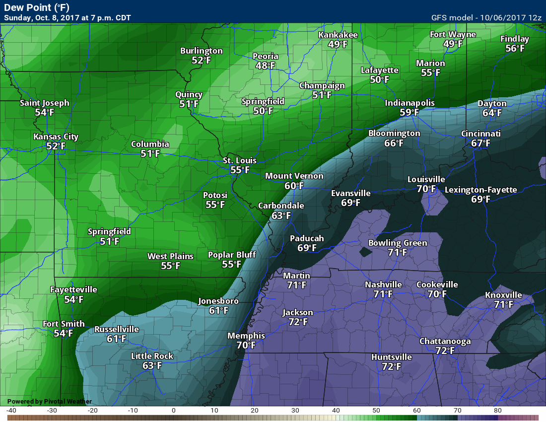
Dew points are what control how you feel outside.

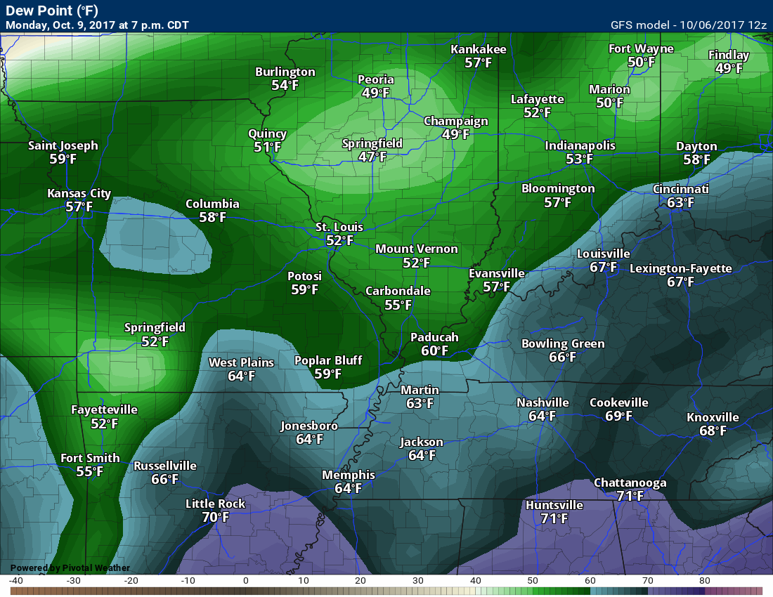
Sunday dew points
These higher dew points are dependent on the track of the tropical system
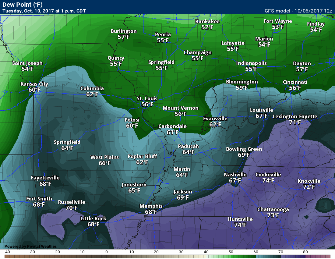
Monday dew points
These higher dew points are dependent on the track of the tropical system
Tuesday dew points
Long range forecast discussion
A cold front will enter the region on Monday night and Tuesday.
This front will deliver a chance of scattered showers and thunderstorms. Some areas may once again pick up little or no rainfall.
Monitor Tuesday for a few stronger storms. Low confidence.
Cooler weather will filter into the region by Tuesday night into Thursday. Model guidance is all over the place with daytime high temperatures on Wednesday, Thursday, and Friday.
For the time being, I have highs in the 70’s for Wednesday and Thursday. GFS model guidance has temperatures in the 80’s.
It does appear we warm back into the 80’s by Friday and Saturday. Our warm fall will continue.
Are you subscribing to Weather Talk app/text messages and videos? This is what helps support all of the data you see each day.
We now offer premium videos for the short and long-range forecasts! These videos are produced by a team of long range forecast experts. They are brought to you as bonus information. Activate text option four in order to receive these on your app or via text.
Subscribe at www.beaudodsonweather.com
We offer an Apple and Android app (scroll to the bottom of this page for more information).

Were you aware that I hired a team of meteorologists for long range videos?
To learn more, click this link
http://cms.weathertalk.com/meet-the-team/
.


We offer regional radars and local city radars – if a radar does not update then try another one. Occasional browsers need their cache cleared. You may also try restarting your browser. This will usually fix any problems.
During the winter you can track snow and ice by clicking the winterize button on the local city view interactive radars.
You may email me at beaudodson@usawx.com
Interactive Weather Radar Page. Choose the city nearest your location: Click this link
National interactive radar: Click this link.
The Beau Dodson Weather APP is ready for Apple and Android users. The app provides a faster way for you to receive my text messages. ATT and Verizon are not always reliable when it comes to speed.
Some of you have asked if you can receive the texts on your phone and the app. The answer to that is, yes. The Android app will automatically allow that to happen. On the Apple app, however, you will need to open your app and click the settings button. Make sure the green tab is OFF. Off means you will still receive the texts to your phone and the app. If you have any questions, then email me at beaudodson@usawx.com
The app is for text subscribers.
The direct download, for the Apple app, can be viewed here
https://itunes.apple.com/us/app/id1190136514
Here is the download link for the Android version Click Here
If you have not signed up for the texting service then you may do so at www.beaudodsonweather.com


——————————————————–
Your support helps with the following:

and

.

Whom do you trust for your weather information?
I have studied weather, in our region, since the late 1970’s. I have 40 years of experience in observing our regions weather patterns. My degree is in Broadcast Meteorology and a Bachelor’s of Science.
My resume includes:
Member of the American Meteorological Society.
NOAA Weather-Ready Nation Ambassador.
Meteorologist for McCracken County Emergency Management. I served from 2005 through 2015.
Meteorologist for McCracken County Rescue. 2015 through current
I own and operate the Southern Illinois Weather Observatory.
I am the chief meteorologist for Weather Talk LLC.
I am also a business owner in western Kentucky.
Recipient of the Mark Trail Award, WPSD Six Who Make A Difference Award, Kentucky Colonel, and the Caesar J. Fiamma” Award from the American Red Cross.
In 2005, I helped open the largest American Cross shelter in U.S. history. This was in Houston, Texas. I was deployed to help with the aftermath of Hurricane Katrina and Hurricane Rita. I was a shelter manager of one of the Houston, Texas shelter divisions.
In 2009 I was presented with the Kentucky Office of Highway Safety Award.
Recognized by the Kentucky House of Representatives for my service to the State of Kentucky leading up to several winter storms and severe weather outbreaks.
If you click on the image below you can read the Kentucky House of Representatives Resolution.

I am President of the Shadow Angel Foundation which serves portions of western Kentucky and southern Illinois.
There is a lot of noise on the internet. A lot of weather maps are posted without explanation. You need a trusted source for information.
My forecast philosophy is simple and straight forward.
- Communicate in simple terms
- To be as accurate as possible within a reasonable time frame before an event
- Interact with you on Twitter, Facebook, email, texts, and this blog
- Minimize the “hype” that you might see through other weather sources
- Push you towards utilizing wall-to-wall LOCAL TV coverage during severe weather events

Sign up for my AWARE email by clicking here.
I typically send AWARE emails before severe weather, winter storms, or other active weather situations. I do not email watches or warnings. The emails are a basic “heads up” concerning incoming weather conditions