Friday morning update
October 6, 2017
Complicated forecast to say the least.
Highlights
1. Warm through Monday (well above normal precipitation)
2. The tropics (NATE)
3. Heavy rain for portions of our region Saturday into Sunday night.
4. Cooler middle/end of next week (40’s for overnight lows may return by the middle of the week)
Today
A mix of sun and clouds with temperatures well into the 80’s. Well above normal temperatures. Southerly winds at 5 to 10 mph with gusts to 12 mph.
Tonight
Gusty winds develop from the south. It will be mild with some increase in clouds. A 30% chance fof a thunderstorm after 1 am for southeast Missouri and southwest Illinois. Less than 20% elsewhere. Winds will gust above 20 mph late tonight
Saturday into Sunday night
Increasing clouds. High winds likely on Saturday. Boaters use care. Southerly winds 20 to 40 mph.
Scattered showers and thunderstorm possible in the morning and early afternoon. This will occur along an incoming cold front that will stall over our region.
The front will be moving west to east.
Best rain/storms chances before 11 am will be over southeast Missouri and southern Illinois.
Increasing chances for more organized rain as we push deeper into the afternoon hours for western Kentucky. This will be in response to tropical storm/hurricane Nate.
The rain during the afternoon hours will come from the west and south.
Feeder bands of precipitation may develop or be enhanced over our region Saturday afternoon into Sunday night.
Feeder bands will look like bands of rain on radar.
There remain questions on placement and intensity of the rain.
Some guidance is indicating torrential downpours over western Kentucky. Rainfall totals could exceed two inches.
At this time, the greatest rain coverage is anticipated to be from the Missouri Bootheel into Kentucky. Confidence in rainfall totals is lower for southern Illinois.
The southern tip of Illinois would stand somewhat better chances of rain than areas further north and west. This will need to be monitored.
Severe weather is currently not anticipated.
I should add that some of the guidance is showing four or more inches of rain east of Kentucky Lake.
Occasionally these feeder bands, from tropical systems, can produce copious amounts of rain. This is especially true if training precipitation occurs. Rain moving over the same areas.
Highs on Saturday and Sunday will be in the 80’s. I can’t rule out upper 70’s where clouds and rain are thickest (further east and southeast you travel in the region).
Monday through Tuesday
Scattered rain showers and thunderstorms are possible on Monday, but coverage should be less than Sunday. Best chances on Monday will likely be over Kentucky.
A cold front moves through our region Monday night and Tuesday. This front will spark some showers and thunderstorms over southeast Missouri, southern Illinois, and western Kentucky.
Cooler air should filter into the region by Tuesday into the rest of the week. Overnight lows may dip into the 40’s by Wednesday night. It might feel like fall.
Here are some maps to go along with the above.
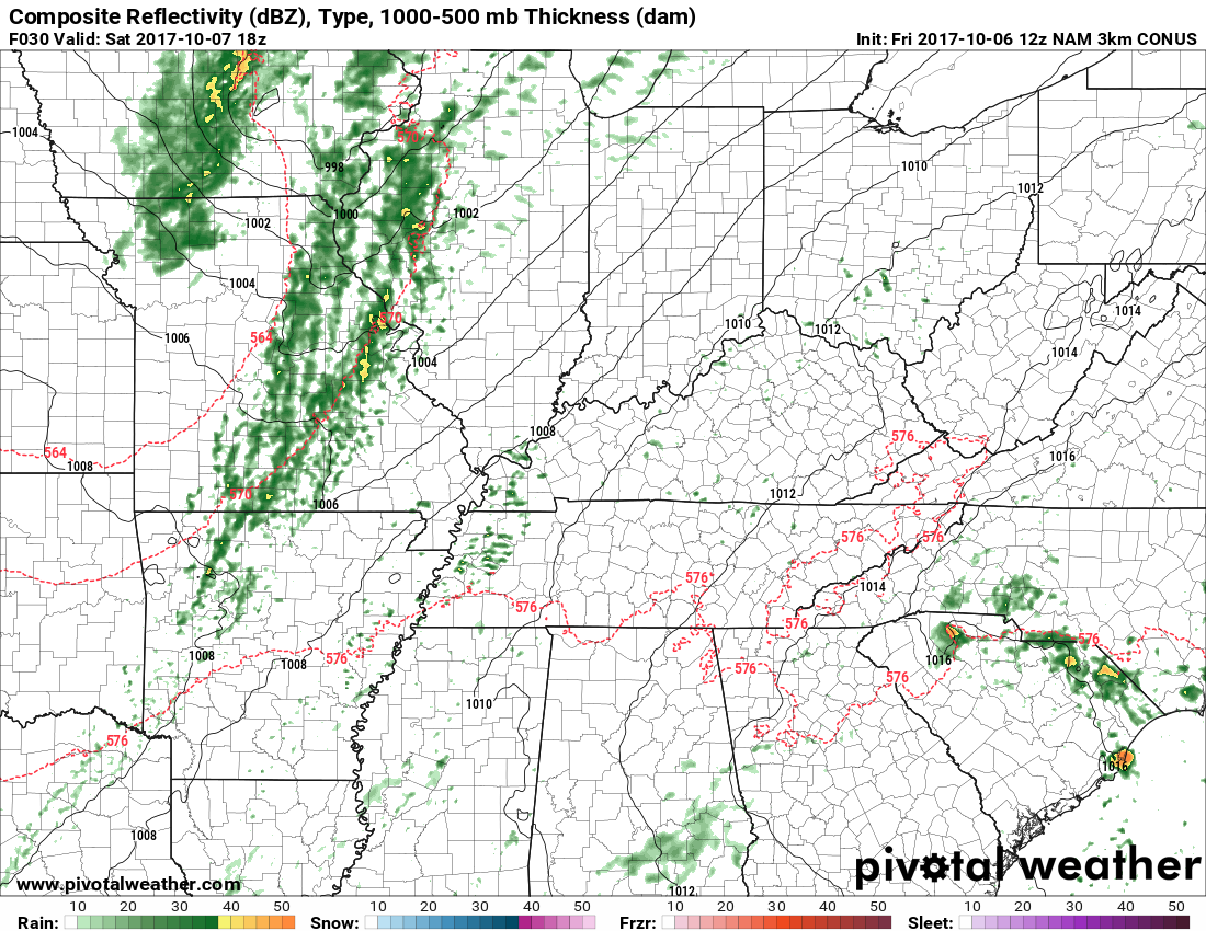
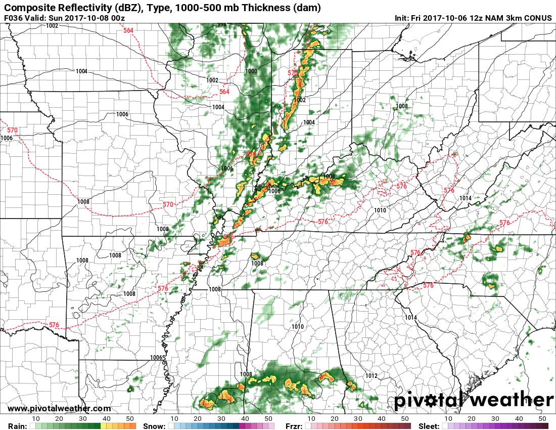
Let’s look at future-cast radar.
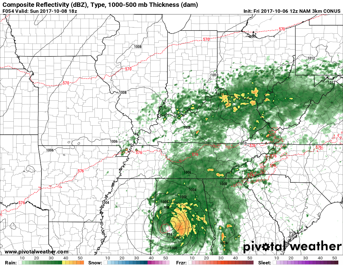
Here is an animation of the NAM model future-cast radar. Tight system that moves ashore on Saturday.
.
.
This is from the NAM guidance. One model of many. This is how it believes radar will unfold into Sunday.
1 PM Saturday
4 PM Saturday
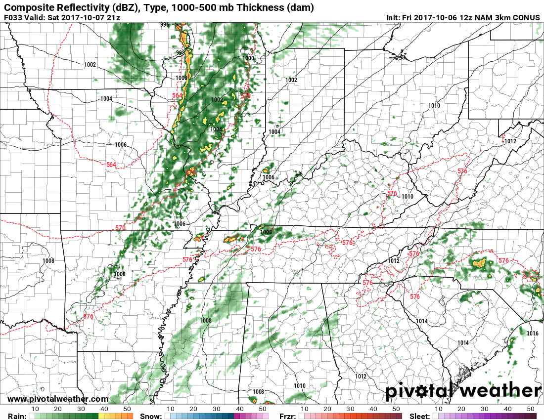
7 PM Saturday
10 PM Saturday
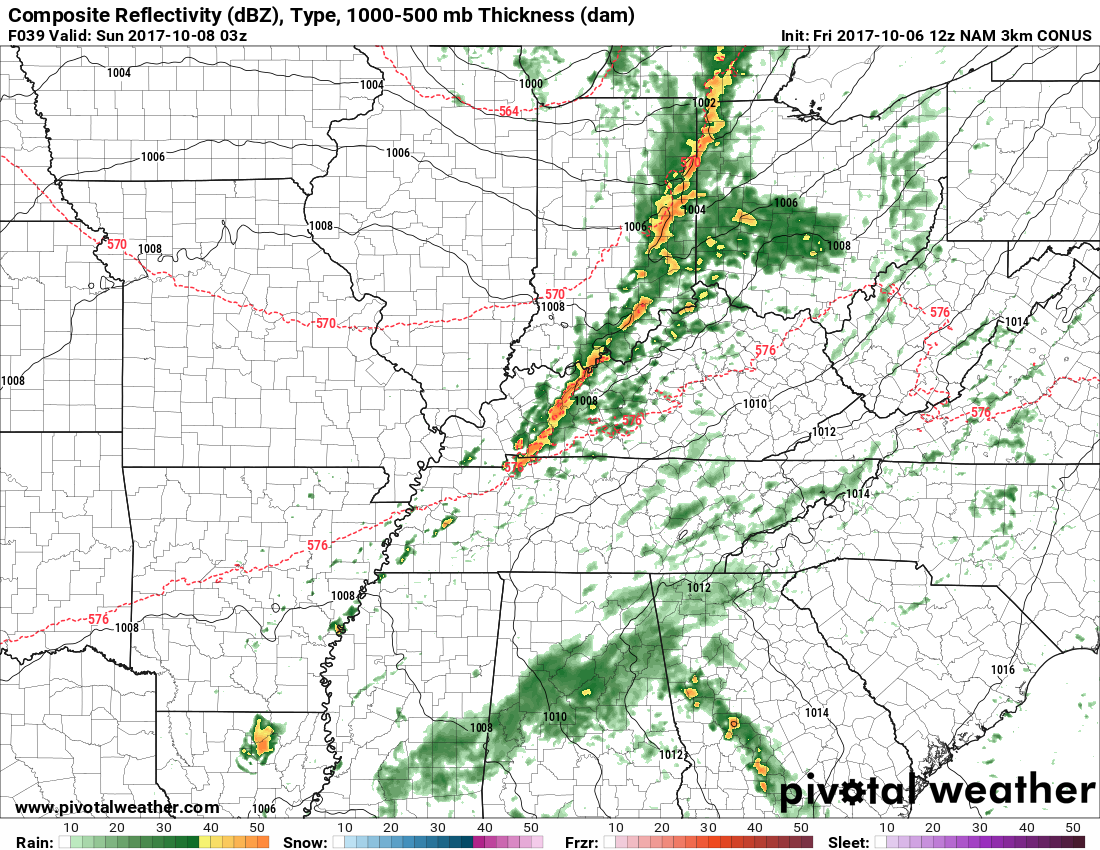
1 AM Sunday
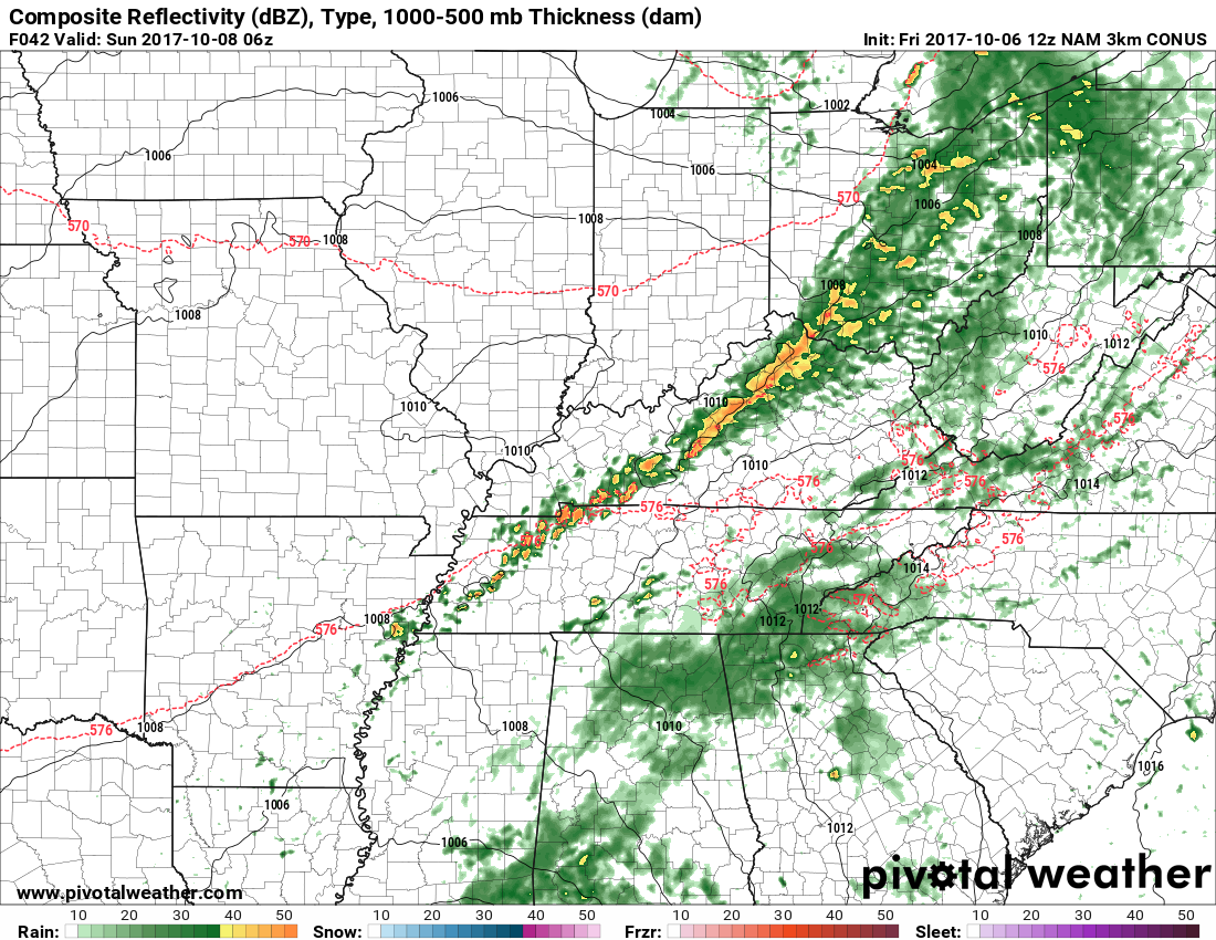
4 AM Sunday
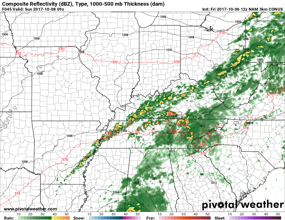
7 AM Sunday
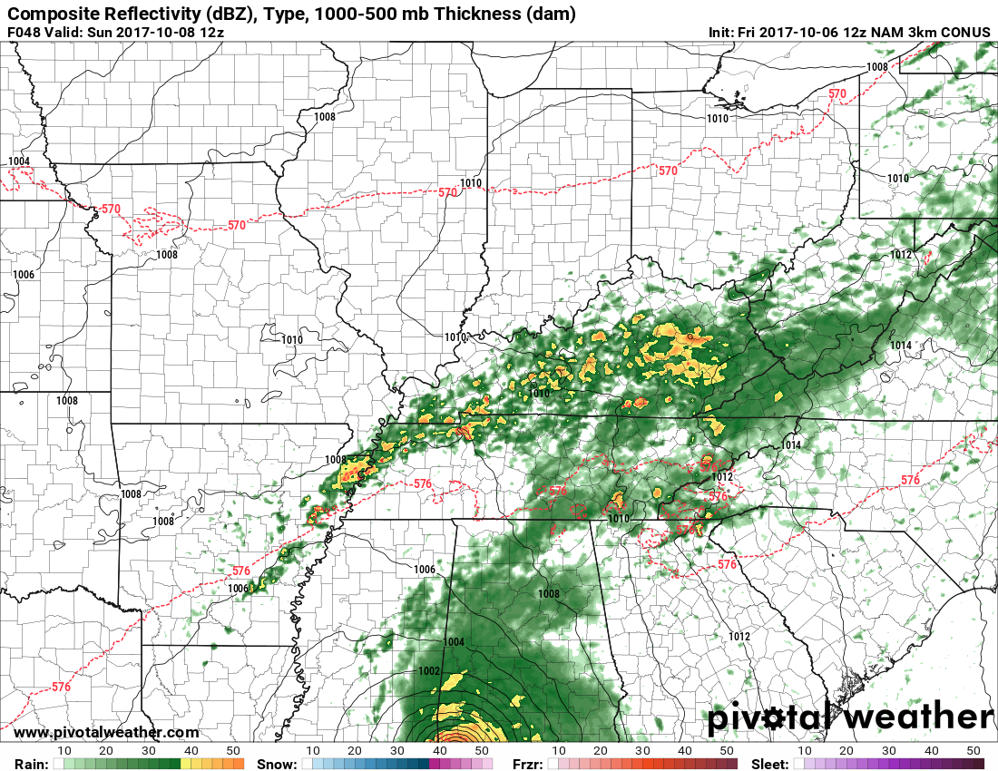
10 AM Sunday
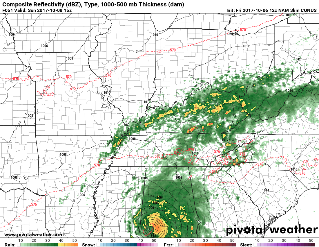
1 PM Sunday
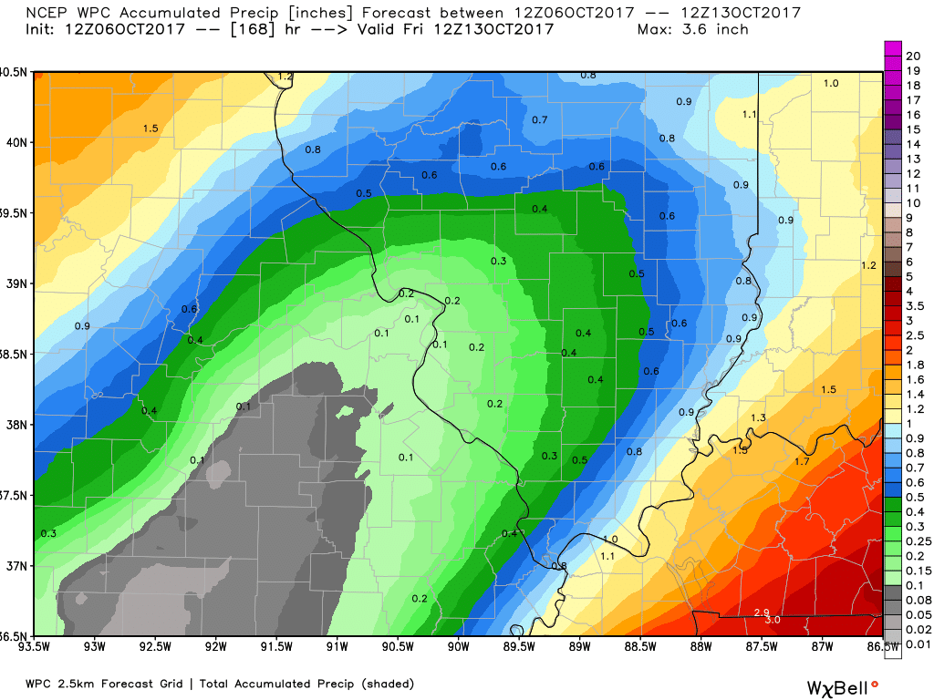
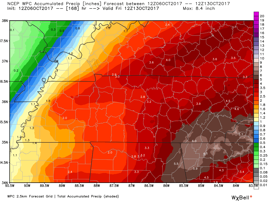
WPC NOAA RAINFALL TOTAL FORECAST
Keep in mind, this is HIGHLY dependent on the track of Nate.
Low confidence on these totals.
SE MO and southern IL view
This is for Friday night through Tuesday
Western KY/TN view
Again, HIGHLY dependent on the track of Nate


.
A Weather Talk subscription ($3 a month) is required to view the videos.
Videos are posted on the www.weathertalk.com website. Once there, click the Beau Video-Cast tab. Long Range Video Update
If you believe you missed a video then you may check the LIVE FEED link on the Weather Talk website. You will find an archive of videos on that page.
You can also receive the videos via your Weather Talk app/text messages. Have text option FOUR activated. The Weather Extra text option. Sign up for the app/text messages, videos, and more at www.beaudodsonweather.com
.
This forecast covers the counties in red. The counties in orange are covered by the forecast discussion further down in the blog.


.
October 5, 2017
Thursday Night Forecast Details:
Forecast: Partly to mostly cloudy. Mild for October. Well above normal temperatures. More clouds MO/IL vs KY/TN
Temperatures: MO ~ 60 to 64 IL ~ 60 to 64 KY ~ 60 to 64
Winds: South at 0 to 5 mph
What impacts are anticipated from the weather? Most likely none
My confidence in the forecast verifying: Medium
Is severe weather expected? No
The NWS defines severe weather as 58 mph winds or great, 1″ hail or larger, and/or tornadoes
What is the chance of precipitation? MO ~ 10% IL ~ 10% KY ~ 5%
Coverage of precipitation: Most likely none.
Should I cancel my outdoor plans? No
.
October 6, 2017
Friday Forecast Details
Forecast: Partly cloudy. Very warm for October. Well above normal temperatures. More clouds MO/IL vs KY/TN
Temperatures: MO ~ 85 to 88 IL ~85 to 88 KY ~ 85 to 88
Winds: South and southwest at 5 to 10 mph with gusts to 15 mph
What impacts are anticipated from the weather? Most likely none.
My confidence in the forecast verifying: Medium
Is severe weather expected? No
The NWS defines severe weather as 58 mph winds or great, 1″ hail or larger, and/or tornadoes
What is the chance of precipitation? MO ~ 10% IL ~ 10% KY ~ 10%
Coverage of precipitation: Most likely none
Should I cancel my outdoor plans? No
.
Friday Night Forecast Details:
Forecast: Increasing clouds. Well above normal temperatures. For now, I will keep Friday night dry in my forecast counties. Monitor updates.
Temperatures: MO ~ 62 to 66 IL ~ 62 to 66 KY ~ 62 to 66
Winds: South at 5 to 10 mph with gusts to 20 mph. Gusty winds possible, especially late.
What impacts are anticipated from the weather? Late at night there could be a few showers/storms approaching from the northwest.
My confidence in the forecast verifying: Medium
Is severe weather expected? No
The NWS defines severe weather as 58 mph winds or great, 1″ hail or larger, and/or tornadoes
What is the chance of precipitation? MO ~ 20% IL ~ 20% KY ~ 10%
Coverage of precipitation: Most likely none. I will be monitoring my Missouri and Illinois forecast counties.
Should I cancel my outdoor plans? Check updates and radars
.
October 7, 2017
Saturday Forecast Details
Forecast: Boaters use care. A mix of sun and clouds. Increasing clouds. Windy. A few showers and thunderstorms possible. Rain may increase over Kentucky during the afternoon. Very warm for October. Well above normal temperatures.
Temperatures: MO ~ 83 to 86 IL ~83 to 86 KY ~ 83 to 86 Temperatures could be higher if we have more sun
Winds: South and southwest winds becoming variable at 15 to 30 mph. Gusty winds possible.
What impacts are anticipated from the weather? Wet roadways. Perhaps lightning.
My confidence in the forecast verifying: Medium
Is severe weather expected? No
The NWS defines severe weather as 58 mph winds or great, 1″ hail or larger, and/or tornadoes
What is the chance of precipitation? MO ~ 30% IL ~ 30% KY ~ 50%
Coverage of precipitation: Widely scattered to scattered
Should I cancel my outdoor plans? Monitor updates.
.
Saturday Night Forecast Details:
Forecast: Partly cloudy. Scattered showers and thunderstorms. Best chances will be over Kentucky/Tennessee.
Temperatures: MO ~ 58 to 62 IL ~ 58 to 62 KY ~ 58 to 64
Winds: Variable at 5 to 10 mph with gusts to 14 mph and gusty.
What impacts are anticipated from the weather? Wet roadways and perhaps lightning.
My confidence in the forecast verifying: Medium
Is severe weather expected? No
The NWS defines severe weather as 58 mph winds or great, 1″ hail or larger, and/or tornadoes
What is the chance of precipitation? MO ~ 20% IL ~ 40% KY ~ 60%
Coverage of precipitation: Scattered
Should I cancel my outdoor plans? Check radars. Check updates.
.
October 8, 2017
Sunday Forecast Details
Forecast: Partly sunny and very warm for October. A chance for showers and thunderstorms, especially over Kentucky and Tennessee. Lower than normal confidence on the Sunday forecast. The track of the tropical system will be key to our cloud cover and rain chances. Perhaps the best chance for showers will be over our far southeast counties. That would include the Pennyrile area of western Kentucky.
Temperatures: MO ~ 80 to 85 IL ~80 to 85 KY ~ 80 to 85
Winds: Variable winds at 6 to 12 mph with gusts to 15 mph
What impacts are anticipated from the weather? Perhaps some wet roadways and lightning.
My confidence in the forecast verifying: LOW
Is severe weather expected? Not at this time
The NWS defines severe weather as 58 mph winds or great, 1″ hail or larger, and/or tornadoes
What is the chance of precipitation? MO ~ 30% IL ~ 30% KY ~ 70%
Coverage of precipitation: Scattered
Should I cancel my outdoor plans? Check radars and updates.
.
Sunday Night Forecast Details:
Forecast: Mostly cloudy. A chance for rain. Best rain chances will likely be over Kentucky and Tennessee. Lower than normal confidence on the Sunday forecast. The track of the tropical system will be key to our cloud cover and rain chances. Perhaps the best chance for showers will be over our far southeast counties. That would include the Pennyrile area of western Kentucky.
Temperatures: MO ~ 60 to 65 IL ~ 60 to 65 KY ~ 60 to 65
Winds: South and southeast winds at 5 to 10 mph with gusts to 14 mph.
What impacts are anticipated from the weather? Perhaps some wet roadways and lightning.
My confidence in the forecast verifying: Low
Is severe weather expected? Not at this time
The NWS defines severe weather as 58 mph winds or great, 1″ hail or larger, and/or tornadoes
What is the chance of precipitation? MO ~ 30% IL ~ 30% KY ~ 60%
Coverage of precipitation: Scattered. Coverage is highly dependent on the track of the tropical system.
Should I cancel my outdoor plans? Monitor updates.
.
October 9, 2017
Monday Forecast Details
Forecast: Partly sunny and very warm for October. I will be monitoring the tropical system to our south and east. Well above normal temperatures will continue.
Temperatures: MO ~ 82 to 86 IL ~82 to 86 KY ~ 82 to 86
Winds: East and southeast winds at 6 to 12 mph
What impacts are anticipated from the weather? Monitor updates.
My confidence in the forecast verifying: Low
Is severe weather expected? Not at this time
The NWS defines severe weather as 58 mph winds or great, 1″ hail or larger, and/or tornadoes
What is the chance of precipitation? MO ~ 20% IL ~ 20% KY ~ 40%
Coverage of precipitation: Perhaps scattered over our eastern counties. Isolated elsewhere. This is highly dependent on the track of the tropical system.
Should I cancel my outdoor plans? Check updates.
.
Monday Night Forecast Details:
Forecast: Increasing clouds. A chance of showers and thunderstorms. A cold front approaches from the northwest. Well above normal temperatures.
Temperatures: MO ~ 60 to 64 IL ~ 60 to 64 KY ~ 60 to 64
Winds: Variable wind at 5 to 10 mph with higher gusts possible.
What impacts are anticipated from the weather? Lightning. Wet roadways possible.
My confidence in the forecast verifying: Low
Is severe weather expected? No
The NWS defines severe weather as 58 mph winds or great, 1″ hail or larger, and/or tornadoes
What is the chance of precipitation? MO ~ 40% IL ~ 40% KY ~ 30%
Coverage of precipitation: Perhaps increasing coverage from the northwest
Should I cancel my outdoor plans? Monitor updates and radars
.

The National Weather Service definition of a severe thunderstorm is one that produces quarter size hail or larger, 58 mph winds or greater, and/or a tornado.
Thursday night through Sunday: Severe weather is currently not anticipated.
Lightning is possible on Saturday. I will also be monitoring the track of the tropical system in the Gulf of Mexico.
.

Overview
Highlights of the forecast.
- Saturday cold front
- Tropics are active
- Rain chances for our region
- Cooler next week
Short range comments
Subscribers, sign into your WeatherTalk account and see the latest October forecast. Click here for that information.
(See the long range discussion further down in this post)
We have a couple of weather stories over the coming days. One is a cold front and the other is a tropical system in the Gulf of Mexico.
Confidence in the eventual track of the tropical system is low. That leaves a lot of uncertainty in the forecast.
First, we will have warm weather into next Tuesday. Daily high temperatures will remain in the 80’s. Well above the seasonal norms. Normal highs are in the middle 70’s. This has been quite the warm streak.
A cold front will push through the region on Saturday. This front should spark scattered showers and thunderstorms. Many areas may remain dry. For that matter, the vast majority of the region may remain dry.
Model guidance has waffled on just how much rain coverage there will or won’t be.
I went fairly conservative in my forecast numbers (see above).
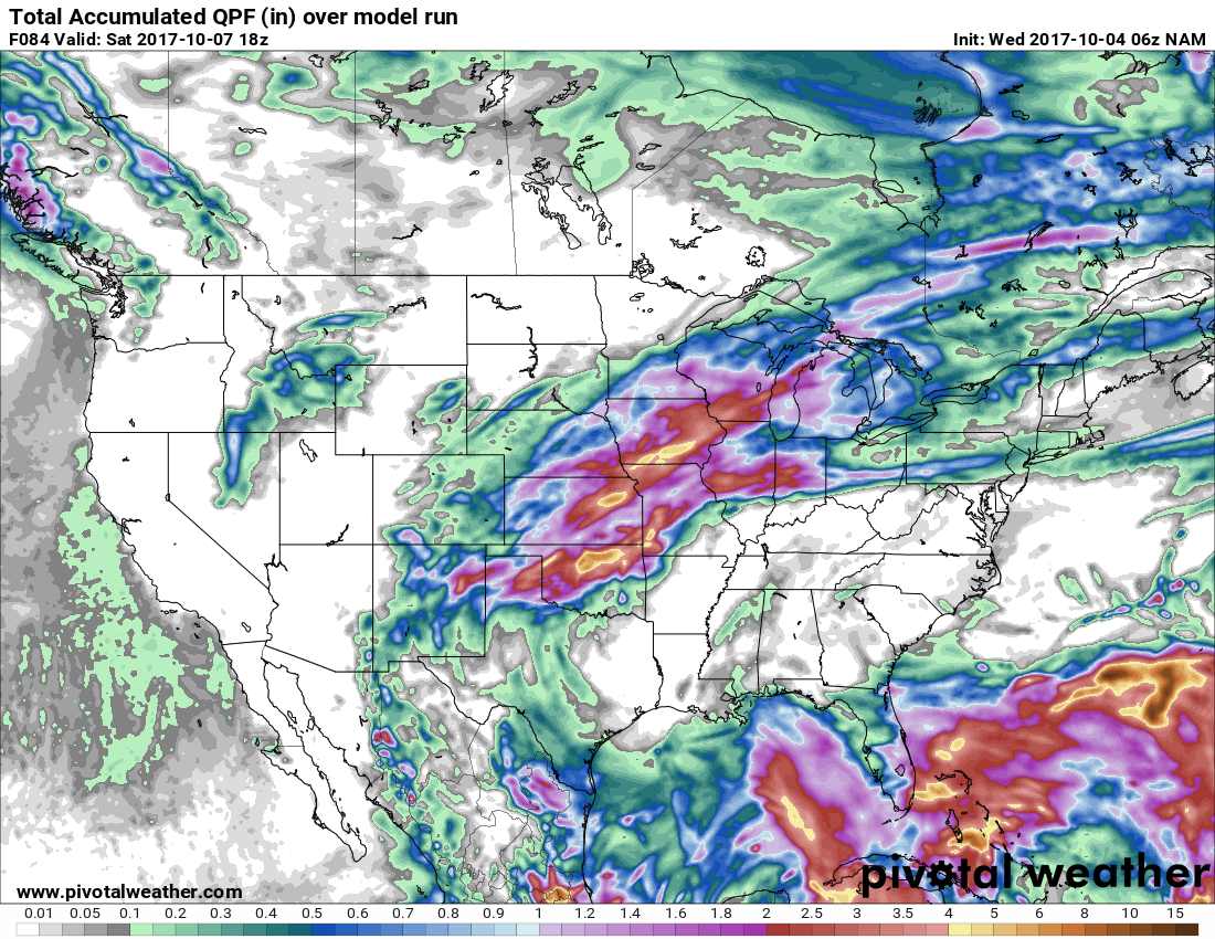
Here is where the NAM tracks the tropical moisture. It brushes our area..
.
The GFS on the other hand is further west. This raises questions.
.
.
The EC guidance has shifted westward, as well. The tropical system can be seen moving ashore in Louisiana and Mississippi.
The colors represent rain and rain intensity. Obviously some heavy rain along the path of Nate.
.
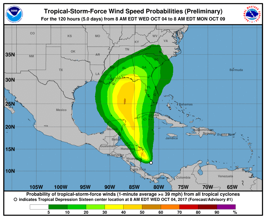
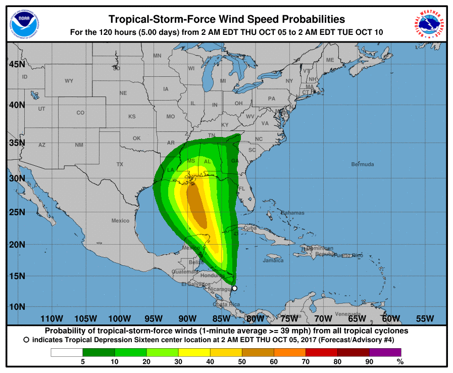
The next big ticket item, in the weather world, is the tropical system in the Gulf of Mexico. This system has been trending westward in the model guidance.
Let me show you two maps.
This was the Wednesday forecast track of the wind field.
This next image is the Thursday forecast track of the wind field.
Notice the shift westward?
Tropical systems are difficult to predict days in advance. The forecast skill has dramatically improved over the last decade, but it is not perfect.
Additional shifts are a possibility. This will need to be monitored.
 \
\The concern, at least for our region, is the possibility of increasing clouds and rain chances for Sunday/Monday.
For now, the greatest chance for impacts would be our southern and eastern counties. That would include the Pennyrile area of western Kentucky.
Any shift in the track will impact our forecast. Thus, monitor updates.
Here is the NAM model rainfall forecast through Saturday at 1 pm. Not much for our local area.
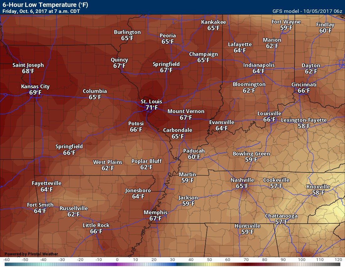
Temperature Forecast
Thursday night low temperatures
Friday high temperatures
No graphics, because the models are too cool with Friday. Thus, I left this graphic off.
Friday night low temperatures
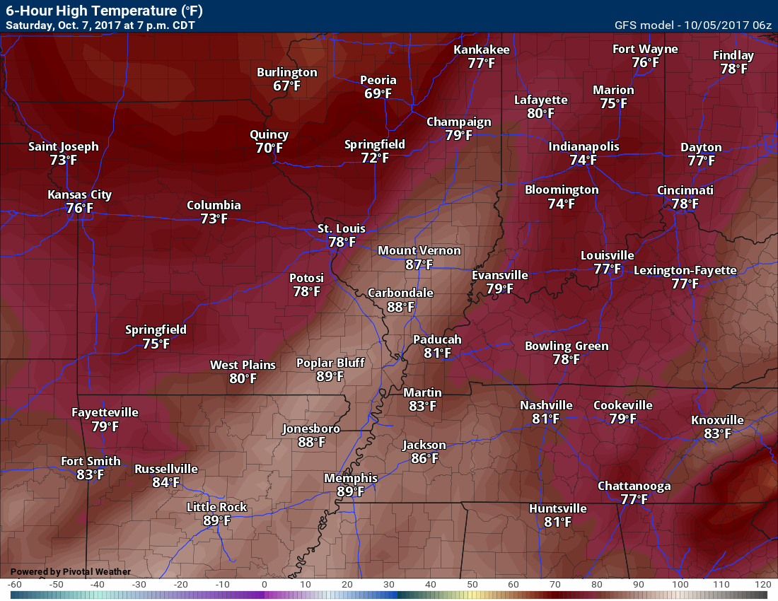
Saturday high temperatures
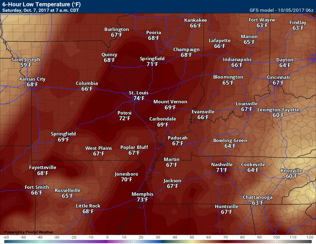
Saturday low temperatures
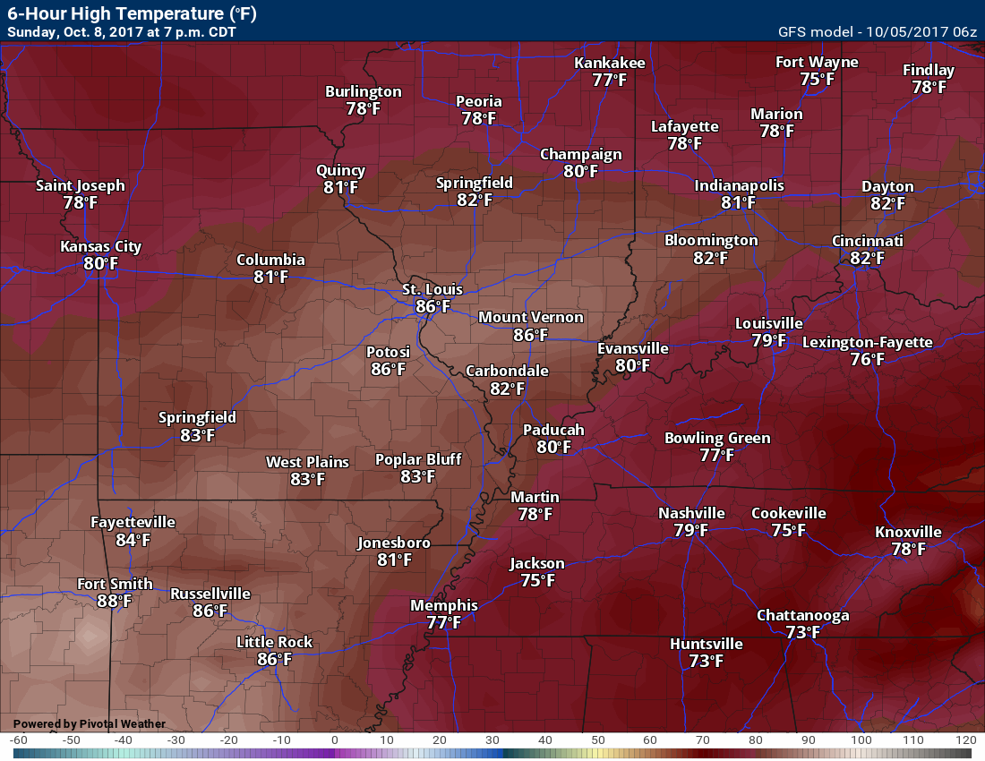
Sunday high temperatures
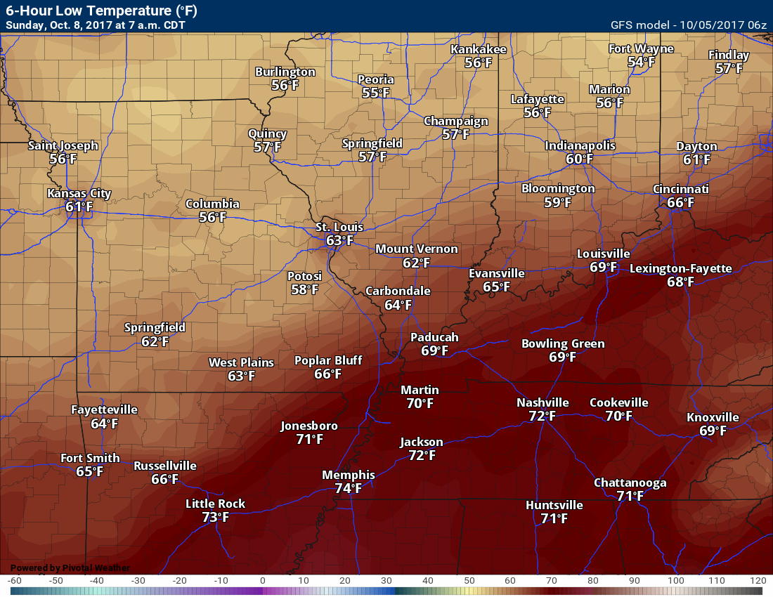
Sunday night low temperatures
These numbers are partially dependent on the track of the tropical system
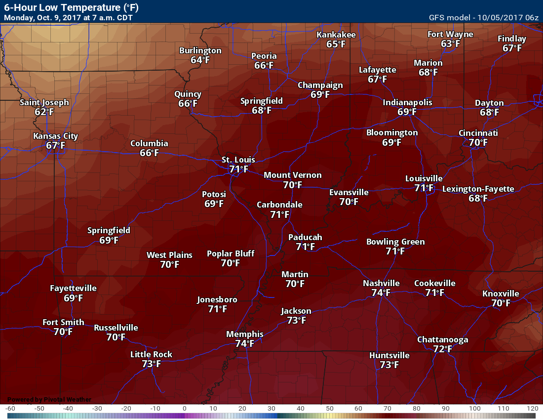
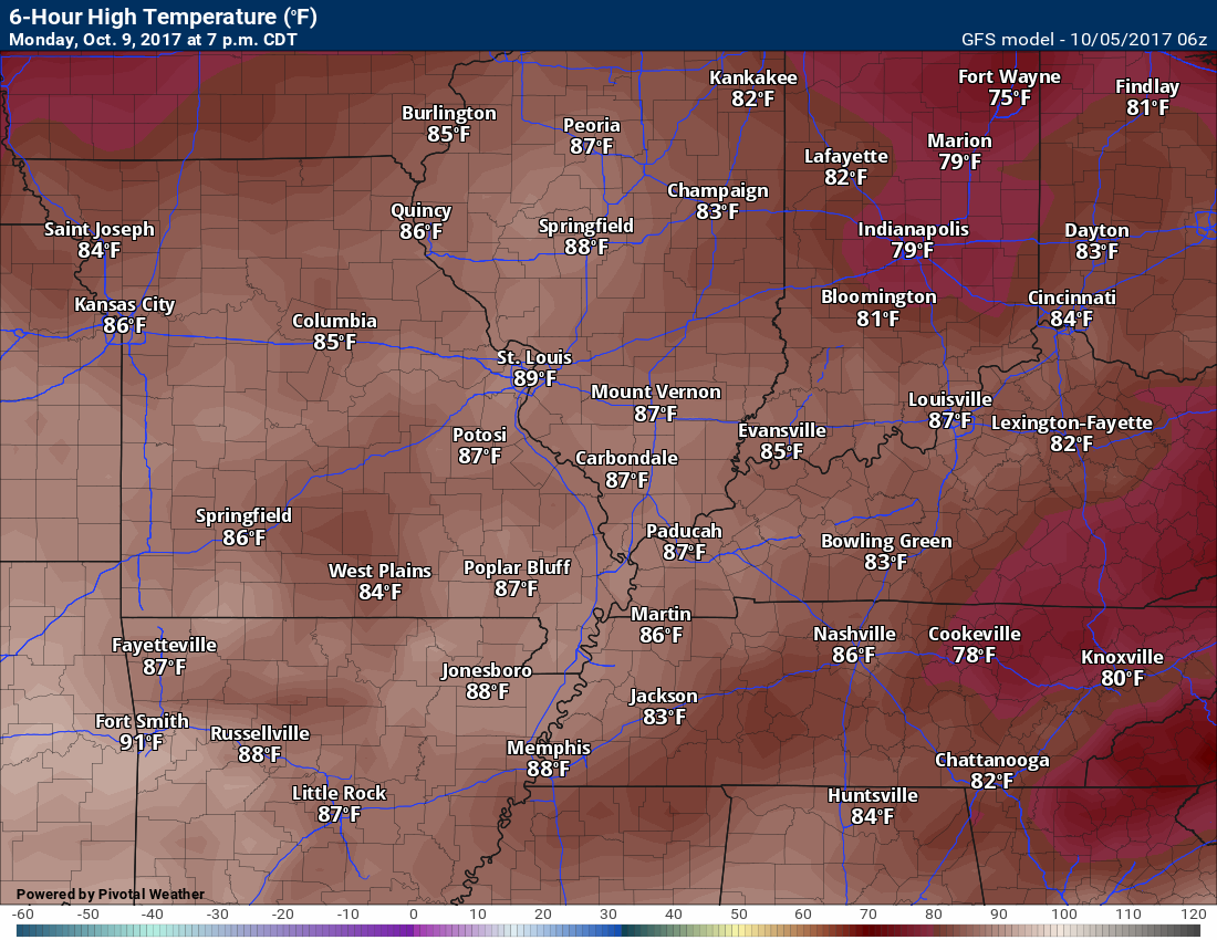
Monday high temperatures
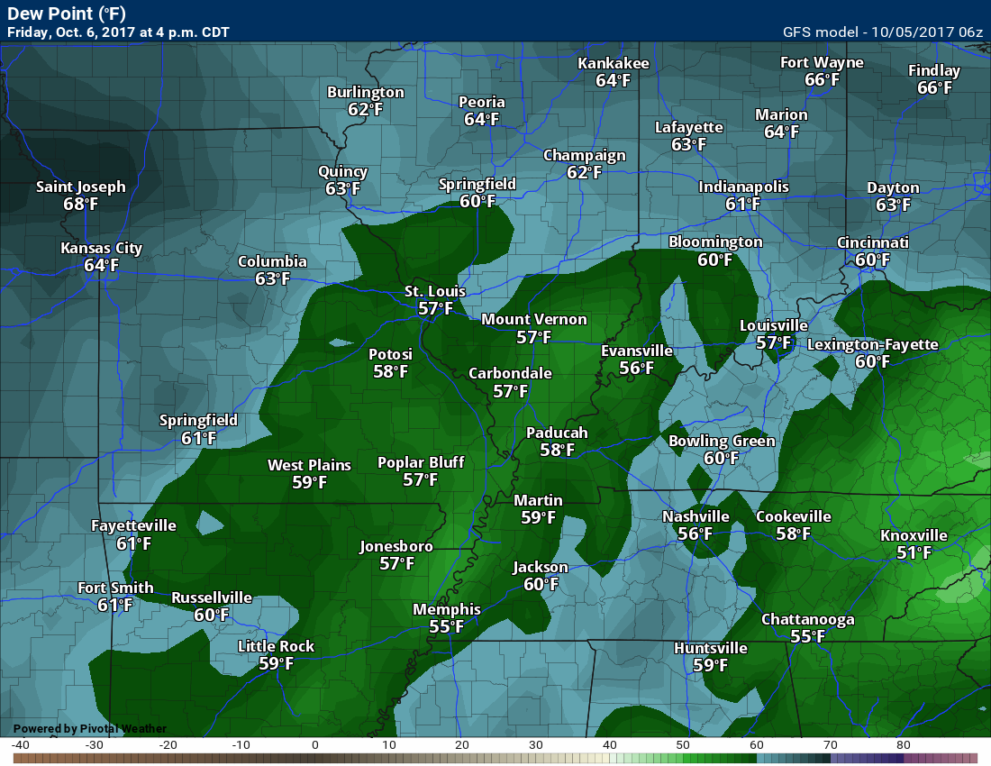
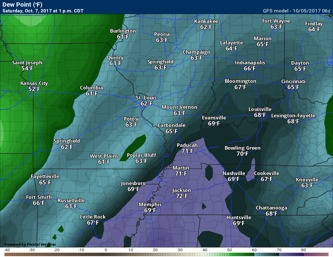
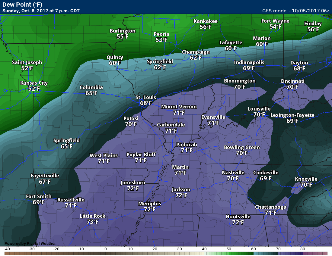
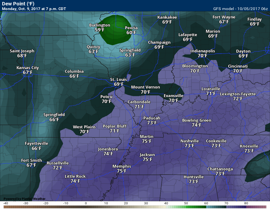
Dew point scale
Dew points are what control how you feel outside.

Friday dew points
Saturday dew points
Sunday dew points
These higher dew points are dependent on the track of the tropical system
Monday dew points
These higher dew points are dependent on the track of the tropical system
Long range forecast discussion
The long range will be dominated by what happens with the tropical system on Sunday/Monday.
This system will influence both temperatures and dew points. If the system impacts our region the dew points will be in the 70’s on Sunday, Monday, and Tuesday. Those numbers represent muggy air.
Another cold front will move through our region Monday night/Tuesday. This front could interact with some of the tropical moisture. That would increase our rain totals.
I don’t have enough confidence to go all in on what happens with the cold front.
The cold front will spark at least some shower and thunderstorm activity on Monday night/Tuesday.
Cooler air is anticipated for the middle/end of next week. How cool is the question.
The tropical system could impact that trough. The trough is a dip in the jet stream. A dip in the jet stream normally means cooler weather in our region.
At one point, the GFS was showing lower 40’s late next week. The GFS has a cold bias, but I do buy into the idea that somewhat cooler air will arrive as we move deeper into next week.
Frost, at this time, appears unlikely.
Are you subscribing to Weather Talk app/text messages and videos? This is what helps support all of the data you see each day.
We now offer premium videos for the short and long range forecasts! These videos are produced by a team of long range forecast experts. They are brought to you as bonus information. Activate text option four in order to receive these on your app or via text.
Subscribe at www.beaudodsonweather.com
We offer an Apple and Android app (scroll to the bottom of this page for more information).

Were you aware that I hired a team of meteorologists for long range videos?
To learn more, click this link
http://cms.weathertalk.com/meet-the-team/
.


We offer regional radars and local city radars – if a radar does not update then try another one. Occasional browsers need their cache cleared. You may also try restarting your browser. This will usually fix any problems.
During the winter you can track snow and ice by clicking the winterize button on the local city view interactive radars.
You may email me at beaudodson@usawx.com
Interactive Weather Radar Page. Choose the city nearest your location: Click this link
National interactive radar: Click this link.
The Beau Dodson Weather APP is ready for Apple and Android users. The app provides a faster way for you to receive my text messages. ATT and Verizon are not always reliable when it comes to speed.
Some of you have asked if you can receive the texts on your phone and the app. The answer to that is, yes. The Android app will automatically allow that to happen. On the Apple app, however, you will need to open your app and click the settings button. Make sure the green tab is OFF. Off means you will still receive the texts to your phone and the app. If you have any questions, then email me at beaudodson@usawx.com
The app is for text subscribers.
The direct download, for the Apple app, can be viewed here
https://itunes.apple.com/us/app/id1190136514
Here is the download link for the Android version Click Here
If you have not signed up for the texting service then you may do so at www.beaudodsonweather.com


——————————————————–
Your support helps with the following:

and

.

Whom do you trust for your weather information?
I have studied weather, in our region, since the late 1970’s. I have 40 years of experience in observing our regions weather patterns. My degree is in Broadcast Meteorology and a Bachelor’s of Science.
My resume includes:
Member of the American Meteorological Society.
NOAA Weather-Ready Nation Ambassador.
Meteorologist for McCracken County Emergency Management. I served from 2005 through 2015.
Meteorologist for McCracken County Rescue. 2015 through current
I own and operate the Southern Illinois Weather Observatory.
I am the chief meteorologist for Weather Talk LLC.
I am also a business owner in western Kentucky.
Recipient of the Mark Trail Award, WPSD Six Who Make A Difference Award, Kentucky Colonel, and the Caesar J. Fiamma” Award from the American Red Cross.
In 2005, I helped open the largest American Cross shelter in U.S. history. This was in Houston, Texas. I was deployed to help with the aftermath of Hurricane Katrina and Hurricane Rita. I was a shelter manager of one of the Houston, Texas shelter divisions.
In 2009 I was presented with the Kentucky Office of Highway Safety Award.
Recognized by the Kentucky House of Representatives for my service to the State of Kentucky leading up to several winter storms and severe weather outbreaks.
If you click on the image below you can read the Kentucky House of Representatives Resolution.

I am President of the Shadow Angel Foundation which serves portions of western Kentucky and southern Illinois.
There is a lot of noise on the internet. A lot of weather maps are posted without explanation. You need a trusted source for information.
My forecast philosophy is simple and straight forward.
- Communicate in simple terms
- To be as accurate as possible within a reasonable time frame before an event
- Interact with you on Twitter, Facebook, email, texts, and this blog
- Minimize the “hype” that you might see through other weather sources
- Push you towards utilizing wall-to-wall LOCAL TV coverage during severe weather events

Sign up for my AWARE email by clicking here.
I typically send AWARE emails before severe weather, winter storms, or other active weather situations. I do not email watches or warnings. The emails are a basic “heads up” concerning incoming weather conditions