WeatherTalk monthly operating costs can top $2000.00. Your $5 subscription helps pay for those costs. I work for you.
The $5 will allow you to register up to seven phones!
For $5 a month you can receive the following. You may choose to receive these via your WeatherTalk app or regular text messaging.
Severe weather app/text alerts from my keyboard to your app/cell phone. These are hand typed messages from me to you. During tornado outbreaks, you will receive numerous app/text messages telling you exactly where the tornado is located.
- Daily forecast app/texts from my computer to your app/cell phone.
- Social media links sent directly to your app/cell phone. When I update the blog, videos, or Facebook you will receive the link.
- AWARE emails. These emails keep you well ahead of the storm. They give you several days of lead time before significant weather events.
- Direct access to Beau via text and email. Your very own personal meteorologist. I work for you!
- Missouri and Ohio Valley centered video updates
- Long-range weather videos
- Week one, two, three and four temperature and precipitation outlooks.
Monthly outlooks. - Your subscription also will help support several local charities.
Would you like to subscribe? Subscribe at www.beaudodsonweather.com

I encourage subscribers to use the app vs regular text messaging. We have found text messaging to be delayed during severe weather. The app typically will receive the messages instantly. I recommend people have three to four methods of receiving their severe weather information.
Remember, my app and text alerts are hand typed and not computer generated. You are being given my personal attention during significant weather events.

WWW.WEATHERTALK.COM subscribers, here is my day to day schedule for your weather products.
These are bonus videos and maps for subscribers. I bring these to you from the BAMwx team. I pay them to help with videos.
The Ohio and Missouri Valley videos cover most of our area. They do not have a specific Tennessee Valley forecast but may add one in the future.
The long-range video is technical. Over time, you can learn a lot about meteorology from the long range video. Just keep in mind, it is a bit more technical.


October 03, 2018
Wednesday Forecast Details
Forecast: Partly to mostly sunny. Hot. Humid. Near record high temperatures. Summer-like. Breezy, at times.
Temperatures: MO ~ 86 to 90 IL ~ 86 to 90 KY ~ 86 to 90 TN ~ 86 to 90
What is the chance of precipitation? MO ~ 10% IL ~ 10% KY ~ 5% TN ~ 5%
Coverage of precipitation: Most likely none
Wind: South and southwest at 8 to 16 mph with higher gusts. Strongest winds over southeast Missouri and southern Illinois.
What impacts are anticipated from the weather? Most likely none.
My confidence in the forecast verifying: High
Is severe weather expected? No
The NWS defines severe weather as 58 mph wind or great, 1″ hail or larger, and/or tornadoes
Should I cancel my outdoor plans? No
UV Index: 8 to 10 High
Sunrise: 6:53 AM
Wednesday Night Forecast Details:
Forecast: A few clouds. Warm and humid. Near record high low temperatures. Increasing clouds late. A chance of showers and thunderstorms over our northern counties after midnight. That would include areas from Perry County, MO north and northeast towards Jefferson County, IL. Lesser chances as you travel south of that line.
Temperatures: MO ~ 70 to 74 IL ~ 70 to 74 KY ~ 70 to 74 TN ~ 70 to 74
What is the chance of precipitation? MO ~ 40% to 50% north and 10% as you move into the Bootheel of Missouri IL ~ 40% to 50% northern counties (more towards Randolph County towards Jefferson County tapering to less than 20% near the Ohio River KY ~ 20% TN ~ 20%
Coverage of precipitation: Scattered
Wind: South and southwest at 8 to 16 mph with gusts above 20 mph. Again, strongest winds will be over southeast Missouri and southern Illinois.
What impacts are anticipated from the weather? Wet roadways and lightning over our northern counties.
My confidence in the forecast verifying: Medium
Is severe weather expected? No
The NWS defines severe weather as 58 mph wind or great, 1″ hail or larger, and/or tornadoes
Should I cancel my outdoor plans? No
Sunset: 6:36 PM
Moonrise: 12:30 AM Waning Crescent
Moonset: 3:15 PM
October 04, 2018
Thursday Forecast Details
Forecast: Medium confidence in the placement of a frontal boundary. The placement will result in precipitation chances along and near it. Any shift north or south would cause changes in the rain probabilities. Keep that in mind. Increasing clouds. Warm. Humid. A good chance of showers and thunderstorms over the northern half of the region. Heavy rain possible with storms form. Greatest coverage will likely be along and north of a line from Bollinger County, MO into Cape Girardeau County, MO into Union, Johnson, and Pope Counties in southern Illinois and north-northeast from there towards Marion, KY and Madison, KY. Along and north of that line will stand the best chance of seeing some showers and thunderstorms. South of that line will have a chance of scattered showers and thunderstorms. There remain some questions about how far south the boundary will push. Check radars if you have outdoor events.
Temperatures: MO ~ 70 to 75 Farmington to Mt Vernon and then 84 to 88 as you move further south. Warmer as you move further away from the frontal boundary IL ~ 70 to 75 along and north of a line from Farmington, Missouri to Mt Vernon, Illinois. 83 to 86 as you move further south towards Marion, Illinois, and then towards the Ohio River. This will be because of clouds and precipitation. KY ~ 86 to 88 TN ~ 86 to 90
What is the chance of precipitation? MO ~ 60% (mainly north of a line from Cape Girardeau County, MO towards Pope County, IL) IL ~ 60% except southern seven counties. The rain chances there will be 30% to 40% KY ~ 30% over most of western Kentucky. Chances will be higher as you move towards Henderson and Owensboro, Kentucky. TN ~ 30%
Coverage of precipitation: Scattered to perhaps numerous over our northern counties. Scattered elsewhere. Tapering to isolated as you move into the Missouri Bootheel and northwest Tennessee.
Wind: South and southwest at 6 to 12 mph with higher gusts likely
What impacts are anticipated from the weather? Wet roadways. Lightning. Locally heavy rain.
My confidence in the forecast verifying: Medium
Is severe weather expected? No
The NWS defines severe weather as 58 mph wind or great, 1″ hail or larger, and/or tornadoes
Should I cancel my outdoor plans? No
UV Index: 6 High
Sunrise: 6:53 AM
Thursday Night Forecast Details:
Forecast: Partly cloudy. Mild. A few showers or thunderstorms possible (mainly across our northern counties). Greatest chance along I64 with increasing chances north of there.
Temperatures: MO ~ 64 to 68 IL ~ 64 to 68 KY ~ 68 to 70 TN ~ 68 to 70
What is the chance of precipitation? MO ~ 30% to 40% northern counties decreasing to 10% over the Bootheel IL ~ 40% near the I64 corridor diminishing to 20% near the Ohio River KY ~ 20% TN ~ 20%
Coverage of precipitation: Scattered near I64 decreasing to none to isolated over the Bootheel into west KY/west TN
Wind: South at 6 to 12 mph
What impacts are anticipated from the weather? Spotty wet roadways and lightning
My confidence in the forecast verifying: Medium
Is severe weather expected? No
The NWS defines severe weather as 58 mph wind or great, 1″ hail or larger, and/or tornadoes
Should I cancel my outdoor plans? No, but check radars
Sunset: 6:34 PM
Moonrise: 1:35 AM Waning Crescent
Moonset: 4:04 PM
October 05, 2018
Friday Forecast Details
Forecast: Mostly sunny. Hot and humid. Near record high temperatures. A few afternoon clouds.
Temperatures: MO ~ 85 to 90 IL ~ 85 to 90 KY ~ 85 to 90 TN ~85 to 90
What is the chance of precipitation? MO ~ 10% IL ~ 20% KY ~ 10% TN ~ 10%
Coverage of precipitation: Most likely none. An isolated shower or storm over northern/northeastern portions of southern Illinois.
Wind: South at 8 to 16 mph with higher gusts possible, especially over southeast Missouri and southern Illinois.
What impacts are anticipated from the weather? None to perhaps isolated wet roads and lightning over the northern portions of southern Illinois
My confidence in the forecast verifying: Medium
Is severe weather expected? No
The NWS defines severe weather as 58 mph wind or great, 1″ hail or larger, and/or tornadoes
Should I cancel my outdoor plans? No
UV Index: 8 High
Sunrise: 6:54 AM
Friday Night Forecast Details:
Forecast: Partly cloudy. Warm with near record high low temperatures. Most of the area should remain dry. A few spotty showers or thunderstorms are possible over our western counties in southeast Missouri. Better chances as you near Poplar Bluff vs Cape Girardeau. Many areas should remain dry.
Temperatures: MO ~ 68 to 72 IL ~ 68 to 74 KY ~ 68 to 74 TN ~ 68 to 74
What is the chance of precipitation? MO ~ 20% IL ~ 20% KY ~ 10% TN ~ 10%
Coverage of precipitation: None to isolated. Isolated would most likely be over southeast Missouri and southern Illinois.
Wind: South at 7 to 14 mph and gusty
What impacts are anticipated from the weather? A few wet roadways and lightning. Again, mainly over southeast Missouri and southern Illinois. The further north and west you travel the greater the chance of a few showers and storms.
My confidence in the forecast verifying: Low to medium
Is severe weather expected? No
The NWS defines severe weather as 58 mph wind or great, 1″ hail or larger, and/or tornadoes
Should I cancel my outdoor plans? No, but check the radars
Sunset: 6:33 PM
Moonrise: 4:48 PM Waning Crescent
Moonset: 2:43 AM
LOW CONFIDENCE ON THE WEEKEND FORECAST
MONITOR UPDATES
RAIN CHANCES MAY NEED ADJUSTING.
October 06, 2018
Saturday Forecast Details
Forecast: Partly sunny. Warm and humid. A chance of a shower or thunderstorm, especially western and northern counties from Poplar Bluff, Missouri, towards Mt Vernon, Illinois.
Temperatures: MO ~84 to 88 IL ~ 84 to 88 KY ~ 84 to 88 TN ~ 84 to 88 If we have more clouds, then temperatures will be a few degrees cooler.
What is the chance of precipitation? MO ~ 40% IL ~ 30% KY ~ 20% TN ~ 20%
Coverage of precipitation: Widely scattered
Wind: South at 7 to 14 mph with gusts to 18 mph
What impacts are anticipated from the weather? Wet roadways. Lightning. Greater chances over southeast Missouri and southern Illinois. Most of the area may remain dry if the front doesn’t push its way into the area.
My confidence in the forecast verifying: LOW
Is severe weather expected? No
The NWS defines severe weather as 58 mph wind or great, 1″ hail or larger, and/or tornadoes
Should I cancel my outdoor plans? I would monitor updates and radars. There could be some precipitation. This would mainly be over southeast Missouri and southwest and northern portions of southern Illinois. Lesser chances elsewhere.
UV Index: 6 High
Sunrise: 6:55 AM
Saturday Night Forecast Details:
Forecast: Partly cloudy. A shower or thunderstorm possible. Especially western and northern counties from Poplar Bluff, Missouri, towards Mt Vernon, Illinois.
Temperatures: MO ~ 64 to 66 IL ~ 64 to 66 KY ~ 64 to 68 TN ~ 64 to 68
What is the chance of precipitation? MO ~ 40% IL ~ 30% to 40% KY ~ 20% TN ~ 20%
Coverage of precipitation: Widely scattered
Wind: South and southeast at 5 to 10 mph with gusts to 14 mph
What impacts are anticipated from the weather? Wet roadways. Lightning possible.
My confidence in the forecast verifying: LOW
Is severe weather expected? No
The NWS defines severe weather as 58 mph wind or great, 1″ hail or larger, and/or tornadoes
Should I cancel my outdoor plans? Monitor updates.
Sunset: 6:31 PM
Moonrise: 3:53 AM Waning Crescent
Moonset: 5:27 PM
October 07, 2018
Sunday Forecast Details
Forecast: Partly sunny. Warm. A scattered shower or thunderstorm possible. Clouds will help determine high temperatures. Fewer clouds and we will be warmer.
Temperatures: MO ~ 82 to 86 IL ~ 82 to 86 KY ~ 83 to 86 TN ~ 83 to 86
What is the chance of precipitation? MO ~ 30% IL ~ 30% KY ~ 30% TN ~ 30%
Coverage of precipitation: Scattered
Wind: South and southeast winds at 7 to 14 mph with gusts to 20 mph
What impacts are anticipated from the weather? A few wet roadways possible. Lightning.
My confidence in the forecast verifying: LOW
Is severe weather expected? Unlikely
The NWS defines severe weather as 58 mph wind or great, 1″ hail or larger, and/or tornadoes
Should I cancel my outdoor plans? No, but monitor updates
UV Index: 6 to 8 High
Sunrise: 6:56 AM
Sunday Night Forecast Details:
Forecast: Partly cloudy. A slight chance of showers and thunderstorms.
Temperatures: MO ~ 62 to 66 IL ~ 62 to 66 KY ~ 64 to 68 TN ~ 64 to 68
What is the chance of precipitation? MO ~ 20% IL ~ 20% KY ~ 20% TN ~ 20%
Coverage of precipitation: Scattered
Wind: Southeast at 6 to 12 mph
What impacts are anticipated from the weather? Some patchy fog could lower visibility. Isolated showers would mean wet roadways and possibly some lightning.
My confidence in the forecast verifying: LOW
Is severe weather expected? Unlikely
The NWS defines severe weather as 58 mph wind or great, 1″ hail or larger, and/or tornadoes
Should I cancel my outdoor plans? Monitor updates
Sunset: 6:30 PM
Moonrise: 5:03 AM Waning Crescent
Moonset: 6:04 PM
October 08, 2018
Monday forecast: Partly cloudy. Warm. A slight chance of thunderstorms.
Temperatures: MO ~ 83 to 86 IL ~ 83 to 86 KY ~ 83 to 86 TN ~ 83 to 86
What is the chance of precipitation? MO ~ 20% IL ~ 20% KY ~ 20% TN ~ 20%
Coverage of precipitation: Isolated
Wind: South and southeast at 6 to 12 mph
What impacts are anticipated from the weather? Isolated wet roadways and lightning.
My confidence in the forecast verifying: LOW
Is severe weather expected? Unlikely
The NWS defines severe weather as 58 mph wind or great, 1″ hail or larger, and/or tornadoes
Should I cancel my outdoor plans? Monitor updates
UV Index: 6 High
Sunrise: 6:57 AM
Monday Night Forecast Details:
Forecast: Partly cloudy. An isolated shower or thunderstorm.
Temperatures: MO ~ 63 to 66 IL ~ 63 to 66 KY ~ 63 to 66 TN ~ 63 to 66
What is the chance of precipitation? MO ~ 20% IL ~ 20% KY ~ 20% TN ~ 20%
Coverage of precipitation: Isolated
Wind: Southeast winds at 6 to 12 mph
What impacts are anticipated from the weather? Wet roadways. Lightning.
My confidence in the forecast verifying: LOW
Is severe weather expected? No
The NWS defines severe weather as 58 mph wind or great, 1″ hail or larger, and/or tornadoes
Should I cancel my outdoor plans? Monitor updates
Sunset: 6:28 PM
Moonrise: 6:12 AM Waning Crescent
Moonset: 6:38 PM
Learn more about the UV index readings. Click here.

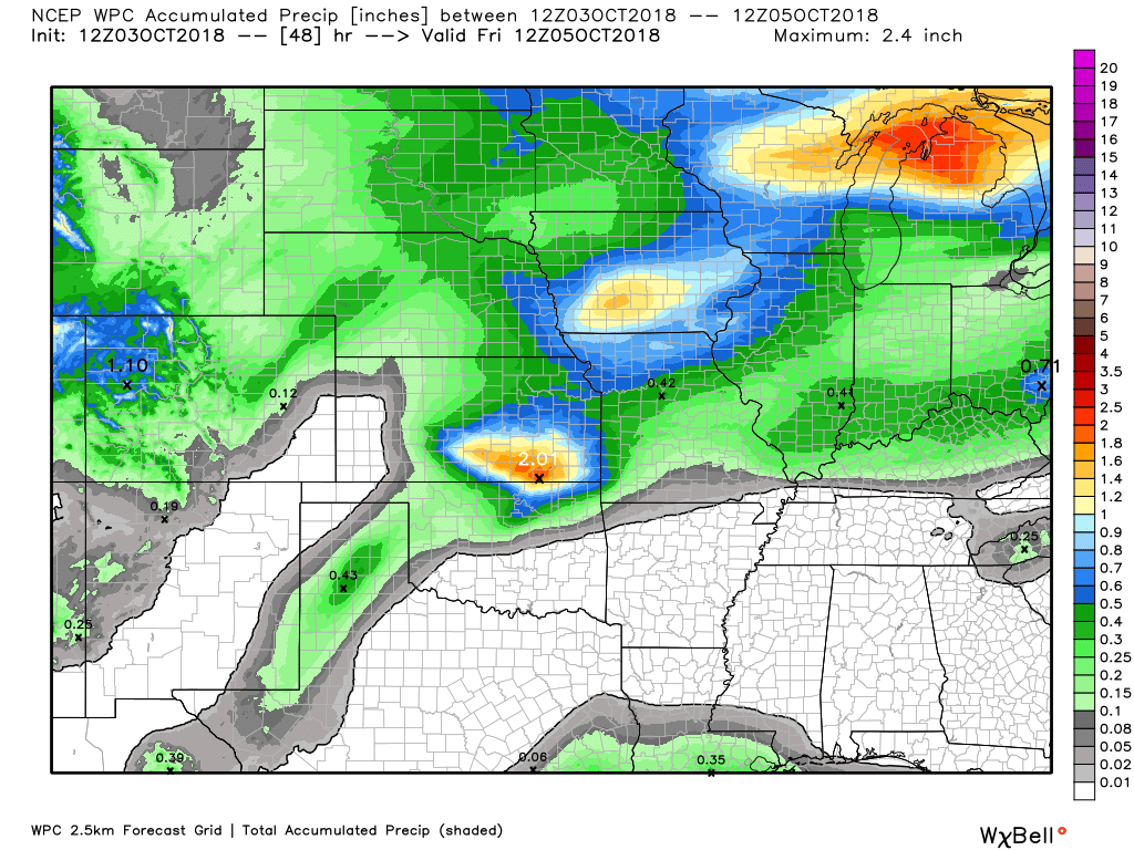
Here is the latest WPC/NOAA rainfall outlook.
This first image is the 48-hour rainfall totals. This will capture the Thursday/Thursday night activity. Portions of the region may receive no measurable rain.
Greatest chances of measurable rain will be over southeast Missouri and southern Illinois and then into northwest Kentucky towards Owensboro. Chances decrease the further south you travel.
Click images to enlarge them.
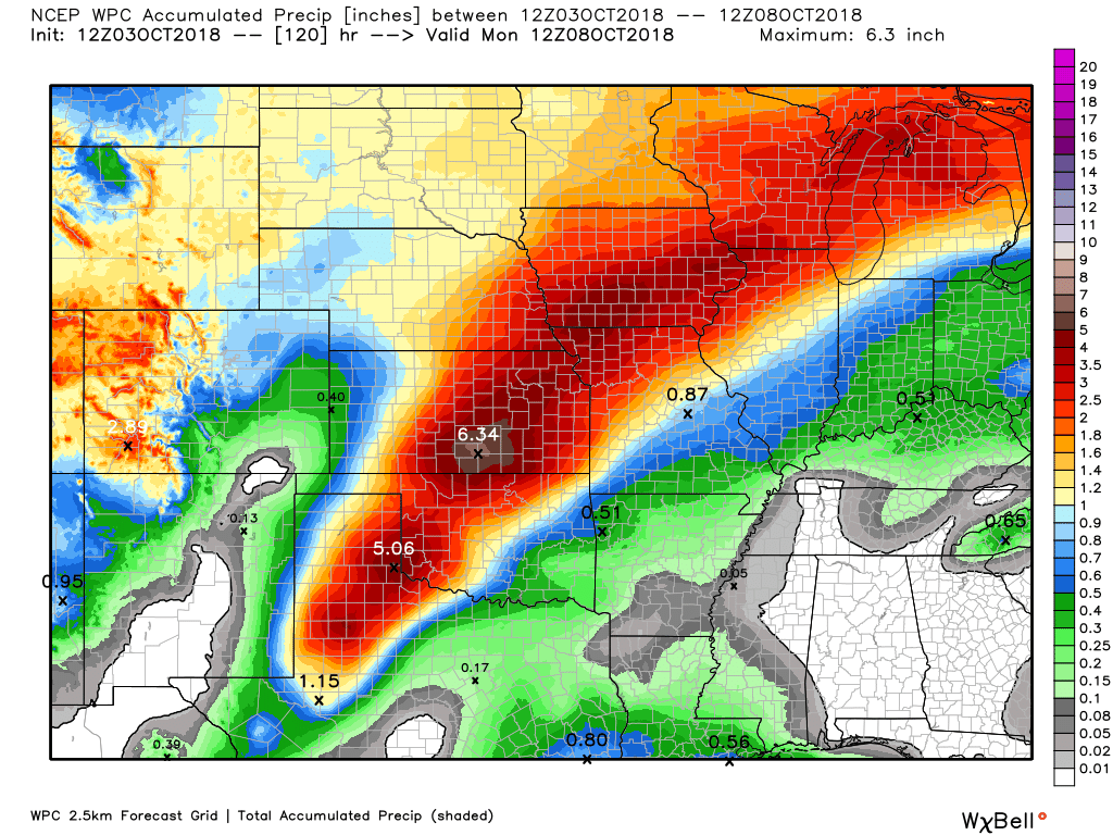
This next graphic will take us into next Monday morning.
Click to enlarge
Very heavy rain across portions of Texas into Wisconsin. That will occur along the stalled frontal boundary. Tropical moisture is partly responsible for the high totals.
You can see that the totals decrease as you move into our local area.
I am always looking for feedback.

I will keep an eye on rain chances this weekend. I would not change any plans, yet. I would monitor update. A few showers and storms are possible.
Did you know that you can find me on Twitter?

Need a forecast for an outdoor event?


We offer interactive local city live radars and regional radars.
If a radar does not update then try another one. If a radar does not appear to be refreshing then hit Ctrl F5 on your keyboard.
You may also try restarting your browser. The local city view radars also have clickable warnings.
During the winter months, you can track snow and ice by clicking the winterize button on the local city view interactive radars.

Questions? Broken links? Other questions?
You may email me at beaudodson@usawx.com

The National Weather Service defines a severe thunderstorm as one that produces quarter size hail or larger, 58 mph winds or greater, and/or a tornado.
Today through Monday: Severe weather is not anticipated. A few thunderstorms will be possible Thursday and Thursday night. The greatest risk of storms will be over southeast Missouri and southern Illinois.
Chances decrease the further south you travel. Lightning is the main concern.
I will be monitoring isolated to widely scattered thunderstorm chances into Monday. Signals for organized thunderstorm activity are low. Monitor updates. Model guidance is not handling this pattern all that well. Adjustments in thunderstorm chances are possible. Severe weather appears unlikely.
Interactive live weather radar page. Choose the city nearest your location. If one of the cities does not work then try a nearby one. Click here.
National map of weather watches and warnings. Click here.
Storm Prediction Center. Click here.
Weather Prediction Center. Click here.

Live lightning data: Click here.

Interactive GOES R satellite. Track clouds. Click here.

Here are the latest local river stage forecast numbers Click Here.
Here are the latest lake stage forecast numbers for Kentucky Lake and Lake Barkley Click Here.

- Hot and humid weather.
- Monitoring thunderstorm chances Thursday and Thursday night.
- Monitoring the weekend forecast.
- Above normal temperatures into next week.
Let me give you the highlights of the weather over the coming days. Hot and humid. It won’t feel like fall. It will feel like summer. That about sums it up.
The wildcards in the forecast continue to be the placement of a cold front that is positioned to our west and north. This front will attempt to push southward Thursday and Thursday night. It will bring a chance of showers and thunderstorms to the region. At this time, it appears the highest rain probabilities will be centered across the northern half of southeast Missouri and the northern half of southern Illinois.
That would include areas from Bollinger County, Missouri eastward into Pope County, Illinois, and then towards Madisonville and Owensboro, Kentucky. The further north you travel the greater the chance of rain. Severe weather is not anticipated. Lightning is the main concern.
If you have outdoor plans Thursday, then monitor updates and radars. A few areas of precipitation are likely.
As you move towards and south of the Ohio River the rain chances will taper. Least coverage should be over the Missouri Bootheel and northwest Tennessee. Some areas will receive no measurable rain.
Let’s look at a few models.
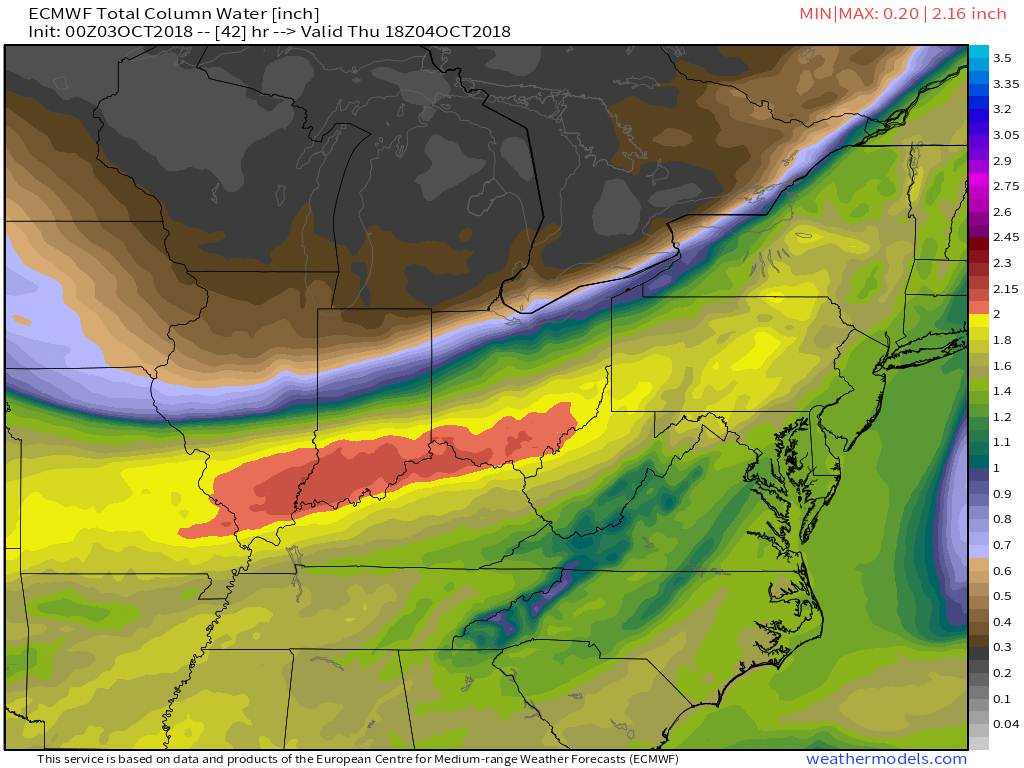
This first image is the PWAT values map. I wanted to show you this because it indicates high PWAT values Thursday and Thursday night over portions of the region.
Red is the higher PWAT. This could mean the models are underplaying rain totals. Any thunderstorms that tap into these PWAT values would produce locally heavy rain. Again, best chance of this would be the northern half of the region.
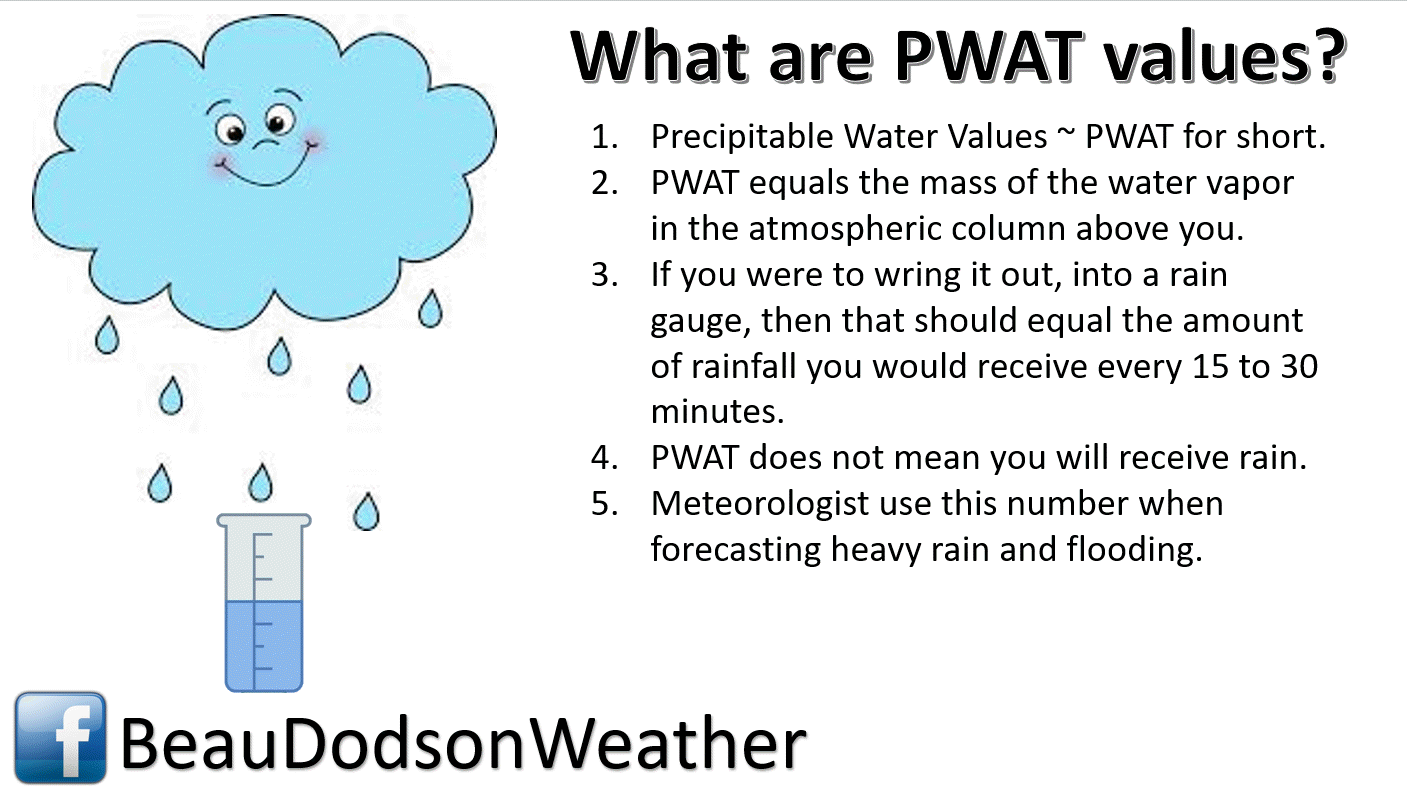
Forecasted PWAT values. See the stripe of red? That represents high PWAT values (topping 1.8″)
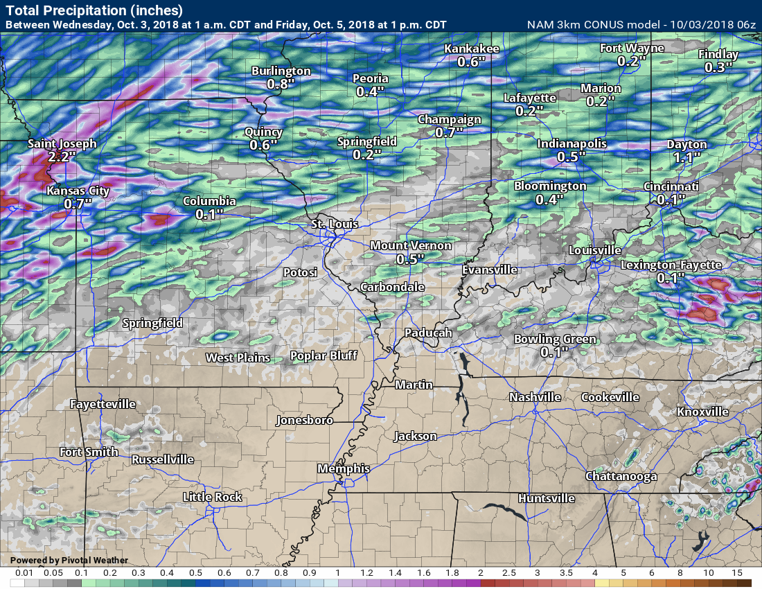
Here is the high-resolution NAM guidance. This covers the rain chances through Friday at 1 PM. Most of this would fall Thursday and Thursday night.
Notice many areas remain dry. A few areas would receive 0.25″ to 0.40″ of rain.
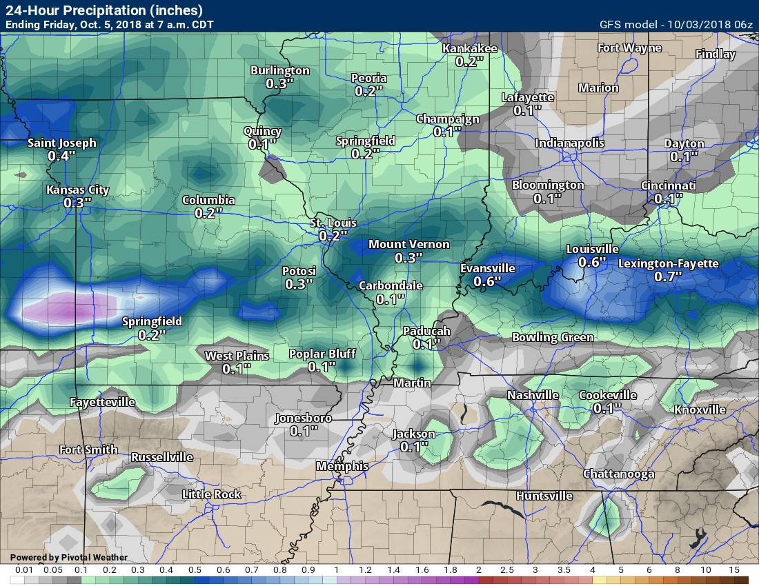
This next image is the GFS model guidance. It is a tad more aggressive with the Thursday system and places it further south. The end result would be increasing rain chances area-wide.
The GFS tends to overdo precipitation totals. Even it has the greatest rain coverage and totals over the northern half of southeast Missouri and northern half of southern Illinois.
The EC model guidance indicates the higher rain totals would be over the northern half of the region, as well.
Again, this is the Thursday and Thursday night rain event.
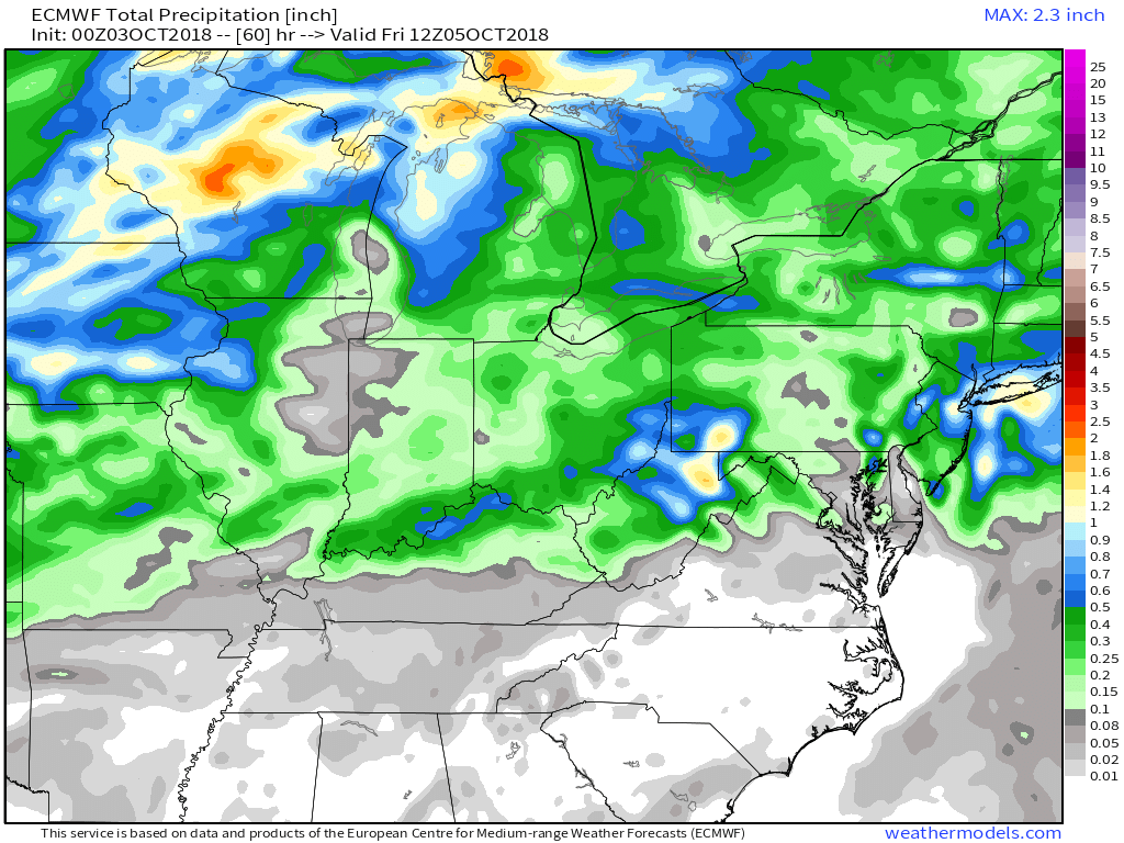
You get a general idea from the above. Some showers and thunderstorms are likely Thursday and Thursday night. The greatest coverage would be over the northern half of the region.
The front will not make it very far south. It will return northward as a warm front Thursday night and Friday. This will keep us in southwest flow aloft. That means warm weather. Humid weather.
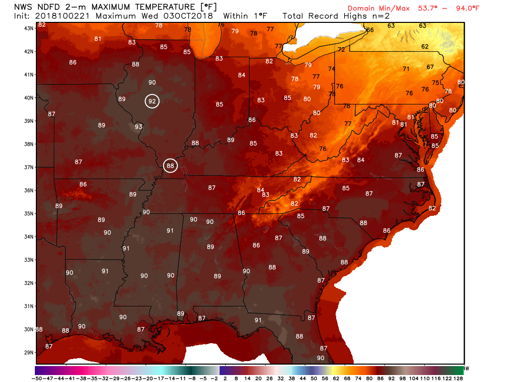
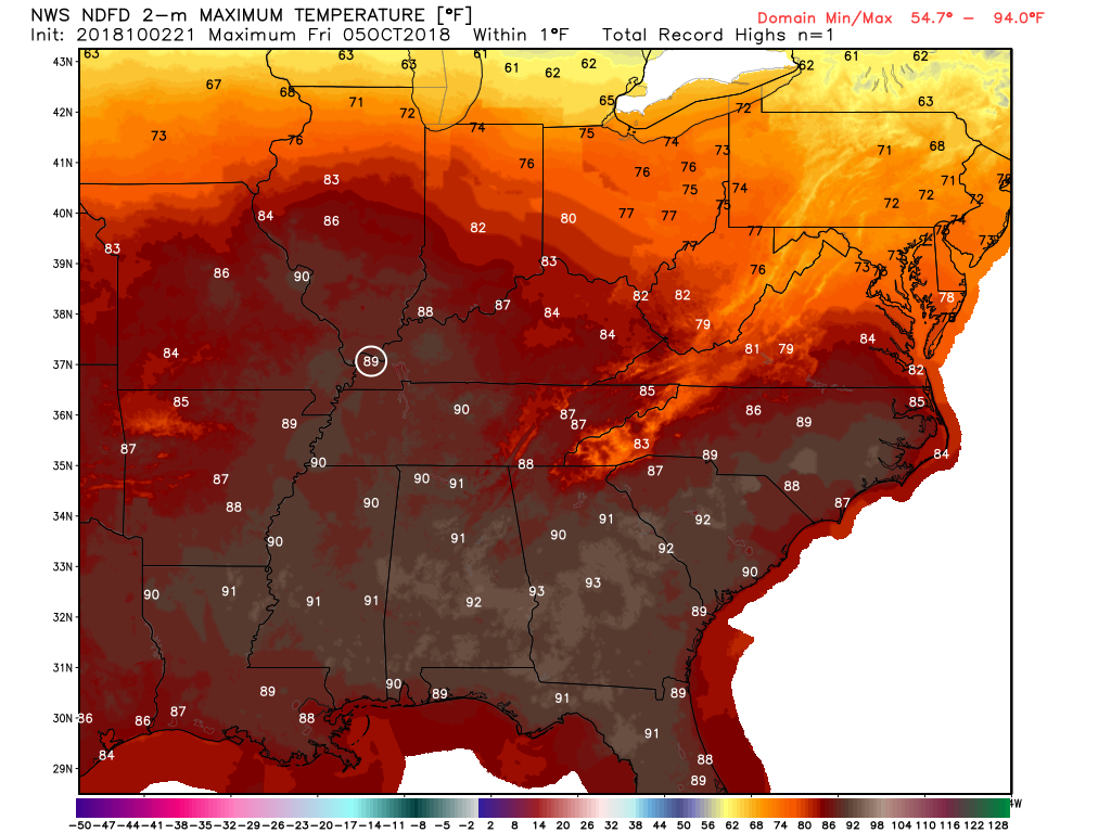
I can’t rule out some record high temperatures over the coming days.
Here are some stats from the Paducah, Kentucky, National Weather Service Office.
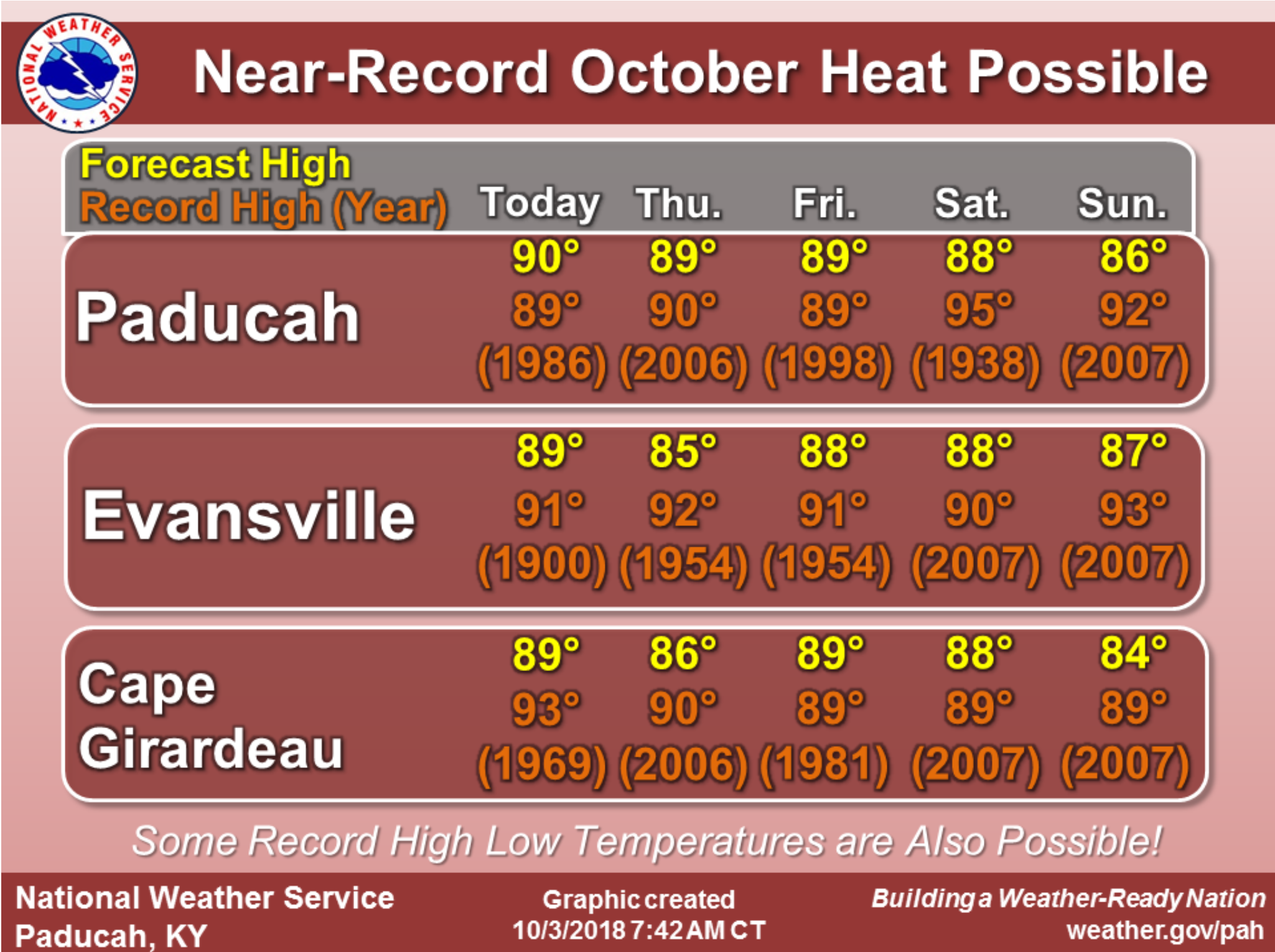
The record high temperature in Paducah, Kentucky, today may be broken. If we hit the 88 degree mark, then it will be a record high.
Click images to enlarge.
The white circled areas are where record high temperatures are forecast to occur. They could occur elsewhere, as well.
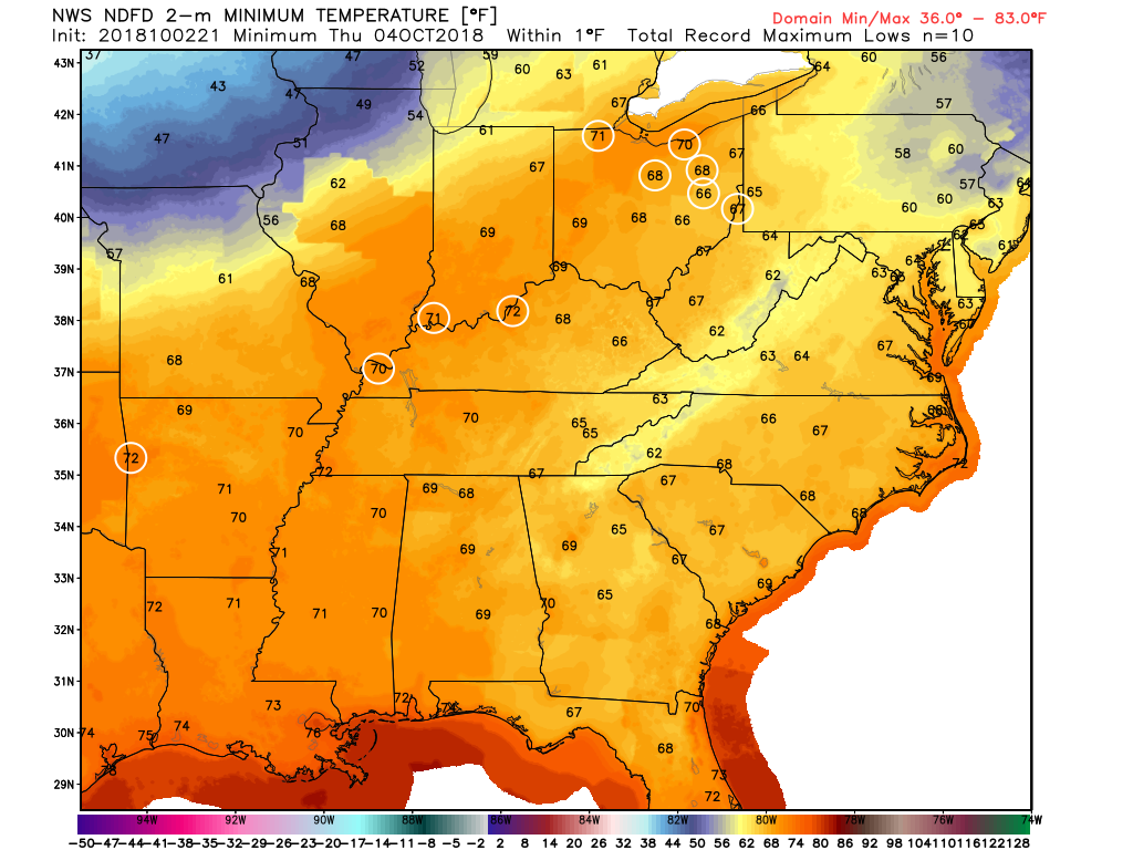
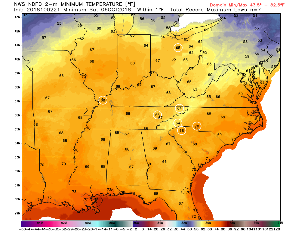
Record high low temperatures are also possible. That would be a record warm minimum.
This map is for Wednesday night/Thursday morning. Again, the white circles are where records may fall.
This next image is showing Friday’s high temperatures. Again, records may fall.
This next image is showing Saturday morning low temperatures. Again, records may fall.
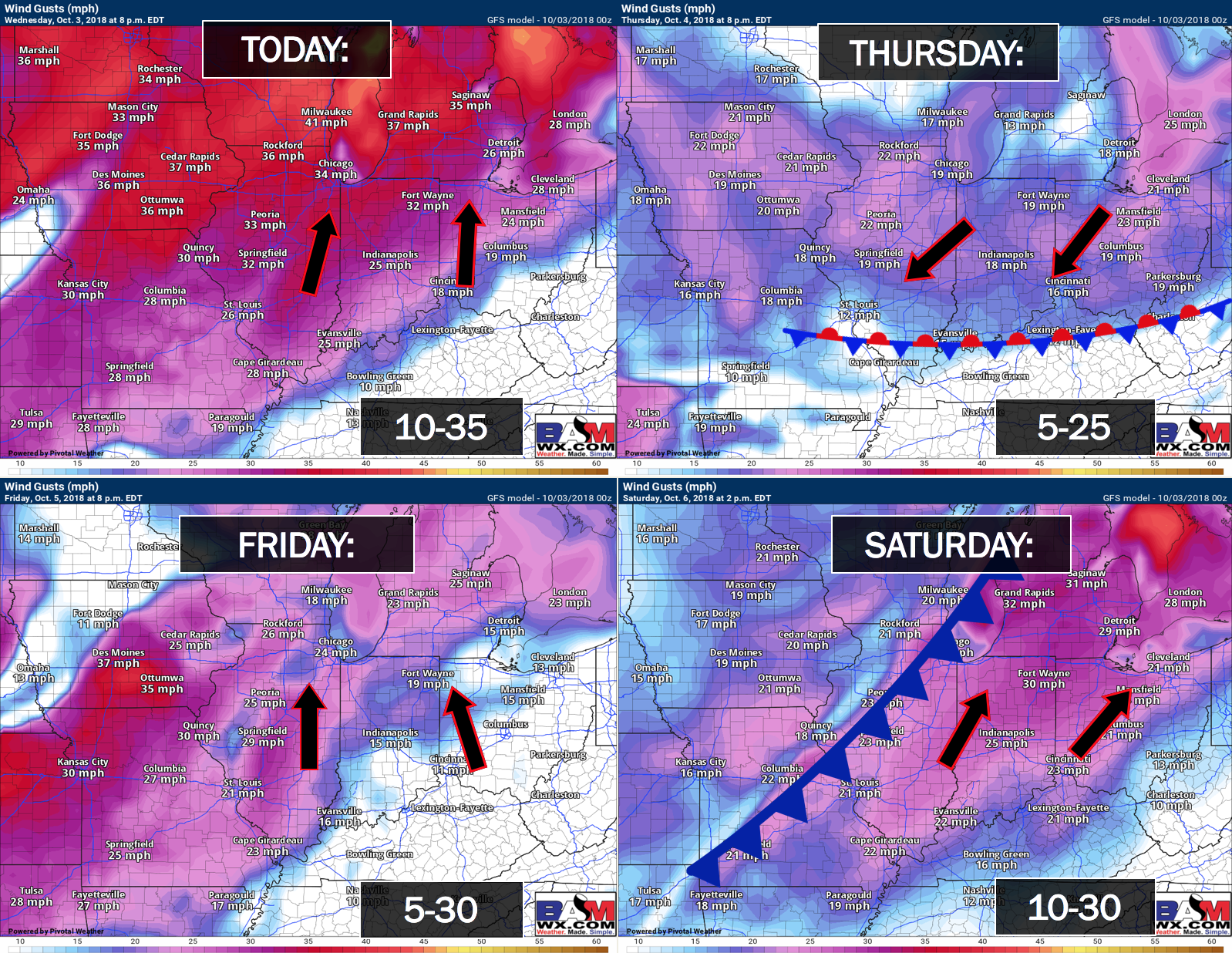
Some gusty winds are possible over the coming days.
Click to enlarge the wind graphic.
Friday through Tuesday
The weekend forecast continues to be a bit of a headache.
The bottom line for Friday and Friday night is that near-record high temperatures and near record high low temperatures are possible. Hot and humid.
A few clouds Friday, but rain chances should hold off.
By Friday night a frontal boundary will slowly inch its way into our western and northern counties. That would include areas from Poplar Bluff, Missouri, to Mt Vernon, Illinois.
A few showers and thunderstorms are possible late Friday night in those areas. Elsewhere, it should remain dry and humid.
By Saturday and Sunday, the frontal boundary will have shifted a bit further east. It will weaken with time and eventually may completely wash out (dissipate).
There will be some clouds and scattered showers and thunderstorms along the front. I have struggled with probability numbers all week.
For now, confidence remains rather low on the extent of precipitation. I continue with 20% to 40% shower and thunderstorm chances Saturday into Sunday night. Monday, as well.
I would not change any weekend plans. Not at this point. I would monitor updated forecasts.
![]()
Here is the preliminary fall outlook from the long-range meteorology team.
Click to enlarge this graphic.
.
![]()
The September forecast has been updated.
![]()

I bring these to you from the BAMwx team. They are excellent long-range forecasters.
Remember, long-range outlooks are a bit of skill, understanding weather patterns, and luck combined. It is not an exact science.

This product is for subscribers.
Subscribe at www.weathertalk.com
Subscriber graphics can be viewed on this page CLICK HERE

This product is for subscribers.

Subscriber graphics can be viewed on this page CLICK HERE
![]()
.
Fall Outlook!
Preliminary October precipitation outlook
Here is the preliminary November temperature and precipitation outlook
Preliminary November temperature outlook
Preliminary November precipitation outlook
.These products are for subscribers.
![]()

A new weather podcast is now available! Weather Geeks (which you might remember is on The Weather Channel each Sunday)
To learn more visit their website. Click here.
![]()

WeatherBrains Episode 663
Joining us as our Guest WeatherBrain this week is a hydrologist in the Research Applications Lab at NCAR. He has a background in hydrology, geology and computer science. In graduate school, he found a happy marriage of these in hydrological modeling, remote sensing, and more recently atmospheric modeling. Ethan Gutmann, welcome to WeatherBrains!
Other discussions in this weekly podcast include topics like:
- Should we re-do hurricane classification?
- Ethan’s hobby of mountain climbing
- U. S. Weather Roundup
- Remnants of Hurricane Rosa entering SW United States
- Astronomy Outlook with Tony Rice
- and more!
.
.
Link to their website https://weatherbrains.com/
Previous episodes can be viewed by clicking here.

We offer interactive local city live radars and regional radars. If a radar does not update then try another one. If a radar does not appear to be refreshing then hit Ctrl F5. You may also try restarting your browser.
The local city view radars also have clickable warnings.
During the winter months, you can track snow and ice by clicking the winterize button on the local city view interactive radars.
You may email me at beaudodson@usawx.com
Find me on Facebook!

Find me on Twitter!

Did you know that a portion of your monthly subscription helps support local charity projects?
You can learn more about those projects by visiting the Shadow Angel Foundation website and the Beau Dodson News website.

I encourage subscribers to use the app vs regular text messaging. We have found text messaging to be delayed during severe weather. The app typically will receive the messages instantly. I recommend people have three to four methods of receiving their severe weather information.
Remember, my app and text alerts are hand typed and not computer generated. You are being given personal attention during significant weather events.
