Saturday, October 28, 2017
See graphics in the comment section of this post. Today’s highlights, certainties, and uncertainties.
It is a hot apple cider day for the region!
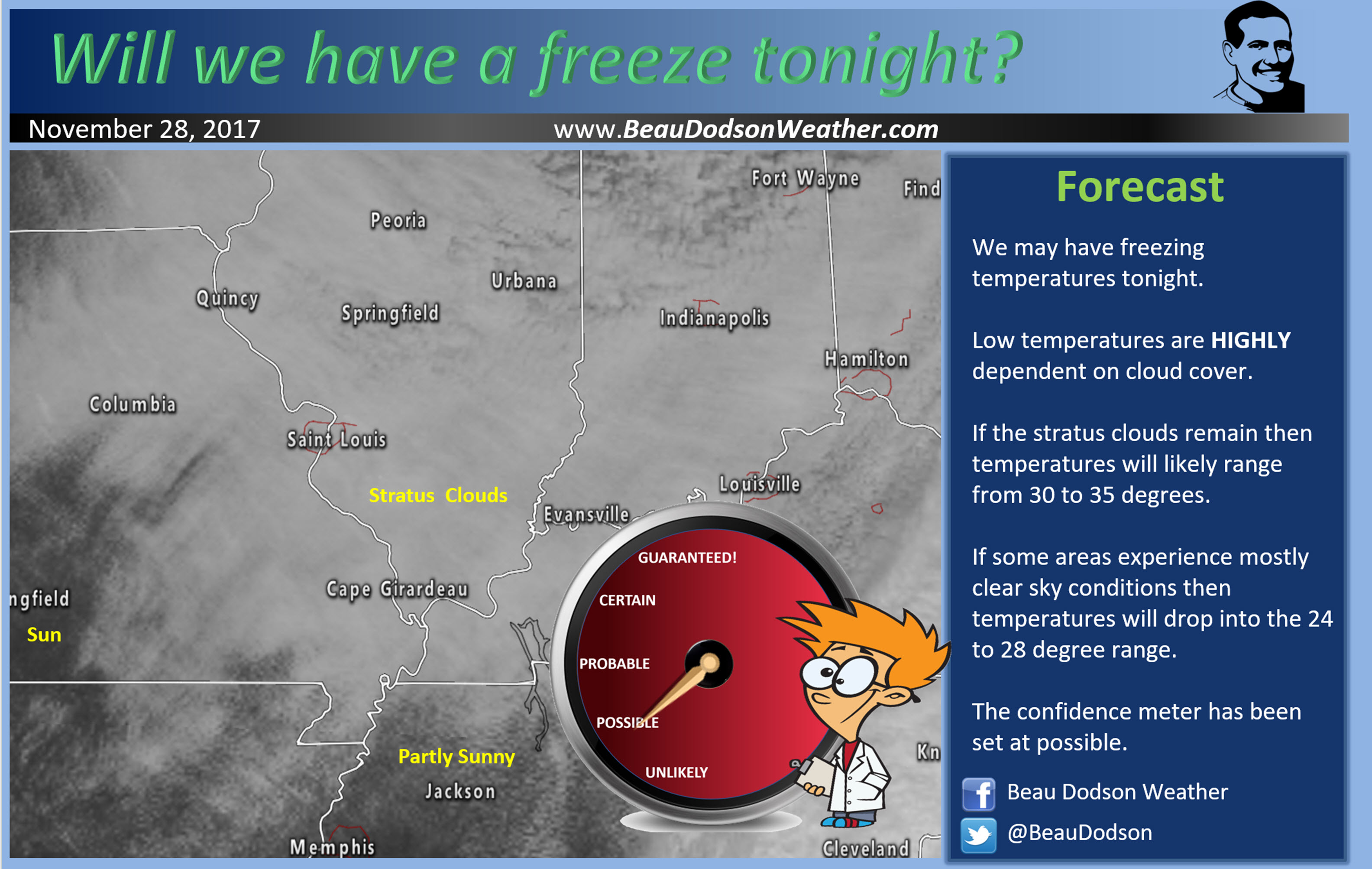
If you have been with me the last few days you will remember me repeatedly saying that today’s forecast uncertainties were centered around stratus clouds.
Stratus clouds are low clouds that often times occur during the fall and winter months. They can occur year-round. They are harder to shake during the cool season.
These clouds are thick and low. If you were flying in an airplane you would take off, enter the clouds, and soon exit the clouds to a nice blue sky.
Confidence was high today that stratus clouds would impact at least southern Illinois and northwest Kentucky. Confidence was lower elsewhere.
Thick stratus clouds have pushed all the way south and west into southeast Missouri and western Kentucky.
A few of you are waking up to sunshine this morning. Look to your north and west. You should see a cloud deck. That is the stratus.
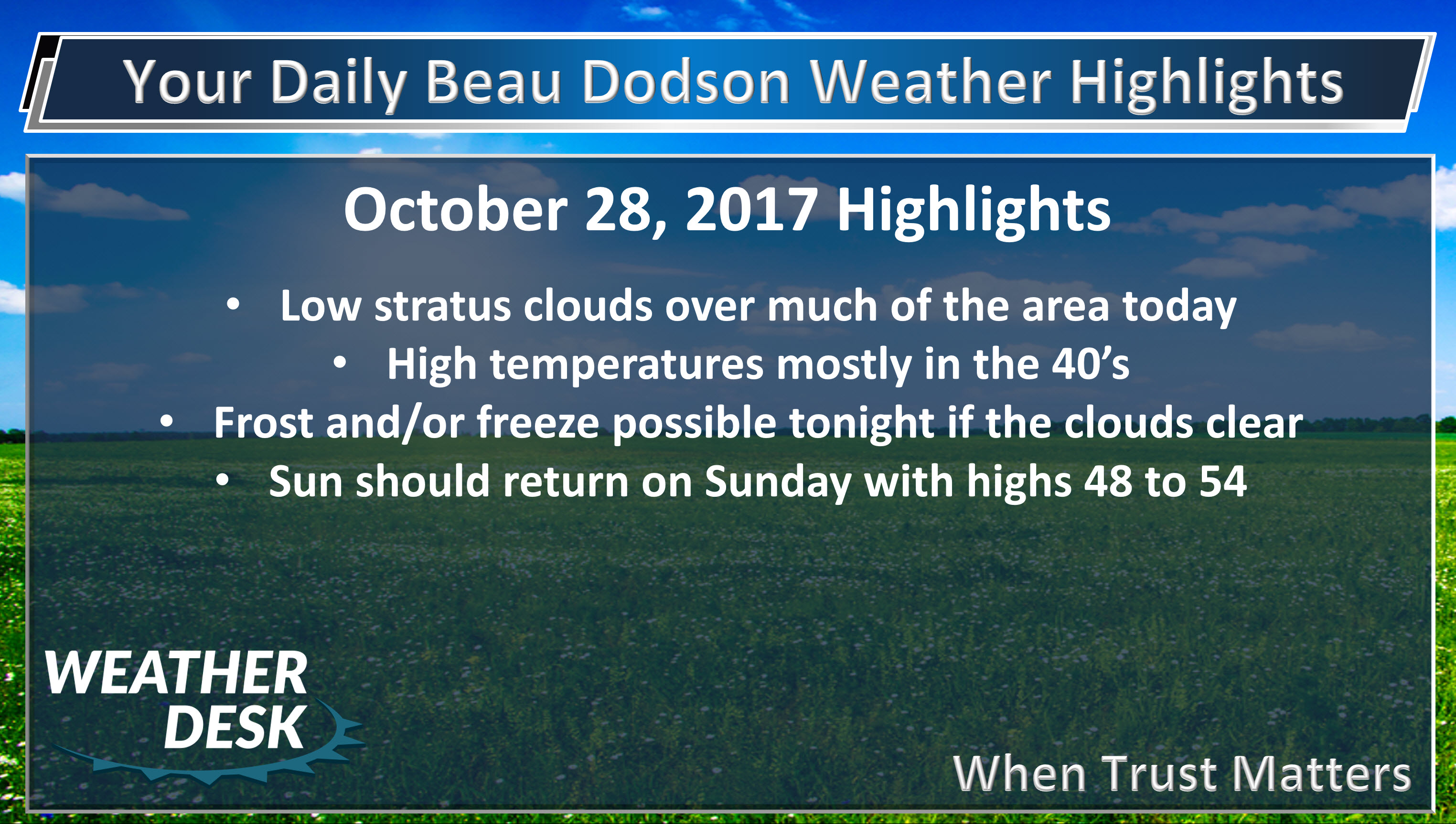
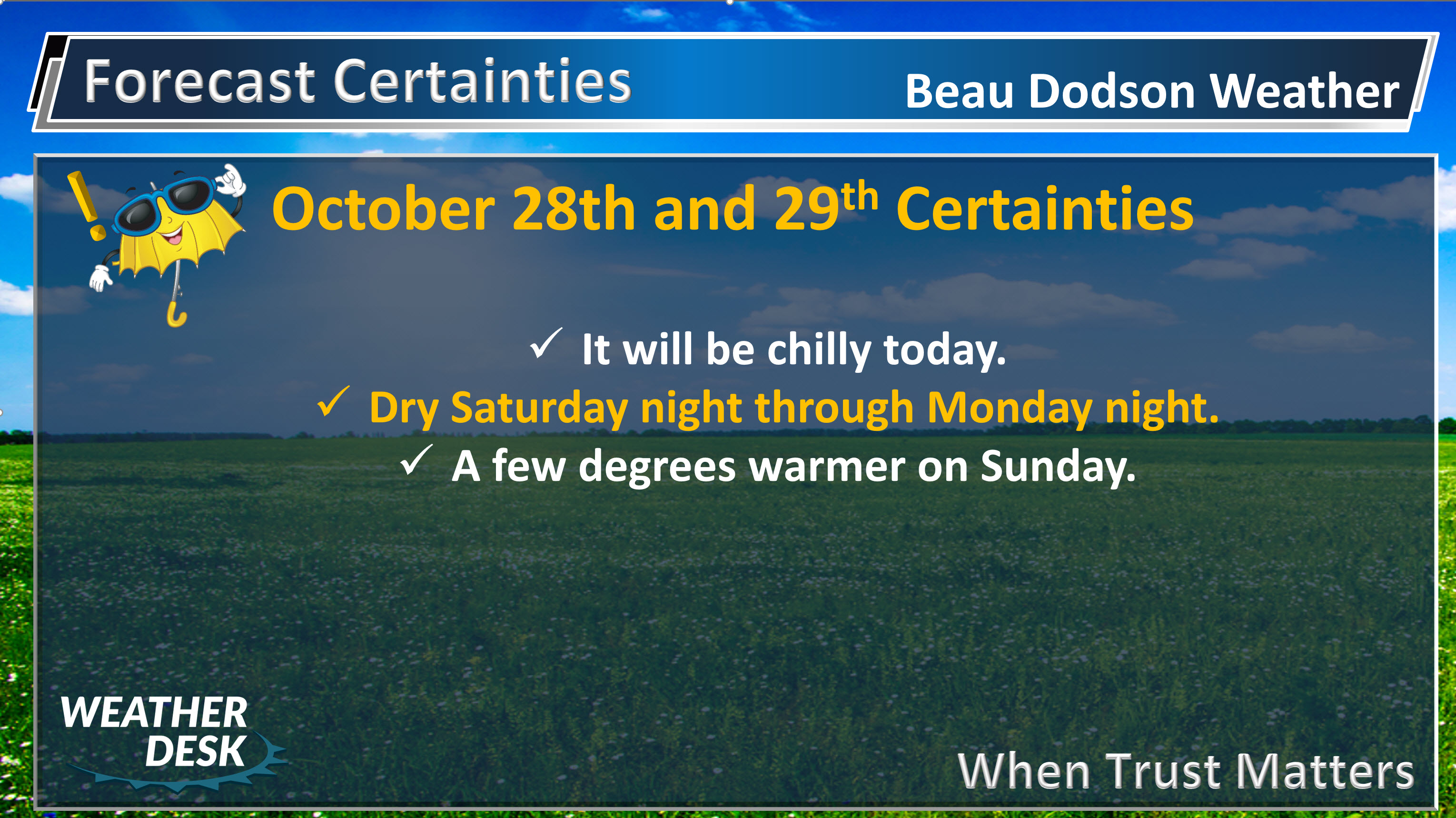
The clouds will be hard to shake today. Often times stratus will mix out and dissipate as the surface of the earth heats up. There won’t be much heating today.
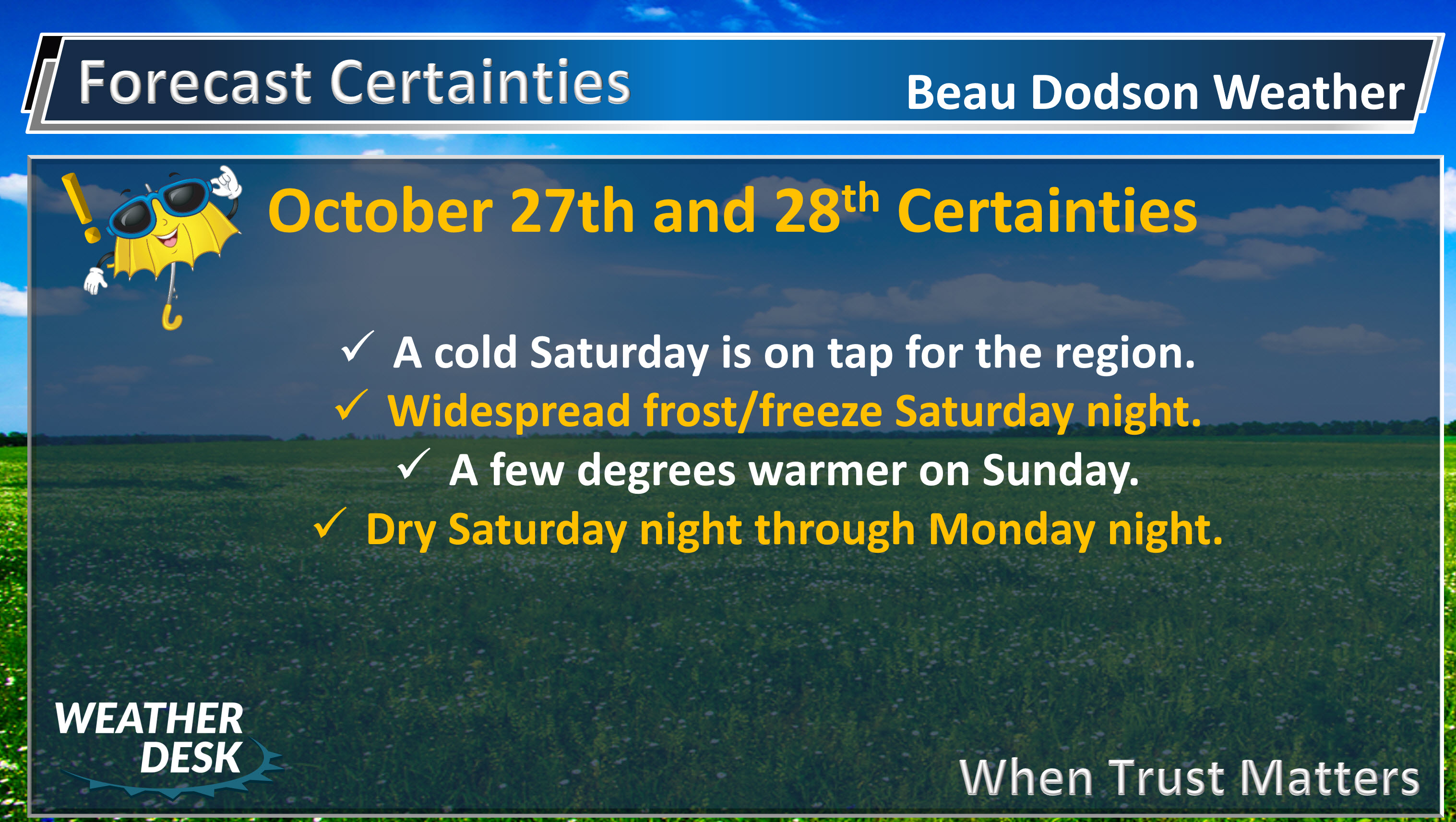
Temperatures today will be 15 to 20 degrees below normal.
Stratus usually erodes from the outside inward.
Temperatures will only rise into the 44 to 48-degree range. If someone squeaks out sunshine then upper 40’s to around 50 is a good bet.
There is a small chance of drizzle or a sleet pellet. The chance of precipitation is small.
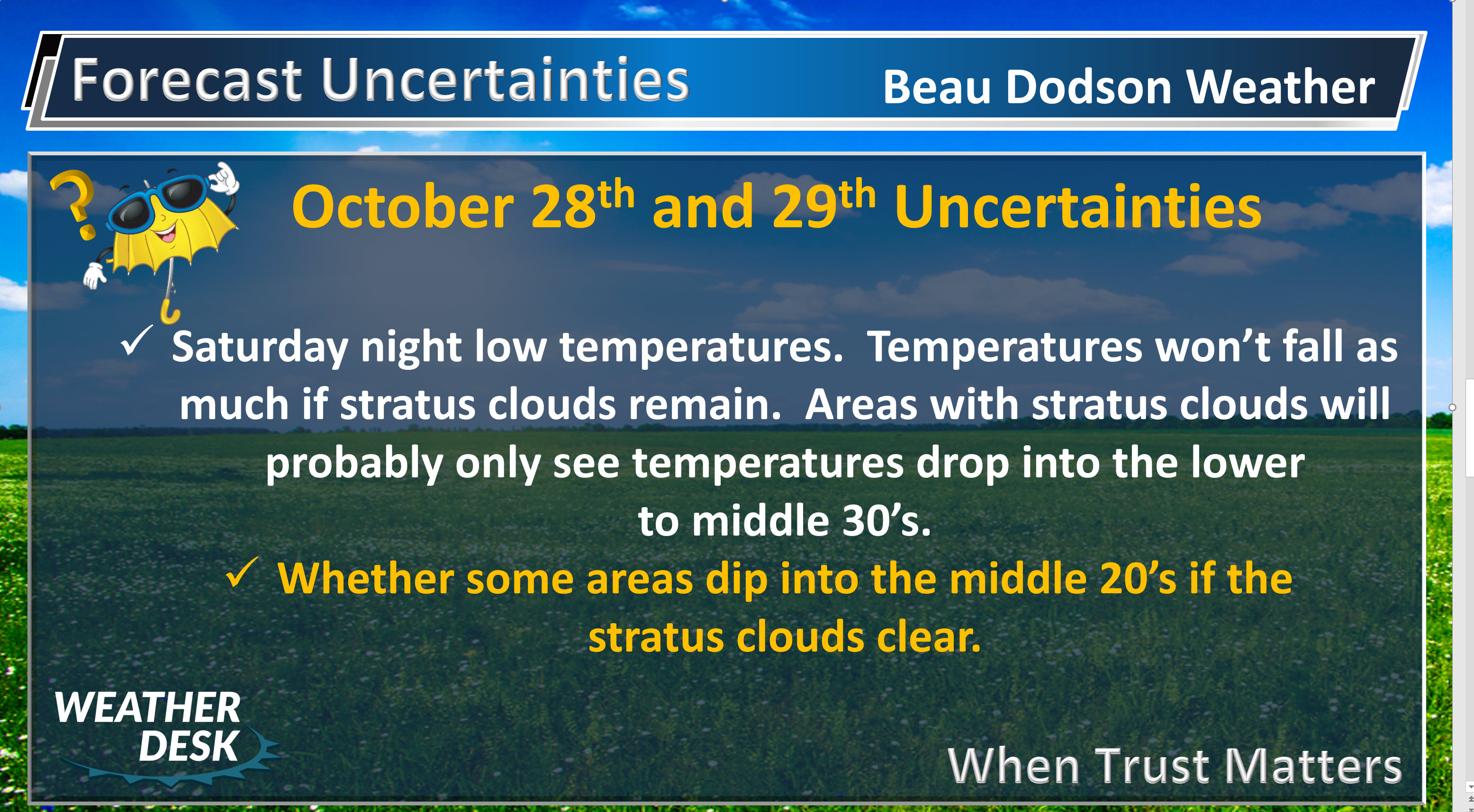
Tonight’s freeze is highly dependent on cloud cover. If clouds don’t clear then temperatures will only fall into the lower and middle 30’s. If the clouds clear then 25 to 30 degrees is a good bet.
Frost is also possible tonight.
The sun should return on Sunday. I will monitor the progress of the stratus clouds. They tend to linger longer than anticipated during October and November, Highs will pop into the 48 to 54-degree range.
Lows Sunday night will probably be more in line with 32 to 38 degrees. We should avoid a freeze on Sunday night. Frost is a possibility.
The next chance of rain arrives Tuesday night and Wednesday.


.
A Weather Talk subscription ($3 a month) is required to view the videos. This helps cover monthly costs (which can run between one and two thousand dollars).
Videos are posted on the www.weathertalk.com website. Once there, click the Beau Video-Cast tab. Long Range Video Update
If you believe you missed a video then you may check the LIVE FEED link on the Weather Talk website. You will find an archive of videos on that page.
You can also receive the videos via your Weather Talk app/text messages. Turn text option FOUR to the on position. The Weather Extra text option. Sign up for the app/text messages, videos, and more at www.beaudodsonweather.com
.
This forecast covers the counties in red. The counties in orange are covered by the forecast discussion further down in the blog.


.
Friday Night Forecast Details:
Forecast: Cloudy. Rain showers likely. Rain ending from west to east. Rain may be mixed with sleet/snow showers especially late. This would mainly be over western Kentucky (further east you go the better the chance). With that said, some light sleet can’t be ruled out in other areas, as well. Turning colder. If sleet/snow were to occur it would just be a novelty and would cause no impacts. We may have a period of clearing late Friday night. If that happens then temperatures will drop a few more degrees.
Temperatures: MO ~ 28 to 34 IL ~ 32 to 38 KY ~ 35 to 40
Winds: Northwest wind 8 to 16 mph. Gusty winds.
What impacts are anticipated from the weather? Wet roadways. Perhaps a freeze where the wind subsides over southeast Missouri. A small chance of frost. The risk would be greater but winds and clouds will likely keep frost from forming.
My confidence in the forecast verifying: High
Is severe weather expected? No
The NWS defines severe weather as 58 mph wind or great, 1″ hail or larger, and/or tornadoes
What is the chance of precipitation? MO ~ 40% IL ~ 60% KY ~ 70% Ending from west to east.
Coverage of precipitation: Scattered to numerous, but ending from west to east late Friday night
Should I cancel my outdoor plans? Have a plan B
.
October 28, 2017
Saturday Forecast Details
Forecast: LOW confidence on Saturday cloud cover forecast. It is possible we end up with sun. Clouds should redevelop from the north. Chilly. A chance of drizzle if stratus clouds develop.
Temperatures: MO ~ 45 to 48 IL ~ 45 to 48 KY ~ 45 to 48
Winds: North and northwest wind at 5 to 10 mph with gusts to 15 mph.
What impacts are anticipated from the weather? Perhaps wet roadways if stratus develops with patchy drizzle. Low confidence.
My confidence in the forecast verifying: LOW
Is severe weather expected? No
The NWS defines severe weather as 58 mph wind or great, 1″ hail or larger, and/or tornadoes
What is the chance of precipitation? MO ~ 5% IL ~ 5% KY ~ 5%
Coverage of precipitation: Spotty drizzle possible if stratus clouds develop. Low confidence.
Should I cancel my outdoor plans? Have a plan B for outdoor events. It will be chilly.
.
Saturday Night Forecast Details:
FREEZE and FROST ALERT
Forecast: Some clouds. Colder. Frost and freeze conditions likely. Freeze conditions will be highly dependent on cloud cover. More clouds and temps won’t fall as much.
Temperatures: MO ~ 28 to 34 (colder if clouds clear) IL ~ 28 to 34 (colder if clouds clear) KY ~ 30 to 35 (colder if clouds clear)
Winds: Light wind.
What impacts are anticipated from the weather? Frost or freeze possible.
My confidence in the forecast verifying: High
Is severe weather expected? No
The NWS defines severe weather as 58 mph wind or great, 1″ hail or larger, and/or tornadoes
What is the chance of precipitation? MO ~ 0% IL ~ 5% KY ~ 5%
Coverage of precipitation: Most likely none. I will be monitoring the stratus clouds over the northeastern part of the region.
Should I cancel my outdoor plans? No
.
October 29, 2017
Sunday Forecast Details
Forecast: Mostly sunny with cool temperatures. A few passing clouds.
Temperatures: MO ~ 50 to 55 IL ~ 48 to 54 KY ~ 48 to 54
Winds: Variable wind at 5 to 10 mph. Winds may become southwest during the afternoon.
What impacts are anticipated from the weather? None
My confidence in the forecast verifying: High
Is severe weather expected? No
The NWS defines severe weather as 58 mph wind or great, 1″ hail or larger, and/or tornadoes
What is the chance of precipitation? MO ~ 0% IL ~ 0% KY ~ 0%
Coverage of precipitation: None
Should I cancel my outdoor plans? No
.
Sunday Night Forecast Details:
Forecast: Mostly clear. Cold. Frost possible. It does appear southerly winds will develop on Sunday afternoon and night. This could mean temperatures will be a bit warmer than recent nights. Not a lot, but a little.
Temperatures: MO ~ 34 to 38 IL ~ 34 to 38 KY ~ 35 to 40
Winds: Southwest wind 5 to 10 mph.
What impacts are anticipated from the weather? Frost possible.
My confidence in the forecast verifying: High
Is severe weather expected? No
The NWS defines severe weather as 58 mph wind or great, 1″ hail or larger, and/or tornadoes
What is the chance of precipitation? MO ~ 0% IL ~ 0% KY ~ 0%
Coverage of precipitation: None
Should I cancel my outdoor plans? No.
.
October 30, 2017
Monday Forecast Details
Forecast: Morning sun. Cool. Some afternoon clouds possible.
Temperatures: MO ~ 55 to 60 IL ~ 55 to 60 KY ~ 55 to 60
Winds: S SW wind becoming NW wind at 6 to 12 mph with gusts to 18 mph
What impacts are anticipated from the weather? None
My confidence in the forecast verifying: High
Is severe weather expected? No
The NWS defines severe weather as 58 mph wind or great, 1″ hail or larger, and/or tornadoes
What is the chance of precipitation? MO ~ 0% IL ~ 0% KY ~ 0%
Coverage of precipitation: None
Should I cancel my outdoor plans? No
.
Monday Night Forecast Details:
Forecast: A period of clouds possible. Otherwise, partly cloudy and cool. Fog possible.
Temperatures: MO ~ 36 to 44 IL ~ 36 to 44 KY ~ 36 to 44
Winds: W NW wind 5 to 10 mph.
What impacts are anticipated from the weather? Perhaps patchy fog.
My confidence in the forecast verifying: Medium
Is severe weather expected? No
The NWS defines severe weather as 58 mph wind or great, 1″ hail or larger, and/or tornadoes
What is the chance of precipitation? MO ~ 0% IL ~ 0% KY ~ 0%
Coverage of precipitation: None
Should I cancel my outdoor plans? No.
.
October 31, 2017
Tuesday Forecast Details
Forecast: Partly sunny. Intervals of clouds. Cool. A cold front may be near the region on Tuesday. I will monitor temperature trends.
Temperatures: MO ~ 55 to 60 IL ~ 55 to 60 KY ~ 55 to 60
Winds: W NW wind at 5 to 10 mph.
What impacts are anticipated from the weather? None
My confidence in the forecast verifying: High
Is severe weather expected? No
The NWS defines severe weather as 58 mph wind or great, 1″ hail or larger, and/or tornadoes
What is the chance of precipitation? MO ~ 0% IL ~ 0% KY ~ 0%
Coverage of precipitation: None
Should I cancel my outdoor plans? No
.
Tuesday Night Forecast Details:
Forecast: Cloudy. A slight chance of a shower. Cool.
Temperatures: MO ~ 38 to 44 IL ~ 38 to 44 KY ~ 38 to 44
Winds: Variable wind 5 to 10 mph.
What impacts are anticipated from the weather? Wet roadways.
My confidence in the forecast verifying: Medium
Is severe weather expected? No
The NWS defines severe weather as 58 mph wind or great, 1″ hail or larger, and/or tornadoes
What is the chance of precipitation? MO ~ 20% IL ~ 20% KY ~ 20%
Coverage of precipitation: Isolated
Should I cancel my outdoor plans? No, but monitor updates
.
November 1, 2017
Wednesday Forecast Details
Forecast: Intervals of clouds. A chance for showers.
Temperatures: MO ~ 55 to 60 IL ~ 55 to 60 KY ~ 55 to 60
Winds: E/SE wind at 5 to 10 mph.
What impacts are anticipated from the weather? Wet roadways
My confidence in the forecast verifying: Medium
Is severe weather expected? No
The NWS defines severe weather as 58 mph wind or great, 1″ hail or larger, and/or tornadoes
Is freezing rain, sleet, or snow expected? No.
What is the chance of precipitation? MO ~ 30% IL ~ 30% KY ~ 30%
Coverage of precipitation: Scattered
Should I cancel my outdoor plans? Monitor updates
.
Wednesday Night Forecast Details:
Forecast: Cloudy. Showers possible.
Temperatures: MO ~ 46 to 52 IL ~ 46 to 50 KY ~ 48 to 52
Winds: Variable winds at 6 to 12 mph.
What impacts are anticipated from the weather? Wet roadways.
My confidence in the forecast verifying: Medium
Is severe weather expected? No
The NWS defines severe weather as 58 mph wind or great, 1″ hail or larger, and/or tornadoes
Is freezing rain, sleet, or snow expected? No.
What is the chance of precipitation? MO ~ 30% IL ~ 30% KY ~ 30%
Coverage of precipitation: Scattered
Should I cancel my outdoor plans? Monitor updates
Beau’s Forecast Certainties
Beau’s Forecast Uncertainties

The National Weather Service definition of a severe thunderstorm is one that produces quarter size hail or larger, 58 mph winds or greater, and/or a tornado.
Friday night through Wednesday: No severe weather concerns.
.

Friday night/Saturday morning: There is a small chance of some light snow or sleet pellets mixed in with the rain after midnight. The greatest chance would be over southeast Illinois and the Pennyrile area of western Kentucky. No impact or accumulation.
Saturday night through Wednesday: Wintry precipitation is not anticipated.

Weather Highlights:
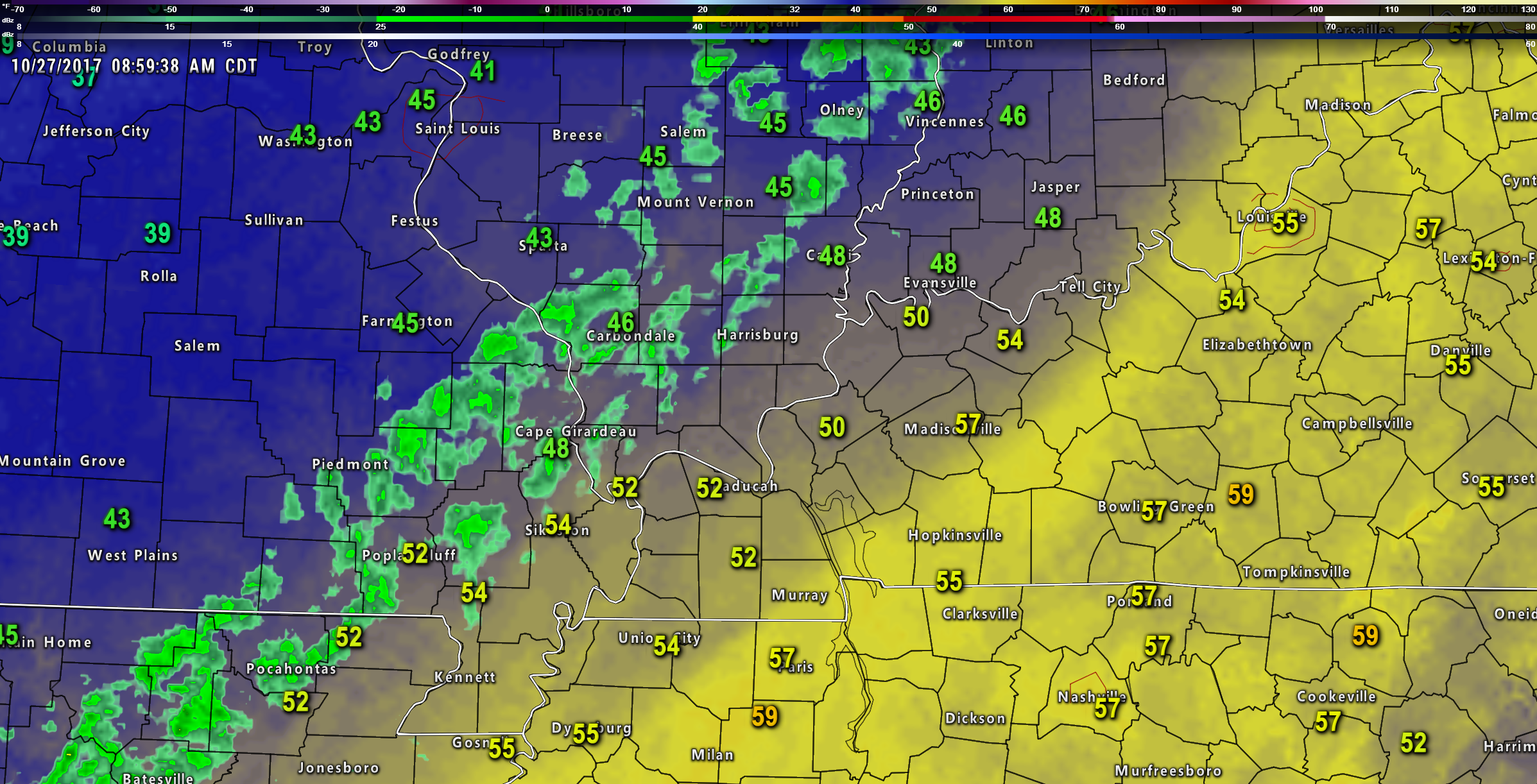
A strong cold front swept through the area on Friday morning and early afternoon.
Rain rapidly developed behind the cold front and spread from west to east.
Here is a radar shot of the system taken at 9 AM (Friday). You can see the precipitation was behind the cold front.
Click image to enlarge.
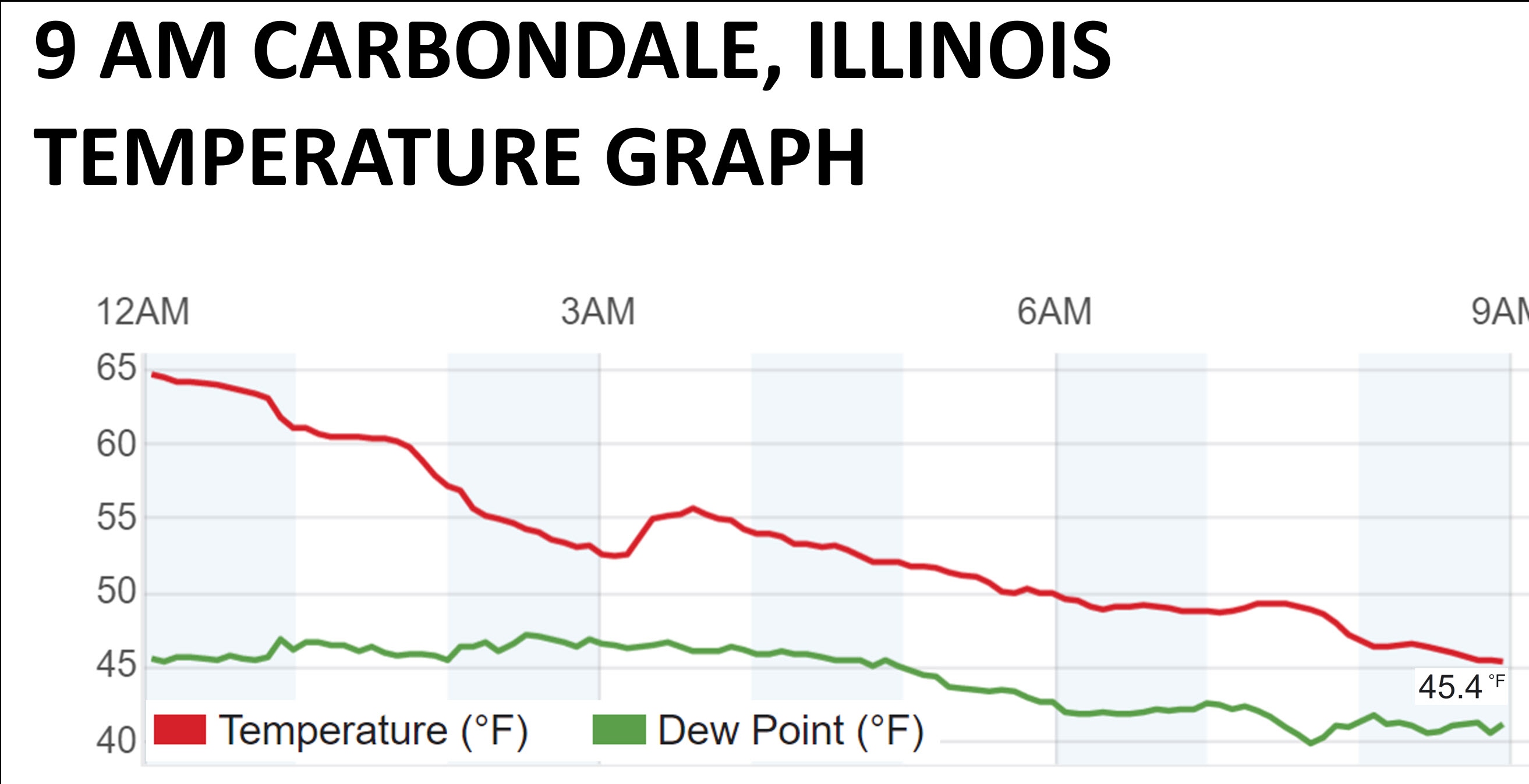
Temperatures reached their highs early in the day and continue to fall as of this typing.
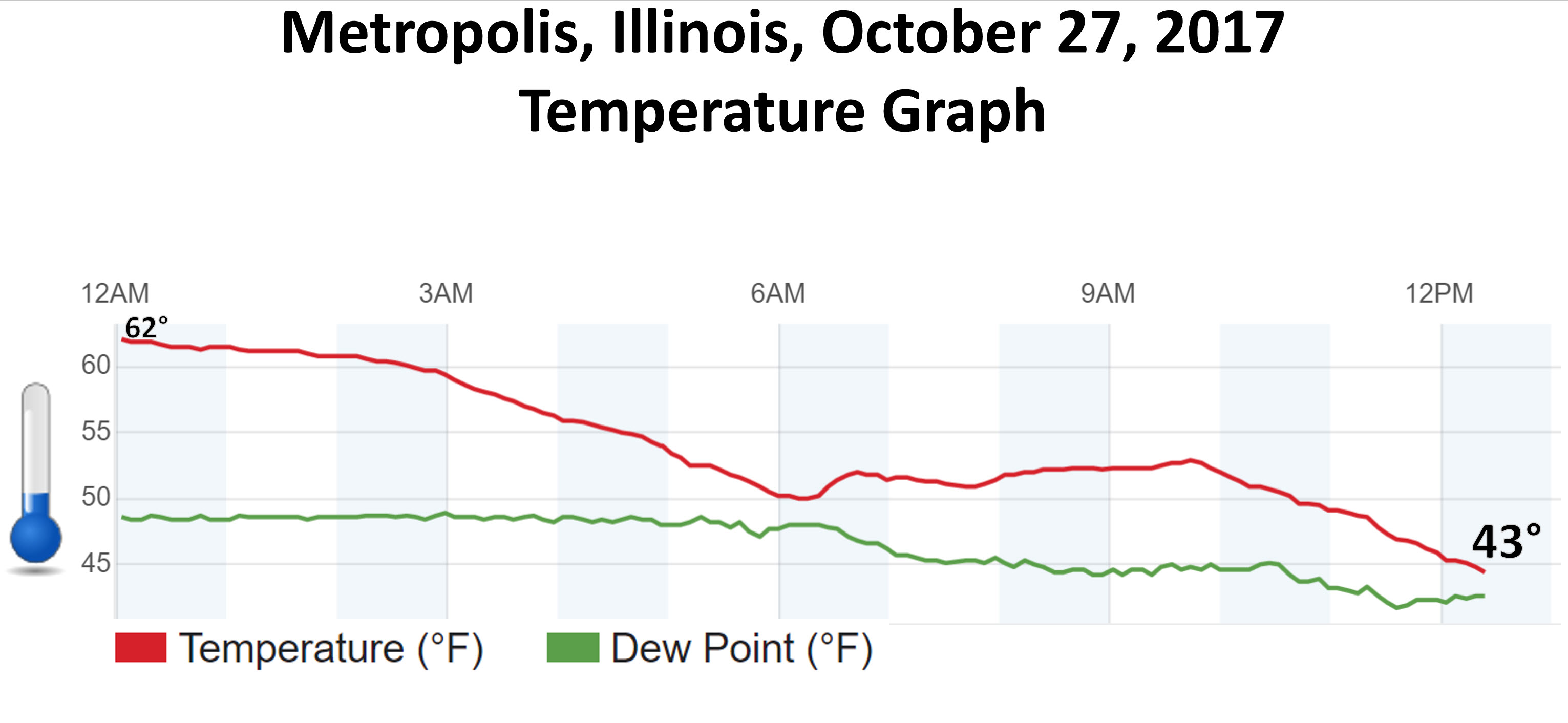
Check out this graphic. This is from Carbondale, Illinois. They were 65 degrees at midnight. They had fallen to 45 degrees by 9 AM.
Here is the Metropolis, Illinois graphic
Friday night weather
Chilly temperatures with rain continuing into the evening hours. Rain will end from west to east as we move through the overnight hours into the early morning hours. There is a small risk for sleet or snow mixed in with the rain. No impact. No concerns.
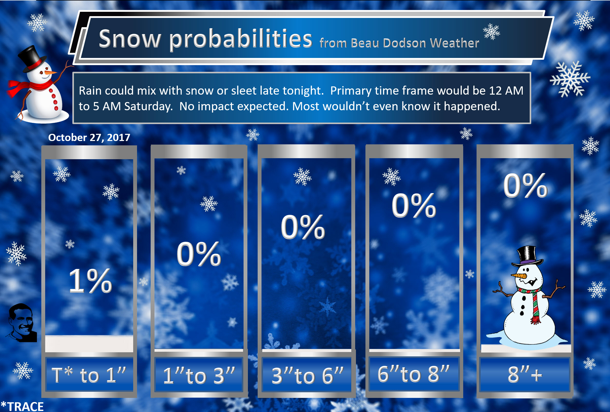
Here is your snow probability forecast. What is the % chance of X amount falling?
It will be breezy tonight. Temperatures by Saturday morning will dip into the 30’s.
It is possible that some areas experience freeze conditions, but with clouds and gusty winds it is unlikely there will be a widespread frost. The greatest risk for freeze conditions would be over northern parts of southeast Missouri and southwest Illinois.
Saturday weather
Big question mark concerning cloud cover on Saturday. Stratus clouds will likely develop to our north on Saturday morning. These clouds will rotate around the upper-level low. Stratus clouds may move back into parts of southeast Missouri, southern Illinois, and northwest Kentucky.
My confidence meter is not all that great.
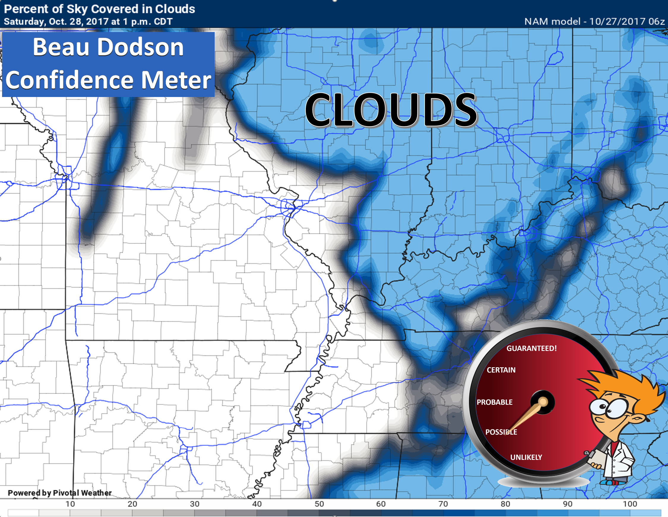
How far south these clouds spread is questionable.
It is possible that there could be quite a bit of sun on Saturday. Lower than normal confidence on this subject.
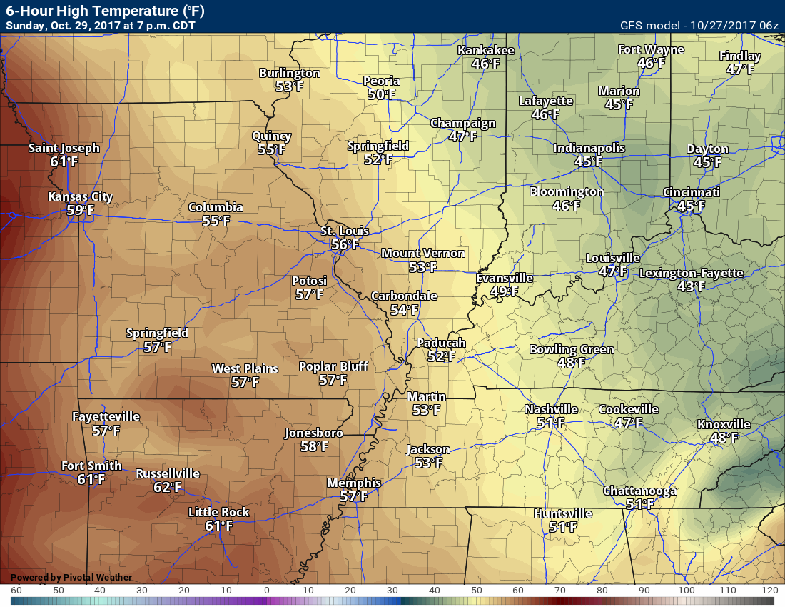
One thing is for sure, it will be chilly on Saturday with gusty winds. Highs will likely not reach 50 degrees in most areas.
Saturday night weather
Frost and freeze alert
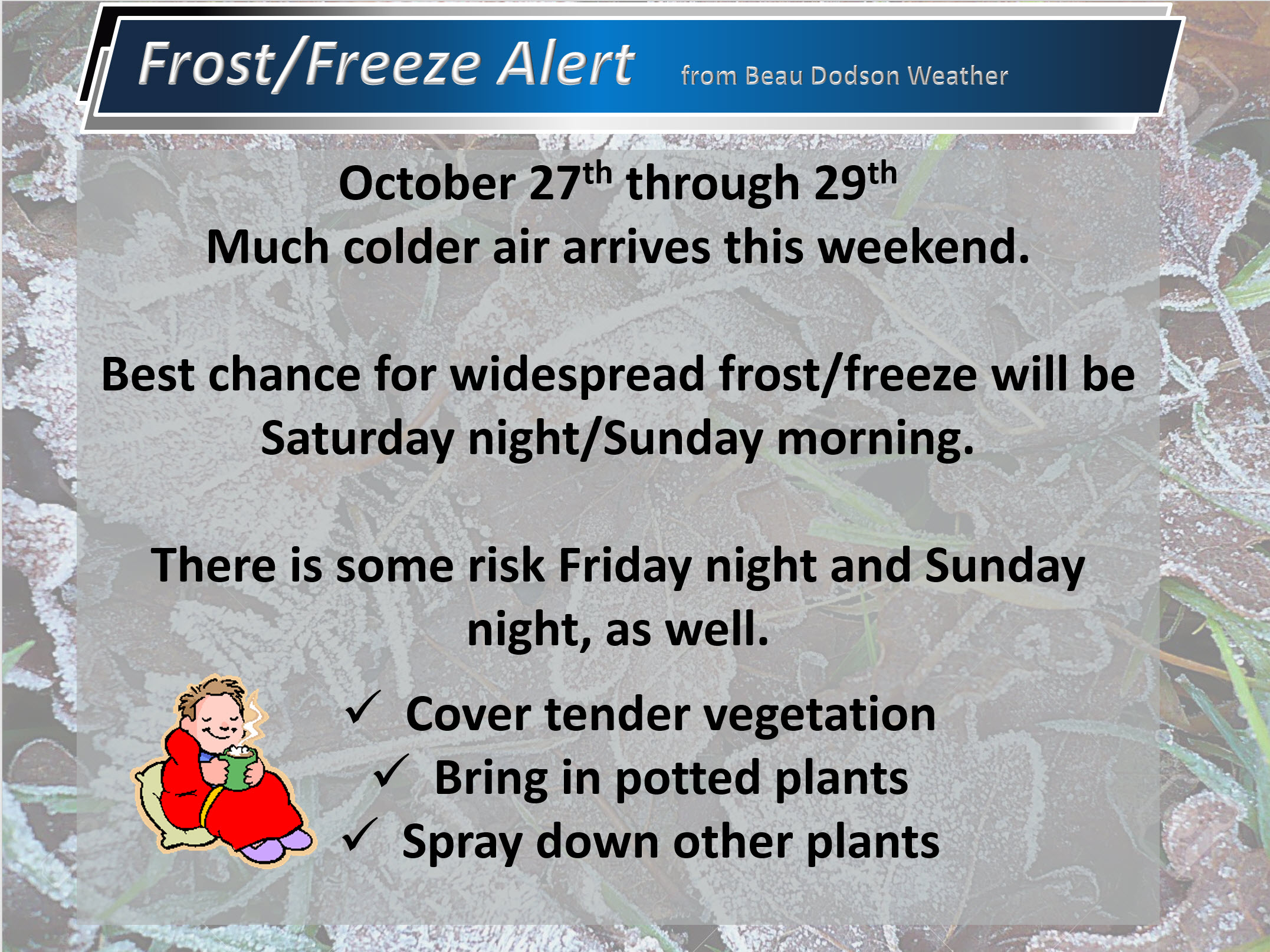
Temperatures on Saturday night will likely dip into the 26 to 34-degree range. If the sky conditions clear then a few spots could even be colder than that. Frost conditions will be highly dependent on cloud cover and winds.
A freeze is likely to occur on Saturday night. Those with sensitive plants may want to take precautions.
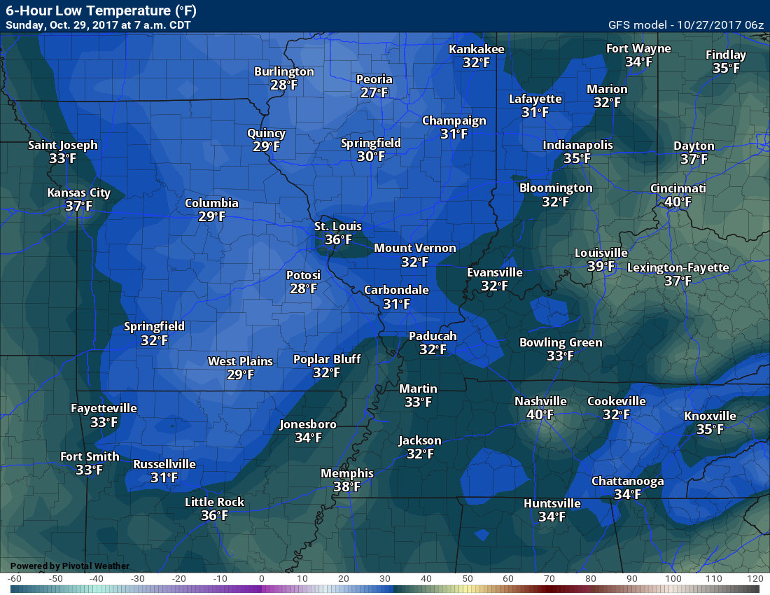
Sunday into Monday
It will be cool on Sunday with mostly sunny sky conditions. A few passing clouds possible. Temperatures should pop into the lower to middle 50’s during the afternoon. Dry, as well.
Temperatures on Sunday night will likely remain above freezing. I am forecasting 34 to 38-degree readings. There has been a trend for slightly warmer overnight lows. The winds will become southerly on Sunday afternoon and night. That may prevent temperatures from falling as much as they would with a northerly wind.
Either way, there is some risk for frost on Sunday night, as well.
Dry conditions Sunday night and Monday.
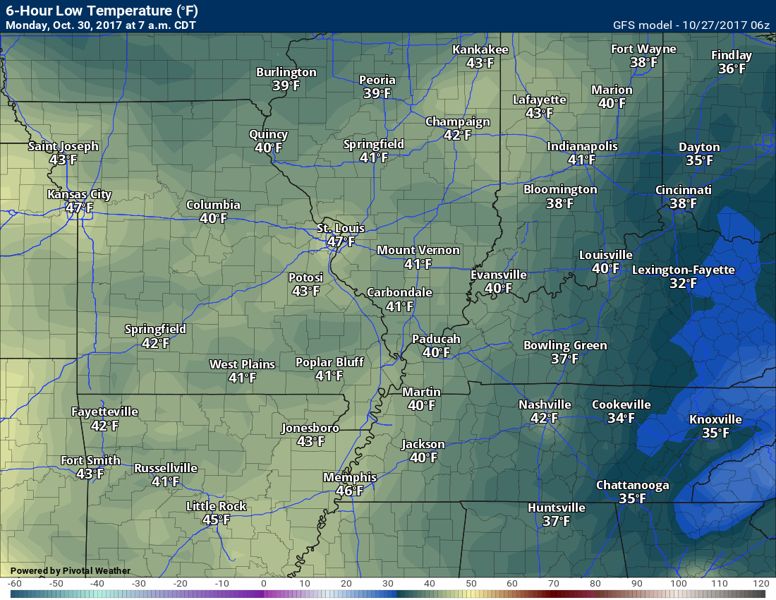
We will warm into the upper 50’s on Monday. Perhaps a 60-degree reading. The trend has been slightly warmer.
A cold front arrives Monday night into Tuesday. This front may remain in the region for a few days.
Tuesday and Wednesday
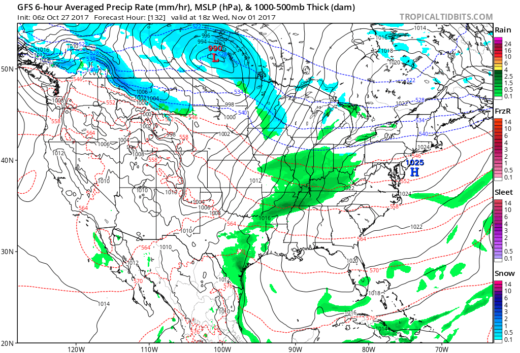
Clouds will thicken on Tuesday and especially Tuesday night. Rain showers will be possible Tuesday night, but more likely on Wednesday. Too soon to know rain totals from that system.
Highs on Tuesday and Wednesday will likely range from 54 to 58 degrees. Some of the guidance does show 58 to 64-degree readings. I will monitor the trends in the guidance.
At this time, severe weather does not appear to be a concern through Wednesday.
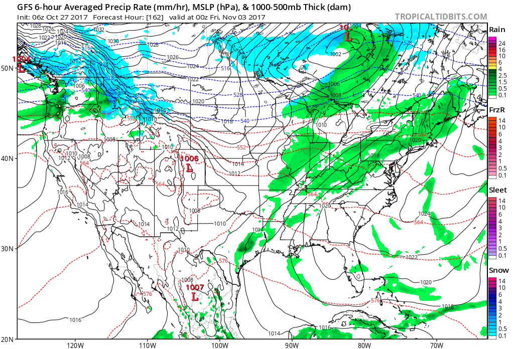
Guidance lingers rain in the region on Thursday and perhaps Friday. We still have several days to monitor this part of the forecast.
GFS model future-cast radar for next Wednesday. Green is rain. Blue is snow.
Thursday
Temperature Forecast from the GFS model guidance
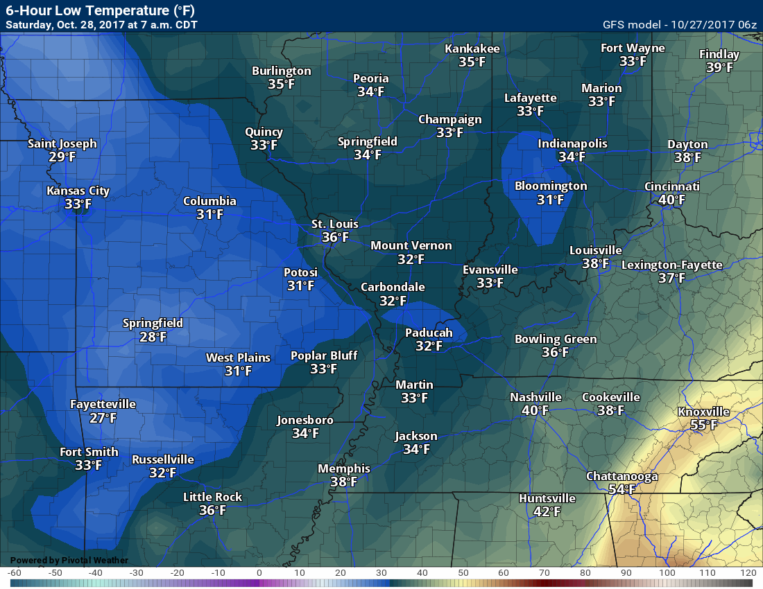
Friday night low temperatures
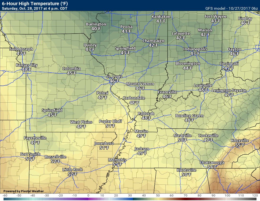
Keep in mind these are model guidance projections. Temperatures could vary considerably across the region.
Saturday high temperatures
Saturday night low temperatures
Sunday high temperatures
Sunday night low temperatures
There is some debate about Monday morning temperatures. They could be several degrees colder than shown by the GFS guidance (below)
Are you subscribing to Weather Talk app/text messages and videos? This is what helps support all of the data you see each day.
We now offer premium videos for the short and long-range forecasts! These videos are produced by a team of long-range forecast experts. They are brought to you as bonus information. Activate text option four in order to receive these on your app or via text.
Subscribe at www.beaudodsonweather.com
We offer an Apple and Android app (scroll to the bottom of this page for more information).

Were you aware that I hired a team of meteorologists for long range videos?
To learn more, click this link
http://cms.weathertalk.com/meet-the-team/
.


We offer regional radars and local city radars – if a radar does not update then try another one. Occasional browsers need their cache cleared. You may also try restarting your browser. This will usually fix any problems.
During the winter you can track snow and ice by clicking the winterize button on the local city view interactive radars.
You may email me at beaudodson@usawx.com
Interactive Weather Radar Page. Choose the city nearest your location: Click this link
National interactive radar: Click this link.
The Beau Dodson Weather APP is ready for Apple and Android users. The app provides a faster way for you to receive my text messages. ATT and Verizon are not always reliable when it comes to speed.
Some of you have asked if you can receive the texts on your phone and the app. The answer to that is, yes. The Android app will automatically allow that to happen. On the Apple app, however, you will need to open your app and click the settings button. Make sure the green tab is OFF. Off means you will still receive the texts to your phone and the app. If you have any questions, then email me at beaudodson@usawx.com
The app is for text subscribers.
The direct download, for the Apple app, can be viewed here
https://itunes.apple.com/us/app/id1190136514
Here is the download link for the Android version Click Here
If you have not signed up for the texting service then you may do so at www.beaudodsonweather.com


——————————————————–
Your support helps with the following:

and

.

Whom do you trust for your weather information?
I have studied weather, in our region, since the late 1970’s. I have 40 years of experience in observing our regions weather patterns. My degree is in Broadcast Meteorology and a Bachelor’s of Science.
My resume includes:
Member of the American Meteorological Society.
NOAA Weather-Ready Nation Ambassador.
Meteorologist for McCracken County Emergency Management. I served from 2005 through 2015.
Meteorologist for McCracken County Rescue. 2015 through current
I own and operate the Southern Illinois Weather Observatory.
I am the chief meteorologist for Weather Talk LLC.
I am also a business owner in western Kentucky.
Recipient of the Mark Trail Award, WPSD Six Who Make A Difference Award, Kentucky Colonel, and the Caesar J. Fiamma” Award from the American Red Cross.
In 2005, I helped open the largest American Cross shelter in U.S. history. This was in Houston, Texas. I was deployed to help with the aftermath of Hurricane Katrina and Hurricane Rita. I was a shelter manager of one of the Houston, Texas shelter divisions.
In 2009 I was presented with the Kentucky Office of Highway Safety Award.
Recognized by the Kentucky House of Representatives for my service to the State of Kentucky leading up to several winter storms and severe weather outbreaks.
If you click on the image below you can read the Kentucky House of Representatives Resolution.

I am President of the Shadow Angel Foundation which serves portions of western Kentucky and southern Illinois.
There is a lot of noise on the internet. A lot of weather maps are posted without explanation. You need a trusted source for information.
My forecast philosophy is simple and straight forward.
- Communicate in simple terms
- To be as accurate as possible within a reasonable time frame before an event
- Interact with you on Twitter, Facebook, email, texts, and this blog
- Minimize the “hype” that you might see through other weather sources
- Push you towards utilizing wall-to-wall LOCAL TV coverage during severe weather events

Sign up for my AWARE email by clicking here.
I typically send AWARE emails before severe weather, winter storms, or other active weather situations. I do not email watches or warnings. The emails are a basic “heads up” concerning incoming weather conditions