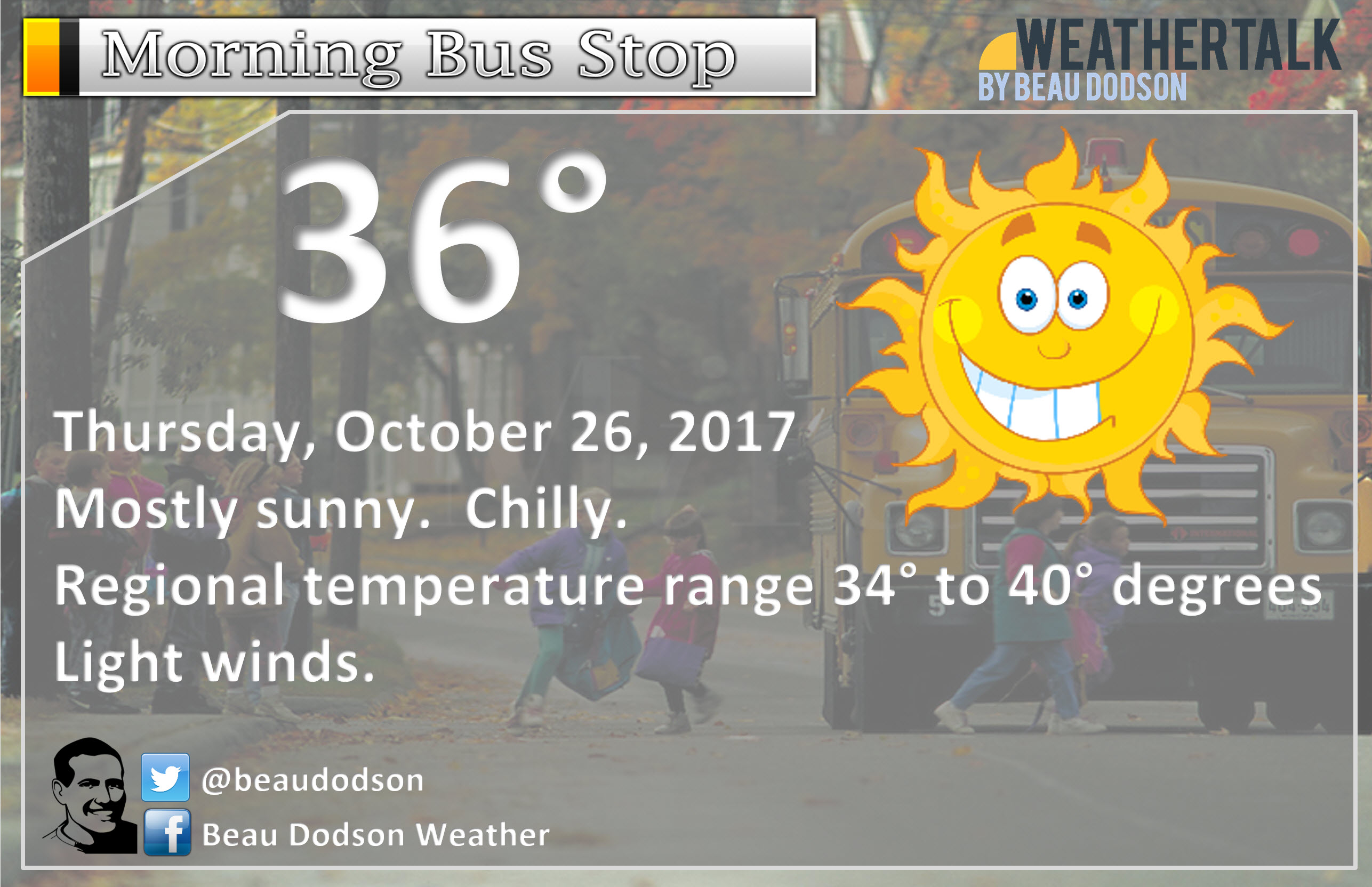
Thursday early morning update
October 26, 2017
Severe weather is not anticipated through Wednesday.
Highlights
1. Beautiful today
2. Cold on Friday with rain
3. Frost/freeze possible Saturday and Sunday night
Beautiful day on tap for the region.
Temperatures will rise into the 70’s by this afternoon! It will feel like spring.
Some increase in clouds late tonight. A cold front will enter our western counties after 4 am.
Friday and Friday night
Clouds will thicken on Friday. A cold front will move across the region during the morning hours.
High temperatures will occur early in the day. Temperatures will fall through the day. By evening temperatures will have fallen into the 40’s.
Rain will develop along and behind the cold front. There remain questions about how far southeast the rain will form.
The lowest rainfall totals will likely be over southeast Missouri and perhaps southwest Illinois.
The further east you travel in southern Illinois and western Kentucky, the greater the rainfall totals.
Rain totals for southeast Missouri and southwest Illinois will generally range from 0.10″ to 0.30″.
It is possible the Poplar Bluff area towards Farmington will see very little in the way of measurable rainfall. Keep that in mind.
Rain totals for southeast Illinois and western Kentucky/northwest Tennessee will generally run from 0.30″ to 0.60″ with pockets of greater than 0.75″.
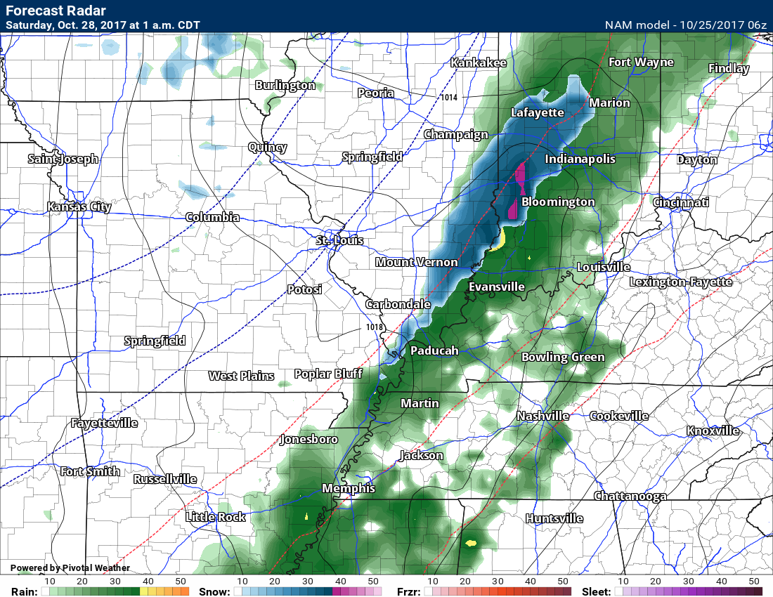
Colder air will continue to filter into the region on Friday night/Saturday morning. Rain could mix with some sleet pellets and snowflakes. No accumulation or impact anticipated. Best chances would be between 12 am and 5 am Saturday.
Saturday into Sunday night
Clouds should linger on Saturday. Sprinkle or sleet pellet/snow flurry possible early. Cold. Raw day. Highs only in the 40’s.
Lows Saturday night from 28 to 34 degrees. If the clouds clear then a frost/freeze possible Saturday night.
Mostly sunny on Sunday with highs near 50 degrees.
Mostly clear Sunday night with lows from 28 to 34 degrees. A frost/freeze possible Sunday night.
Dry on Monday and probably Tuesday. Rain showers may reappear Tuesday night/Wednesday. Still some time to monitor that system. Highs on Monday and Tuesday in the 55 to 60 degree range.


.
A Weather Talk subscription ($3 a month) is required to view the videos. This helps cover monthly costs (which can run between one and two thousand dollars).
Videos are posted on the www.weathertalk.com website. Once there, click the Beau Video-Cast tab. Long Range Video Update
If you believe you missed a video then you may check the LIVE FEED link on the Weather Talk website. You will find an archive of videos on that page.
You can also receive the videos via your Weather Talk app/text messages. Turn text option FOUR to the on position. The Weather Extra text option. Sign up for the app/text messages, videos, and more at www.beaudodsonweather.com
.
This forecast covers the counties in red. The counties in orange are covered by the forecast discussion further down in the blog.


.
October 25, 2017
Wednesday Night Forecast Details:
Forecast: Clearing. Cool. Perhaps some patchy frost. Fog possible, esp over southern Illinois and northwest Kentucky.
Temperatures: MO ~ 40 to 44 IL ~ 37 to 42 KY ~ 38 to 42
Winds: Variable wind at 4 to 8 mph
What impacts are anticipated from the weather? Patchy fog and frost possible.
My confidence in the forecast verifying: High
Is severe weather expected? No
The NWS defines severe weather as 58 mph wind or great, 1″ hail or larger, and/or tornadoes
What is the chance of precipitation? MO ~ 0% IL ~ 0% KY ~ 0%
Coverage of precipitation: None
Should I cancel my outdoor plans? No
.
October 26, 2017
Thursday Forecast Details
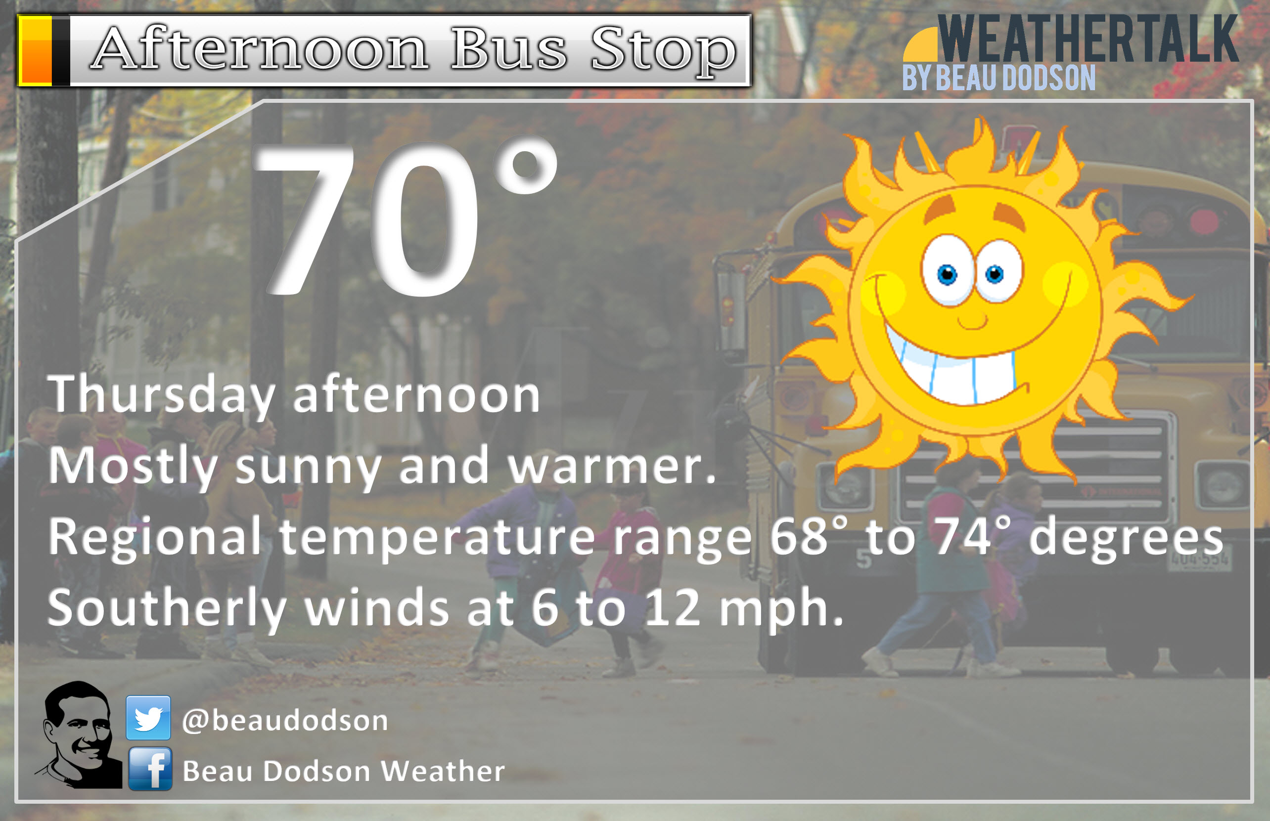
Forecast: Mostly sunny. Warmer. Nice day.
Temperatures: MO ~ 74 to 78 IL ~ 68 to 74 KY ~ 68 to 74
Winds: South and southeast wind 4 to 8 mph with gusts to 15 mph. Winds becoming gusty in the afternoon.
What impacts are anticipated from the weather? None
My confidence in the forecast verifying: High
Is severe weather expected? No
The NWS defines severe weather as 58 mph wind or great, 1″ hail or larger, and/or tornadoes
What is the chance of precipitation? MO ~ 0% IL ~ 0% KY ~ 0%
Coverage of precipitation: None
Should I cancel my outdoor plans? No
.
Thursday Night Forecast Details:
Forecast: Becoming windy. Clear early. Increasing clouds late. A 20% of a shower after 4 am. Not as cold.
Temperatures: MO ~ 48 to 54 IL ~ 48 to 54 KY ~ 48 to 54
Winds: South wind 8 to 16 mph with gusts to 25 mph winds
What impacts are anticipated from the weather? Small chance for wet roads after 4 am. Gusty winds developing.
My confidence in the forecast verifying: High
Is severe weather expected? No
The NWS defines severe weather as 58 mph wind or great, 1″ hail or larger, and/or tornadoes
What is the chance of precipitation? MO ~ 30% late IL ~ 20% late KY ~ 10% late
Coverage of precipitation: Perhaps isolated to scattered late at night.
Should I cancel my outdoor plans? No
.
October 27, 2017
Friday Forecast Details
Forecast: Cloudy. Rain developing. Rain may develop further southeast. That brings questions as far as rain for southeast Missouri and southwest Illinois. A cold front will move through early in the day. Temperatures will fall through the day. Clouds and precipitation possible behind the cold front.
Temperatures: MO ~ 56 to 62 IL ~ 56 to 62 KY ~ 60 to 64 Falling temperatures as we move through the day.
Winds: Variable wind 7 to 14 mph. Winds becoming west/northwest at 8 to 16 mph. Higher gusts possible.
What impacts are anticipated from the weather? Wet roadways.
My confidence in the forecast verifying: Low to medium
Is severe weather expected? No
The NWS defines severe weather as 58 mph wind or great, 1″ hail or larger, and/or tornadoes
What is the chance of precipitation? MO ~ 40% IL ~ 70% KY ~ 70%
Coverage of precipitation: Perhaps numerous over parts of southern Illinois and western Kentucky.
Should I cancel my outdoor plans? Have a plan B for the afternoon.
.
Friday Night Forecast Details:
Forecast: Cloudy. Rain showers perhaps mixed with sleet/snow showers. Turning colder. If sleet/snow were to occur it would likely be just a novelty and should not stick.
Temperatures: MO ~ 34 to 38 IL ~ 34 to 38 KY ~ 35 to 40
Winds: Northwest wind 8 to 16 mph. Gusty winds.
What impacts are anticipated from the weather? Wet roadways. Perhaps scattered frost where the wind subsides. Valleys, as well.
My confidence in the forecast verifying: Medium
Is severe weather expected? No
The NWS defines severe weather as 58 mph wind or great, 1″ hail or larger, and/or tornadoes
What is the chance of precipitation? MO ~ 40% IL ~ 60% KY ~ 70%
Coverage of precipitation: Scattered to numerous, but ending from west to east late Friday night
Should I cancel my outdoor plans? Have a plan B
.
October 28, 2017
Saturday Forecast Details
Forecast: Mostly cloudy. Cold. Light rain possible. Rain could be mixed with a pellet of sleet or a snowflake. No impact. There are questions about how fast clouds depart on Saturday. If stratus clouds remain then temperatures will be chilly.
Temperatures: MO ~ 44 to 48 IL ~ 44 to 48 KY ~ 44 to 48
Winds: North and northwest wind at 5 to 10 mph.
What impacts are anticipated from the weather? Perhaps wet roadways early.
My confidence in the forecast verifying: LOW
Is severe weather expected? No
The NWS defines severe weather as 58 mph wind or great, 1″ hail or larger, and/or tornadoes
What is the chance of precipitation? MO ~ 20% IL ~ 20% KY ~ 30%
Coverage of precipitation: Spotty light precipitation possible.
Should I cancel my outdoor plans? No, but monitor updates. Should be a raw day.
.
Saturday Night Forecast Details:
Forecast: Some clouds. Colder. Frost or freeze possible if clouds depart.
Temperatures: MO ~ 28 to 34 IL ~ 28 to 34 KY ~ 30 to 35
Winds: Light wind.
What impacts are anticipated from the weather? Frost or freeze possible.
My confidence in the forecast verifying: Medium
Is severe weather expected? No
The NWS defines severe weather as 58 mph wind or great, 1″ hail or larger, and/or tornadoes
What is the chance of precipitation? MO ~ 0% IL ~ 0% KY ~ 0%
Coverage of precipitation: None
Should I cancel my outdoor plans? No
.
October 28, 2017
Sunday Forecast Details
Forecast: Mostly sunny and cool.
Temperatures: MO ~ 48 to 54 IL ~ 46 to 52 KY ~ 46 to 52
Winds: Variable wind at 5 to 10 mph.
What impacts are anticipated from the weather? None
My confidence in the forecast verifying: High
Is severe weather expected? No
The NWS defines severe weather as 58 mph wind or great, 1″ hail or larger, and/or tornadoes
What is the chance of precipitation? MO ~ 0% IL ~ 0% KY ~ 0%
Coverage of precipitation: None
Should I cancel my outdoor plans? No
.
Sunday Night Forecast Details:
Forecast: Mostly clear. Cold. Frost or freeze likely.
Temperatures: MO ~ 28 to 34 IL ~ 28 to 34 KY ~ 30 to 35
Winds: Light wind.
What impacts are anticipated from the weather? Frost or freeze possible.
My confidence in the forecast verifying: Medium
Is severe weather expected? No
The NWS defines severe weather as 58 mph wind or great, 1″ hail or larger, and/or tornadoes
What is the chance of precipitation? MO ~ 0% IL ~ 0% KY ~ 0%
Coverage of precipitation: None
Should I cancel my outdoor plans? No.
.
.

The National Weather Service definition of a severe thunderstorm is one that produces quarter size hail or larger, 58 mph winds or greater, and/or a tornado.
Thursday through Tuesday: No severe weather concerns.

Weather Highlights:
I hope you are having a nice week! It has actually felt a bit more like autumn. Shocker! I was starting to forget what cold air felt like.
We have a little bit of everything in the forecast for the coming days. Let me break it down.
Wednesday night into Thursday night
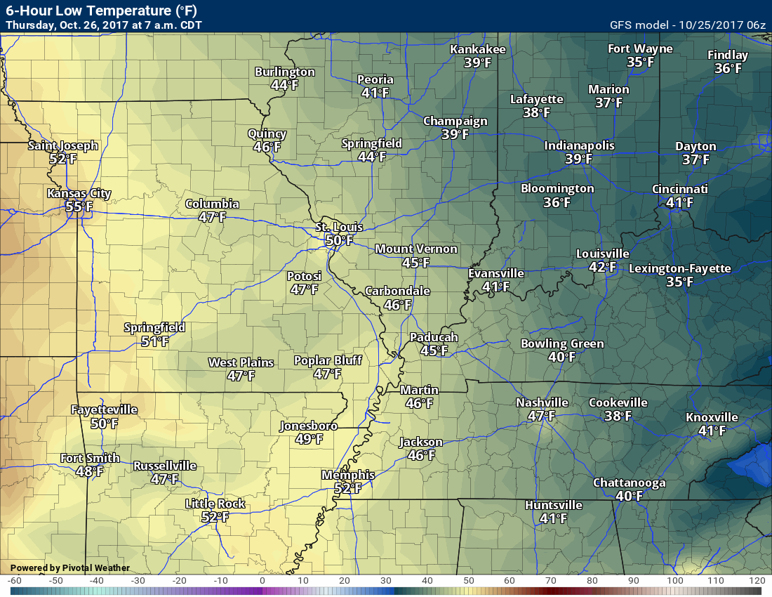
It will be chilly as we move into Thursday morning. The winds should subside. Clouds should clear. That will leave us with overnight lows in the 36 to 44-degree range across the region.
I can’t rule out light frost over southeast Illinois and northwestern Kentucky. The impact would be minimal.
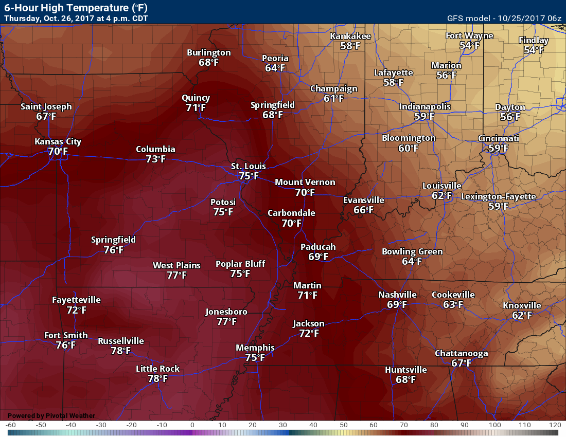
Thursday is the pick day of the week! High temperatures will rise into the 68 to 74-degree range. It will feel like spring outside.
Try to enjoy Thursday, because the weather will go downhill after that. we should have plenty of sunshine on Thursday.
Winds will pick up, ahead of a cold front, on Thursday night. Temperatures will be warmer ahead of it, as well. Lows on Thursday night won’t be as cold as recent nights.
There may be an increase in clouds late Thursday night.
Friday into Sunday
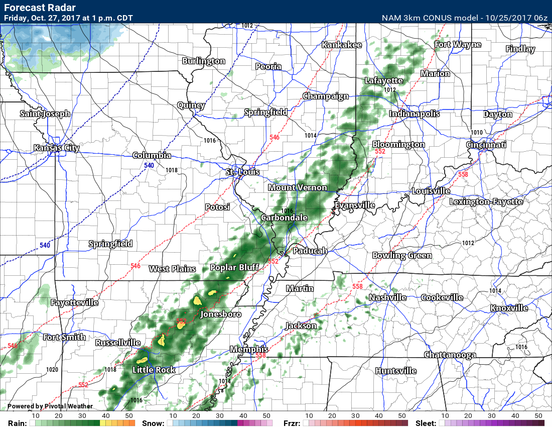
A strong cold front will sweep through the region on Friday. This front will be an ana-front. Ana-fronts have rain behind them vs in front of them.
The cold front will move from west to east during the daylight hours.
Rain will develop over Missouri and Illinois late Friday morning into the evening hours. The rain will be moving from west to east.
For now, I am forecasting a widespread 0.30″ to 0.60″ rain event. There could be heavier bands embedded in the system. Similar to recent rain events.
Temperatures on Friday should peak during the morning hours. Highs will likely be in the upper 50’s to lower 60’s. Temperatures will fall as the cold front moves through your area.
By evening, temperatures will likely have fallen into the upper 40’s to lower 50’s. Chilly rain, as well.
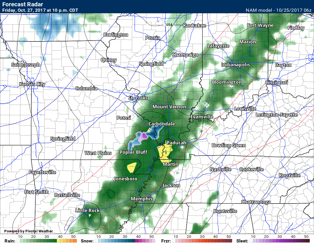
Rain will continue into Friday night/Saturday morning. Meanwhile, colder air will filter into the region from the northwest. Temperatures will likely fall into the 30’s by Saturday morning.
I can’t completely rule out the rain mixing with sleet or snow late Friday night/Saturday morning. This would be a novelty event with no real impact.
Clouds (low clouds) may linger well into Saturday. I would not be surprised if we remain cloudy into Saturday night. Lower confidence on Saturday cloud cover.
Both Saturday and Sunday will be chilly. Highs in the 40’s to lower 50’s. Overnight lows Sunday and Monday morning in the upper 20’s to lower 30’s with frost or freeze conditions likely.
Light rain or sleet pellet/snow flake could linger into Saturday. Keep that in mind. Colder air comes in. Clouds may remain. Sprinkles possible.
Let’s look at the future-cast radar for Friday.
This first image is for 1 pm Friday. You can see rain developing over the region.
This next image is for 7 pm Friday
This next image is for 1 am on Saturday. The blue and pink would be sleet/snow. No promises on that occurring. Just a novelty.
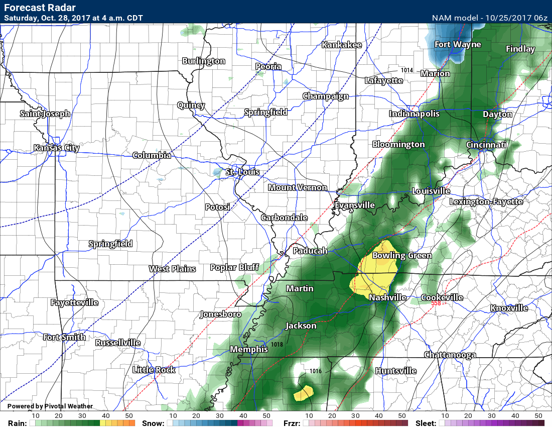
This next image is for 4 am on Saturday
Let me show you Friday’s temperatures.
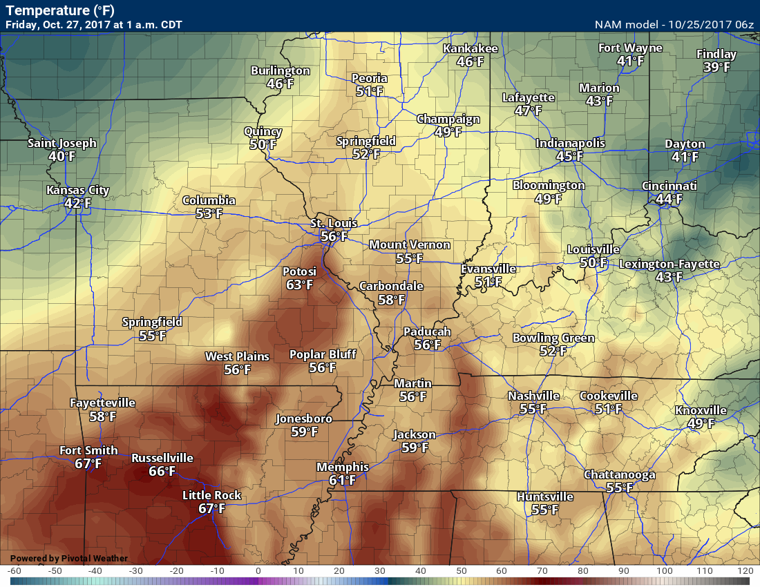
This first image is for 1 am on Friday. Notice how mild it is.
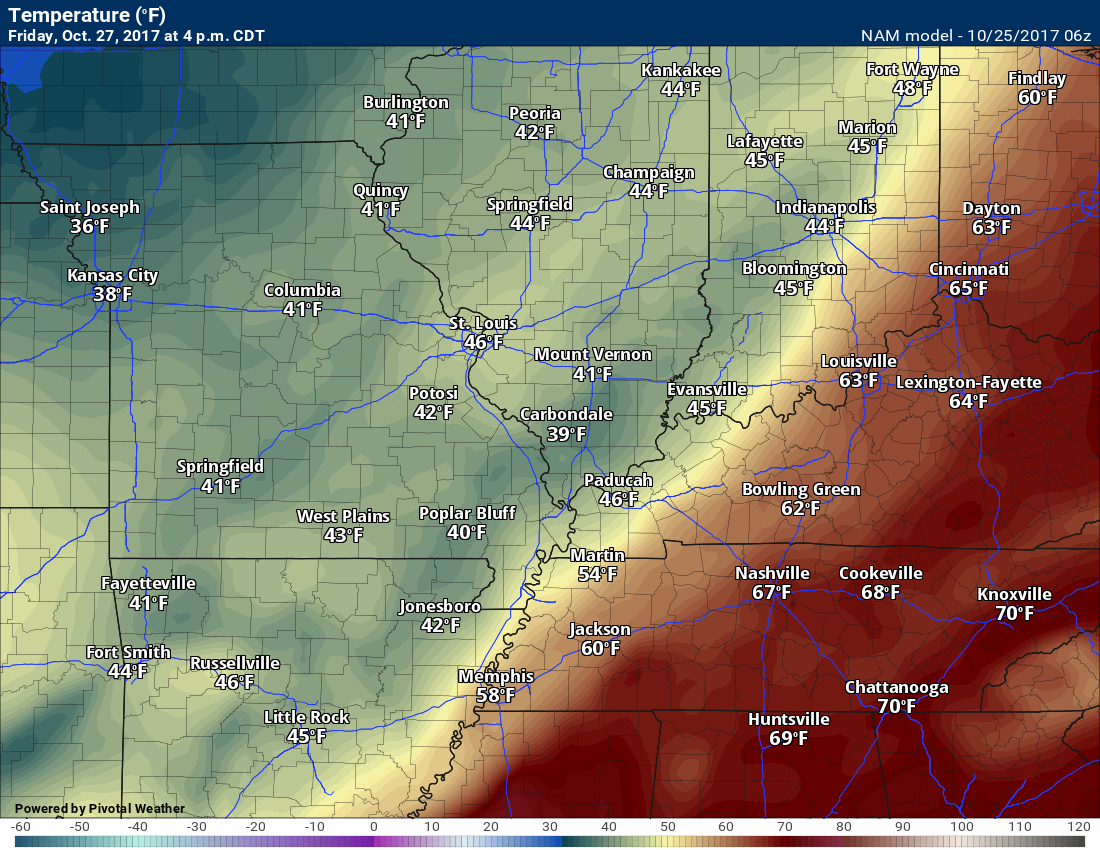
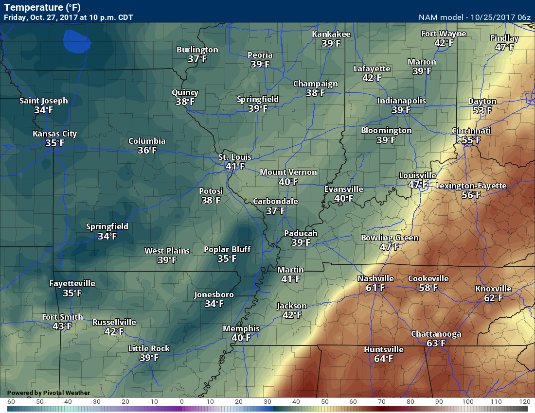
This next image is for 4 pm on Friday. Falling temperatures behind our cold front.
This image is for 10 pm on Friday. Temperatures continue to fall.
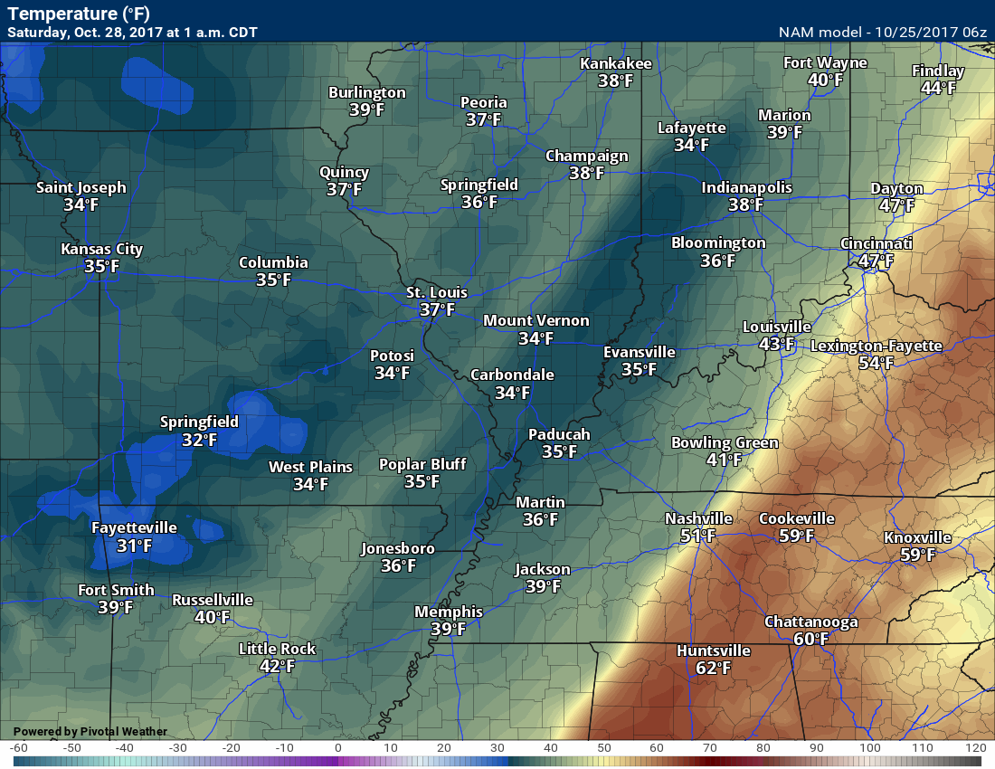
This next image is for 1 am on Saturday
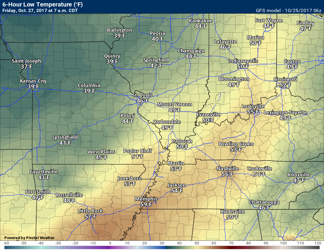
Temperature Forecast
Wednesday night low temperatures
Thursday high temperatures
Thursday night low temperatures
.
Are you subscribing to Weather Talk app/text messages and videos? This is what helps support all of the data you see each day.
We now offer premium videos for the short and long-range forecasts! These videos are produced by a team of long-range forecast experts. They are brought to you as bonus information. Activate text option four in order to receive these on your app or via text.
Subscribe at www.beaudodsonweather.com
We offer an Apple and Android app (scroll to the bottom of this page for more information).

Were you aware that I hired a team of meteorologists for long range videos?
To learn more, click this link
http://cms.weathertalk.com/meet-the-team/
.


We offer regional radars and local city radars – if a radar does not update then try another one. Occasional browsers need their cache cleared. You may also try restarting your browser. This will usually fix any problems.
During the winter you can track snow and ice by clicking the winterize button on the local city view interactive radars.
You may email me at beaudodson@usawx.com
Interactive Weather Radar Page. Choose the city nearest your location: Click this link
National interactive radar: Click this link.
The Beau Dodson Weather APP is ready for Apple and Android users. The app provides a faster way for you to receive my text messages. ATT and Verizon are not always reliable when it comes to speed.
Some of you have asked if you can receive the texts on your phone and the app. The answer to that is, yes. The Android app will automatically allow that to happen. On the Apple app, however, you will need to open your app and click the settings button. Make sure the green tab is OFF. Off means you will still receive the texts to your phone and the app. If you have any questions, then email me at beaudodson@usawx.com
The app is for text subscribers.
The direct download, for the Apple app, can be viewed here
https://itunes.apple.com/us/app/id1190136514
Here is the download link for the Android version Click Here
If you have not signed up for the texting service then you may do so at www.beaudodsonweather.com


——————————————————–
Your support helps with the following:

and

.

Whom do you trust for your weather information?
I have studied weather, in our region, since the late 1970’s. I have 40 years of experience in observing our regions weather patterns. My degree is in Broadcast Meteorology and a Bachelor’s of Science.
My resume includes:
Member of the American Meteorological Society.
NOAA Weather-Ready Nation Ambassador.
Meteorologist for McCracken County Emergency Management. I served from 2005 through 2015.
Meteorologist for McCracken County Rescue. 2015 through current
I own and operate the Southern Illinois Weather Observatory.
I am the chief meteorologist for Weather Talk LLC.
I am also a business owner in western Kentucky.
Recipient of the Mark Trail Award, WPSD Six Who Make A Difference Award, Kentucky Colonel, and the Caesar J. Fiamma” Award from the American Red Cross.
In 2005, I helped open the largest American Cross shelter in U.S. history. This was in Houston, Texas. I was deployed to help with the aftermath of Hurricane Katrina and Hurricane Rita. I was a shelter manager of one of the Houston, Texas shelter divisions.
In 2009 I was presented with the Kentucky Office of Highway Safety Award.
Recognized by the Kentucky House of Representatives for my service to the State of Kentucky leading up to several winter storms and severe weather outbreaks.
If you click on the image below you can read the Kentucky House of Representatives Resolution.

I am President of the Shadow Angel Foundation which serves portions of western Kentucky and southern Illinois.
There is a lot of noise on the internet. A lot of weather maps are posted without explanation. You need a trusted source for information.
My forecast philosophy is simple and straight forward.
- Communicate in simple terms
- To be as accurate as possible within a reasonable time frame before an event
- Interact with you on Twitter, Facebook, email, texts, and this blog
- Minimize the “hype” that you might see through other weather sources
- Push you towards utilizing wall-to-wall LOCAL TV coverage during severe weather events

Sign up for my AWARE email by clicking here.
I typically send AWARE emails before severe weather, winter storms, or other active weather situations. I do not email watches or warnings. The emails are a basic “heads up” concerning incoming weather conditions