WeatherTalk monthly operating costs can top $2000.00. Your $5 subscription helps pay for those costs. I work for you.
The $5 will allow you to register up to seven phones!
For $5 a month you can receive the following. You may choose to receive these via your WeatherTalk app or regular text messaging.
Severe weather app/text alerts from my keyboard to your app/cell phone. These are hand typed messages from me to you. During tornado outbreaks, you will receive numerous app/text messages telling you exactly where the tornado is located.
- Daily forecast app/texts from my computer to your app/cell phone.
- Social media links sent directly to your app/cell phone. When I update the blog, videos, or Facebook you will receive the link.
- AWARE emails. These emails keep you well ahead of the storm. They give you several days of lead time before significant weather events.
- Direct access to Beau via text and email. Your very own personal meteorologist. I work for you!
- Missouri and Ohio Valley centered video updates
- Long-range weather videos
- Week one, two, three and four temperature and precipitation outlooks.
Monthly outlooks. - Your subscription also will help support several local charities.
Would you like to subscribe? Subscribe at www.beaudodsonweather.com
Typical progression on a severe weather day for subscribers.


I encourage subscribers to use the app vs regular text messaging. We have found text messaging to be delayed during severe weather. The app typically will receive the messages instantly. I recommend people have three to four methods of receiving their severe weather information.
Remember, my app and text alerts are hand typed and not computer generated. You are being given my personal attention during significant weather events.

WWW.WEATHERTALK.COM subscribers, here is my day to day schedule for your weather products.
These are bonus videos and maps for subscribers. I bring these to you from the BAMwx team. I pay them to help with videos.
The Ohio and Missouri Valley videos cover most of our area. They do not have a specific Tennessee Valley forecast but may add one in the future.
The long-range video is technical. Over time, you can learn a lot about meteorology from the long range video. Just keep in mind, it is a bit more technical.


.
![]()

October 25, 2018
Thursday forecast: Cloudy. Cooler. Rain showers developing. Most of the rain will be light. Slightly more rain from the Missouri Bootheel into western Kentucky and northwest Tennessee vs areas further north (near the I64 corridor). Temperatures will be held down by the thickening clouds and precipitation.
Temperatures: MO ~ 50 to 55 IL ~ 50 to 55 KY ~ 52 to 56 TN ~ 53 to 56
What is the chance of precipitation? MO ~ 40% north and 70% south IL ~ 30% north of Carbondale and 60% south of Carbondale KY ~ 60% TN ~ 90%
Coverage of precipitation: Increasing coverage as we move through the day. Light precipitation, for the most part.
Wind: Northeast and east at 5 to 10 mph
What impacts are anticipated from the weather? Wet roadways.
My confidence in the forecast verifying: High
Is severe weather expected? No
The NWS defines severe weather as 58 mph wind or great, 1″ hail or larger, and/or tornadoes
Should I cancel my outdoor plans? Have a plan B, esp over southeast Missouri, far southern Illinois, far western Kentucky, and northwest Tennessee.
UV Index: 1 to 3 Low
Sunrise: 7:13 AM
Thursday Night Forecast Details:
Forecast: Cloudy. Rain likely. Cool temperatures.
Temperatures: MO ~ 40 to 45 IL ~ 40 to 45 KY ~ 42 to 46 TN ~ 42 to 46
What is the chance of precipitation? MO ~ 70% IL ~ 70% KY ~ 80% TN ~ 90%
Coverage of precipitation: Widespread
Frost Risk: None
Wind: North and northeast at 5 to 10 mph with gusts above 15 mph from the Missouri Bootheel into western Kentucky and Tennessee.
What impacts are anticipated from the weather? Wet roadways.
My confidence in the forecast verifying: High
Is severe weather expected? No
The NWS defines severe weather as 58 mph wind or great, 1″ hail or larger, and/or tornadoes
Should I cancel my outdoor plans? Have a plan B
Sunset: 6:05 PM
Moonrise: 7:09 PM Waning Gibbous
Moonset: 7:59 AM
October 26, 2018
Friday forecast: Cloudy. Damp. Cool. Patchy fog. Light rain and drizzle lingering through the morning and early afternoon hours. Rain ending southwest to northeast through the day. Breezy, this afternoon.
Temperatures: MO ~ 52 to 56 IL ~ 52 to 56 KY ~ 53 to 56 TN ~ 54 to 58
What is the chance of precipitation? MO ~ 60% before 12 pm and then decreasing to 20% after 5 pm IL ~ 60% before 1 pm and then decreasing to 20% after 5 pm KY ~ 60% before 1 pm and then decreasing to 20% after 4 pm TN ~ 60% during the morning and then 20% after 4 pm
Coverage of precipitation: Decreasing coverage as we move through the day. Ending from southwest to northeast.
Wind: Northwest at 6 to 12 mph with gusts to 18
What impacts are anticipated from the weather? Wet roadways
My confidence in the forecast verifying: High
Is severe weather expected? No
The NWS defines severe weather as 58 mph wind or great, 1″ hail or larger, and/or tornadoes
Should I cancel my outdoor plans? Have a plan B during the morning hours. Check radars in the afternoon (rain showers ending)
UV Index: 1 to 3 Low
Sunrise: 7:12 AM
Friday Night Forecast Details:
Forecast: A cloudy evening with a sprinkle or two. Cool temperatures. Patchy fog possible.
Temperatures: MO ~ 42 to 44 IL ~ 42 to 44 KY ~ 43 to 45 TN ~ 43 to 45
What is the chance of precipitation? MO ~ 10% IL ~ 10% KY ~ 20% TN ~ 20%
Coverage of precipitation: Rain should have ended. An evening shower possible over southeast Illinois and eastern portions of western Kentucky
Frost Risk: None
Wind: Northwest at 5 to 10 mph with evening gusts to 15 mph
What impacts are anticipated from the weather? Lower visibility if fog forms.
My confidence in the forecast verifying: Medium to high
Is severe weather expected? No
The NWS defines severe weather as 58 mph wind or great, 1″ hail or larger, and/or tornadoes
Should I cancel my outdoor plans? No, but it will be damp and a few sprinkles possible.
Sunset: 6:04 PM
Moonrise: 7:49 PM Waning Gibbous
Moonset: 9:04 AM
October 27, 2018
Saturday forecast: A mix of sun and clouds. A slight chance of an isolated light shower. Some clearing as the day progresses.
Temperatures: MO ~ 60 to 65 IL ~ 56 to 62 KY ~ 58 to 62 TN ~ 60 to 64
What is the chance of precipitation? MO ~ 10% IL ~ 10% KY ~ 10% TN ~ 10%
Coverage of precipitation: Isolated
Wind: West at 5 to 10 pm with gusts to 15 mph
What impacts are anticipated from the weather? Most likely none. Isolated wet road.
My confidence in the forecast verifying: High
Is severe weather expected? No
The NWS defines severe weather as 58 mph wind or great, 1″ hail or larger, and/or tornadoes
Should I cancel my outdoor plans? No
UV Index: 3 to 4 Moderate
Sunrise: 7:15 AM
Saturday Night Forecast Details:
Forecast: Clearing and cool. Patchy fog possible.
Temperatures: MO ~ 40 to 44 IL ~ 40 to 44 KY ~ 40 to 45 TN ~ 40 to 454
What is the chance of precipitation? MO ~ 0% IL ~ 0% KY ~ 0% TN ~ 0%
Coverage of precipitation: Most likely none.
Frost Risk: None
Wind: Northwest at 5 to 10 mph
What impacts are anticipated from the weather? Lower visibility where fog forms.
My confidence in the forecast verifying: High
Is severe weather expected? No
The NWS defines severe weather as 58 mph wind or great, 1″ hail or larger, and/or tornadoes
Should I cancel my outdoor plans? No
Sunset: 6:03 PM
Moonrise: 8:34 PM Waning Gibbous
Moonset: 10:11 AM
October 28, 2018
Sunday forecast: Partly sunny. An isolated shower over southeast Illinois and northwest Kentucky. Windy. Warmer.
Temperatures: MO ~ 66 to 70 IL ~ 63 to 66 KY ~ 64 to 68 TN ~ 66 to 68
What is the chance of precipitation? MO ~ 10% IL ~ 20% KY ~ 20% TN ~ 10%
Coverage of precipitation: None to isolated (mainly over our northeast counties)
Wind: West and southwest at 10 to 20 mph with gusts to 30 mph
What impacts are anticipated from the weather? Windy for area boaters. A couple of wet roadways possible (southeast IL and northwest KY)
My confidence in the forecast verifying: Medium
Is severe weather expected? No
The NWS defines severe weather as 58 mph wind or great, 1″ hail or larger, and/or tornadoes
Should I cancel my outdoor plans? No, but glance at radars
UV Index: 4 to 6 Moderate
Sunrise: 7:16 AM
Sunday Night Forecast Details:
Forecast: Clearing and chilly. Perhaps some patchy fog.
Temperatures: MO ~ 38 to 44 IL ~ 38 to 44 KY ~ 38 to 44 TN ~ 38 to 44
What is the chance of precipitation? MO ~ 0% IL ~ 0% KY ~ 0% TN ~ 0%
Coverage of precipitation: Most likely none.
Frost Risk: Wind conditions should help prevent frost.
Wind: West and northwest at 6 to 12 mph with higher gusts
What impacts are anticipated from the weather? Lower visibility where fog forms.
My confidence in the forecast verifying: Medium
Is severe weather expected? No
The NWS defines severe weather as 58 mph wind or great, 1″ hail or larger, and/or tornadoes
Should I cancel my outdoor plans? No
Sunset: 6:01 PM
Moonrise: 9:25 PM Waning Gibbous
Moonset: 11:15 AM
October 29, 2018
Monday forecast: Mostly sunny and mild.
Temperatures: MO ~ 60 to 65 IL ~ 60 to 65 KY ~ 60 to 65 TN ~ 60 to 65
What is the chance of precipitation? MO ~ 0% IL ~ 0% KY ~ 0% TN ~ 0%
Coverage of precipitation: None anticipated
Wind: West and northwest at 5 to 10 mph
What impacts are anticipated from the weather? Most likely none.
My confidence in the forecast verifying: Medium
Is severe weather expected? No
The NWS defines severe weather as 58 mph wind or great, 1″ hail or larger, and/or tornadoes
Should I cancel my outdoor plans? No
UV Index: 3 to 4 Moderate
Sunrise: 7:17 AM
Monday Night Forecast Details:
Forecast: Mostly clear.
Temperatures: MO ~ 40 to 44 IL ~ 38 to 44 KY ~ 40 to 44 TN ~ 40 to 44
What is the chance of precipitation? MO ~ 0% IL ~ 0% KY ~ 0% TN ~ 0%
Coverage of precipitation: Most likely none
Frost Risk: None
Wind: Winds becoming southerly at 5 to 10 mph
What impacts are anticipated from the weather? None
My confidence in the forecast verifying: Medium
Is severe weather expected? No
The NWS defines severe weather as 58 mph wind or great, 1″ hail or larger, and/or tornadoes
Should I cancel my outdoor plans? No
Sunset: 6:00 PM
Moonrise: 10:24 PM Waning Gibbous
Moonset: 12:17 PM
October 30, 2018
Tuesday forecast: Mostly sunny. Mild.
Temperatures: MO ~ 65 to 70 IL ~ 65 to 70 KY ~ 65 to 70 TN ~ 65 to 70
What is the chance of precipitation? MO ~ 0% IL ~ 0% KY ~ 0% TN ~ 0%
Coverage of precipitation: None anticipated
Wind: South at 5 to 10 mph with gusts to 15 mph
What impacts are anticipated from the weather? None.
My confidence in the forecast verifying: High
Is severe weather expected? No
The NWS defines severe weather as 58 mph wind or great, 1″ hail or larger, and/or tornadoes
Should I cancel my outdoor plans? No
UV Index: 4 to 6 moderate to high
Sunrise: 7:18 AM
Tuesday Night Forecast Details:
Forecast: Increasing clouds. A shower possible.
Temperatures: MO ~ 48 to 54 IL ~ 48 to 54 KY ~ 48 to 54 TN ~ 48 to 54
What is the chance of precipitation? MO ~ 20% IL ~ 20% KY ~ 20% TN ~ 20%
Coverage of precipitation: Perhaps scattered rain showers
Frost Risk: No
Wind: South at 7 to 14 mph with higher gusts
What impacts are anticipated from the weather? Wet roadways
My confidence in the forecast verifying: Low to medium
Is severe weather expected? No
The NWS defines severe weather as 58 mph wind or great, 1″ hail or larger, and/or tornadoes
Should I cancel my outdoor plans? No
Sunset: 5:59 PM
Moonrise: 10:24 PM Waning Gibbous
Moonset: 12:17 PM
October 31, 2018
Wednesday forecast: Mostly cloudy. An incoming cold front could mean rain. There is some discussion on the timing of the cold front. The bulk of rain could hold off until late Wednesday into Thursday. Monitor updates.
Temperatures: MO ~ 58 to 64 IL ~ 58 to 64 KY ~ 58 to 64 TN ~ 58 to 64
What is the chance of precipitation? MO ~ 30% IL ~ 30% KY ~ 30% TN ~ 30%
Coverage of precipitation: Monitor
Wind: South at 6 to 12 mph. Winds will shift behind the cold front and become west and northwest. The timing of the cold front is in question.
What impacts are anticipated from the weather? Wet roadways.
My confidence in the forecast verifying: LOW
Is severe weather expected? No
The NWS defines severe weather as 58 mph wind or great, 1″ hail or larger, and/or tornadoes
Should I cancel my outdoor plans? Monitor updates
UV Index: 3 to 4 Moderate
Sunrise: 7:19 AM
Wednesday Night Forecast Details:
Forecast: Cloudy. Showers possible.
Temperatures: MO ~ 40 to 45 IL ~ 40 to 45 KY ~ 40 to 45 TN ~ 40 to 45
What is the chance of precipitation? MO ~ 30% IL ~ 30% KY ~ 30% TN ~ 30%
Coverage of precipitation: Scattered
Frost Risk: None
Wind: West and northwest at 6 to 12 mph
What impacts are anticipated from the weather? Wet roadways.
My confidence in the forecast verifying: Medium
Is severe weather expected? No
The NWS defines severe weather as 58 mph wind or great, 1″ hail or larger, and/or tornadoes
Should I cancel my outdoor plans? Have a plan b and monitor updates
Sunset: 5:58 PM
Moonrise: 11:59 PM Waning Gibbous
Moonset: 2:03 PM
Learn more about the UV index readings. Click here.

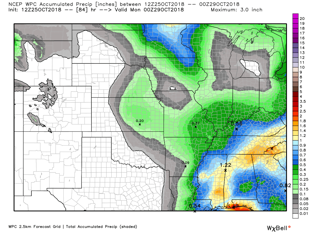
Here is the latest WPC/NOAA rainfall outlook.
The WPC has painted 0.20″ to 0.40″ across our local area.
This is now through Sunday evening.
Click to enlarge.
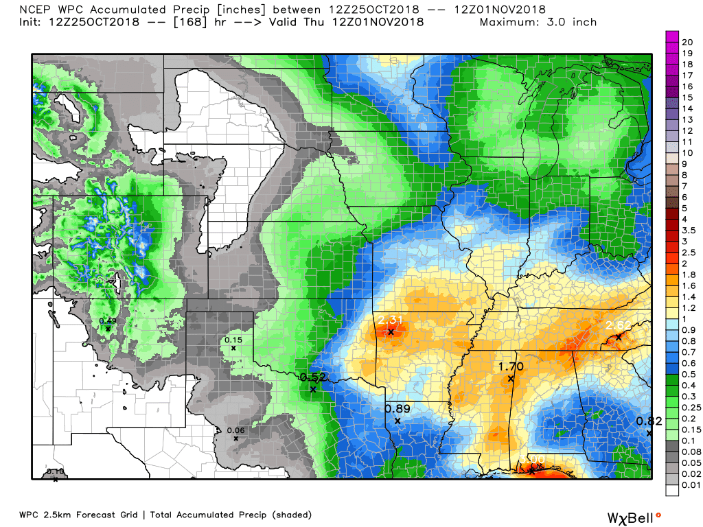
Extending out a bit more. This is the rain totals through next Thursday morning.
I am watching rain chances Wednesday/Thursday. That event is what pumps these numbers higher.
 .
.
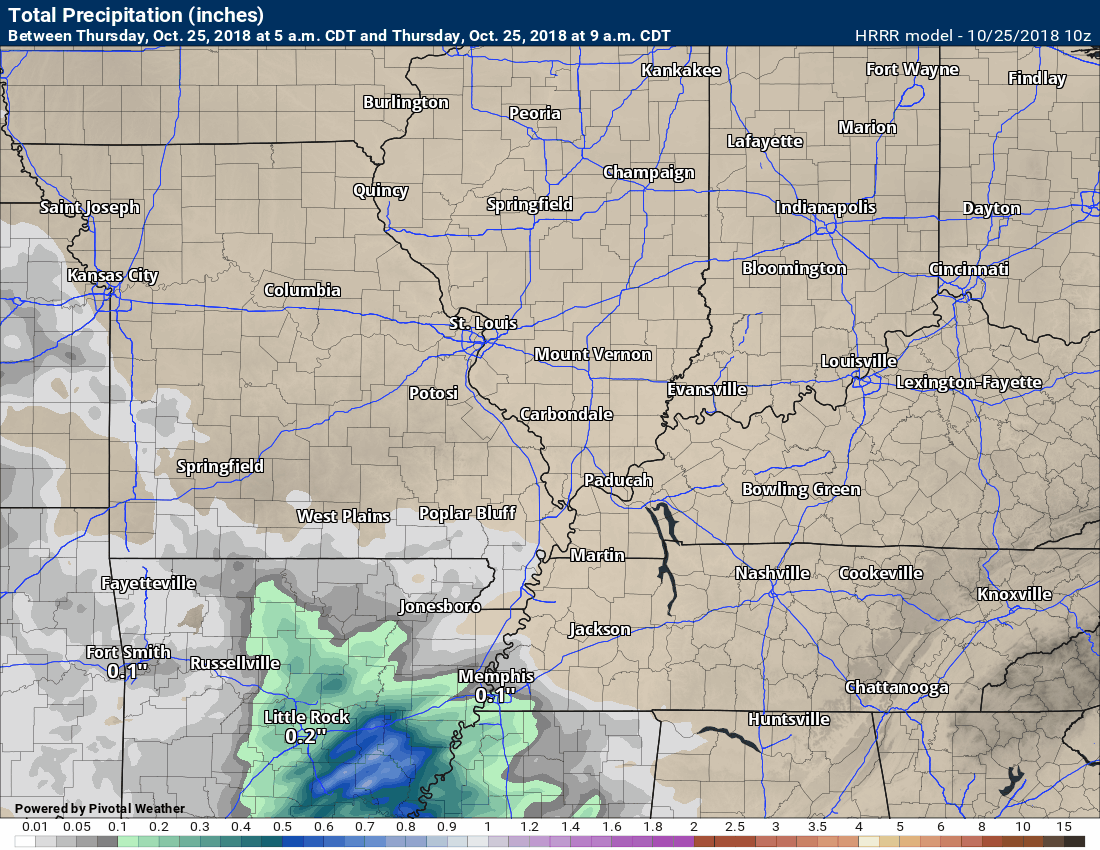
This next graphic is the short-range Hrrr model. It will only take us into 11 pm tonight.
Keep in mind, rain showers will arrive sooner than this model is showing totals. The reason for that is the totals are forecast to be so light.
This graphic is showing you rain totals.
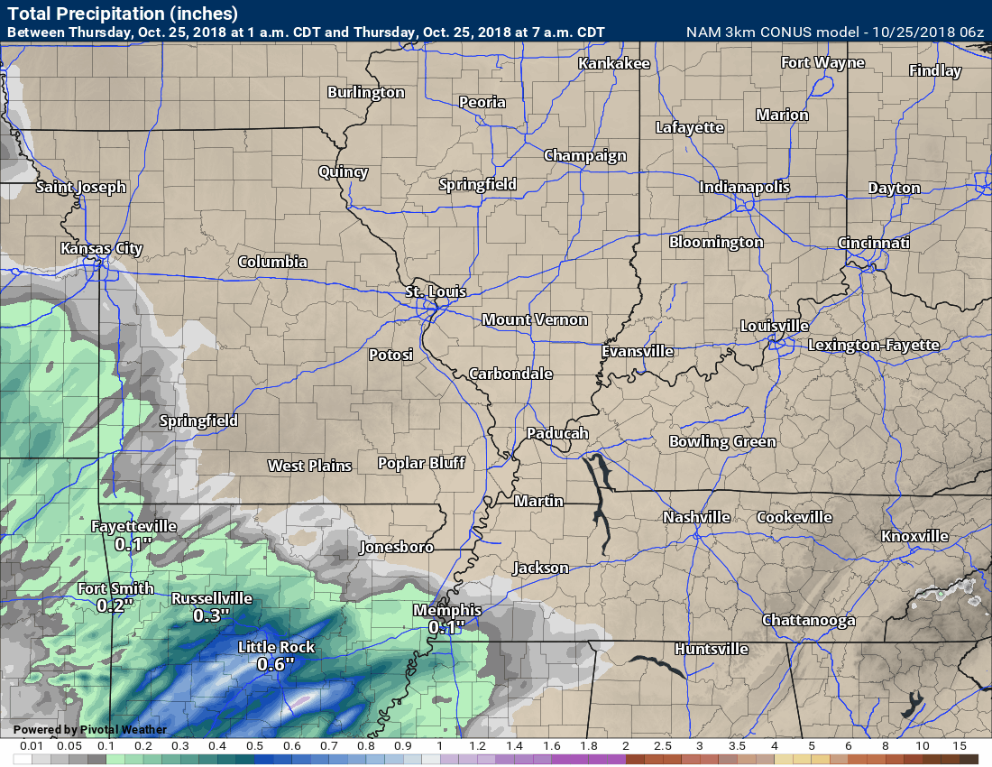
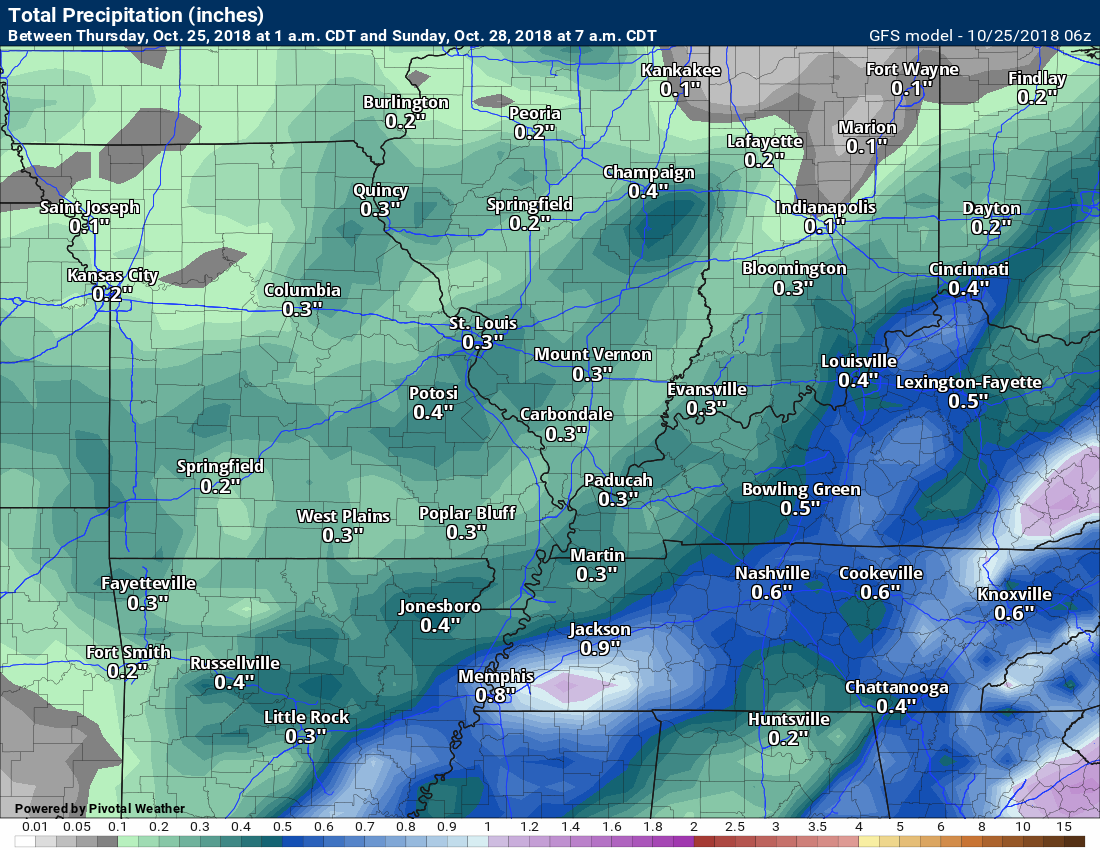
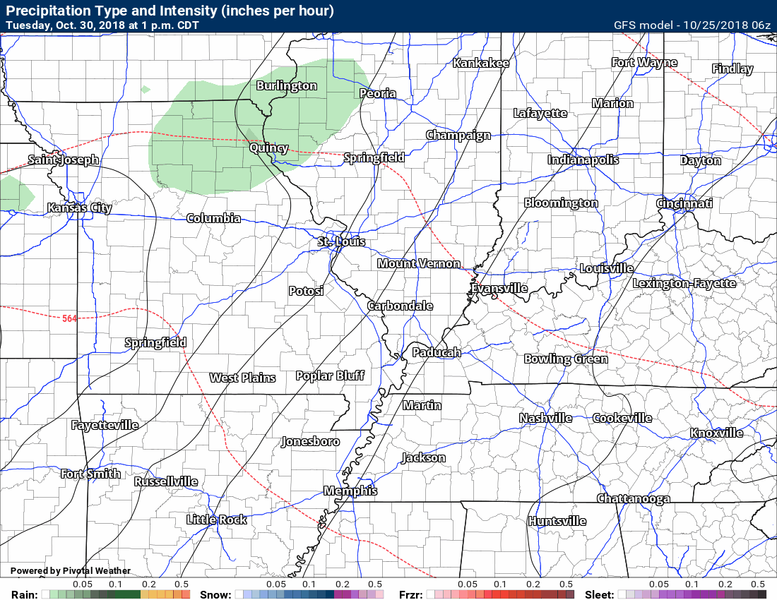
This next graphic is the NAM model guidance. This is a short range model.
The NAM is showing widespread 0.25″ to 0.50″. This would be through early Saturday afternoon. Most of the rain falls tomorrow into Friday.
Models are somewhat in agreement on radar totals.
This graphic is showing you rain totals.
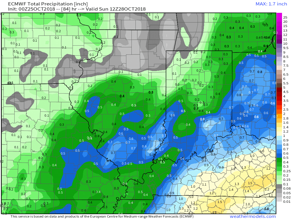
Here is another model. This is the GFS rainfall forecast through Sunday morning.
The GFS is bullish on 0.15″ to 0.35″.
Did you know that you can find me on Twitter?

Need a forecast for an outdoor event?


We offer interactive local city live radars and regional radars.
If a radar does not update then try another one. If a radar does not appear to be refreshing then hit Ctrl F5 on your keyboard.
You may also try restarting your browser. The local city view radars also have clickable warnings.
During the winter months, you can track snow and ice by clicking the winterize button on the local city view interactive radars.

Questions? Broken links? Other questions?
You may email me at beaudodson@usawx.com

The National Weather Service defines a severe thunderstorm as one that produces quarter size hail or larger, 58 mph winds or greater, and/or a tornado.
Today through next Thursday: Severe weather is not anticipated.
Interactive live weather radar page. Choose the city nearest your location. If one of the cities does not work then try a nearby one. Click here.
National map of weather watches and warnings. Click here.
Storm Prediction Center. Click here.
Weather Prediction Center. Click here.

Live lightning data: Click here.

Interactive GOES R satellite. Track clouds. Click here.

Here are the latest local river stage forecast numbers Click Here.
Here are the latest lake stage forecast numbers for Kentucky Lake and Lake Barkley Click Here.

- Rain and cool temperatures
- Monitoring another system around Halloween
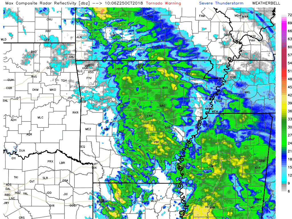
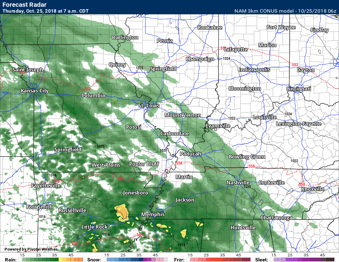
Here is the morning radar animation. This is what radar is actually showing (not a model).
You can see rain showers increasing over the area. Some of this may not be reaching the ground.
Most of this is fairly light. There are some heavier showers near the Missouri and Arkansas State line.
Click to enlarge.
View the live radars go here
We offer interactive local city view radars and regional radars.
If a radar does not update then try another one. If a radar does not appear to be refreshing then hit Ctrl F5. You may also try restarting your browser.
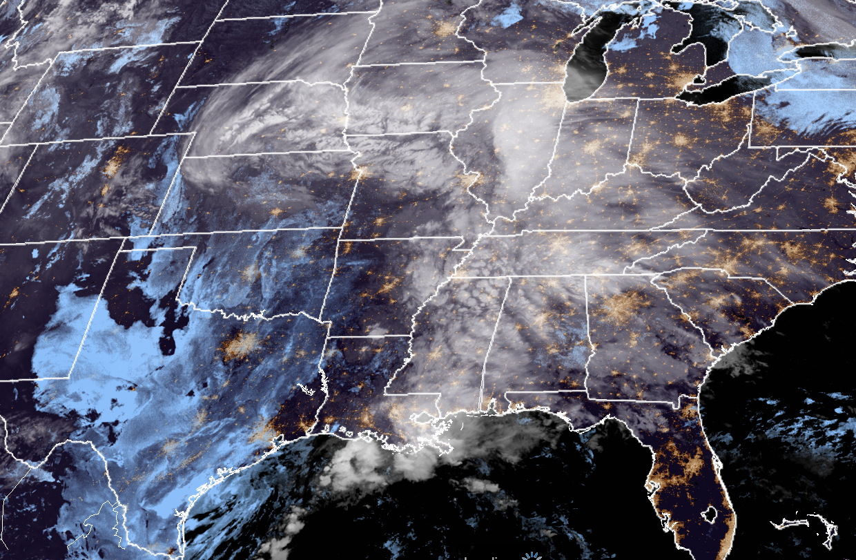
Morning satellite shows expansive clouds over the central United States.
Live satellite imagery. Be sure and hit refresh on the satellite page. Click here.
Here is the latest NAM model future-cast radar. This is what the NAM believes radar will look like into early Saturday morning.
We will have some rain showers on Friday, as well. The rain, however, should be diminishing during the morning hours. A few remaining showers are possible during the afternoon hours, but many areas will be drying out.
Any remaining rain will first end over southeast Missouri and then ending southwest to northeast across the region.
Those with Friday evening plans should plan on cool temperatures with clouds. Rain should have ended.
Friday night into Saturday night is expected to be mostly dry. I would not be surprised if there were a few light showers, but nothing significant.
Another weather maker dives into the region on Sunday. This will deliver a few more showers. Rain totals are expected to be light with that event, as well.
Those with outdoor plans on Sunday should check radars.
Our next rain maker should hold off until Wednesday and Thursday. Another widespread rain event is possible during that time-frame.
There remain some questions about whether or not the rain will arrive Wednesday vs Wednesday night/Thursday. Monitor updates.
The GFS is showing the rain on Wednesday.
Here is the GFS future-cast radar animation. This is for Wednesday.
Some doubt on the rains arrival time. Let’s watch Wednesday and Thursday.
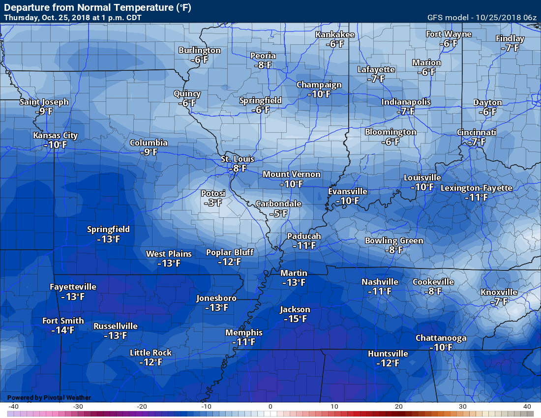
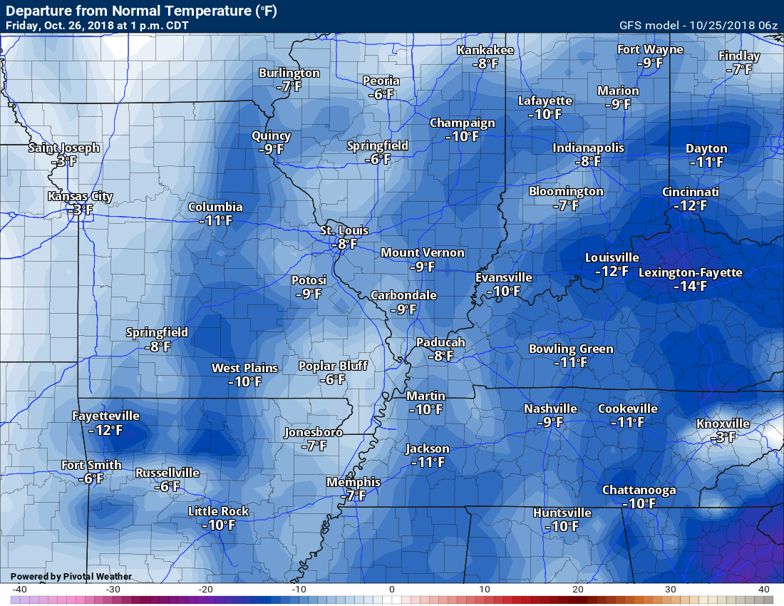
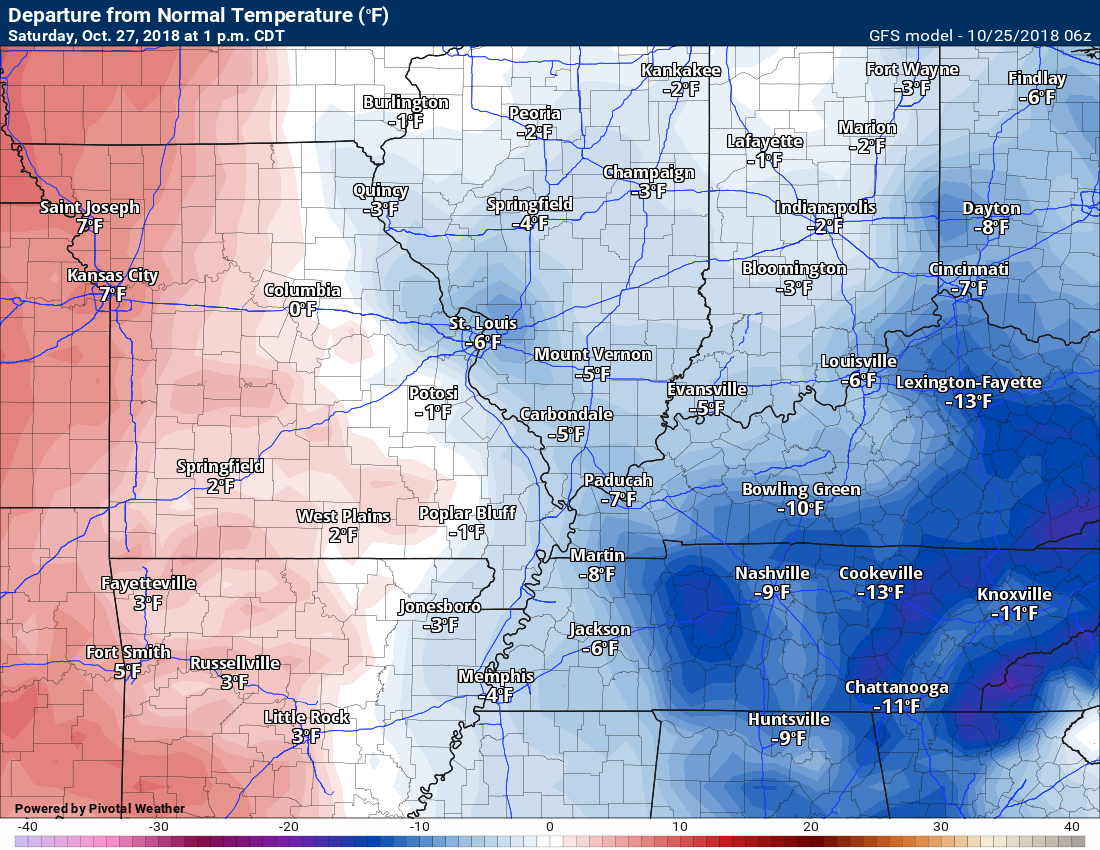
Temperatures through the next seven days will likely remain mostly below normal during the day. Cool weather.
Temperature anomalies over the next few days.
Normal high temperatures for this time of the year are around 70 degrees.
Normal low temperatures for this time of the year are around 45 degrees.
Today at 1 PM
These maps show you how many degrees above or below normal temperatures will be. Plenty of blue on this map.
Friday at 1 PM
Saturday at 1 PM
![]()
![]()

I bring these to you from the BAMwx team. They are excellent long-range forecasters.
Remember, long-range outlooks are a bit of skill, understanding weather patterns, and luck combined. It is not an exact science.

This product is for subscribers.
Subscribe at www.weathertalk.com
Subscriber graphics can be viewed on this page CLICK HERE

This product is for subscribers.

This product is for subscribers.
Subscribe at www.weathertalk.com
Subscriber graphics can be viewed on this page CLICK HERE
![]()
.
Fall Outlook!
Preliminary October precipitation outlook
.
Here is the preliminary November temperature and precipitation outlook
.
Preliminary November temperature outlook
Preliminary November precipitation outlook
.These products are for subscribers.
![]()

A new weather podcast is now available! Weather Geeks (which you might remember is on The Weather Channel each Sunday)
To learn more visit their website. Click here.
![]()

WeatherBrains Episode 666
This week’s Guest WeatherBrain is a world-renowned meteorologist, prognosticator, and extended outlook specialist. A 1978 graduate of Penn State University with a Bachelor of Science in Meteorology and former Nittany Lion Wrestler, he worked at AccuWeather soon after graduation. He currently works for WeatherBELL Analytics as co-Chief Forecaster. Joe Bastardi, welcome to WeatherBrains!
Other discussions in this weekly podcast include topics like:
Other discussions in this weekly podcast include topics like:
Hurricane Willa approaches the Mexican coast
Winter weather outlook from the panel
Astronomy Outlook with Tony Rice
and more!
Link to their website https://weatherbrains.com/
Previous episodes can be viewed by clicking here.

We offer interactive local city live radars and regional radars. If a radar does not update then try another one. If a radar does not appear to be refreshing then hit Ctrl F5. You may also try restarting your browser.
The local city view radars also have clickable warnings.
During the winter months, you can track snow and ice by clicking the winterize button on the local city view interactive radars.
You may email me at beaudodson@usawx.com
Find me on Facebook!

Find me on Twitter!

Did you know that a portion of your monthly subscription helps support local charity projects?
You can learn more about those projects by visiting the Shadow Angel Foundation website and the Beau Dodson News website.

I encourage subscribers to use the app vs regular text messaging. We have found text messaging to be delayed during severe weather. The app typically will receive the messages instantly. I recommend people have three to four methods of receiving their severe weather information.
Remember, my app and text alerts are hand typed and not computer generated. You are being given personal attention during significant weather events.
