WeatherTalk monthly operating costs can top $2000.00. Your $5 subscription helps pay for those costs. I work for you.
The $5 will allow you to register up to seven phones!
For $5 a month you can receive the following. You may choose to receive these via your WeatherTalk app or regular text messaging.
Severe weather app/text alerts from my keyboard to your app/cell phone. These are hand typed messages from me to you. During tornado outbreaks, you will receive numerous app/text messages telling you exactly where the tornado is located.
- Daily forecast app/texts from my computer to your app/cell phone.
- Social media links sent directly to your app/cell phone. When I update the blog, videos, or Facebook you will receive the link.
- AWARE emails. These emails keep you well ahead of the storm. They give you several days of lead time before significant weather events.
- Direct access to Beau via text and email. Your very own personal meteorologist. I work for you!
- Missouri and Ohio Valley centered video updates
- Long-range weather videos
- Week one, two, three and four temperature and precipitation outlooks.
Monthly outlooks. - Your subscription also will help support several local charities.
Would you like to subscribe? Subscribe at www.beaudodsonweather.com
Typical progression on a severe weather day for subscribers.


I encourage subscribers to use the app vs regular text messaging. We have found text messaging to be delayed during severe weather. The app typically will receive the messages instantly. I recommend people have three to four methods of receiving their severe weather information.
Remember, my app and text alerts are hand typed and not computer generated. You are being given my personal attention during significant weather events.

WWW.WEATHERTALK.COM subscribers, here is my day to day schedule for your weather products.
These are bonus videos and maps for subscribers. I bring these to you from the BAMwx team. I pay them to help with videos.
The Ohio and Missouri Valley videos cover most of our area. They do not have a specific Tennessee Valley forecast but may add one in the future.
The long-range video is technical. Over time, you can learn a lot about meteorology from the long range video. Just keep in mind, it is a bit more technical.


.
![]()

October 23, 2018
Tuesday forecast: Mostly sunny. Some high clouds from the Missouri Bootheel into western Kentucky. Elsewhere, there will be a few passing clouds. Mild for most of the region. A weak cold front will push into the northern counties. This will cool the air over our northern counties.
Temperatures: MO ~ 62 north to 68 south IL ~ 62 north and 64 to 66 south KY ~ 65 to 70 TN ~ 66 to 70
What is the chance of precipitation? MO ~ 0% IL ~ 0% KY ~ 0% TN ~ 0%
Coverage of precipitation: None
Wind: North and northeast at 5 to 10 mph with gusts to 15 mph
What impacts are anticipated from the weather? None
My confidence in the forecast verifying: High
Is severe weather expected? No
The NWS defines severe weather as 58 mph wind or great, 1″ hail or larger, and/or tornadoes
Should I cancel my outdoor plans? No
UV Index: 5 Moderate
Sunrise: 7:11 AM
Tuesday Night Forecast Details:
Forecast: Mostly clear. Chilly. Patchy fog and frost.
Temperatures: MO ~ 34 to 38 IL ~ 32 to 36 KY ~ 34 to 38 TN ~ 34 to 38
What is the chance of precipitation? MO ~ 0% IL ~ 0% KY ~ 0% TN ~ 0%
Coverage of precipitation: None
Frost Risk: Likely
Wind: North and northeast at 4 to 8 mph
What impacts are anticipated from the weather? Patchy fog possible.
My confidence in the forecast verifying: High
Is severe weather expected? No
The NWS defines severe weather as 58 mph wind or great, 1″ hail or larger, and/or tornadoes
Should I cancel my outdoor plans? No
Sunset: 6:08 PM
Moonrise: 6:02 PM Waxing Gibbous
Moonset: 5:54 AM
October 24, 2018
Wednesday forecast: Mostly sunny during the morning. Some increase in clouds through the day. Cooler.
Temperatures: MO ~ 56 to 62 IL ~ 58 to 62 KY ~ 58 to 64 TN ~ 58 to 64
What is the chance of precipitation? MO ~ 0% IL ~ 0% KY ~ 0% TN ~ 0%
Coverage of precipitation: None
Wind: Northeast at 5 to 10 mph with gusts to 15 mph
What impacts are anticipated from the weather? None
My confidence in the forecast verifying: High
Is severe weather expected? No
The NWS defines severe weather as 58 mph wind or great, 1″ hail or larger, and/or tornadoes
Should I cancel my outdoor plans? No
UV Index: 5 Moderate
Sunrise: 7:12 AM
Wednesday Night Forecast Details:
Forecast: Increasing clouds. Cool. Showers should hold off until Thursday. I will monitor trends.
Temperatures: MO ~ 38 to 44 IL ~ 38 to 44 KY ~ 40 to 45 TN ~ 42 to 46
What is the chance of precipitation? MO ~ 20% IL ~ 10% KY ~ 10% TN ~ 10%
Coverage of precipitation: Most likely none. I will monitor southeast Missouri after 3 AM. A few showers may approach from the southwest.
Frost Risk: No
Wind: East and northeast at 5 to 10 mph
What impacts are anticipated from the weather? Most likely none.
My confidence in the forecast verifying: High
Is severe weather expected? No
The NWS defines severe weather as 58 mph wind or great, 1″ hail or larger, and/or tornadoes
Should I cancel my outdoor plans? No
Sunset: 6:06 PM
Moonrise: 6:34 PM Full
Moonset: 6:56 AM
October 25, 2018
Thursday forecast: Cloudy. Cooler. A few showers (light) possible during the morning. More organized rain as we push into the afternoon and evening hours. Greatest rain coverage will be along and south of a line from Bollinger County, Missouri eastward to Pope County, Illinois.
Temperatures: MO ~ 50 to 55 IL ~ 50 to 55 KY ~ 52 to 56 TN ~ 53 to 56
What is the chance of precipitation? MO ~ 40% north and 60% south IL ~ 40% north of Carbondale and 40% to 50% south of Carbondale KY ~ 40% to 50% TN ~ 50% to 60%
Coverage of precipitation: Scattered during the morning. Coverage increase during the afternoon and evening.
Wind: Northeast and east at 5 to 10 mph
What impacts are anticipated from the weather? Wet roadways.
My confidence in the forecast verifying: Medium
Is severe weather expected? No
The NWS defines severe weather as 58 mph wind or great, 1″ hail or larger, and/or tornadoes
Should I cancel my outdoor plans? During the morning, no. During the afternoon I would recommend a plan B and monitor radars.
UV Index: 1 to 3 Moderate
Sunrise: 7:13 AM
Thursday Night Forecast Details:
Forecast: Mostly cloudy. Rain likely.
Temperatures: MO ~ 38 to 44 IL ~ 38 to 44 KY ~ 38 to 44 TN ~ 38 to 44
What is the chance of precipitation? MO ~ 70% IL ~ 70% KY ~ 70% TN ~ 70%
Coverage of precipitation: Widespread
Frost Risk: None
Wind: Northeast and east at 5 to 10 mph
What impacts are anticipated from the weather? Wet roadways.
My confidence in the forecast verifying: High
Is severe weather expected? No
The NWS defines severe weather as 58 mph wind or great, 1″ hail or larger, and/or tornadoes
Should I cancel my outdoor plans? Have a plan B
Sunset: 6:05 PM
Moonrise: 7:09 PM Waning Gibbous
Moonset: 7:59 AM
October 26, 2018
Friday forecast: Mostly cloudy. Showers are again possible. The greatest coverage will be during the morning hours. Decreasing coverage as we push towards evening.
Temperatures: MO ~ 52 to 56 IL ~ 52 to 56 KY ~ 53 to 56 TN ~ 54 to 58
What is the chance of precipitation? MO ~ 60% before 12 pm and then decreasing to 30% after 5 pm IL ~ 60% before 1 pm and then decreasing to 40% after 5 pm KY ~ 60% before 1 pm and then decreasing to 40% after 5 pm TN ~ 60% during the morning and then 40% after 5 pm
Coverage of precipitation: Numerous before noon and then decreasing activity through the day.
Wind: North at 6 to 12 mph with gusts to 18
What impacts are anticipated from the weather? Wet roadways
My confidence in the forecast verifying: Medium
Is severe weather expected? No
The NWS defines severe weather as 58 mph wind or great, 1″ hail or larger, and/or tornadoes
Should I cancel my outdoor plans? Have a plan B and monitor updates.
UV Index: 1 to 3 Low
Sunrise: 7:12 AM
Friday Night Forecast Details:
Forecast: Some clouds. Cool. Patchy fog. Rain should have ended.
Temperatures: MO ~ 36 to 44 IL ~ 36 to 44 KY ~ 38 to 44 TN ~ 38 to 44
What is the chance of precipitation? MO ~ 10% IL ~ 10% KY ~ 20% TN ~ 20%
Coverage of precipitation: Rain should have ended. An evening shower possible over southeast Illinois and eastern portions of western Kentucky
Frost Risk: None
Wind: North at 5 to 10 mph
What impacts are anticipated from the weather? Lower visibility if fog forms.
My confidence in the forecast verifying: Medium to high
Is severe weather expected? No
The NWS defines severe weather as 58 mph wind or great, 1″ hail or larger, and/or tornadoes
Should I cancel my outdoor plans? No
Sunset: 6:04 PM
Moonrise: 7:49 PM Waning Gibbous
Moonset: 9:04 AM
October 27, 2018
Saturday forecast: Mostly cloudy with a few scattered showers.
Temperatures: MO ~ 55 to 60 IL ~ 54 to 58 KY ~ 54 to 58 TN ~ 55 to 60
What is the chance of precipitation? MO ~ 30% IL ~ 30% KY ~ 20% to 30% TN ~ 30%
Coverage of precipitation: Widely scattered
Wind: Northwest at 5 to 10 pm
What impacts are anticipated from the weather? Wet roadways.
My confidence in the forecast verifying: Medium
Is severe weather expected? No
The NWS defines severe weather as 58 mph wind or great, 1″ hail or larger, and/or tornadoes
Should I cancel my outdoor plans? Monitor updates. Rain is possible.
UV Index: 2 Low
Sunrise: 7:15 AM
Saturday Night Forecast Details:
Forecast: Mostly cloudy. An isolated shower possible.
Temperatures: MO ~ 40 to 45 IL ~ 40 to 45 KY ~ 40 to 45 TN ~ 40 to 454
What is the chance of precipitation? MO ~ 20% IL ~ 20% KY ~ 20% TN ~ 20%
Coverage of precipitation: Isolated
Frost Risk: None
Wind: West and southwest at 5 to 10 mph
What impacts are anticipated from the weather? None to a few wet roadways
My confidence in the forecast verifying: Medium
Is severe weather expected? No
The NWS defines severe weather as 58 mph wind or great, 1″ hail or larger, and/or tornadoes
Should I cancel my outdoor plans? No
Sunset: 6:03 PM
Moonrise: 8:34 PM Waning Gibbous
Moonset: 10:11 AM
October 28, 2018
Sunday forecast: Quite a few clouds. Showers likely.
Temperatures: MO ~ 54 to 58 IL ~ 54 to 58 KY ~ 54 to 58 TN ~ 54 to 58
What is the chance of precipitation? MO ~ 50% IL ~ 50% KY ~ 50% TN ~ 50%
Coverage of precipitation: Scattered to perhaps numerous
Wind: West and southwest at 8 to 16 mph
What impacts are anticipated from the weather? Scattered wet roadways
My confidence in the forecast verifying: LOW
Is severe weather expected? No
The NWS defines severe weather as 58 mph wind or great, 1″ hail or larger, and/or tornadoes
Should I cancel my outdoor plans? No, but monitor updates and radars
UV Index: 3 to 4 Moderate
Sunrise: 7:16 AM
Sunday Night Forecast Details:
Forecast: Mostly clear and cool.
Temperatures: MO ~ 38 to 44 IL ~ 38 to 44 KY ~ 38 to 44 TN ~ 38 to 44
What is the chance of precipitation? MO ~ 20% IL ~ 30% KY ~ 30% TN ~ 20%
Coverage of precipitation: Widely scattered. Ending.
Frost Risk: Frost possible
Wind: Northwest at 6 to 12 mph with higher gusts
What impacts are anticipated from the weather? Perhaps a few wet roadways.
My confidence in the forecast verifying: Medium
Is severe weather expected? No
The NWS defines severe weather as 58 mph wind or great, 1″ hail or larger, and/or tornadoes
Should I cancel my outdoor plans? No
Sunset: 6:01 PM
Moonrise: 9:25 PM Waning Gibbous
Moonset: 11:15 AM
Learn more about the UV index readings. Click here.

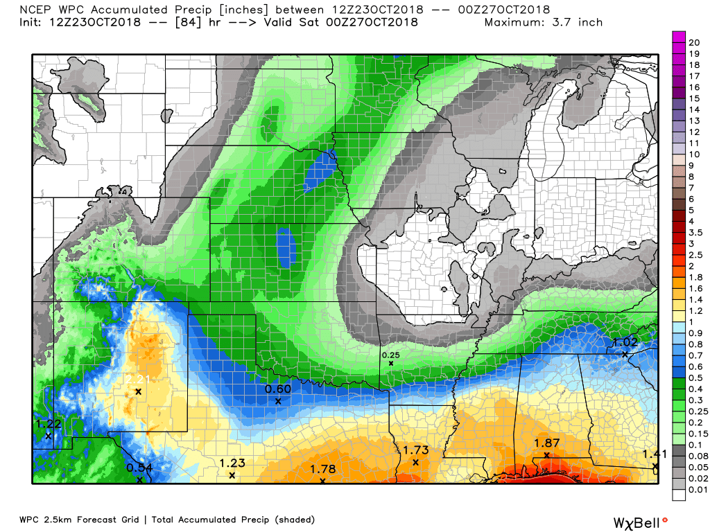
Here is the latest WPC/NOAA rainfall outlook.
Click to enlarge.
The weather will be dry today into Wednesday night.
Shower chances will begin to increase Thursday into Friday.
Another chance of scattered showers will arrive on Saturday and perhaps into Sunday.
Here are the WPC/NOAA rainfall forecast totals through Friday evening. Heavy rain is not anticipated. Light amounts.
This would occur on Thursday into Friday.
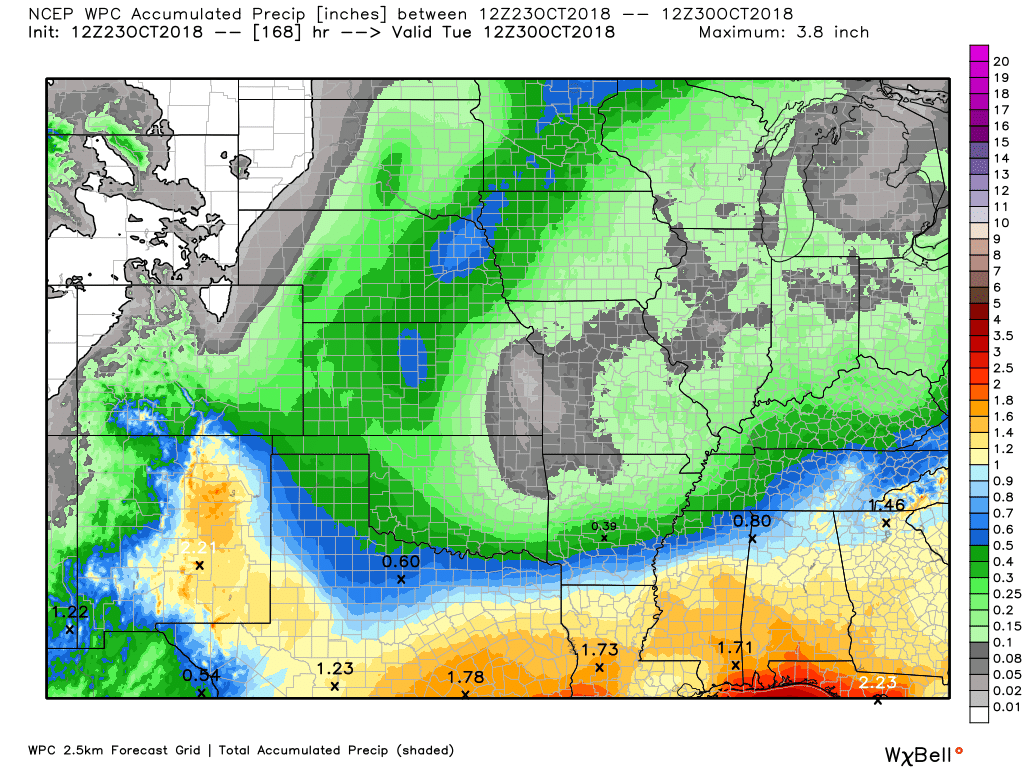
Here are the forecast rain totals through next Tuesday morning. This includes the above totals.
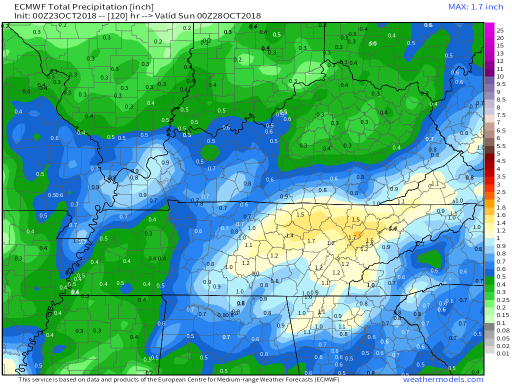
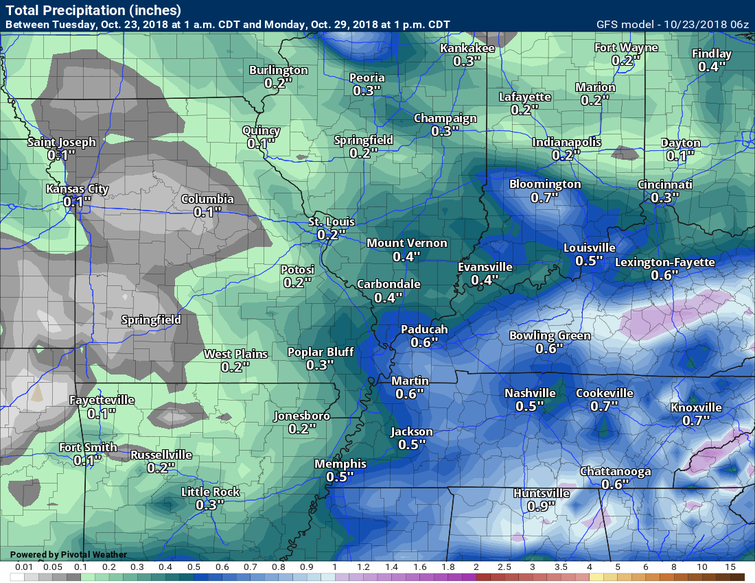
Here is another model. This is the GFS rainfall forecast.
This first graphic is through Friday night. The GFS is bullish on 0.10″ to 0.30″.
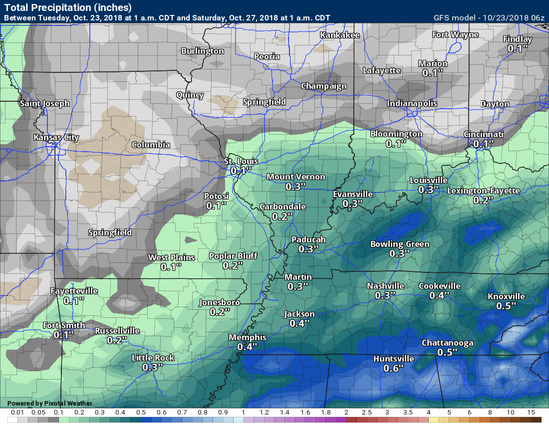
This next graphic is the GFS model through Monday afternoon. It is not too far off from the EC guidance.
Overall, it appears totals should remain below 0.30″ and then pockets of 0.40″ to 0.50″.
For now, I am a little skeptical of the heavier totals. With that said, there is quite a bit of moisture streaming northward out of the Gulf of Mexico. I will monitor trends in the guidance.
Severe weather is not a concern. That is the good news.
Did you know that you can find me on Twitter?

Need a forecast for an outdoor event?


We offer interactive local city live radars and regional radars.
If a radar does not update then try another one. If a radar does not appear to be refreshing then hit Ctrl F5 on your keyboard.
You may also try restarting your browser. The local city view radars also have clickable warnings.
During the winter months, you can track snow and ice by clicking the winterize button on the local city view interactive radars.

Questions? Broken links? Other questions?
You may email me at beaudodson@usawx.com

The National Weather Service defines a severe thunderstorm as one that produces quarter size hail or larger, 58 mph winds or greater, and/or a tornado.
Today through next Tuesday: Severe weather is not anticipated.
Interactive live weather radar page. Choose the city nearest your location. If one of the cities does not work then try a nearby one. Click here.
National map of weather watches and warnings. Click here.
Storm Prediction Center. Click here.
Weather Prediction Center. Click here.

Live lightning data: Click here.

Interactive GOES R satellite. Track clouds. Click here.

Here are the latest local river stage forecast numbers Click Here.
Here are the latest lake stage forecast numbers for Kentucky Lake and Lake Barkley Click Here.

- Quiet weather to continue into mid-week.
- Rain chances Thursday into the weekend.
We had a nice visit at the Metropolis, Illinois, Southern Seven Head Start Center. We did a walk through and discussed best practices for sheltering during severe weather.

A nice day is on tap for the region. We will have plenty of sunshine today. A few passing clouds.
A weak moisture-starved cold front is poised to dip into the region from the northwest. This front will simply help keep the overnight temperatures on the cool side.
Today will be mild with widespread 64 to 68-degree readings. This is near to below normal. With the sun, however, it will feel nice.
As the cold front dips into the area, we will have slightly cooler air move into our northern counties. Temperatures may fall a few degrees by late afternoon. This would mainly be north of Perry County, Missouri towards Carmi, Illinois.
A few clouds may accompany the front.
Chilly temperatures will be with us tonight. Frost is possible. Lows in the 30’s.
Dry weather will continue into Wednesday night.
Highs Wednesday will top out in the in the 56 to 62-degree range. A bit cooler than today. That will be because of the above mentioned cold front.
I am watching a series of rainmakers that will push into the region Thursday through Sunday.
The greatest chance of rain will be on Thursday and Friday. At one point it seemed the greatest risk would be on Saturday. Saturday may still have some showers, but coverage may not be as great.
The NAM is bullish on widespread light rain Thursday into Friday. There is some disagreement on coverage.
I would plan on some showers on the radar both Thursday and Friday.

A few showers are possible Saturday night and Sunday, as well.
You can expect a widespread 0.10″ to 0.30″ rain event. Pockets of higher totals possible. The higher totals would like be across the Missouri Bootheel into western Kentucky and northwest Tennessee. Those totals would range from 0.25″ to 0.50″. Whether we would push north of 0.50″ is questionable. I am monitoring trends in the guidance.
Both the EC and GFS models do show locally higher totals.
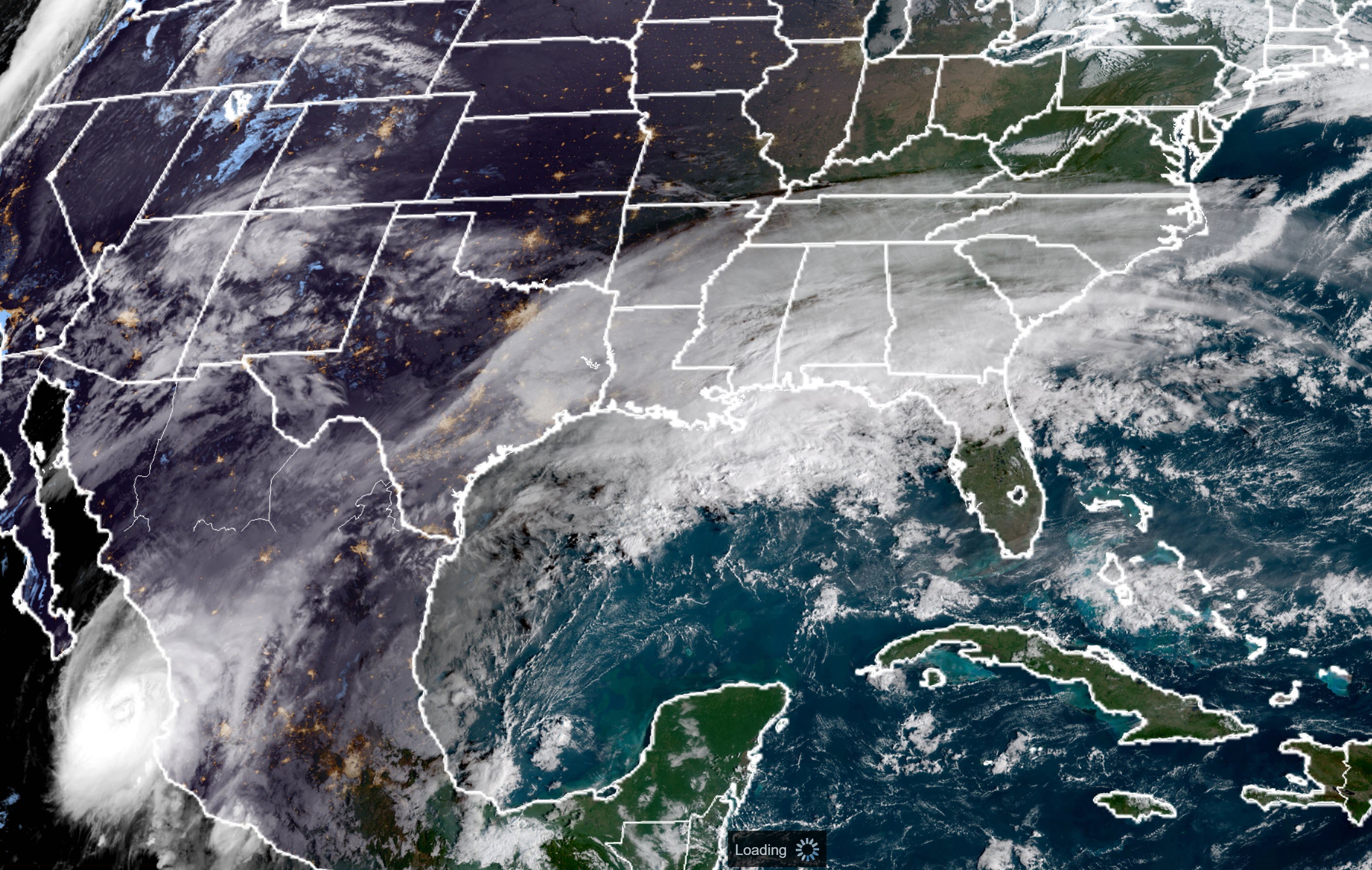
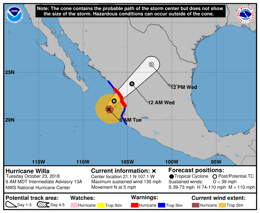
It is of interest that some of our clouds and moisture will be delivered from Hurricane Willa. Willa is located in the Pacific Ocean.
Here is the 8 AM visible satellite imagery. You can see Willa moving into Mexico. Notice the clouds stream northeast into the United States. A moisture feed.
Here is the track of Willa.
Below normal temperatures will continue into next week.
Temperatures were so far above normal, at the beginning of October, that our month to date anomalies continue to be skewed towards above average.
The last fourteen days, however, have been well below normal.
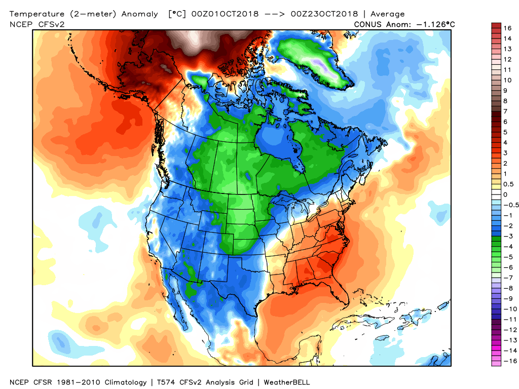
Here are the last fourteen days. These colors represent temperature anomalies. How many degrees above or below normal have temperatures been?
Click maps to enlarge (same as all graphics on this page).
![]()

I bring these to you from the BAMwx team. They are excellent long-range forecasters.
Remember, long-range outlooks are a bit of skill, understanding weather patterns, and luck combined. It is not an exact science.

This product is for subscribers.
Subscribe at www.weathertalk.com
Subscriber graphics can be viewed on this page CLICK HERE

This product is for subscribers.

This product is for subscribers.
Subscribe at www.weathertalk.com
Subscriber graphics can be viewed on this page CLICK HERE
![]()
.
Fall Outlook!
Preliminary October precipitation outlook
.
Here is the preliminary November temperature and precipitation outlook
.
Preliminary November temperature outlook
Preliminary November precipitation outlook
.These products are for subscribers.
![]()

A new weather podcast is now available! Weather Geeks (which you might remember is on The Weather Channel each Sunday)
To learn more visit their website. Click here.
![]()

WeatherBrains Episode 665
Tonight’s first guest is the Chief Meteorologist at WJHG-TV in Panama City, Florida. Chris Smith, welcome!
Also joining us is the Meteorologist in Charge at the NWS in Tallahassee, Florida. Tom Johnstone, welcome! In addition, Ginger Zee, the Chief Meteorologist at ABC News, offers her insight and her harrowing story at the coast.
Up next is weather photographer Doug Kiesling, who shared some amazing footage taken from the coast. Storm chaser Mark Sudduth also shares his story from where he rode out the storm in Panama City and Mexico Beach as well as discusses his GoPro video from Mexico Beach. Storm Chaser Brett Adair joins WeatherBrains and discusses his amazing and life-threatening story from Mexico Beach. The Former Director of the National Hurricane Center, Bill Read, also stops by and discusses Michael and it’s impact.
In addition, also joining us and adding to the all-star guest line-up is Bryan Norcross, Hurricane Specialist at WPLG-TV in Miami Florida. Phil Klotzbach from Colorado State University also drops by the show. Furthermore, Leslie Chapman-Henderson, President and CEO of the Federal Alliance for Safe Homes, as well as fellow FLASH associate and VP Mike Rimoldi, both stop by WeatherBrains.
Other discussions in this weekly podcast include topics like:
- Devastation along the Florida Gulf Coast after historic Hurricane Michael
- Discussion on Michael’s storm surge and historical comparisons
- Building code discussion along the Florida Gulf Coast
- Astronomy Outlook with Tony Rice
- and more!
Link to their website https://weatherbrains.com/
Previous episodes can be viewed by clicking here.

We offer interactive local city live radars and regional radars. If a radar does not update then try another one. If a radar does not appear to be refreshing then hit Ctrl F5. You may also try restarting your browser.
The local city view radars also have clickable warnings.
During the winter months, you can track snow and ice by clicking the winterize button on the local city view interactive radars.
You may email me at beaudodson@usawx.com
Find me on Facebook!

Find me on Twitter!

Did you know that a portion of your monthly subscription helps support local charity projects?
You can learn more about those projects by visiting the Shadow Angel Foundation website and the Beau Dodson News website.

I encourage subscribers to use the app vs regular text messaging. We have found text messaging to be delayed during severe weather. The app typically will receive the messages instantly. I recommend people have three to four methods of receiving their severe weather information.
Remember, my app and text alerts are hand typed and not computer generated. You are being given personal attention during significant weather events.
