

.
A Weather Talk subscription ($3 a month) is required to view the videos. This helps cover monthly costs (which can run between one and two thousand dollars).
Videos are posted on the www.weathertalk.com website. Once there, click the Beau Video-Cast tab. Long Range Video Update
If you believe you missed a video then you may check the LIVE FEED link on the Weather Talk website. You will find an archive of videos on that page.
You can also receive the videos via your Weather Talk app/text messages. Turn text option FOUR to the on position. The Weather Extra text option. Sign up for the app/text messages, videos, and more at www.beaudodsonweather.com
.
This forecast covers the counties in red. The counties in orange are covered by the forecast discussion further down in the blog.


.
October 21, 2017
Saturday Night Forecast Details:
Forecast: Becoming mostly cloudy. Mild. Breezy. A few scattered showers before midnight. Increasing chances of showers after 3 am for southeast Missouri and southwest Illinois. A thunderstorm possible for southeast Missouri and southwest Illinois. Widespread rain developing west of the Mississippi River in the wee hours of the morning. A few heavy downpours possible west of the Mississippi River after 3 am.
Temperatures: MO ~ 64 to 70 IL ~ 64 to 68 KY ~ 64 to 68
Winds: South winds 10 to 20 mph with gusts to 25 mph
What impacts are anticipated from the weather? Lightning. Wet roadways possible after midnight.
My confidence in the forecast verifying: Medium
Is severe weather expected? Unlikely. A small risk for a stronger storm over southeast Missouri. Damaging winds would be the primary concern. The main concern would be Butler County, MO and then westward from there.
The NWS defines severe weather as 58 mph winds or great, 1″ hail or larger, and/or tornadoes
What is the chance of precipitation? MO ~ 80% (mainly late) SW IL ~ 60% SE IL ~ 30% KY ~ 30%
Coverage of precipitation: Some scattered showers before midnight. Increasing coverage late. Numerous showers and perhaps thunderstorms after 3 am for southeast Missouri and southwest Illinois.
Should I cancel my outdoor plans? No, but check radars.
.
October 22, 2017
Sunday Forecast Details
Forecast: Mostly cloudy. Breezy at times. Widespread showers and thunderstorms along and west of a line from Jefferson County, Illinois, south to Alexander County, Illinois, and then south to the Missouri Bootheel. Locally heavy rain possible over southeast Missouri and southwest Illinois. Activity will spread east of the Mississippi River, but will likely weaken. Rainfall totals up to 3 pm on Sunday should be less east of the MS River vs west. Keep that in mind. The Pennyrile area of western Kentucky would likely receive the least coverage vs areas further west.
Activity will redevelop during the afternoon and spread in from the S/SW to the N/NE.
Temperatures: MO ~ 73 to 76 IL ~ 73 to 76 KY ~ 73 to 76
Winds: South and southwest at 10 to 20 mph. Higher gusts possible.
What impacts are anticipated from the weather? Lightning and wet roadways. Locally heavy rain for southeast Missouri.
My confidence in the forecast verifying: Medium
Is severe weather expected? Small risk for strong storms during the morning hours. Monitor updates.
The NWS defines severe weather as 58 mph winds or great, 1″ hail or larger, and/or tornadoes
What is the chance of precipitation? MO ~ 70% SW IL ~ 70% SE IL ~ 70% KY ~ 70%
Coverage of precipitation: Numerous for southeast Missouri and southwest Illinois. Scattered to numerous east of the Mississippi River.
Should I cancel my outdoor plans? Monitor updates and have a plan B.
.
Sunday Night Forecast Details:
Forecast: Cloudy. Rain redeveloping from the south and southwest. Rain will move north/northeast. The track of the Sunday night system is being monitored. Confidence on the exact track is low to medium. The track is key to who receives additional rain from Sunday night into Monday. Best chances will be east of the Mississippi River vs west.
Temperatures: MO ~ 50 to 55 IL ~ 50 to 55 KY ~ 54 to 58
Winds: Variable winds at 6 to 12 mph. Gusty winds possible from time to time.
What impacts are anticipated from the weather? Wet roadways. Lightning possible.
My confidence in the forecast verifying: Low
Is severe weather expected? No
The NWS defines severe weather as 58 mph winds or great, 1″ hail or larger, and/or tornadoes
What is the chance of precipitation? MO ~ 50% IL ~ 70% KY ~ 70%
Coverage of precipitation: Scattered to perhaps numerous.
Should I cancel my outdoor plans? Have a plan B.
.
October 23, 2017
Monday Forecast Details
Forecast: Cloudy. Cooler. Rain showers possible, especially over southern Illinois and Kentucky. Temperatures will vary based on cloud cover. Areas with thicker clouds will likely remain in the 50’s. Some question on the second storm systems track.
Temperatures: MO ~ 62 to 66 IL ~ 58 to 64 KY ~ 58 to 64
Winds: Northwest at 6 to 12 mph with gusts to 20 mph.
What impacts are anticipated from the weather? Wet roadways.
My confidence in the forecast verifying: LOW
Is severe weather expected? No
The NWS defines severe weather as 58 mph winds or great, 1″ hail or larger, and/or tornadoes
What is the chance of precipitation? MO ~ 40% IL ~ 50% KY ~ 60%
Coverage of precipitation: Scattered to perhaps numerous east of the Mississippi River.
Should I cancel my outdoor plans? Have a plan B, especially Illinois and Kentucky.
.
Monday Night Forecast Details:
Forecast: Cloudy. A shower possible. Cooler.
Temperatures: MO ~ 45 to 50 IL ~ 45 to 50 KY ~ 45 to 50
Winds: Northwest winds at 5 to 10 mph with gusts to 15 mph.
What impacts are anticipated from the weather? Wet roadways.
My confidence in the forecast verifying: Medium
Is severe weather expected? No
The NWS defines severe weather as 58 mph winds or great, 1″ hail or larger, and/or tornadoes
What is the chance of precipitation? MO ~ 20% IL ~ 30% KY ~ 30%
Coverage of precipitation: Spotty.
Should I cancel my outdoor plans? Monitor updates
.
October 24, 2017
Tuesday Forecast Details
Forecast: Breezy. Mostly cloudy early in the day. A chance of a few showers. Cooler.
Temperatures: MO ~ 55 to 60 IL ~ 55 to 60 KY ~ 55 to 60
Winds: West and northwest at 10 to 20 mph with higher gusts.
What impacts are anticipated from the weather? Perhaps wet roadways
My confidence in the forecast verifying: LOW
Is severe weather expected? No
The NWS defines severe weather as 58 mph winds or great, 1″ hail or larger, and/or tornadoes
What is the chance of precipitation? MO ~ 20% IL ~ 30% KY ~ 30%
Coverage of precipitation: Isolated to spotty.
Should I cancel my outdoor plans? Monitor updates.
.
Tuesday Night Forecast Details:
Forecast: Partly cloudy. Colder.
Temperatures: MO ~ 38 to 44 IL ~ 38 to 44 KY ~ 38 to 44
Winds: Northwest winds at 4 to 8 mph
What impacts are anticipated from the weather? Patchy fog possible.
My confidence in the forecast verifying: Medium
Is severe weather expected? No
The NWS defines severe weather as 58 mph winds or great, 1″ hail or larger, and/or tornadoes
What is the chance of precipitation? MO ~ 10% IL ~ 10% KY ~ 10%
Coverage of precipitation: Most likely none
Should I cancel my outdoor plans? No

The National Weather Service definition of a severe thunderstorm is one that produces quarter size hail or larger, 58 mph winds or greater, and/or a tornado.
Saturday night through Monday: Lightning is possible during this time period. There is a low-end risk for high winds on Saturday night/Sunday morning over southeast Missouri as a squall line enters the region. The line will be weakening as it moves east. Severe risk is minimal, at best.
If severe weather were to occur it would be from Butler County, Missouri, northward towards Iron County and then west of that line.
Tuesday through Thursday: Severe weather is not anticipated.
Friday through Sunday: I am monitoring another cold front on Friday/Friday night. The speed of the front is questionable. Thunderstorms will be possible along the front.

Weather Highlights:
Beau’s Saturday Morning Weather Update
Additional radars, graphics, and links will be posted in the comment section.
Highlights
1. Warm today. Becoming breezy. A few fast moving light showers.
2. Clouds thicken and lower tonight. Winds pick up and gust well into the 20’s. Rain chances ramp up, especially west of the Mississippi River.
3. We will have rain chances Sunday into Tuesday. Two distinct systems.
4. Several cold shots in the charts the next couple of weeks.
5. Frost or freeze risks next week? A couple of chances.
Saturday night video update
Forecast:
Saturday night
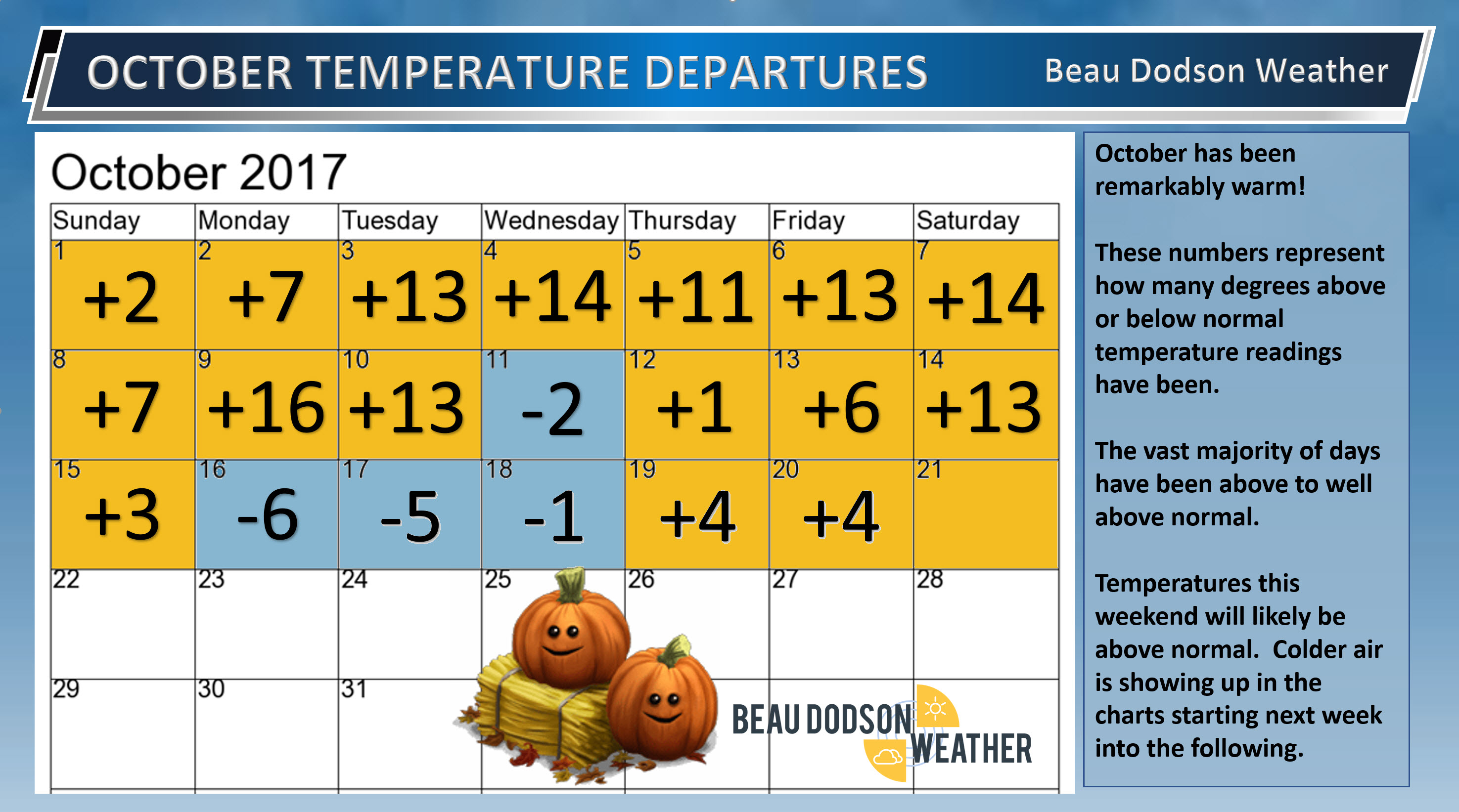
It was another warm day across the region. Highs ranged from the upper 70’s to around 80 degrees. Quite amazing.
Check out the October anomalies. This graphic shows you how many days have been above or below normal and how many degrees above or below normal.
A cold front slowly moves out of the central United States. This front will produce a band of widespread heavy showers and thunderstorms from Texas to Iowa. You will likely see a solid band of rain on the radar to our west.
This band of showers and storms will slowly move eastward and rain chances will increase to 80% after 2 or 3 am for southeast Missouri and perhaps southwest Illinois.
Let’s draw a line from the Bootheel of Missouri to Cairo, Illinois to Mt Vernon, Illinois. Along and west of that line will have the best chance of organized showers and storms during the wee hours of the morning hours. Areas to the east will have lesser chances.
The severe weather risk tonight is small. I can’t completely rule out some high winds with the storms as they first enter southeast Missouri (Poplar Bluff area). Storms will weaken with time.
Tonight you may see some severe weather watches for western Missouri and perhaps a little bit east of there.
Sunday
Forecast confidence drops a bit on Sunday. Complicated setup and I am glad this isn’t a winter storm.
The cold front will stall. This will mean the eastward progression of the solid band of showers and thunderstorms will slow. It will also weaken them.
Where it slows and weakens is the key to how much rain falls from sunrise tomorrow until the afternoon hours. This is especially true for southeast Illinois and the Pennrile area of western Kentucky.
A second system is going to develop Sunday and Sunday night to our south. This second area of low pressure is what will slow the eastward progression of the cold front.
There is little to no agreement in the model guidance as to how Sunday’s forecast pans out. That leaves it up to me to make the forecast.
These are my thoughts.
Plan on rain tomorrow. Have a plan B for outdoor activities.
I am certain that southeast Missouri and southwest Illinois will be dealing with numerous showers and thunderstorms. Most likely far western Kentucky, as well. Far western Kentucky would include the far most six counties.
Southeast Illinois and the rest of western Kentucky will likely have some showers, but coverage may not be as great as areas to the west.
The heaviest rain totals tonight into Sunday afternoon will be over southeast Missouri and southwest Illinois. These areas should pick up 0.50″ to 0.90″. Thunderstorms could produce higher totals.
The far western six counties of Kentucky, southeast Illinois, and northwest Tennessee will likely pick up 0.10″ to 0.30″ from sunrise until 3 pm Sunday. Areas to the east of there perhaps less.
System number two.
A winter type storm system will develop Sunday afternoon and night to our south. This would be a classic winter storm setup for our region (if it were December, January, or February).
Obviously, it will be too warm for snow.
Rain showers and some thunderstorms will redevelop and spread north-northeast from Arkansas and Tennessee late Sunday afternoon into Monday.
This second event may cover western Tennessee, western Kentucky, and southeast Illinois with rain. That is where the highest rain coverage and intensity should be.
Southeast Missouri and southwest Illinois may have rain showers from system two, as well. The coverage, however, won’t be as great as areas to the east.
Rain chances Sunday night into Monday will be greater than 70% for southeast Illinois, western Kentucky, and northwest Tennessee. Rain chances west of there will be 60% or less.
ANY shift in the second storm systems path will completely change the forecast. Just like in winter, the storm track is key to rainfall totals Sunday night into Monday.
Monday night into Tuesday
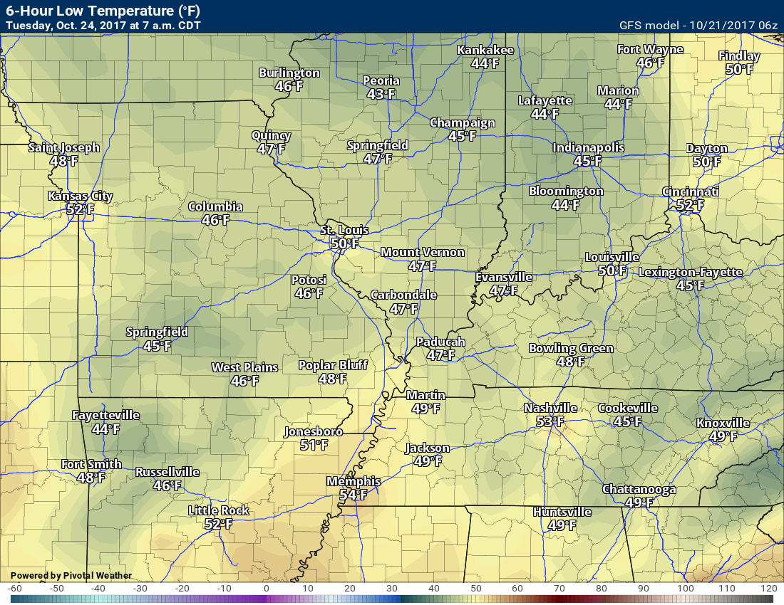
Cooler air will filter into the region beginning Sunday afternoon and night. The colder air will be reinforced on Monday into Tuesday. As a matter of fact, temperatures on Tuesday may remain in the 50’s for daytime highs.
Frost is possible Tuesday night/Wednesday. The confidence on frost occurring is low. I will need to see if clouds clear out and winds subside. For now, I have temperatures dipping into the upper 30’s and lower 40’s. Adjustments may need to be made in future updates.
Friday/Saturday
Even colder air arrives behind a cold front on Friday and Friday night. That could mean frost of freeze conditions by the weekend.
Rain is likely again Friday and perhaps a portion of the weekend.
As always the GFS guidance is likely too fast in moving that cold front through the area. The EC model guidance is likely too slow. I have rain chances in the Friday/Friday night forecast.
Saturday and Sunday will need to be monitored. The speed of the front is key to the weekend weather.
Much colder air is forecast to arrive behind the weekend cold front. As a matter of fact, it may be the coldest air of the season, thus far. Frost or freeze conditions will be possible.
Here is the NAM model for Saturday night into Sunday.
Notice how the band of showers and heavy thunderstorms weakens as it moves into our area.
Also, notice the second area of rain with system number two on Sunday afternoon into Monday.
This is the future-cast radar from the NAM guidance. This is what radar might look like over the next 48 hours.
Click to enlarge. Time stamp in the upper right portion of the animation.
Rainfall totals from the NAM guidance. Again, notice the sharp differences from west to east.
Temperature Forecast
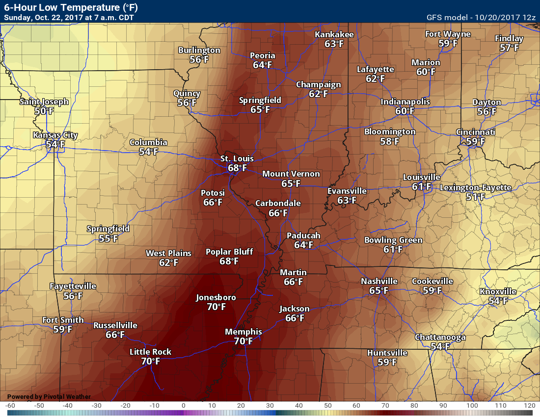
Saturday night lows
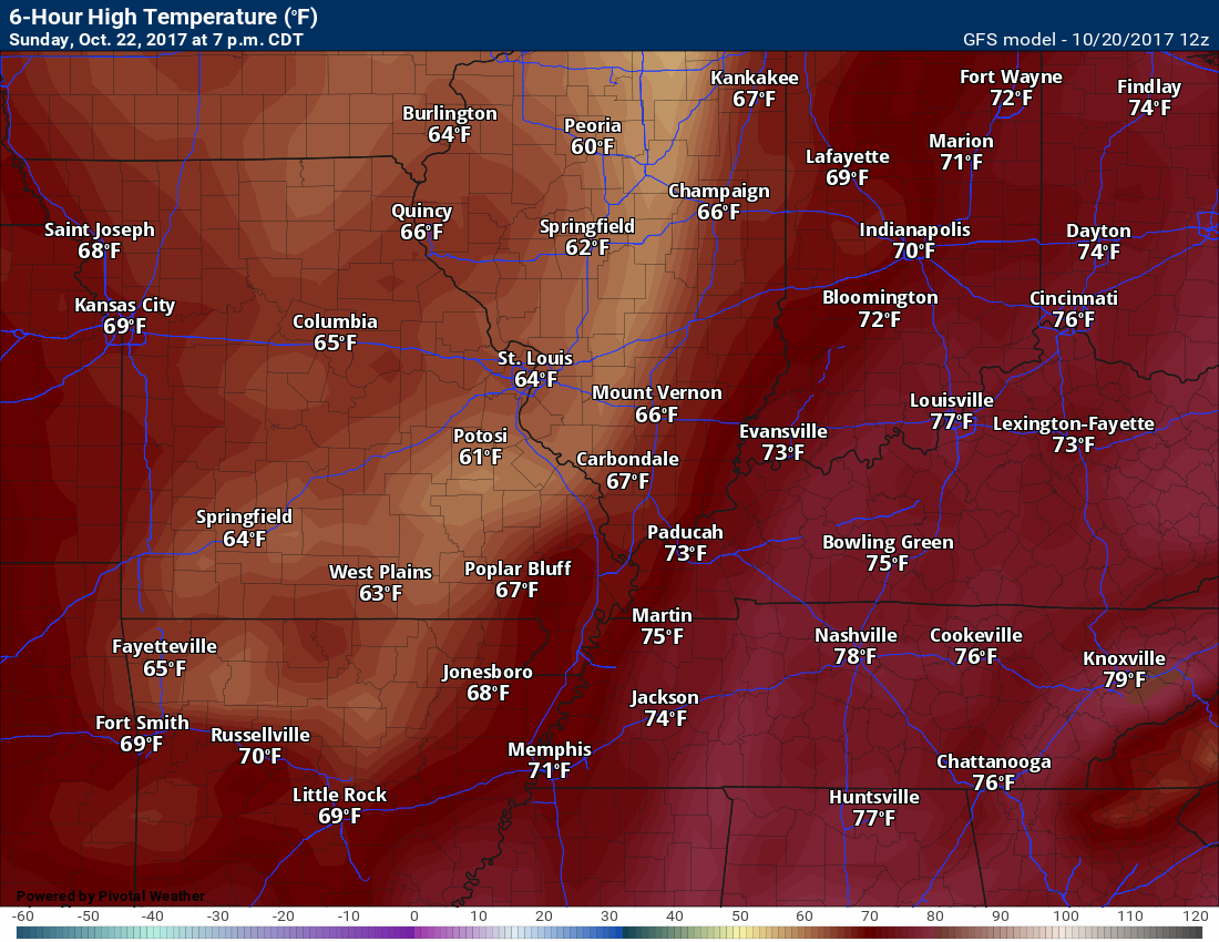
Sunday
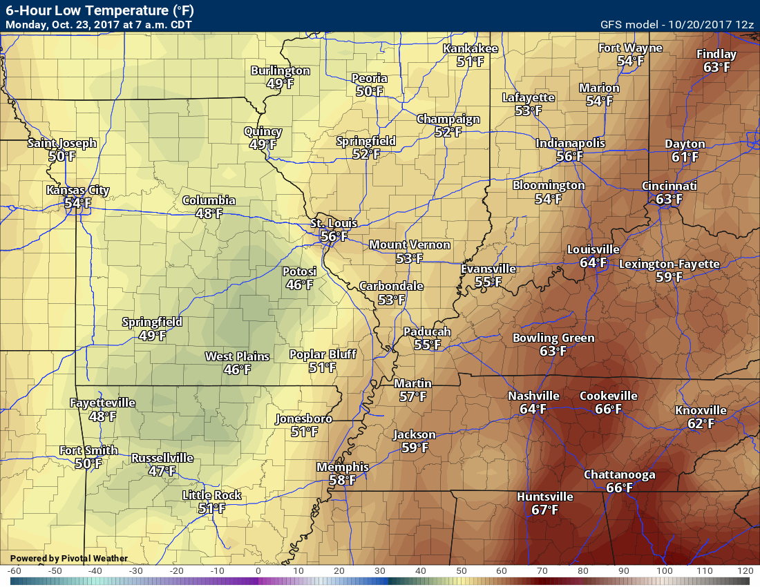
Sunday night lows
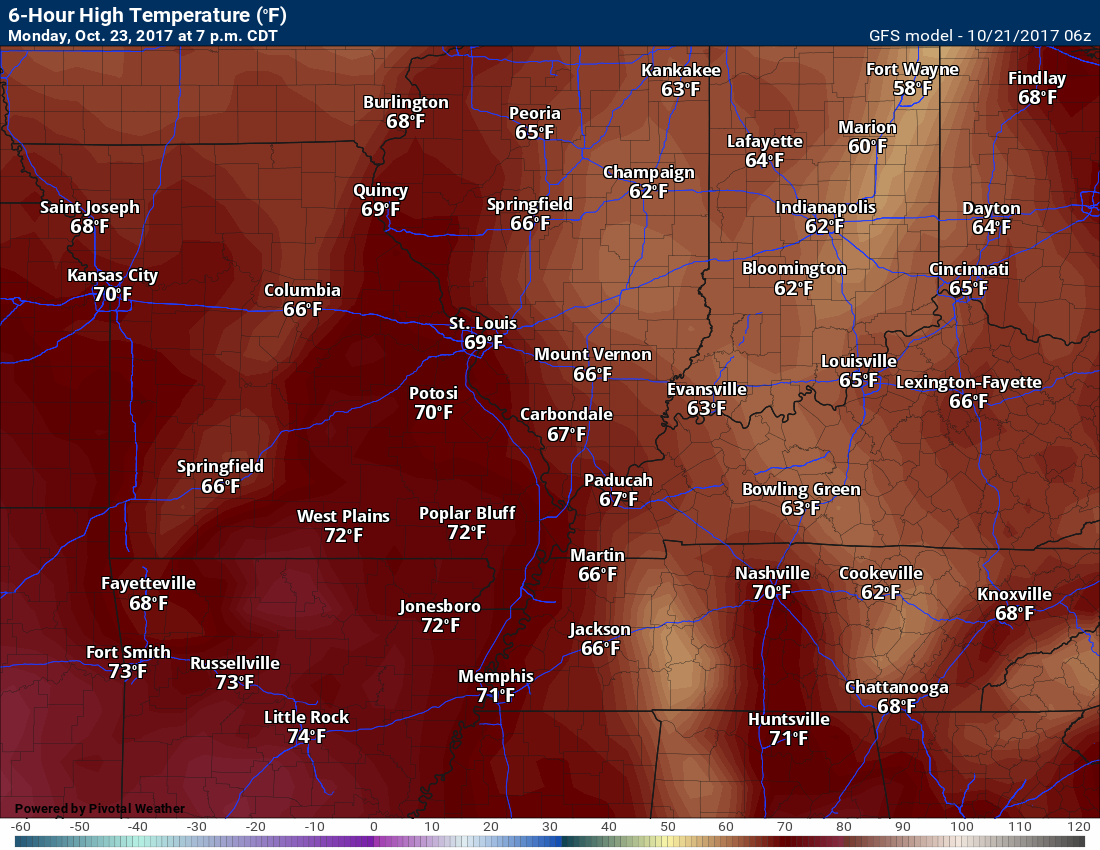
Monday high temperatures
Monday low temperatures
Dew Point Scale
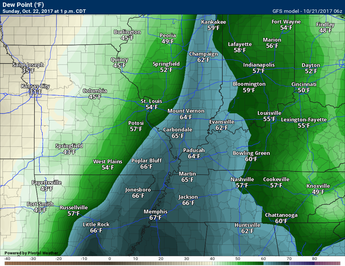
Dew points control how you feel outside. Higher dew points feel sticky. Lower dew points make the atmosphere comfortable.

Dew Point Forecast
Sunday
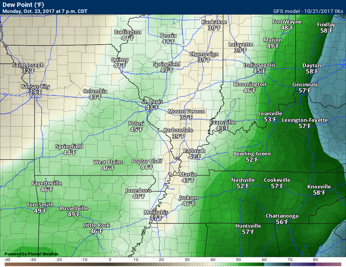
Monday
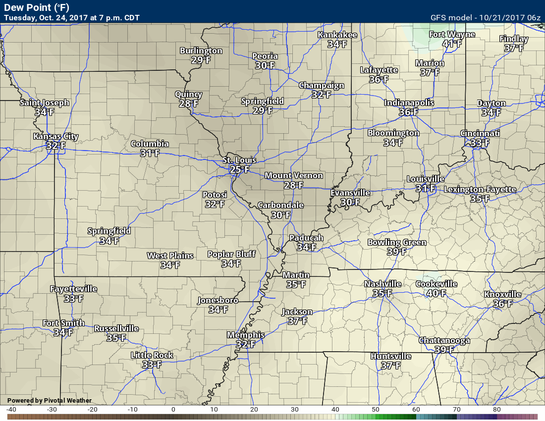
Tuesday
Cooler air arrives and dew points drop.
Long range forecast discussion
View the long-range discussion and videos here ~ CLICK LONG RANGE LINK
Subscribers see the long-range forecast/video on the Weather Talk page.
Subscriptions are $3 a month. This helps cover the $1000 to $2000 monthly costs.
Subscribe at www.beaudodsonweather.com
.
Are you subscribing to Weather Talk app/text messages and videos? This is what helps support all of the data you see each day.
We now offer premium videos for the short and long-range forecasts! These videos are produced by a team of long-range forecast experts. They are brought to you as bonus information. Activate text option four in order to receive these on your app or via text.
Subscribe at www.beaudodsonweather.com
We offer an Apple and Android app (scroll to the bottom of this page for more information).

Were you aware that I hired a team of meteorologists for long range videos?
To learn more, click this link
http://cms.weathertalk.com/meet-the-team/
.


We offer regional radars and local city radars – if a radar does not update then try another one. Occasional browsers need their cache cleared. You may also try restarting your browser. This will usually fix any problems.
During the winter you can track snow and ice by clicking the winterize button on the local city view interactive radars.
You may email me at beaudodson@usawx.com
Interactive Weather Radar Page. Choose the city nearest your location: Click this link
National interactive radar: Click this link.
The Beau Dodson Weather APP is ready for Apple and Android users. The app provides a faster way for you to receive my text messages. ATT and Verizon are not always reliable when it comes to speed.
Some of you have asked if you can receive the texts on your phone and the app. The answer to that is, yes. The Android app will automatically allow that to happen. On the Apple app, however, you will need to open your app and click the settings button. Make sure the green tab is OFF. Off means you will still receive the texts to your phone and the app. If you have any questions, then email me at beaudodson@usawx.com
The app is for text subscribers.
The direct download, for the Apple app, can be viewed here
https://itunes.apple.com/us/app/id1190136514
Here is the download link for the Android version Click Here
If you have not signed up for the texting service then you may do so at www.beaudodsonweather.com


——————————————————–
Your support helps with the following:

and

.

Whom do you trust for your weather information?
I have studied weather, in our region, since the late 1970’s. I have 40 years of experience in observing our regions weather patterns. My degree is in Broadcast Meteorology and a Bachelor’s of Science.
My resume includes:
Member of the American Meteorological Society.
NOAA Weather-Ready Nation Ambassador.
Meteorologist for McCracken County Emergency Management. I served from 2005 through 2015.
Meteorologist for McCracken County Rescue. 2015 through current
I own and operate the Southern Illinois Weather Observatory.
I am the chief meteorologist for Weather Talk LLC.
I am also a business owner in western Kentucky.
Recipient of the Mark Trail Award, WPSD Six Who Make A Difference Award, Kentucky Colonel, and the Caesar J. Fiamma” Award from the American Red Cross.
In 2005, I helped open the largest American Cross shelter in U.S. history. This was in Houston, Texas. I was deployed to help with the aftermath of Hurricane Katrina and Hurricane Rita. I was a shelter manager of one of the Houston, Texas shelter divisions.
In 2009 I was presented with the Kentucky Office of Highway Safety Award.
Recognized by the Kentucky House of Representatives for my service to the State of Kentucky leading up to several winter storms and severe weather outbreaks.
If you click on the image below you can read the Kentucky House of Representatives Resolution.

I am President of the Shadow Angel Foundation which serves portions of western Kentucky and southern Illinois.
There is a lot of noise on the internet. A lot of weather maps are posted without explanation. You need a trusted source for information.
My forecast philosophy is simple and straight forward.
- Communicate in simple terms
- To be as accurate as possible within a reasonable time frame before an event
- Interact with you on Twitter, Facebook, email, texts, and this blog
- Minimize the “hype” that you might see through other weather sources
- Push you towards utilizing wall-to-wall LOCAL TV coverage during severe weather events

Sign up for my AWARE email by clicking here.
I typically send AWARE emails before severe weather, winter storms, or other active weather situations. I do not email watches or warnings. The emails are a basic “heads up” concerning incoming weather conditions