WeatherTalk monthly operating costs can top $2000.00. Your $5 subscription helps pay for those costs. I work for you.
The $5 will allow you to register up to seven phones!
For $5 a month you can receive the following. You may choose to receive these via your WeatherTalk app or regular text messaging.
Severe weather app/text alerts from my keyboard to your app/cell phone. These are hand typed messages from me to you. During tornado outbreaks, you will receive numerous app/text messages telling you exactly where the tornado is located.
- Daily forecast app/texts from my computer to your app/cell phone.
- Social media links sent directly to your app/cell phone. When I update the blog, videos, or Facebook you will receive the link.
- AWARE emails. These emails keep you well ahead of the storm. They give you several days of lead time before significant weather events.
- Direct access to Beau via text and email. Your very own personal meteorologist. I work for you!
- Missouri and Ohio Valley centered video updates
- Long-range weather videos
- Week one, two, three and four temperature and precipitation outlooks.
Monthly outlooks. - Your subscription also will help support several local charities.
Would you like to subscribe? Subscribe at www.beaudodsonweather.com

I encourage subscribers to use the app vs regular text messaging. We have found text messaging to be delayed during severe weather. The app typically will receive the messages instantly. I recommend people have three to four methods of receiving their severe weather information.
Remember, my app and text alerts are hand typed and not computer generated. You are being given my personal attention during significant weather events.

WWW.WEATHERTALK.COM subscribers, here is my day to day schedule for your weather products.
These are bonus videos and maps for subscribers. I bring these to you from the BAMwx team. I pay them to help with videos.
The Ohio and Missouri Valley videos cover most of our area. They do not have a specific Tennessee Valley forecast but may add one in the future.
The long-range video is technical. Over time, you can learn a lot about meteorology from the long range video. Just keep in mind, it is a bit more technical.


October 02, 2018
Tuesday Forecast Details
Forecast: Partly cloudy. Warm and humid. A widely scattered shower or thundershower possible. Greatest chances over eastern portions of western Kentucky. That would mean the Pennyrile area. Lesser chances as you move further and further west.
Temperatures: MO ~ 86 to 88 IL ~ 84 to 86 KY ~ 83 to 86 TN ~ 84 to 88
What is the chance of precipitation? MO ~ 20% IL ~ 20% KY ~ 40% TN ~ 30%
Coverage of precipitation: Widely scattered to scattered
Wind: South at 4 to 8 mph with gusts to 14 mph
What impacts are anticipated from the weather? Scattered wet roadways. A stray lightning strike possible.
My confidence in the forecast verifying: High
Is severe weather expected? No
The NWS defines severe weather as 58 mph wind or great, 1″ hail or larger, and/or tornadoes
Should I cancel my outdoor plans? No, but glance at the radars
UV Index: 5 to 6 Moderate
Sunrise: 6:52 AM
Tuesday Night Forecast Details:
Forecast: Clearing and warm. Any remaining showers will come to an end. Mild. Patchy dense fog possible.
Temperatures: MO ~ 66 to 70 IL ~ 66 to 70 KY ~ 66 to 70 TN ~ 66 to 70
What is the chance of precipitation? MO ~ 10% mainly early IL ~ 20% mainly early KY ~ 20% mainly early TN ~ 20% mainly early
Coverage of precipitation: Ending early
Wind: South at 3 to 6 mph
What impacts are anticipated from the weather? Lower visibility if fog forms.
My confidence in the forecast verifying: High
Is severe weather expected? No
The NWS defines severe weather as 58 mph wind or great, 1″ hail or larger, and/or tornadoes
Should I cancel my outdoor plans? No
Sunset: 6:37 PM
Moonrise: 11:59 PM Last Quarter
Moonset: 2:20 PM
October 03, 2018
Wednesday Forecast Details
Forecast: Partly to mostly sunny. Hot. Humid. Summer-like. Breezy, at times.
Temperatures: MO ~ 86 to 90 IL ~ 86 to 90 KY ~ 86 to 90 TN ~ 86 to 90
What is the chance of precipitation? MO ~ 10% IL ~ 10% KY ~ 5% TN ~ 5%
Coverage of precipitation: Most likely none
Wind: South and southwest at 10 t0 20 mph with higher gusts. Strongest winds over southeast Missouri and southern Illinois.
What impacts are anticipated from the weather? Most likely none.
My confidence in the forecast verifying: High
Is severe weather expected? No
The NWS defines severe weather as 58 mph wind or great, 1″ hail or larger, and/or tornadoes
Should I cancel my outdoor plans? No
UV Index: 6 to 8 High
Sunrise: 6:53 AM
Wednesday Night Forecast Details:
Forecast: A few clouds. Warm and humid.
Temperatures: MO ~ 68 to 72 IL ~ 68 to 72 KY ~ 68 to 72 TN ~ 68 to 72
What is the chance of precipitation? MO ~ 10% IL ~ 10% KY ~ 0% TN ~ 0%
Coverage of precipitation: Most likely none
Wind: South and southwest at 8 to 16 mph with gusts above 20 mph. Again, strongest winds will be over southeast Missouri and southern Illinois.
What impacts are anticipated from the weather? None
My confidence in the forecast verifying: Medium
Is severe weather expected? No
The NWS defines severe weather as 58 mph wind or great, 1″ hail or larger, and/or tornadoes
Should I cancel my outdoor plans? No
Sunset: 6:36 PM
Moonrise: 12:30 AM Waning Crescent
Moonset: 3:15 PM
October 04, 2018
Thursday Forecast Details
Forecast: Partly to mostly sunny. Hot. Humid. Scattered showers and thunderstorms (mainly across our northern counties). Greatest chance along I64 with increasing chances north of there.
Temperatures: MO ~ 78 to 88 (lower temps northern counties vs southern. This is because of clouds and some scattered precipitation over our northern counties) IL ~ 78 to 88 Warmest temperatures near the Ohio River. Less warm near Mt. Vernon, because of clouds and scattered precipitation KY ~ 86 to 90 TN ~ 86 to 90
What is the chance of precipitation? MO ~ 40% (mainly north) IL ~ 40% to 50% near I64 and less than 20% near the Ohio River KY ~ 20% TN ~ 10%
Coverage of precipitation: Scattered (mainly our northern counties)
Wind: South and southwest at 6 to 12 mph with gusts to 20 mph
What impacts are anticipated from the weather? Northern counties will have some wet roadways and lightning.
My confidence in the forecast verifying: Medium
Is severe weather expected? No
The NWS defines severe weather as 58 mph wind or great, 1″ hail or larger, and/or tornadoes
Should I cancel my outdoor plans? No, but check radars (esp over our northern counties)
UV Index: 2 to 4 northern counties and 5 to 6 over the rest of the area. Low to High
Sunrise: 6:53 AM
Thursday Night Forecast Details:
Forecast: Partly cloudy. Mild. Dry across most of the region. A few showers or thunderstorms possible (mainly across our northern counties). Greatest chance along I64 with increasing chances north of there.
Temperatures: MO ~ 64 to 58 IL ~ 64 to 68 KY ~ 68 to 70 TN ~ 68 to 70
What is the chance of precipitation? MO ~ 30% to 40% northern counties decreasing to 10% over the Bootheel IL ~ 40% near the I64 corridor diminishing to 10% near the Ohio River KY ~ 20% TN ~ 10%
Coverage of precipitation: Scattered near I64 decreasing to none to isolated over the Bootheel into west KY/west TN
Wind: South at 6 to 12 mph
What impacts are anticipated from the weather? Spotty wet roadways and lightning (most likely along and north of I64)
My confidence in the forecast verifying: Medium
Is severe weather expected? No
The NWS defines severe weather as 58 mph wind or great, 1″ hail or larger, and/or tornadoes
Should I cancel my outdoor plans? No, but check radars
Sunset: 6:34 PM
Moonrise: 1:35 AM Waning Crescent
Moonset: 4:04 PM
October 05, 2018
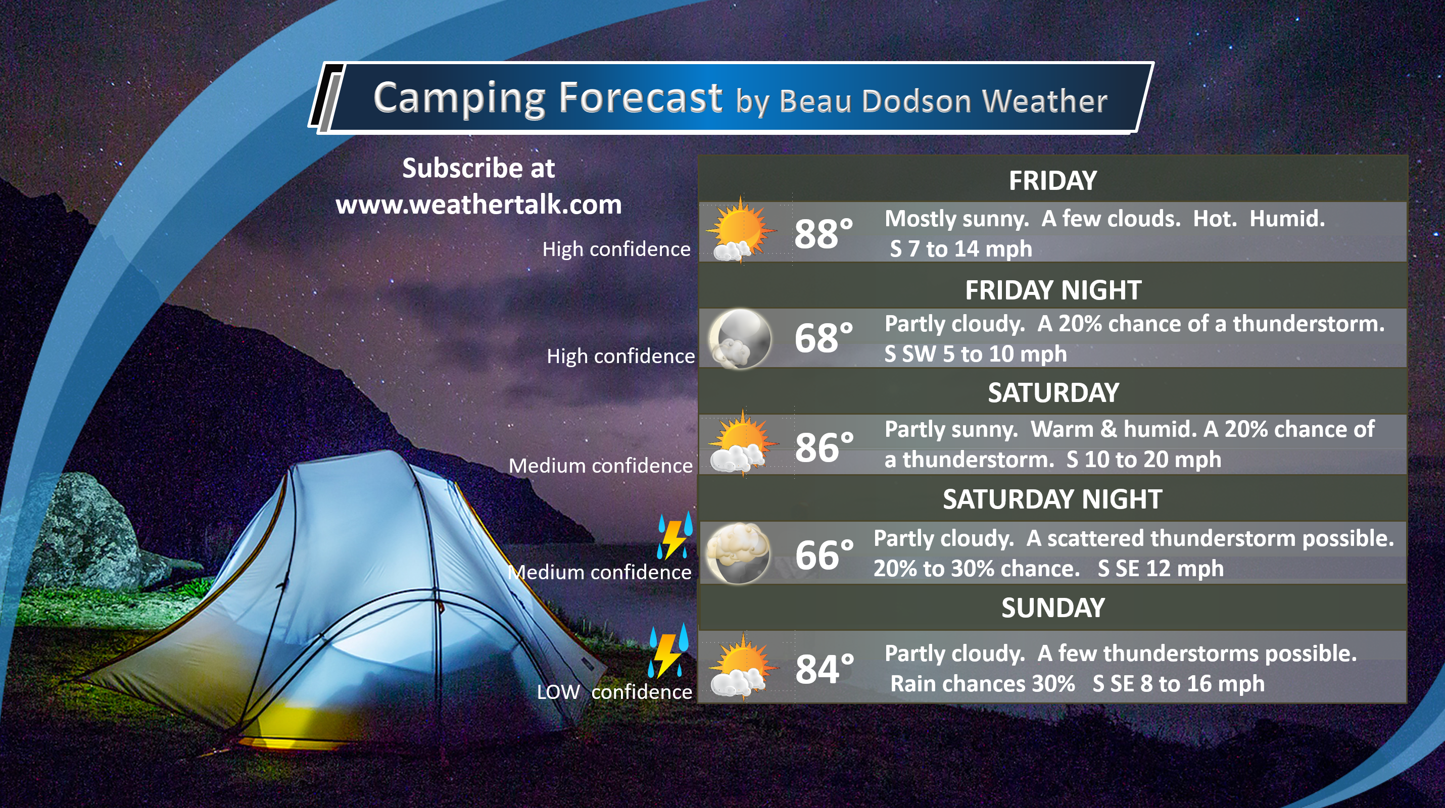
Friday Forecast Details
Forecast: Mostly sunny. Hot and humid. A few afternoon clouds. A chance of a shower or thunderstorm over northern portions of southern Illinois (close to I64).
Temperatures: MO ~ 85 to 90 IL ~ 85 to 90 KY ~ 85 to 90 TN ~85 to 90
What is the chance of precipitation? MO ~ 20% IL ~ 20% KY ~ 10% TN ~ 10%
Coverage of precipitation: Most likely none. An isolated shower or storm over northern/northeastern portions of southern Illinois.
Wind: South at 8 to 16 mph with gusts occasional gusts above 20 mph
What impacts are anticipated from the weather? Most likely none.
My confidence in the forecast verifying: Medium
Is severe weather expected? No
The NWS defines severe weather as 58 mph wind or great, 1″ hail or larger, and/or tornadoes
Should I cancel my outdoor plans? No
UV Index: 6 to 8 High
Sunrise: 6:54 AM
Friday Night Forecast Details:
Forecast: Partly cloudy. Most of the area should remain dry. A chance of a shower or thunderstorm over southeast Missouri and southern Illinois
Temperatures: MO ~ 66 to 70 IL ~ 66 to 70 KY ~ 66 to 70 TN ~ 66 to 7o
What is the chance of precipitation? MO ~ 30% IL ~ 30% KY ~ 10% TN ~ 10%
Coverage of precipitation: Widely scattered mainly over southeast Missouri and southern Illinois.
Wind: South at 7 to 14 mph and gusty
What impacts are anticipated from the weather? A few wet roadways and lightning. Again, mainly over southeast Missouri and southern Illinois. The further north and west you travel the greater the chance of a few showers and storms.
My confidence in the forecast verifying: Low to medium
Is severe weather expected? No
The NWS defines severe weather as 58 mph wind or great, 1″ hail or larger, and/or tornadoes
Should I cancel my outdoor plans? No, but check the radars
Sunset: 6:33 PM
Moonrise: 4:48 PM Waning Crescent
Moonset: 2:43 AM
LOW CONFIDENCE ON THE WEEKEND FORECAST
MONITOR UPDATES
RAIN CHANCES MAY NEED ADJUSTING.
October 06, 2018
Saturday Forecast Details
Forecast: Partly sunny. Warm and humid. A chance of a shower or thunderstorm, especially western and northern counties from Poplar Bluff, Missouri, towards Mt Vernon, Illinois.
Temperatures: MO ~83 to 86 IL ~ 83 to 86 KY ~ 84 to 88 TN ~ 84 to 88 If we have more clouds, then temperatures will be a few degrees cooler.
What is the chance of precipitation? MO ~ 30% IL ~ 30% KY ~ 20% TN ~ 20%
Coverage of precipitation: Widely scattered
Wind: South at 7 to 14 mph with gusts to 18 mph
What impacts are anticipated from the weather? Wet roadways. Lightning. Greater chances over southeast Missouri and southern Illinois. Most of the area may remain dry if the front doesn’t push its way into the area.
My confidence in the forecast verifying: LOW
Is severe weather expected? No
The NWS defines severe weather as 58 mph wind or great, 1″ hail or larger, and/or tornadoes
Should I cancel my outdoor plans? I would monitor updates and radars. There could be some precipitation in the region.
UV Index: 6 High
Sunrise: 6:55 AM
Saturday Night Forecast Details:
Forecast: Partly to mostly cloudy. A shower or thunderstorm possible. Especially western and northern counties from Poplar Bluff, Missouri, towards Mt Vernon, Illinois.
Temperatures: MO ~ 63 to 66 IL ~ 63 to 66 KY ~ 64 to 68 TN ~ 64 to 68
What is the chance of precipitation? MO ~ 30% IL ~ 30% KY ~ 20% TN ~ 20%
Coverage of precipitation: Isolated
Wind: South and southeast at 5 to 10 mph with gusts to 14 mph
What impacts are anticipated from the weather? Wet roadways. Lightning possible.
My confidence in the forecast verifying: LOW
Is severe weather expected? No
The NWS defines severe weather as 58 mph wind or great, 1″ hail or larger, and/or tornadoes
Should I cancel my outdoor plans? Monitor updates.
Sunset: 6:31 PM
Moonrise: 3:53 AM Waning Crescent
Moonset: 5:27 PM
October 07, 2018
Sunday Forecast Details
Forecast: Partly sunny. Warm. An isolated shower or thunderstorm possible. Clouds will help determine high temperatures. Fewer clouds and we will be warmer.
Temperatures: MO ~ 82 to 86 IL ~ 82 to 86 KY ~ 83 to 86 TN ~ 83 to 86
What is the chance of precipitation? MO ~ 20% IL ~ 20% KY ~ 20% TN ~ 20%
Coverage of precipitation: Isolated
Wind: South and southeast winds at 7 to 14 mph with gusts to 20 mph
What impacts are anticipated from the weather? A few wet roadways possible. Isolated lightning.
My confidence in the forecast verifying: LOW
Is severe weather expected? Unlikely
The NWS defines severe weather as 58 mph wind or great, 1″ hail or larger, and/or tornadoes
Should I cancel my outdoor plans? No, but monitor updates
UV Index: 5 Moderate
Sunrise: 6:56 AM
Sunday Night Forecast Details:
Forecast: Partly cloudy. A slight chance of showers and thunderstorms.
Temperatures: MO ~ 62 to 66 IL ~ 62 to 66 KY ~ 64 to 68 TN ~ 64 to 68
What is the chance of precipitation? MO ~ 20% IL ~ 20% KY ~ 20% TN ~ 20%
Coverage of precipitation: Scattered
Wind: Southeast at 6 to 12 mph
What impacts are anticipated from the weather? Some patchy fog could lower visibility. Isolated showers would mean wet roadways and possibly some lightning.
My confidence in the forecast verifying: LOW
Is severe weather expected? Unlikely
The NWS defines severe weather as 58 mph wind or great, 1″ hail or larger, and/or tornadoes
Should I cancel my outdoor plans? Monitor updates
Sunset: 6:30 PM
Moonrise: 5:03 AM Waning Crescent
Moonset: 6:04 PM
October 08, 2018
Monday forecast: Partly cloudy. Warm. A slight chance of thunderstorms.
Temperatures: MO ~ 82 to 86 IL ~ 82 to 86 KY ~ 82 to 86 TN ~ 82 to 86
What is the chance of precipitation? MO ~ 20% IL ~ 20% KY ~ 20% TN ~ 20%
Coverage of precipitation: None to isolated
Wind: South and southeast at 6 to 12 mph
What impacts are anticipated from the weather? Isolated wet roadways and lightning.
My confidence in the forecast verifying: LOW
Is severe weather expected? Unlikely
The NWS defines severe weather as 58 mph wind or great, 1″ hail or larger, and/or tornadoes
Should I cancel my outdoor plans? Monitor updates
UV Index: 6 High
Sunrise: 6:57 AM
Monday Night Forecast Details:
Forecast: Partly cloudy. An isolated shower or thunderstorm.
Temperatures: MO ~ 62 to 66 IL ~ 62 to 66 KY ~ 62 to 66 TN ~ 62 to 66
What is the chance of precipitation? MO ~ 20% IL ~ 20% KY ~ 20% TN ~ 20%
Coverage of precipitation: Isolated
Wind: Southeast winds at 6 to 12 mph
What impacts are anticipated from the weather? Wet roadways. Lightning.
My confidence in the forecast verifying: LOW
Is severe weather expected? No
The NWS defines severe weather as 58 mph wind or great, 1″ hail or larger, and/or tornadoes
Should I cancel my outdoor plans? Monitor updates
Sunset: 6:28 PM
Moonrise: 6:12 AM Waning Crescent
Moonset: 6:38 PM
Learn more about the UV index readings. Click here.

Here is the latest WPC/NOAA rainfall outlook.
This graphic will take us into next Tuesday morning.
The WPC/NOAA has painted fairly light totals across portions of the Central United States.
Medium confidence in the precipitation forecast.
Notice the heavy band of rain from Texas into Wisconsin. That is in response to a frontal boundary and tropical moisture. Most of the model guidance keeps this heavy rain to our northwest.
Click to enlarge
Notice the heavy rain to our west. That is partly because of Rosa (a Pacific hurricane)
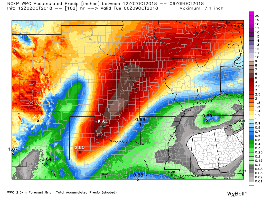
I will keep an eye on rain chances this weekend. I would not change plans. Not yet.
Rain chances may be closer to 40% to 50% over southeast Missouri and southern Illinois. Rain chances over western Kentucky and northwest Tennessee will likely hover around the 30% to 40%.
Some data indicates overall chances Saturday and Sunday may be even lower. I will monitor guidance and update as necessary.
Need a forecast for an outdoor event?


We offer interactive local city live radars and regional radars.
If a radar does not update then try another one. If a radar does not appear to be refreshing then hit Ctrl F5 on your keyboard.
You may also try restarting your browser. The local city view radars also have clickable warnings.
During the winter months, you can track snow and ice by clicking the winterize button on the local city view interactive radars.

Questions? Broken links? Other questions?
You may email me at beaudodson@usawx.com

The National Weather Service defines a severe thunderstorm as one that produces quarter size hail or larger, 58 mph winds or greater, and/or a tornado.
Today through Thursday: A few thunderstorms are possible today. Severe weather is not anticipated and many areas will remain dry. There will be small thunderstorm chances over the coming days. The greatest chance will be along and north of I64 in southern Illinois. Elsewhere, chances will be less than 20%.
I am monitoring a cold front this weekend, but it appears the greatest rain chances may remain to our north and west.
Severe weather is not anticipated.
Interactive live weather radar page. Choose the city nearest your location. If one of the cities does not work then try a nearby one. Click here.
National map of weather watches and warnings. Click here.
Storm Prediction Center. Click here.
Weather Prediction Center. Click here.

Live lightning data: Click here.

Interactive GOES R satellite. Track clouds. Click here.

Here are the latest local river stage forecast numbers Click Here.
Here are the latest lake stage forecast numbers for Kentucky Lake and Lake Barkley Click Here.

- Above normal temperatures through at least Sunday
- A few clouds and low-end rain chances today and tonight
- Monitoring rain chances Thursday and Thursday night over our northern counties
- Monitoring a cold front this weekend into next week
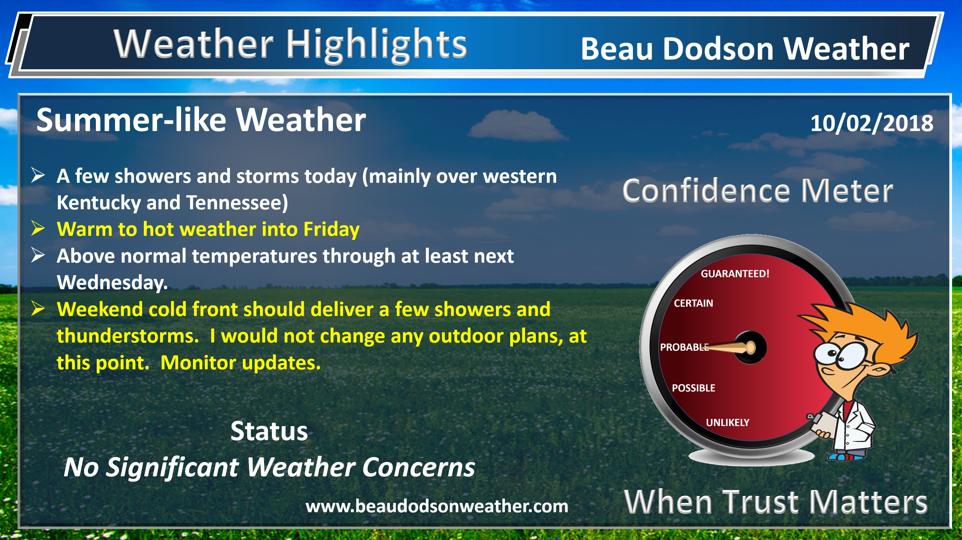
Warm weather will rule through the rest of this week into early next week (and possibly beyond). Temperatures will be well above normal. That equals high temperatures in the middle to upper 80’s. The only exception will be where clouds are a bit thicker and a few showers occur.
Some 90 degree readings are certainly possible over the coming days. Again, well above seasonal norms.
The rain chances over the coming days will be fairly limited (for most). A few showers and thunderstorms will occur today. The greatest chances will be over western Kentucky. The greatest chance in western Kentucky will be the Pennyrile area.
Elsewhere, a few showers and thunderstorms will be possible, but many areas will simply remain dry.
Check out the water vapor satellite imagery this morning. Notice the swirl in the southwest? That is Hurricane Rosa. This was once a strong hurricane. This will help infuse moisture into the Central United States over the coming days. Heavy rain totals are likely from Texas into Kansas and then into Wisconsin. Notice that on the rain charts that I posted above.
I am monitoring the I64 corridor for a greater chance of showers and perhaps a few thunderstorms Thursday and Thursday night. This will be in response to a cold front that will dip into portions of southeast Missouri and southern Illinois. The front will return northward as a warm front by Friday. This will likely limit the greater chances of showers and thunderstorms to our northern counties.
Rain chances will increase this weekend as a cold front draws closer to the region. Even then, the chances may remain at or below 50%.
A strong ridge of high pressure will be fighting against the frontal boundary pushing south and southeast. If the ridge is strong enough then the front won’t make much progress. At this time, I do have shower and thunderstorm chances in the forecast, but I have kept them at or below 50%. Monitor updates if you have weekend plans. I would not change any plans.
If the front does make it into our region, it would be Saturday and Sunday. It would then return northward as a warm front Sunday afternoon into Sunday night/Monday. That returns us to the heat ridge (more warm temperatures).
High pressure causes sinking air. It is also responsible for our summer temperatures. A southeast ridge is normally warm. High pressure that digs into our region from Canada, during the winter months, can cause bitterly cold air. Two different types of high pressure.
No solid cold shots are in the charts through the middle of next week. There are some signals of cooler than normal weather as we move towards the third week of October. Confidence isn’t all that great in the eventual outcome of that portion of the forecast. Model guidance has done poorly lately.
The good news is that warm weather will continue. Good news for those who love warm weather. For those wanting autumn temperatures, you will have to wait a bit longer.
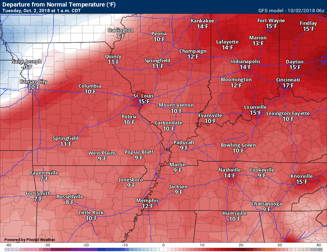
Let me show you an animation of temperature anomalies.
What are anomalies? Anomalies show you the difference between normal and expected high or low temperatures. Here is the temperature animation map for the next 240 hours. This is the GFS model.
Red would be above normal temperatures. Impressive, isn’t it?
Normal high temperatures are in the middle 70’s. Normal lows are in the 50’s.
![]()
Here is the preliminary fall outlook from the long-range meteorology team.
Click to enlarge this graphic.
.
![]()
The September forecast has been updated.
![]()

I bring these to you from the BAMwx team. They are excellent long-range forecasters.
Remember, long-range outlooks are a bit of skill, understanding weather patterns, and luck combined. It is not an exact science.

This product is for subscribers.
Subscribe at www.weathertalk.com
Subscriber graphics can be viewed on this page CLICK HERE

This product is for subscribers.

Subscriber graphics can be viewed on this page CLICK HERE
![]()
.
Fall Outlook!
Preliminary October precipitation outlook
Here is the preliminary November temperature and precipitation outlook
Preliminary November temperature outlook
Preliminary November precipitation outlook
.These products are for subscribers.
![]()

A new weather podcast is now available! Weather Geeks (which you might remember is on The Weather Channel each Sunday)
To learn more visit their website. Click here.
![]()

WeatherBrains Episode 662
Joining us for this episode of WeatherBrains is the Chief Meteorologist at Wichita’s KAKE-TV, and former Birmingham resident Jay Prater. Jay came to KAKE from Panama City, Florida, where he was the morning meteorologist for WJHG-TV. He also worked as the Managing Meteorologist for WSMV-TV in Nashville, Tennessee, and WAFF-TV in Huntsville, Alabama. During his time in Huntsville, he was a weather consultant to the contractor of the Unity Module. Today Unity is in orbit, as a key component of the International Space Station. Jay’s television career began working weekends for WVTM-TV in his native Birmingham, Alabama starting in 1987. Jay, welcome to WeatherBrains!
Other discussions in this weekly podcast include topics like:
- The 1974 Super Outbreak and how it got Jay Prater into weather as a 4th grader
- Bill Murray’s May 2004 storm chasing trip
- The 2007 Greensburg tornado
- How radio plays a role in teaching broadcasting skills, and how the business model has changed over the decades
- Astronomy Outlook with Tony Rice
- and more!
.
Link to their website https://weatherbrains.com/
Previous episodes can be viewed by clicking here.

We offer interactive local city live radars and regional radars. If a radar does not update then try another one. If a radar does not appear to be refreshing then hit Ctrl F5. You may also try restarting your browser.
The local city view radars also have clickable warnings.
During the winter months, you can track snow and ice by clicking the winterize button on the local city view interactive radars.
You may email me at beaudodson@usawx.com
Find me on Facebook!

Find me on Twitter!

Did you know that a portion of your monthly subscription helps support local charity projects?
You can learn more about those projects by visiting the Shadow Angel Foundation website and the Beau Dodson News website.

I encourage subscribers to use the app vs regular text messaging. We have found text messaging to be delayed during severe weather. The app typically will receive the messages instantly. I recommend people have three to four methods of receiving their severe weather information.
Remember, my app and text alerts are hand typed and not computer generated. You are being given personal attention during significant weather events.
