Friday morning update
Severe weather outlook
Severe weather is not anticipated through Saturday afternoon.
There will be a chance for thunderstorms late Saturday night into Sunday, especially over southeast Missouri and southwest Illinois. Lightning is the primary concern. There is a small risk of high winds with thunderstorms.
Forecast
Good morning, everyone!
Welcome to the weekend. Lengthy update, because there have been some changes in the guidance.
**some changes possible to the Sunday forecast**
Complicated forecast for Sunday. Questionable probabilities as you move east of the Mississippi River.
Highlights
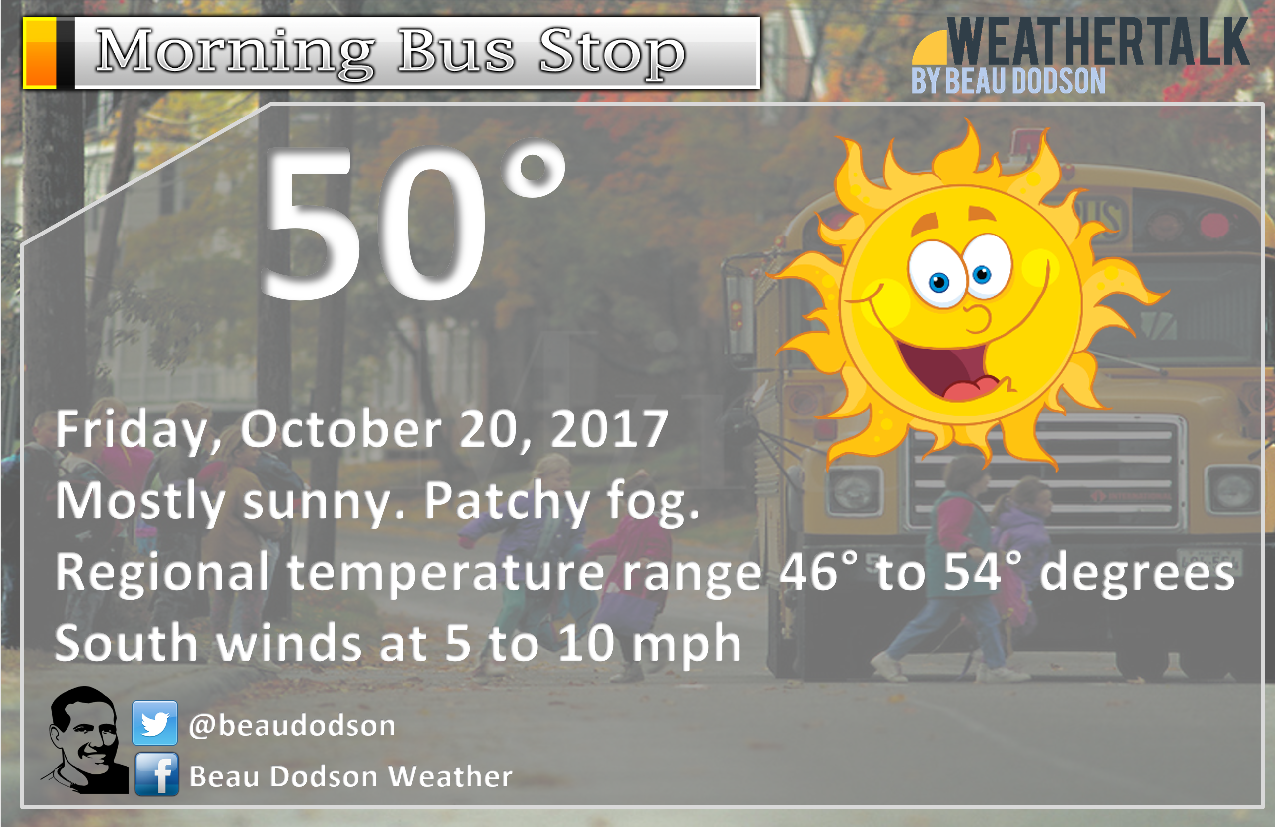
1. Warm today. Some high clouds moving in from the southwest.
2. Mild tonight. Dry.
3. Increasing clouds on Saturday with a few scattered showers. The best chances will
be over southeast Missouri, extreme western Kentucky, and southwest Illinois. Many areas will remain dry. Warm. Becoming breezy as the day wears on.
4. Increasing rain chances over the western half of the region (SE MO/SW IL) as we push deeper into Saturday night, Sunday, and Sunday night.
5. Questionable probabilities for Sunday’s rain event.
6. A second rain system Sunday night/Monday.
Friday and Friday night.
A beautiful day is on tap for the region. A few patches of fog this morning will soon mix out.
We will have some increase in high clouds streaming in from the southwest. This will be in response to a weak system pushing out of Oklahoma and Texas. No rain anticipated today or tonight.
Saturday
Clouds increase on Saturday. Quite warm with temperatures well into the 70’s. There will be enough lift and moisture to pop a couple of showers. I would not make any changes to my Saturday outdoor plans. I would suggest checking radars from time to time. Showers would be moving from the S/SW towards the N/NE
Winds may become gusty the further we push into the afternoon hours.
Saturday night and Sunday
Forecast changes may be necessary based on new data. There are now questions as to how much rain coverage there will be on Sunday across portions of the region.
On Saturday night, a cold front will push towards the region from the west. This front will be accompanied by warm and windy conditions ahead of it.
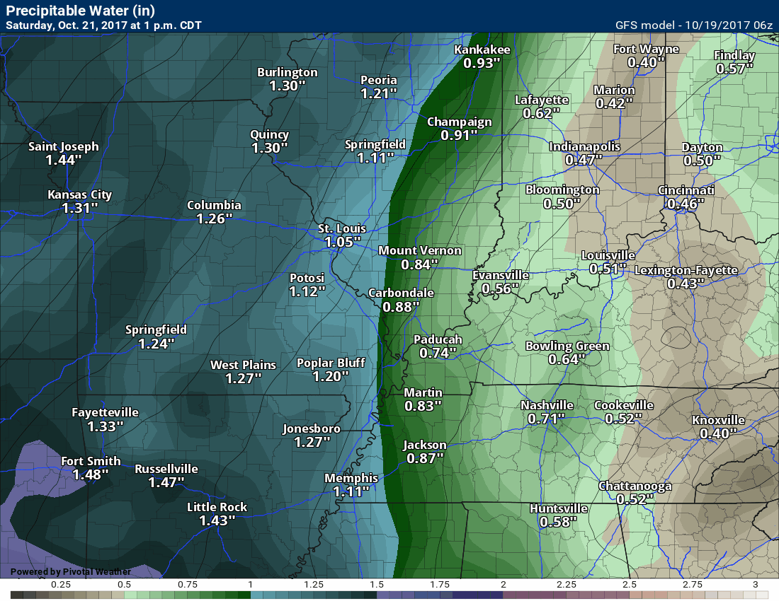
Moisture will stream northward. PWAT values ( a measure of moisture in the entire atmosphere) will be 1.75 to 2.00″. That is a lot of moisture for October. That does not mean it will rain that much. It just means the atmosphere is juiced.
This moisture will combine with the lift from the cold front to set off widespread showers and thunderstorms from Iowa and Nebraska south into Texas.
Severe thunderstorms are likely to our west over western Missouri, eastern Kansas, portions of Oklahoma, Texas, and Arkansas.
I am not too concerned about severe thunderstorms in our local area. The risk is small.
As we move through Saturday night, the band of showers and thunderstorms will push eastward. It will weaken with time. The later we move into the night, the better the rain chances for southeast Missouri and southwest Illinois.
Rain will first arrive in southeast Missouri between 12 am and 3 am. The rain will then slowly push eastward. It may eventually stall for a period of time on Sunday.
This is when the forecast becomes complicated.
**There are some questions about rain coverage on Sunday. Confidence in the forecast has decreased**
Looking at the data it appears that the band of weakening showers and thunderstorms might have some difficulty pulling east.
It is possible that the best rain coverage, through 2 PM on Sunday, will be west of the Mississippi River. Perhaps decreasing coverage and intensity as you move further east of the Mississippi River.
Two things are likely to happen.
Southeast Missouri and southwest Illinois will almost certainly see rain late Saturday night and Sunday morning.
That would include areas from Randolph County south to Alexander County. From there westward stands the best chance of widespread precipitation.
The weakening band of showers and thunderstorms may begin to break up a bit as it pushes into southeast Illinois, western Kentucky, and northwest Tennessee. This is a question.
A second system is likely to develop over Arkansas and Louisiana Sunday afternoon and Sunday night.
This system will slow the progress of the cold front. The front will hang in our region longer.
Additional moisture will stream north and east with this second system. This will interact with the cold front.
Showers will likely increase in coverage late Sunday into Sunday night across Kentucky and Tennessee. How far west and northwest these news showers develop is questionable.
This leaves us with some question on rain chances from 8 am on Sunday through 5 pm on Sunday. This is especially true for southeast Illinois, western Kentucky and Tennessee.
If you have outdoor plans on Sunday, then I would suggest having a plan B.
Even if the heavier rain does not spread too far east of the Mississippi River, there will at least be thick clouds and shower chances.
The Pennyrile area of western Kentucky will likely see the least rain on Sunday before 3 pm. Keep that in mind.
Rainfall totals on Saturday night through Sunday afternoon for southeast Missouri and southwest Illinois will likely be in the 0.40″ to 0.80″ range with higher totals possible. Rain totals further east of the Mississippi River (through Sunday afternoon) may be less. Perhaps in the 0.25″ to 0.50″ range.
Additional rain is likely Sunday night into Monday.
What is the chance of X amount of rain falling?
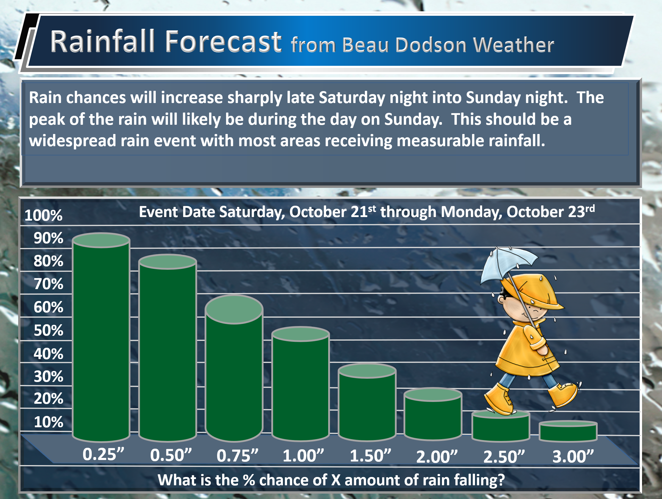
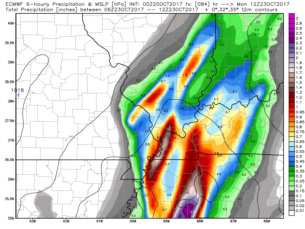
Let me show you the EC guidance. These are forecast rainfall totals.
Notice how we do have a decrease on Sunday from west to east. A weakening band of showers and thunderstorms. The real question is how much do they weaken.
At the very least plan on showers.
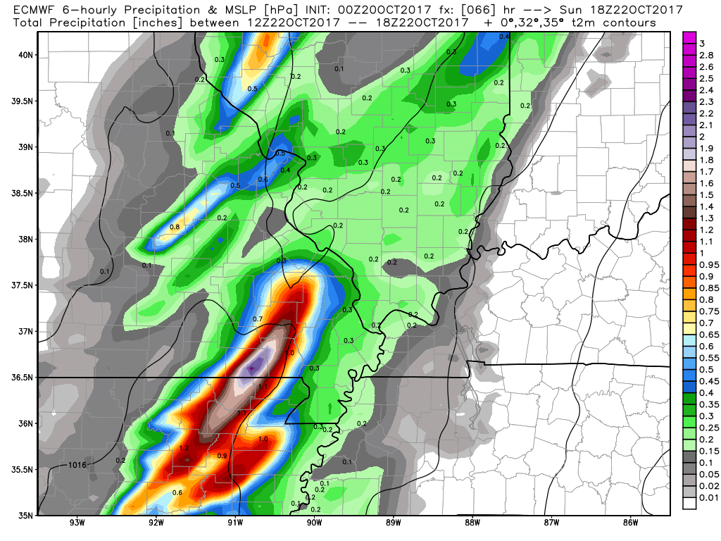
These are the EC guidance rainfall totals from 7 am on Sunday through 1 pm on Sunday.
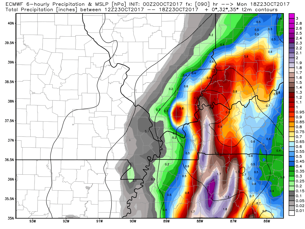
These are the rain totals from 1 pm on Sunday through 7 pm on Sunday (according to the EC guidance)
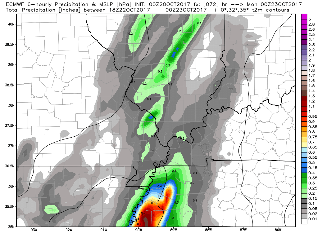
Notice how the totals increase as the second system moves into the region Sunday evening.
The path of that second system is questionable and confidence is low.
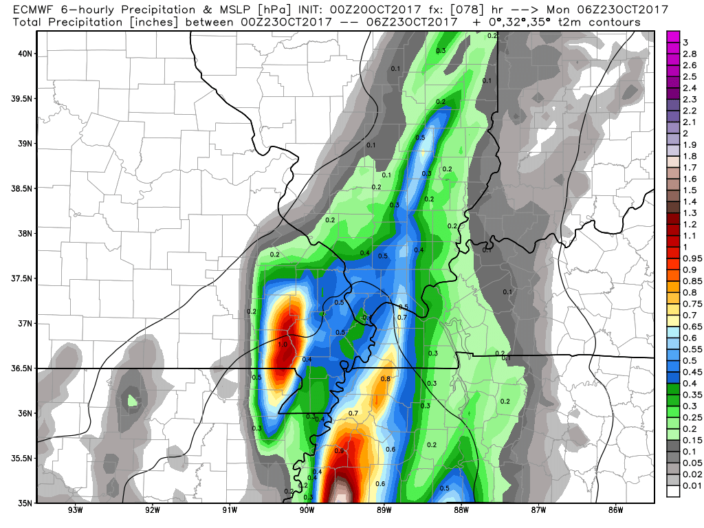
Rain totals from 7 pm on Sunday through 1 am on Monday
Rain totals from 1 am on Monday through 7 am on Monday. Highly dependent on the track of the second system.
The EC is bullish on heavier rain late Sunday night into Monday. Again, highly dependent on the track of the second system. Very little confidence on that (at least for now).
Rain totals from 7 am until 1 pm on Monday


.
A Weather Talk subscription ($3 a month) is required to view the videos. This helps cover monthly costs (which can run between one and two thousand dollars).
Videos are posted on the www.weathertalk.com website. Once there, click the Beau Video-Cast tab. Long Range Video Update
If you believe you missed a video then you may check the LIVE FEED link on the Weather Talk website. You will find an archive of videos on that page.
You can also receive the videos via your Weather Talk app/text messages. Turn text option FOUR to the on position. The Weather Extra text option. Sign up for the app/text messages, videos, and more at www.beaudodsonweather.com
.
This forecast covers the counties in red. The counties in orange are covered by the forecast discussion further down in the blog.


.
October 19, 2017
Thursday Night Forecast Details:
Forecast: Mostly clear. Not quite as cool as recent nights.
Temperatures: MO ~ 48 to 54 IL ~ 48 to 52 KY ~ 48 to 54
Winds: Southerly winds at 4 to 8 mph with gusts to 10 mph
What impacts are anticipated from the weather? None.
My confidence in the forecast verifying: High.
Is severe weather expected? No
The NWS defines severe weather as 58 mph winds or great, 1″ hail or larger, and/or tornadoes
What is the chance of precipitation? MO ~ 0% IL ~ 0% KY ~ 0%
Coverage of precipitation: None
Should I cancel my outdoor plans? No
.
October 20, 2017
Friday Forecast Details
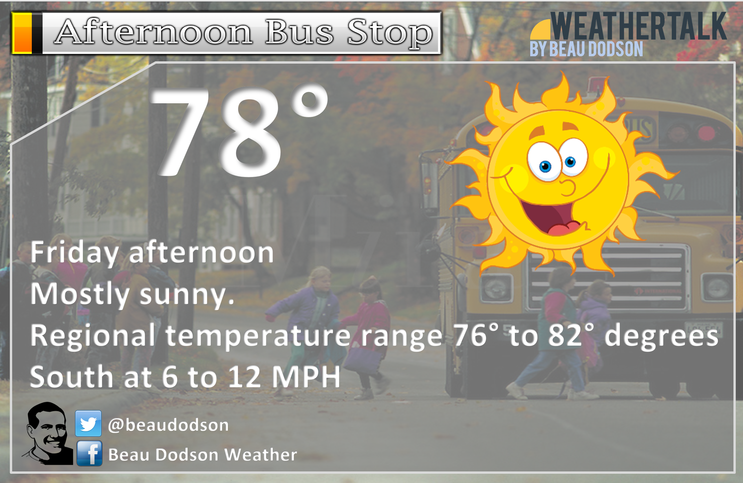
Forecast: Partly to mostly sunny. Pleasant. Warm for October.
Temperatures: MO ~ 76 to 82 IL ~ 75 to 80 KY ~ 76 to 80
Winds: South at 5 to 10 mph with gusts to 12 mph
What impacts are anticipated from the weather? None
My confidence in the forecast verifying: High
Is severe weather expected? No
The NWS defines severe weather as 58 mph winds or great, 1″ hail or larger, and/or tornadoes
What is the chance of precipitation? MO ~ 0% IL ~ 0% KY ~ 0%
Coverage of precipitation: None
Should I cancel my outdoor plans? No
.
Friday Night Forecast Details:
Forecast: Partly cloudy. Mild.
Temperatures: MO ~ 55 to 58 IL ~ 55 to 58 KY ~ 55 to 58
Winds: Southerly winds at 6 to 12 mph increasing late.
What impacts are anticipated from the weather? None
My confidence in the forecast verifying: High
Is severe weather expected? No
The NWS defines severe weather as 58 mph winds or great, 1″ hail or larger, and/or tornadoes
What is the chance of precipitation? MO ~ 0% IL ~ 0% KY ~ 0%
Coverage of precipitation: None
Should I cancel my outdoor plans? No
.
October 21, 2017
Saturday Forecast Details
Forecast: Breezy. A mix of sun and clouds. Isolated showers possible, especially over southeast Missouri. I would not change any of my Saturday plans, but perhaps check radar. Warm.
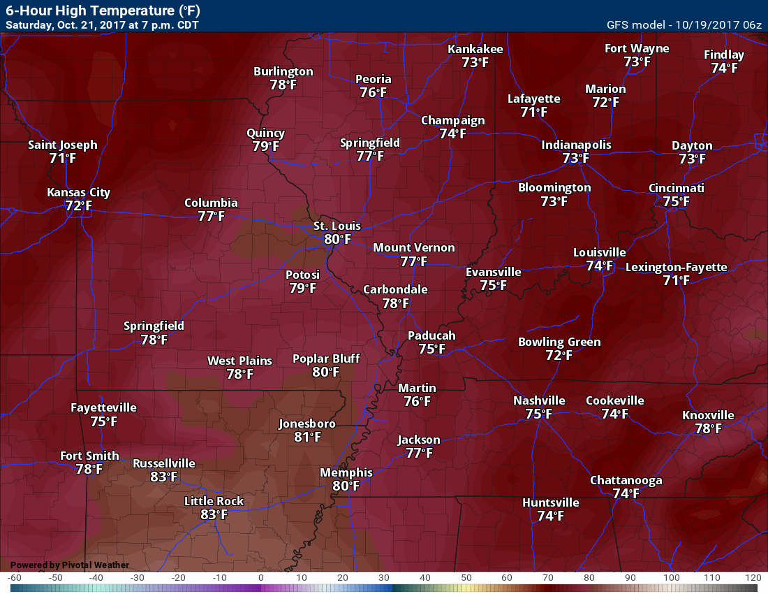
Temperatures: MO ~ 76 to 82 IL ~ 76 to 82 KY ~ 76 to 82
Winds: South at 10 to 20 mph. Gusty winds.
What impacts are anticipated from the weather? Wet roadways.
My confidence in the forecast verifying: Medium.
Is severe weather expected? No
The NWS defines severe weather as 58 mph winds or great, 1″ hail or larger, and/or tornadoes
What is the chance of precipitation? MO ~ 30% IL ~ 20% KY ~ 20%
Coverage of precipitation: Isolated
Should I cancel my outdoor plans? No, but check radars.
.
Saturay Night Forecast Details:
Forecast: Becoming clouds. Breezy. A few scattered showers before midnight. Increasing chances of showers after midnight. A thunderstorm possible.
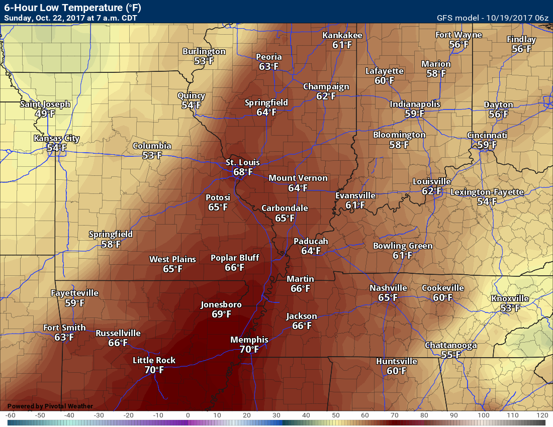
Temperatures: MO ~ 58 to 64 IL ~ 58 to 64 KY ~ 58 to 64
Winds: South winds at 7 to 14 mph with gusts to 25 mph
What impacts are anticipated from the weather? Lightning. Wet roadways possible after midnight.
My confidence in the forecast verifying: Medium
Is severe weather expected? No
The NWS defines severe weather as 58 mph winds or great, 1″ hail or larger, and/or tornadoes
What is the chance of precipitation? MO ~ 60% (esp late) IL ~ 50% KY ~ 30%
Coverage of precipitation: Perhaps scattered early. Increasing coverage late at night.
Should I cancel my outdoor plans? No
.
October 22, 2017
Sunday Forecast Details
Forecast: Cloudy. A good chance of showers and thunderstorms for southeast Missouri and southwest Illinois. The band of rain might weaken as it pushes further east of the Mississippi River. This raises some questions as to rain coverage between 8 am and 4 pm for southeast Illinois, western Kentucky, and Tennessee. Have a plan B in case it does rain.
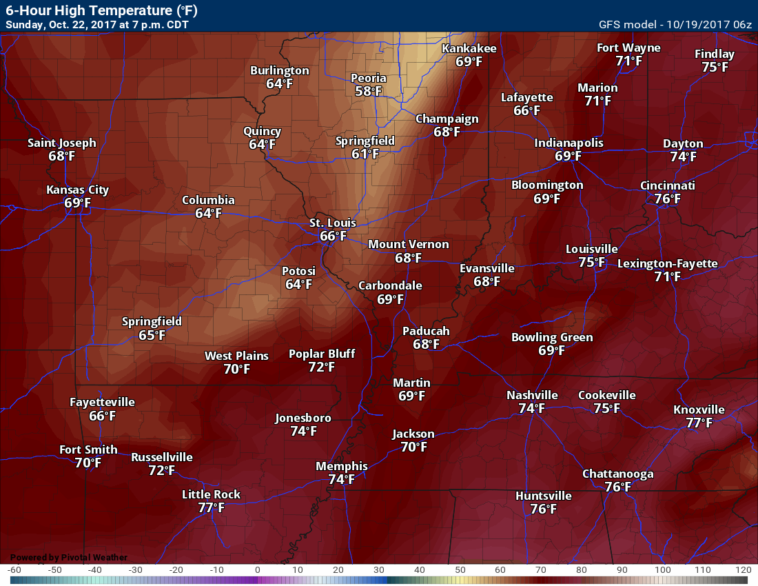
Temperatures: MO ~ 73 to 76 IL ~ 73 to 76 KY ~ 73 to 76
Winds: South and southwest at 6 to 12 mph
What impacts are anticipated from the weather? Lightning and wet roadways. Locally heavy rain.
My confidence in the forecast verifying: Medium
Is severe weather expected? Small risk for strong storms. Monitor updates.
The NWS defines severe weather as 58 mph winds or great, 1″ hail or larger, and/or tornadoes
What is the chance of precipitation? MO ~ 90% IL ~ 70% KY ~ 60%
Coverage of precipitation: Numerous
Should I cancel my outdoor plans? Monitor updates and have a plan B.
.
Sunday Night Forecast Details:
Forecast: Cloudy with rain showers likely.
Temperatures: MO ~ 52 to 56 IL ~ 52 to 56 KY ~ 54 to 58
Winds: West and northwest winds 6 to 12 mph
What impacts are anticipated from the weather? Wet roadways.
My confidence in the forecast verifying: Medium.
Is severe weather expected? No
The NWS defines severe weather as 58 mph winds or great, 1″ hail or larger, and/or tornadoes
What is the chance of precipitation? MO ~ 50% IL ~ 60% KY ~ 70%
Coverage of precipitation: Scattered to numerous.
Should I cancel my outdoor plans? Have a plan B early in the night.
.
October 23, 2017
Monday Forecast Details
Forecast: Low confidence in Monday’s forecast. Cloudy. Showers possible.
Temperatures: MO ~ 68 to 72 IL ~ 68 to 72 KY ~ 68 to 72
Winds: North and northeast winds at 6 to 12 mph
What impacts are anticipated from the weather? Wet roadways.
My confidence in the forecast verifying: LOW
Is severe weather expected? No
The NWS defines severe weather as 58 mph winds or great, 1″ hail or larger, and/or tornadoes
What is the chance of precipitation? MO ~ 40% IL ~ 40% KY ~ 40%
Coverage of precipitation:
Should I cancel my outdoor plans? Monitor updates.
.
Monday Night Forecast Details:
Forecast: Cloudy. A shower possible.
Temperatures: MO ~ 48 to 52 IL ~ 48 to 52 KY ~ 48 to 52
Winds: Northwest winds at 5 to 10 mph
What impacts are anticipated from the weather? Wet roadways.
My confidence in the forecast verifying: Low
Is severe weather expected? No
The NWS defines severe weather as 58 mph winds or great, 1″ hail or larger, and/or tornadoes
What is the chance of precipitation? MO ~ 30% IL ~ 30% KY ~ 30%
Coverage of precipitation:
Should I cancel my outdoor plans? Monitor updates
.
School Bus Stop Forecast for Friday
 The National Weather Service definition of a severe thunderstorm is one that produces quarter size hail or larger, 58 mph winds or greater, and/or a tornado.
Thursday night through Saturday afternoon: Severe weather is not anticipated.
Saturday night through Monday: Lightning is possible during this time period. There is a lot end risk for strong thunderstorms on Sunday, but confidence is low.
Tuesday through Friday: Severe weather is not anticipated.

Weather Highlights:
- Nice weather through Saturday morning
- Isolated showers possible Saturday, but most areas will remain dry. Windy.
- Rain chances ramp up quickly Saturday night into Sunday night.
- Low confidence on the Sunday night into Tuesday forecast.
- Frost next week?
The main weather story for the next 48 hours will be the nice weather. You can expect quite a bit of sunshine on Friday. Warm temperatures. Temperatures will pop into the middle and upper 70’s. Well above the normal highs of 68 to 72 degrees.
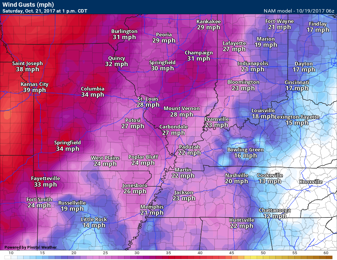
Winds will pick up on Saturday. Boaters use care. You can expect southerly winds at 10 to 20 mph with gusts above 25 mph. We will also have increasing clouds.
Wind gusts on Saturday
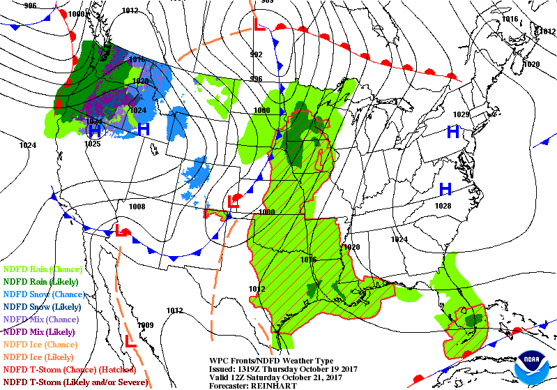
A cold front will be situated well to our west on Saturday. You can see that cold front on this map.
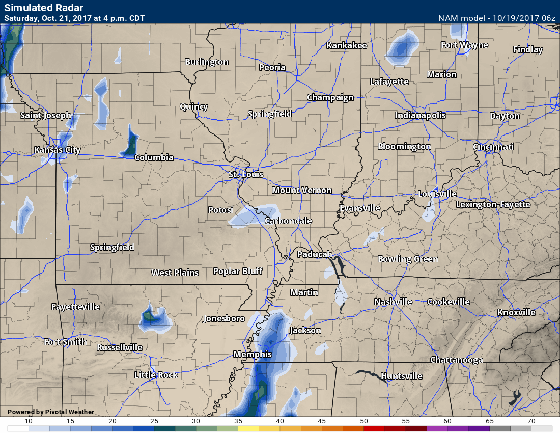
Guidance suggests a few fast morning showers will be possible on Saturday, mainly over southeast Missouri. Small chances elsewhere. Southeast Missouri rain chances will be around 20% to 30% and then 20% elsewhere. I would not change any of my Saturday plans based on the low end shower chances.
Here is the future-cast radar for Saturday afternoon. Isolated showers. Low end chance.
The weather will go downhill Saturday night into Monday.
A cold front will push towards the region on Sunday. This front will be accompanied by bands of showers and thunderstorms.
Rain may move into southeast Missouri and southwest Illinois as early as late Saturday night and then spread eastward from there.
If you have outdoor plans on Sunday, then have a plan B. Rain is likely.
Rainfall totals of 0.40″ to 0.80″ are likely to occur with this system. Pockets of greater than one inch are a good bet.
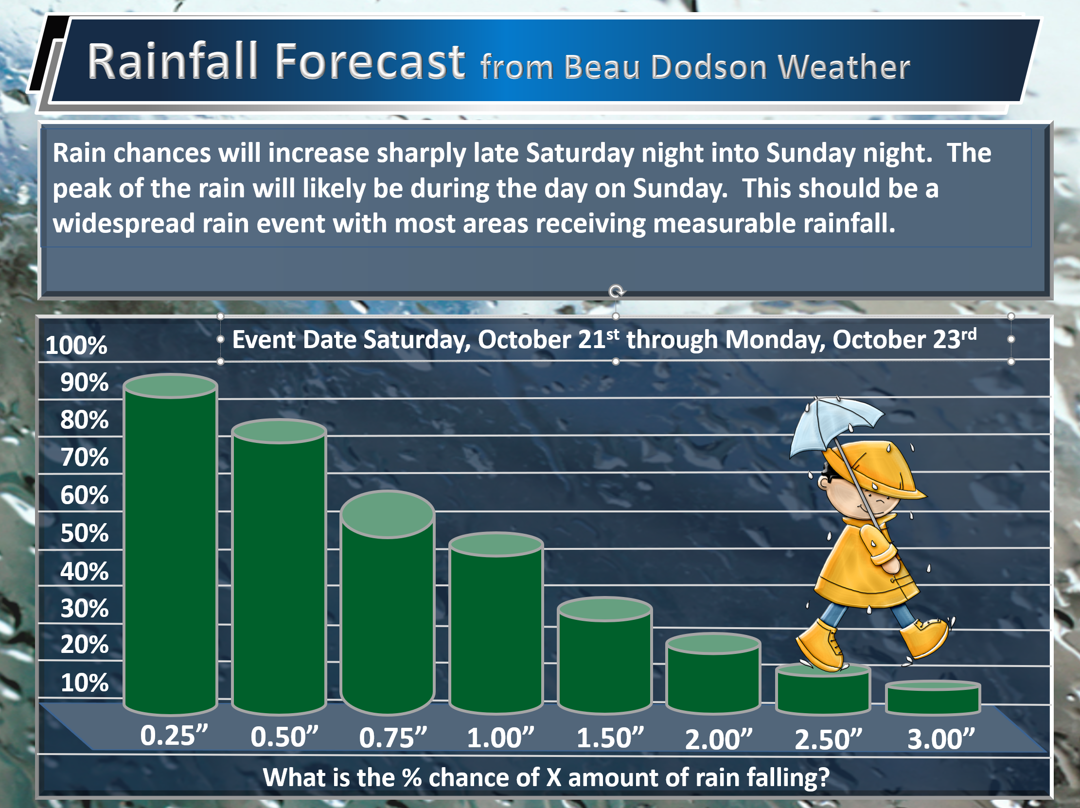
Here are my rain probability numbers. What is the % chance of X amount of rain falling?
PWAT values spike ahead of the cold front. These are big numbers for October. Near the top of the chart. PWAT is a measure of moisture in the entire atmosphere.
Higher numbers typically mean the potential for heavy rain.
Click to enlarge
Rain will likely continue into Sunday night.
We will have a risk of lightning with this event. Some of the guidance shows a low end severe weather risk for late Saturday night and Sunday. Confidence in the severe weather threat is low. I will monitor guidance trends. For now, the risk appears minimal.
Forecast confidence decreases Sunday night into Tuesday. See the long range discussion further down in this update.
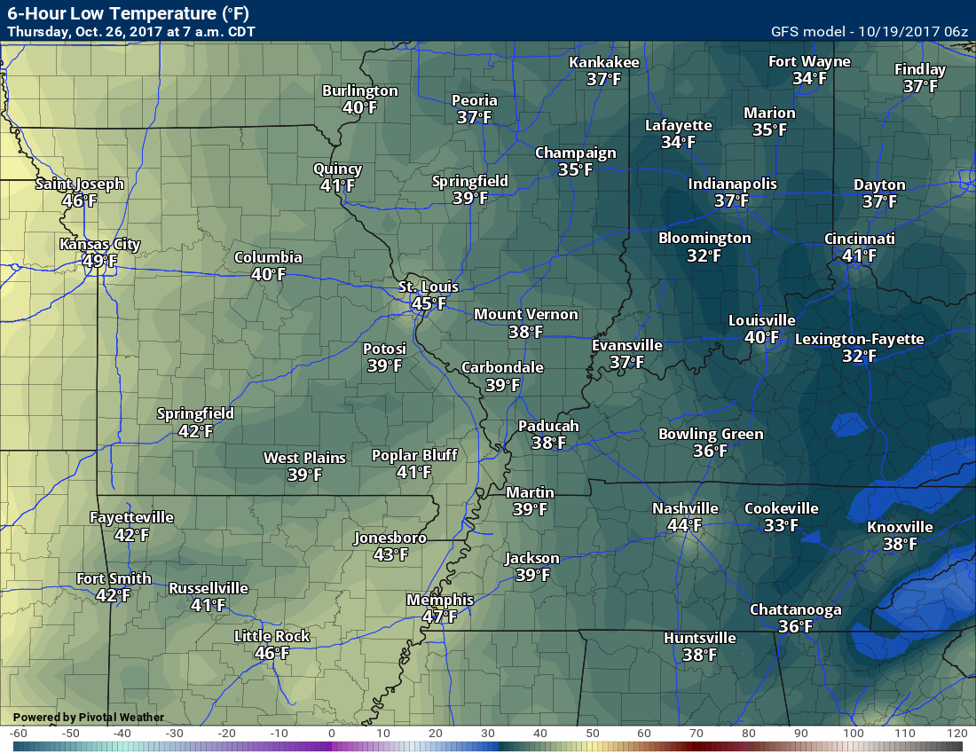
Temperature Forecast
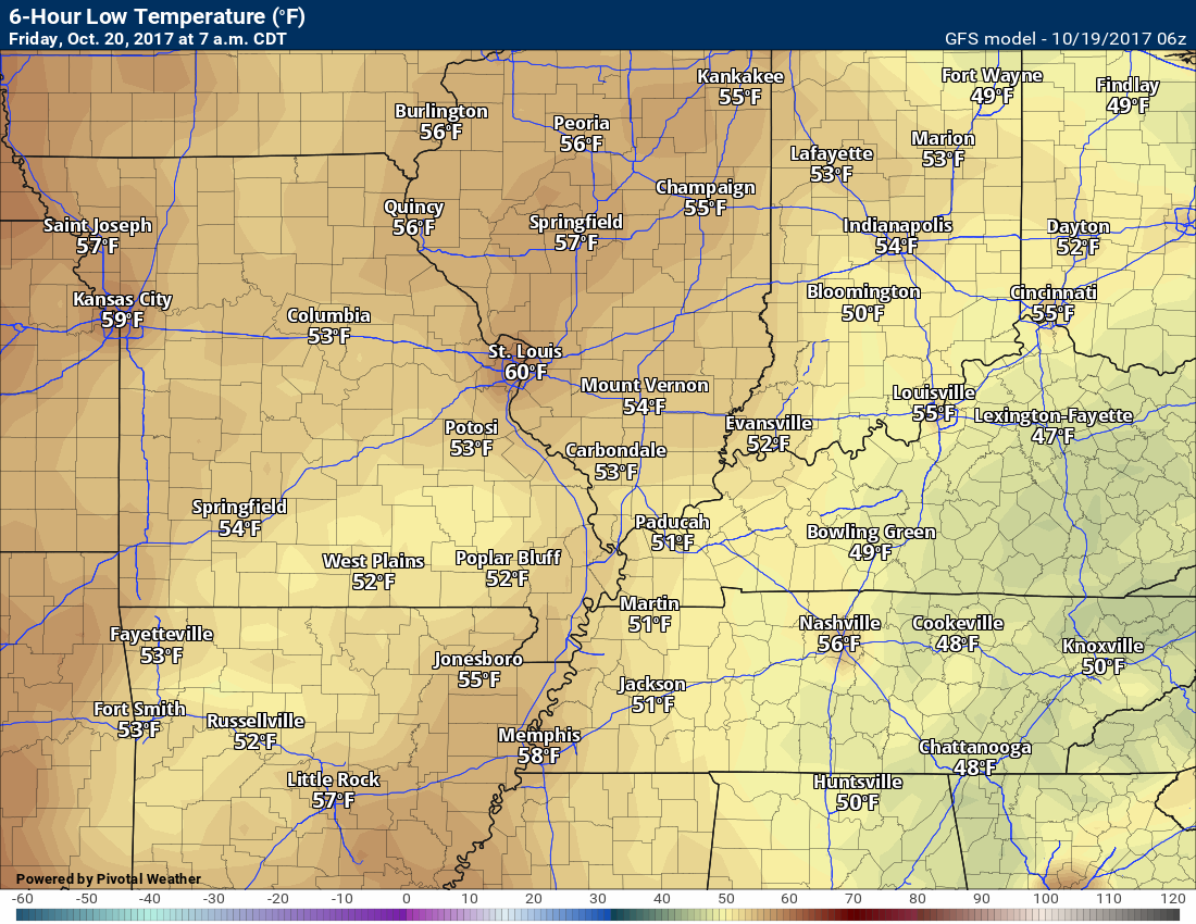
Thursday night lows
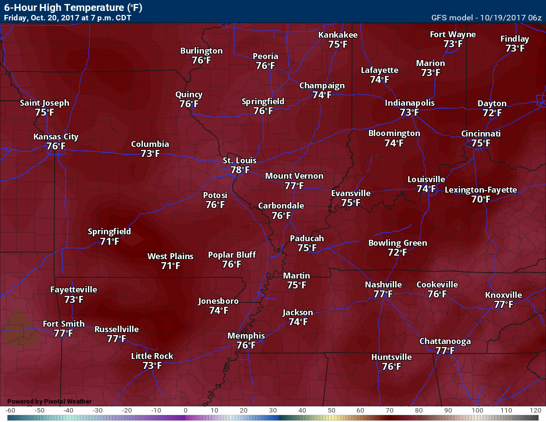
Friday highs
Friday night lows
Saturday
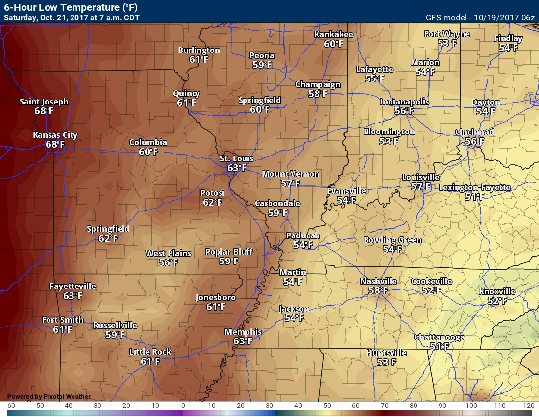
Saturday night lows
Sunday
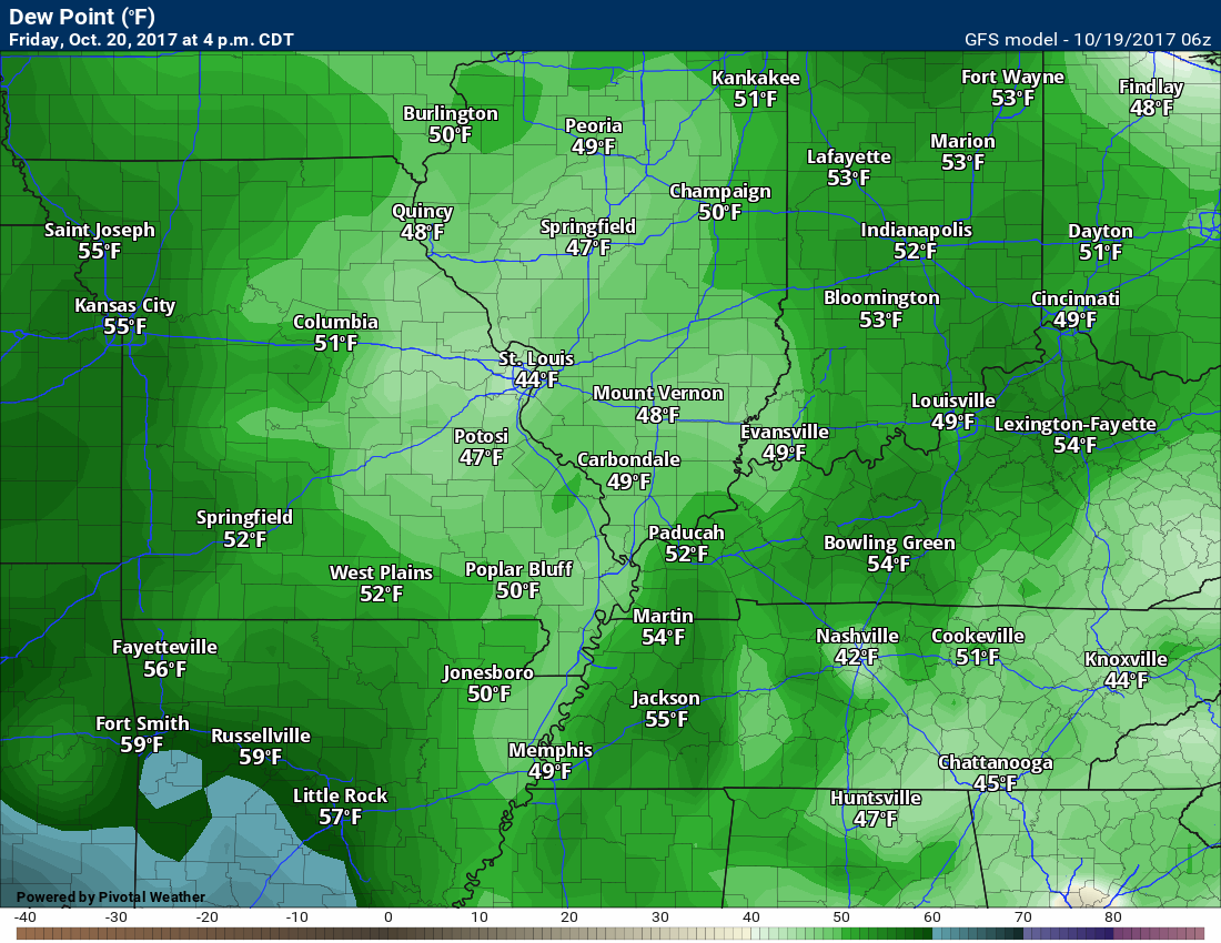
Dew Point Scale
Dew points control how you feel outside. Higher dew points feel sticky. Lower dew points make the atmosphere comfortable.

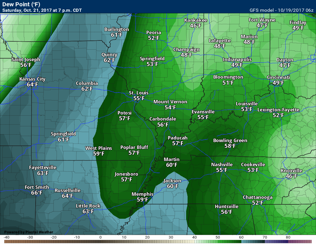
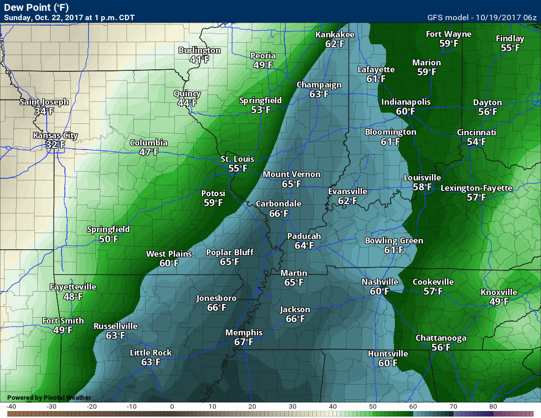
Dew Point Forecast
Friday
Saturday
Sunday
See how the moist air is pulled northward? This is ahead of a cold front. Our dew points will spike on Sunday.
Long range forecast discussion
Rain chances may continue into Monday and Tuesday. Confidence in the long range outlook is lower than normal.
There are major differences in guidance as to what happens with an area of low pressure on Sunday night and Monday.
This system is forecast to develop over Arkansas and Louisiana. This is a classic winter storm set-up for our region. The only thing missing is the cold air!
The track of this system will be key to whether we have quite a bit of additional rain or we dry out by Monday.
Let me show you some of the track differences.
This is the American GFS model guidance
GFS
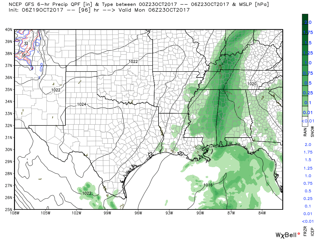
You can see it has a band of rain moving out of our area on Sunday night/Monday morning. Green is rain.
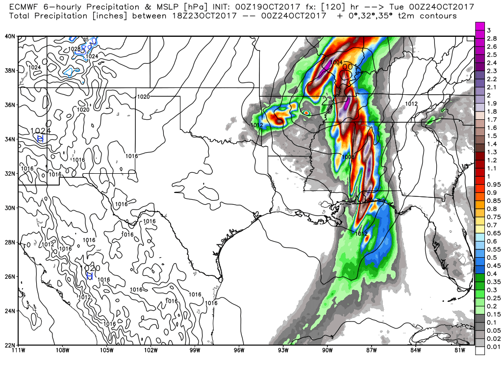
The EC has a totally different idea. The EC brings an area of low pressure over our area with heavy rain.
EC
Colder air is likely towards the middle/end of next week. We may have to deal with our first widespread frost. Still several days to monitor this concern.
Check out the guidance lows for Thursday morning. If this verifies, then frost is a good bet.
View the long range discussion and video here ~ CLICK LONG RANGE LINK
Subscribers see the long range forecast/video on the Weather Talk page.
Subscriptions are $3 a month. This helps cover the $1000 to $2000 monthly costs.
Subscribe at www.beaudodsonweather.com
.
Are you subscribing to Weather Talk app/text messages and videos? This is what helps support all of the data you see each day.
We now offer premium videos for the short and long-range forecasts! These videos are produced by a team of long-range forecast experts. They are brought to you as bonus information. Activate text option four in order to receive these on your app or via text.
Subscribe at www.beaudodsonweather.com
We offer an Apple and Android app (scroll to the bottom of this page for more information).

Were you aware that I hired a team of meteorologists for long range videos?
To learn more, click this link
http://cms.weathertalk.com/meet-the-team/
.


We offer regional radars and local city radars – if a radar does not update then try another one. Occasional browsers need their cache cleared. You may also try restarting your browser. This will usually fix any problems.
During the winter you can track snow and ice by clicking the winterize button on the local city view interactive radars.
You may email me at beaudodson@usawx.com
Interactive Weather Radar Page. Choose the city nearest your location: Click this link
National interactive radar: Click this link.
The Beau Dodson Weather APP is ready for Apple and Android users. The app provides a faster way for you to receive my text messages. ATT and Verizon are not always reliable when it comes to speed.
Some of you have asked if you can receive the texts on your phone and the app. The answer to that is, yes. The Android app will automatically allow that to happen. On the Apple app, however, you will need to open your app and click the settings button. Make sure the green tab is OFF. Off means you will still receive the texts to your phone and the app. If you have any questions, then email me at beaudodson@usawx.com
The app is for text subscribers.
The direct download, for the Apple app, can be viewed here
https://itunes.apple.com/us/app/id1190136514
Here is the download link for the Android version Click Here
If you have not signed up for the texting service then you may do so at www.beaudodsonweather.com


——————————————————–
Your support helps with the following:

and

.

Whom do you trust for your weather information?
I have studied weather, in our region, since the late 1970’s. I have 40 years of experience in observing our regions weather patterns. My degree is in Broadcast Meteorology and a Bachelor’s of Science.
My resume includes:
Member of the American Meteorological Society.
NOAA Weather-Ready Nation Ambassador.
Meteorologist for McCracken County Emergency Management. I served from 2005 through 2015.
Meteorologist for McCracken County Rescue. 2015 through current
I own and operate the Southern Illinois Weather Observatory.
I am the chief meteorologist for Weather Talk LLC.
I am also a business owner in western Kentucky.
Recipient of the Mark Trail Award, WPSD Six Who Make A Difference Award, Kentucky Colonel, and the Caesar J. Fiamma” Award from the American Red Cross.
In 2005, I helped open the largest American Cross shelter in U.S. history. This was in Houston, Texas. I was deployed to help with the aftermath of Hurricane Katrina and Hurricane Rita. I was a shelter manager of one of the Houston, Texas shelter divisions.
In 2009 I was presented with the Kentucky Office of Highway Safety Award.
Recognized by the Kentucky House of Representatives for my service to the State of Kentucky leading up to several winter storms and severe weather outbreaks.
If you click on the image below you can read the Kentucky House of Representatives Resolution.

I am President of the Shadow Angel Foundation which serves portions of western Kentucky and southern Illinois.
There is a lot of noise on the internet. A lot of weather maps are posted without explanation. You need a trusted source for information.
My forecast philosophy is simple and straight forward.
- Communicate in simple terms
- To be as accurate as possible within a reasonable time frame before an event
- Interact with you on Twitter, Facebook, email, texts, and this blog
- Minimize the “hype” that you might see through other weather sources
- Push you towards utilizing wall-to-wall LOCAL TV coverage during severe weather events

Sign up for my AWARE email by clicking here.
I typically send AWARE emails before severe weather, winter storms, or other active weather situations. I do not email watches or warnings. The emails are a basic “heads up” concerning incoming weather conditions