

.
A Weather Talk subscription ($3 a month) is required to view the videos. This helps cover monthly costs (which can run between one and two thousand dollars).
Videos are posted on the www.weathertalk.com website. Once there, click the Beau Video-Cast tab. Long Range Video Update
If you believe you missed a video then you may check the LIVE FEED link on the Weather Talk website. You will find an archive of videos on that page.
You can also receive the videos via your Weather Talk app/text messages. Turn text option FOUR to the on position. The Weather Extra text option. Sign up for the app/text messages, videos, and more at www.beaudodsonweather.com
.
This forecast covers the counties in red. The counties in orange are covered by the forecast discussion further down in the blog.


.
October 18, 2017
Wednesday Night Forecast Details:
Forecast: Mostly clear. Not quite as cool. Patchy fog again possible. Fog will be thicker near lakes and rivers.
Temperatures: MO ~ 45 to 50 IL ~ 45 to 50 KY ~ 45 to 50
Winds: Southerly winds at 10 to 20 mph with higher gusts possible.
What impacts are anticipated from the weather? Most likely none.
My confidence in the forecast verifying: High.
Is severe weather expected? No
The NWS defines severe weather as 58 mph winds or great, 1″ hail or larger, and/or tornadoes
What is the chance of precipitation? MO ~ 0% IL ~ 0% KY ~ 0%
Coverage of precipitation: None
Should I cancel my outdoor plans? No
.
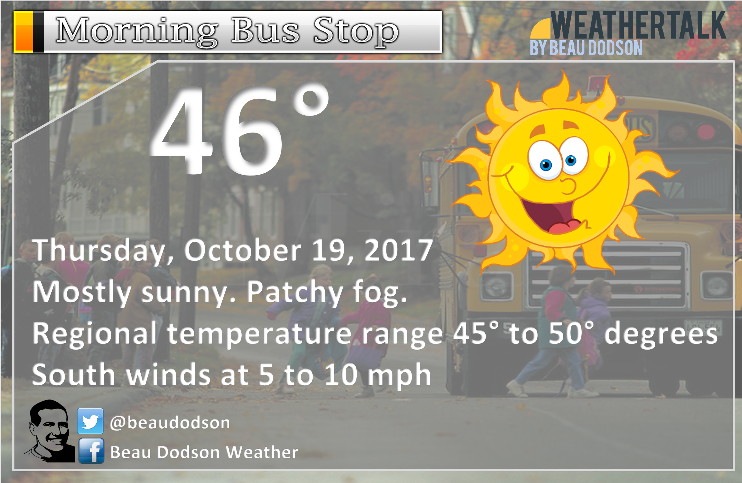
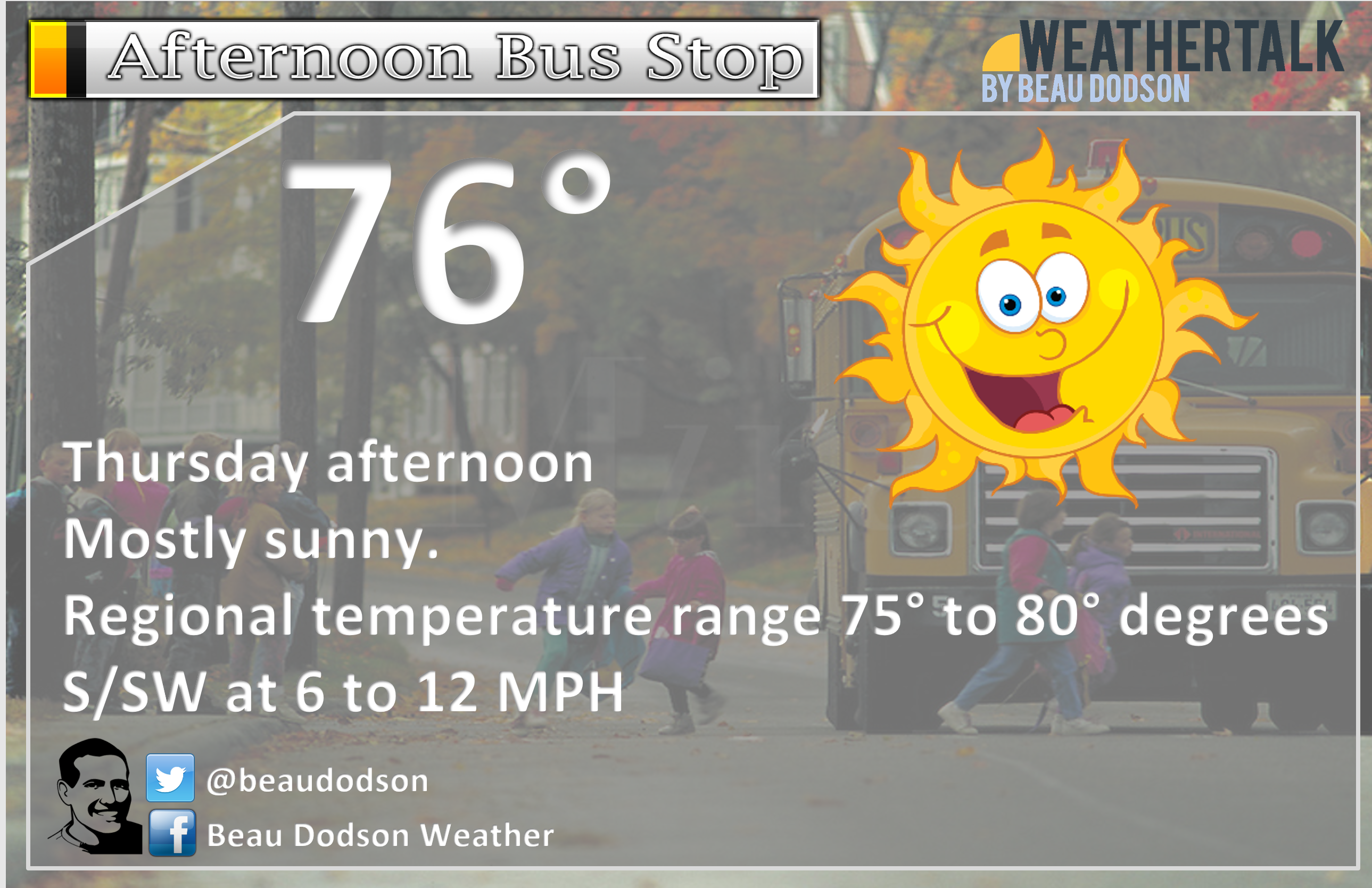
October 19, 2017
Thursday Forecast Details
Forecast: Mostly sunny. Pleasant.
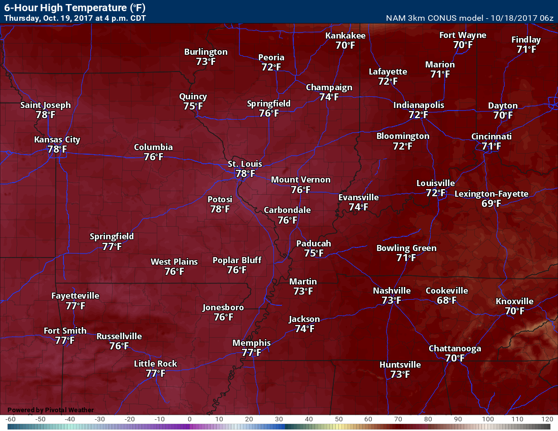
Temperatures: MO ~ 75 to 80 IL ~ 74 to 78 KY ~ 76 to 78
Winds: Southerly at 7 to 14 mph with gusts to 20 mph
What impacts are anticipated from the weather? None
My confidence in the forecast verifying: High
Is severe weather expected? No
The NWS defines severe weather as 58 mph winds or great, 1″ hail or larger, and/or tornadoes
What is the chance of precipitation? MO ~ 0% IL ~ 0% KY ~ 0%
Coverage of precipitation: None
Should I cancel my outdoor plans? No
.
Thursday Night Forecast Details:
Forecast: Mostly clear.
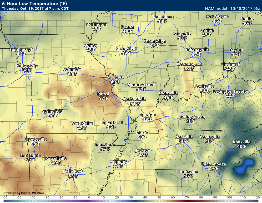
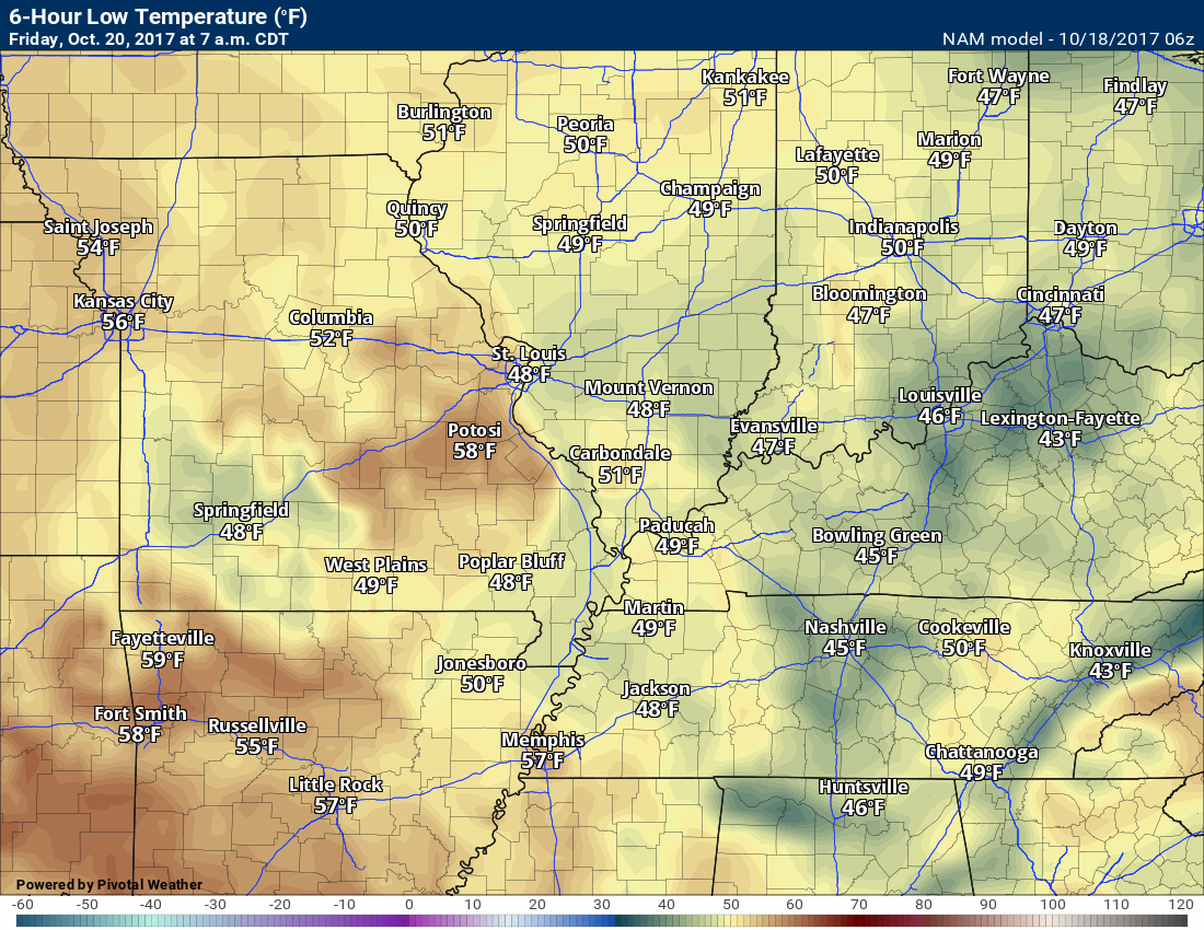
Temperatures: MO ~ 48 to 54 IL ~ 48 to 52 KY ~ 48 to 54
Winds: Southerly winds at 4 to 8 mph with gusts to 10 mph
What impacts are anticipated from the weather? None.
My confidence in the forecast verifying: High.
Is severe weather expected? No
The NWS defines severe weather as 58 mph winds or great, 1″ hail or larger, and/or tornadoes
What is the chance of precipitation? MO ~ 0% IL ~ 0% KY ~ 0%
Coverage of precipitation: None
Should I cancel my outdoor plans? No
.
October 20, 2017
Friday Forecast Details
Forecast: Partly sunny. Pleasant.
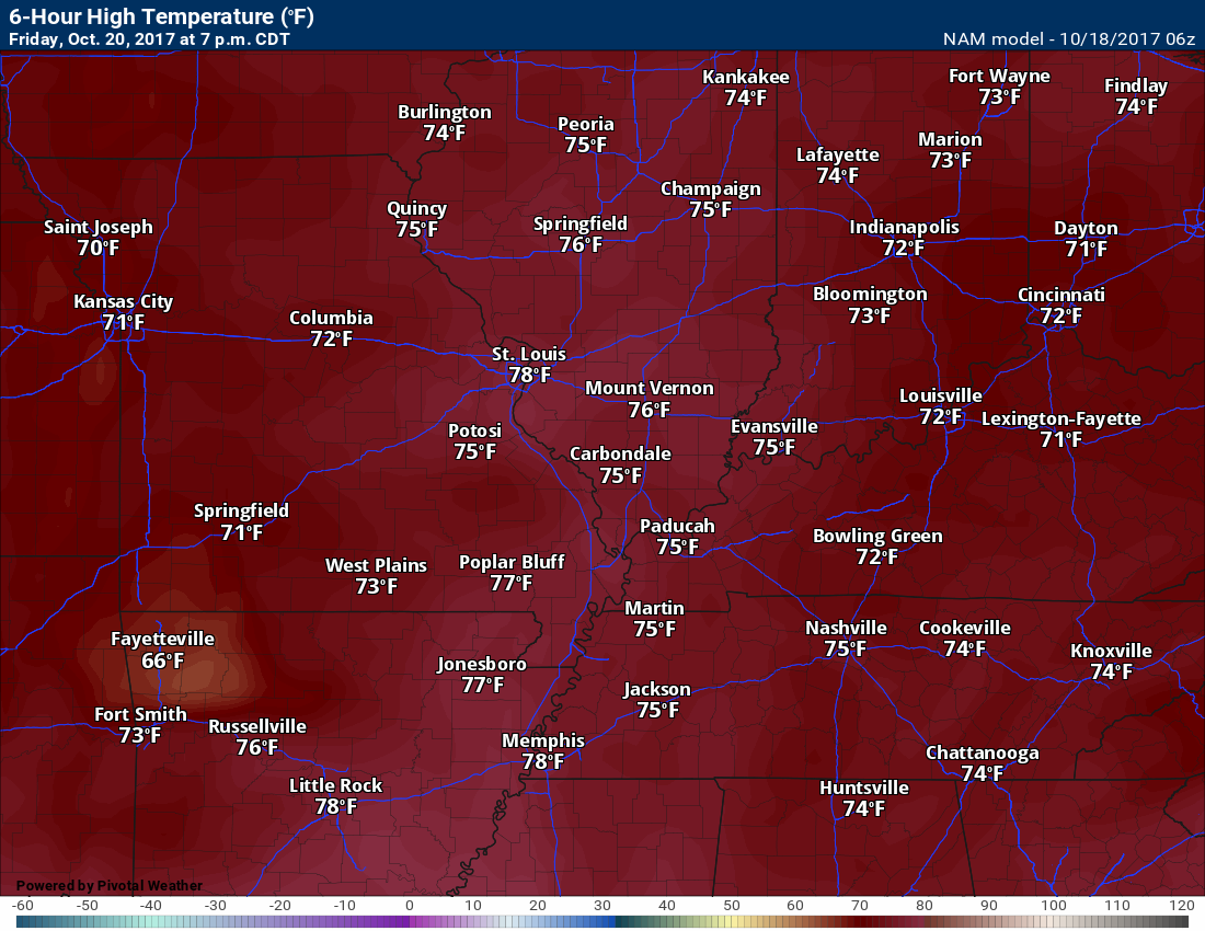
Temperatures: MO ~ 75 to 80 IL ~ 75 to 80 KY ~ 75 to 80
Winds: South at 5 to 10 mph with gusts to 12 mph
What impacts are anticipated from the weather? None
My confidence in the forecast verifying: High
Is severe weather expected? No
The NWS defines severe weather as 58 mph winds or great, 1″ hail or larger, and/or tornadoes
What is the chance of precipitation? MO ~ 0% IL ~ 0% KY ~ 0%
Coverage of precipitation: None
Should I cancel my outdoor plans? No
.
Friday Night Forecast Details:
Forecast: Partly cloudy.
Temperatures: MO ~ 54 to 58 IL ~ 54 to 58 KY ~ 54 to 58
Winds: Southerly winds at 6 to 12 mph increasing late.
What impacts are anticipated from the weather? None
My confidence in the forecast verifying: High
Is severe weather expected? No
The NWS defines severe weather as 58 mph winds or great, 1″ hail or larger, and/or tornadoes
What is the chance of precipitation? MO ~ 0% IL ~ 0% KY ~ 0%
Coverage of precipitation: None
Should I cancel my outdoor plans? No
.
October 21, 2017
Saturday Forecast Details
Forecast: A mix of sun and clouds. Lower confidence on cloud cover for Saturday. A chance for showers (monitor updates). Pleasant. Breezy.
Temperatures: MO ~ 76 to 82 IL ~ 76 to 82 KY ~ 76 to 82
Winds: South at 10 to 20 mph. Gusty winds.
What impacts are anticipated from the weather? Wet roadways.
My confidence in the forecast verifying: LOW
Is severe weather expected? No
The NWS defines severe weather as 58 mph winds or great, 1″ hail or larger, and/or tornadoes
What is the chance of precipitation? MO ~ 40% IL ~ 30% KY ~ 20%
Coverage of precipitation: Isolated to perhaps scattered. Greatest coverage might end up over southeast Missouri.
Should I cancel my outdoor plans? No, but check radars.
.
Saturay Night Forecast Details:
Forecast: Increasing clouds. Breezy. A few scattered showers before midnight. Increasing chances of showers after midnight. Timing of the front is still questionable.
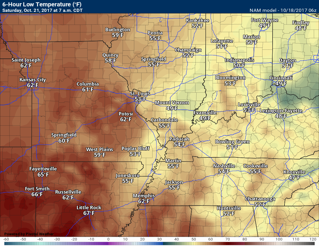
Temperatures: MO ~ 58 to 64 IL ~ 58 to 64 KY ~ 58 to 64
Winds: South winds at 7 to 14 mph with gusts to 25 mph
What impacts are anticipated from the weather? Wet roadways possible after midnight.
My confidence in the forecast verifying: Medium
Is severe weather expected? No
The NWS defines severe weather as 58 mph winds or great, 1″ hail or larger, and/or tornadoes
What is the chance of precipitation? MO ~ 50% IL ~ 50% KY ~ 30%
Coverage of precipitation: Perhaps scattered early. Increasing coverage late at night. Timing of the front is questionable. Increasing coverage after 3 am.
Should I cancel my outdoor plans? No
.
October 22, 2017
Sunday Forecast Details
Forecast: Cloudy. An 80% chance of showers and perhaps thunderstorms.
Temperatures: MO ~ 73 to 76 IL ~ 73 to 76 KY ~ 73 to 76
Winds: Southwest at 6 to 12 mph
What impacts are anticipated from the weather? Lightning and wet roadways.
My confidence in the forecast verifying: Medium
Is severe weather expected? Unlikely
The NWS defines severe weather as 58 mph winds or great, 1″ hail or larger, and/or tornadoes
What is the chance of precipitation? MO ~ 80% IL ~ 80% KY ~ 80%
Coverage of precipitation: Numerous
Should I cancel my outdoor plans? Monitor updates and have a plan B.
.
Sunday Night Forecast Details:
Forecast: Cloudy with rain showers possible.
Temperatures: MO ~ 52 to 56 IL ~ 52 to 56 KY ~ 54 to 58
Winds: West and northwest winds 6 to 12 mph
What impacts are anticipated from the weather? Wet roadways.
My confidence in the forecast verifying: Low
Is severe weather expected? No
The NWS defines severe weather as 58 mph winds or great, 1″ hail or larger, and/or tornadoes
What is the chance of precipitation? MO ~ 40% IL ~ 40% KY ~ 50%
Coverage of precipitation: Becoming scattered and then ending from west to east.
Should I cancel my outdoor plans? Have a plan B early in the night.
.
October 23, 2017
Monday Forecast Details
Forecast: A mix of sun and clouds. A shower possible. Lower confidence on Monday’s forecast. I will be monitoring a storm system to our south and east.
Temperatures: MO ~ 68 to 72 IL ~ 68 to 72 KY ~ 68 to 72
Winds: North and northeast winds at 6 to 12 mph
What impacts are anticipated from the weather? Wet roadways.
My confidence in the forecast verifying: LOW
Is severe weather expected? No
The NWS defines severe weather as 58 mph winds or great, 1″ hail or larger, and/or tornadoes
What is the chance of precipitation? MO ~ 30% IL ~ 30% KY ~ 40%
Coverage of precipitation:
Should I cancel my outdoor plans? Monitor updates .
.
Monday Night Forecast Details:
Forecast: Partly cloudy. A shower possible.
Temperatures: MO ~ 45 to 50 IL ~ 45 to 50 KY ~ 45 to 50
Winds: Northwest winds at 5 to 10 mph
What impacts are anticipated from the weather? Wet roadways.
My confidence in the forecast verifying: Low
Is severe weather expected? No
The NWS defines severe weather as 58 mph winds or great, 1″ hail or larger, and/or tornadoes
What is the chance of precipitation? MO ~ 20% IL ~ 20% KY ~ 30%
Coverage of precipitation:
Should I cancel my outdoor plans? Monitor updates
Thursday school bus stop forecast
Morning
Afternoon

The National Weather Service definition of a severe thunderstorm is one that produces quarter size hail or larger, 58 mph winds or greater, and/or a tornado.
Thursday night through next Saturday: Severe weather is not anticipated.
Thunderstorms are possible late Saturday night into Sunday night. Lightning is the main concern.
.

Highlights
- Great weather over the next couple of days
- Weekend cold front
- Cooler next week
The week ahead.
Quiet weather will be with us through Saturday. The weather becomes unsettled late Saturday night into Sunday.
High pressure has kept our region cool over the last few days. It is moving off to the east. That will mean a shift in winds. Winds will become southerly. This will mean a warming trend.
We might see an increase in clouds on Friday and Saturday. Guidance is mixed on this topic. I did include some mention of clouds in my forecast update. The amount of cloud coverage is the question.
We may have to deal with showers on Saturday. At one time it appeared that dry weather would rule, not so sure about that
Highs on Thursday into Saturday will range from 75 to 80 degrees. That is above the seasonal norms of 72 degrees (for high temperatures).
A cold front will arrive on Sunday.
A band of showers and perhaps thunderstorms will accompany the front. Rainfall totals of 0.30″ to 0.60″ will be possible. Guidance is showing heavier totals, but for now I went conservative.
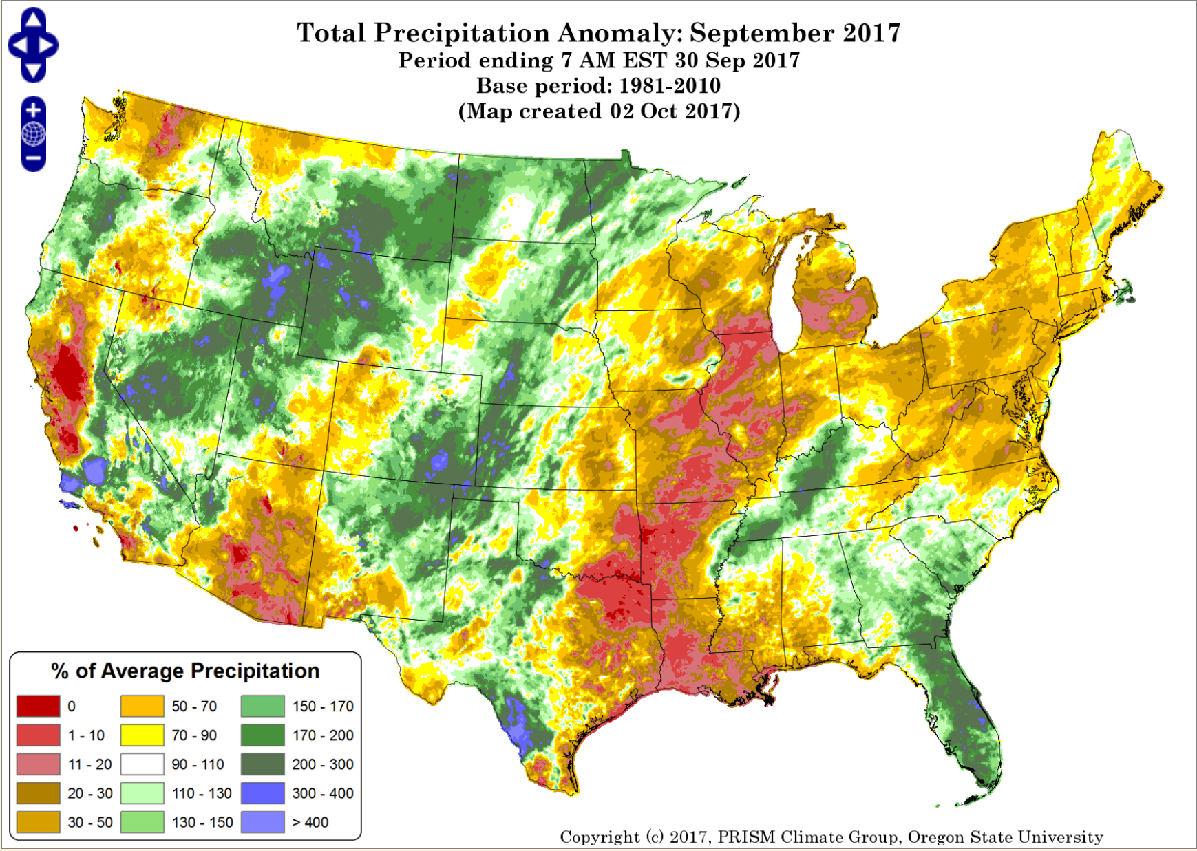
We do still need rain over portions of the area. Granted, a lot of rain fell over the last weeks (for some of you).
The September anomalies were high.
Here is the percent of normal precipitation for September. We will have to wait until the end of the month for the official October map.
September was obviously quite dry for many areas.
One fly in the forecast ointment is the Canadian model guidance. It is developing a stronger area of low pressure to our south on Sunday night and Monday. If this were January we would be talking about a major winter storm. It isn’t January!
If that system does form, then it could mean heavier rain totals. It would also mean rain lingering into Monday night. For now, I discounted the Canadian model, but I am closely watching trends.
Other models show this system, but not as strong and not as developed.
See the long range discussion/links further down in this post.
OCTOBER
If you thought October has been warm, then you would be correct.
Check out these stats. Each day in orange is an above normal temperature day. Each day in blue is a below normal temperature day. Obviously, we have had a very warm October. The numbers represent how many degrees above normal that day was.
These are some LARGE anomalies.
Normal high temperatures for this time of the year are around 70 to 74 degrees. Normal low temperatures are in the middle 40’s.
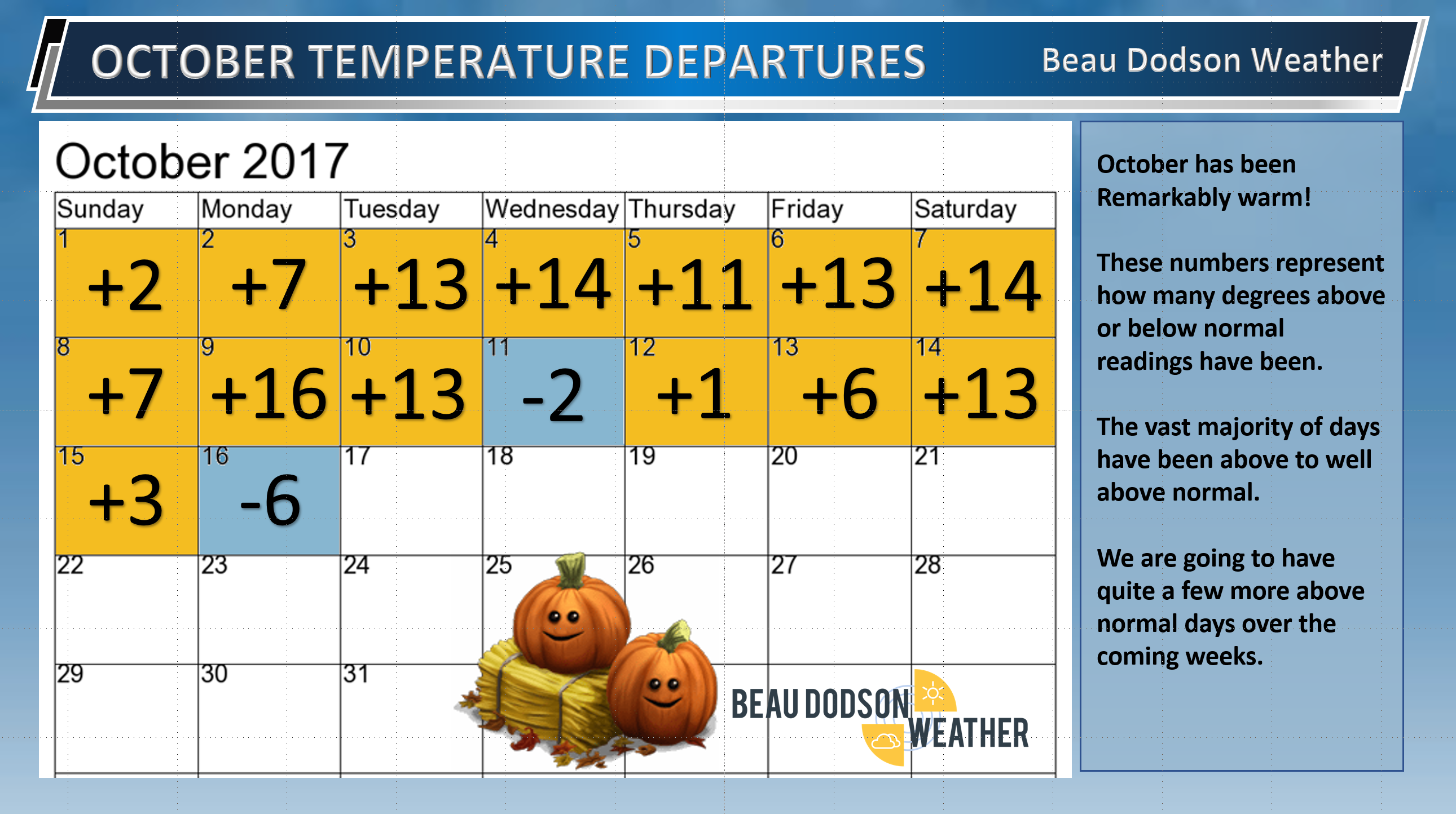
I will update that chart later this week.
Temperature Forecast
Wednesday night low temperature
Thursday high temperature
Thursday low temperatures
Friday high temperatures
Friday night low temperature
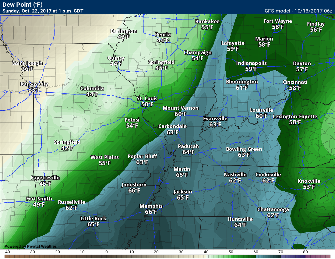
Dew point scale
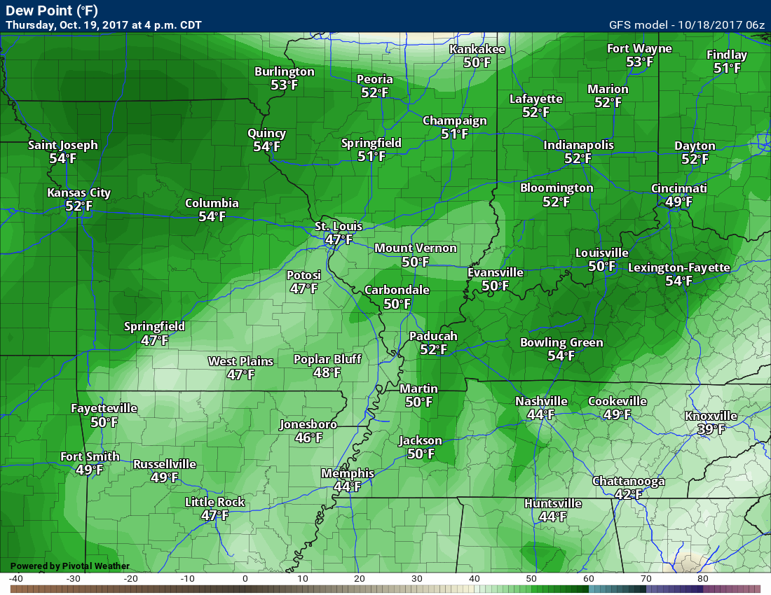
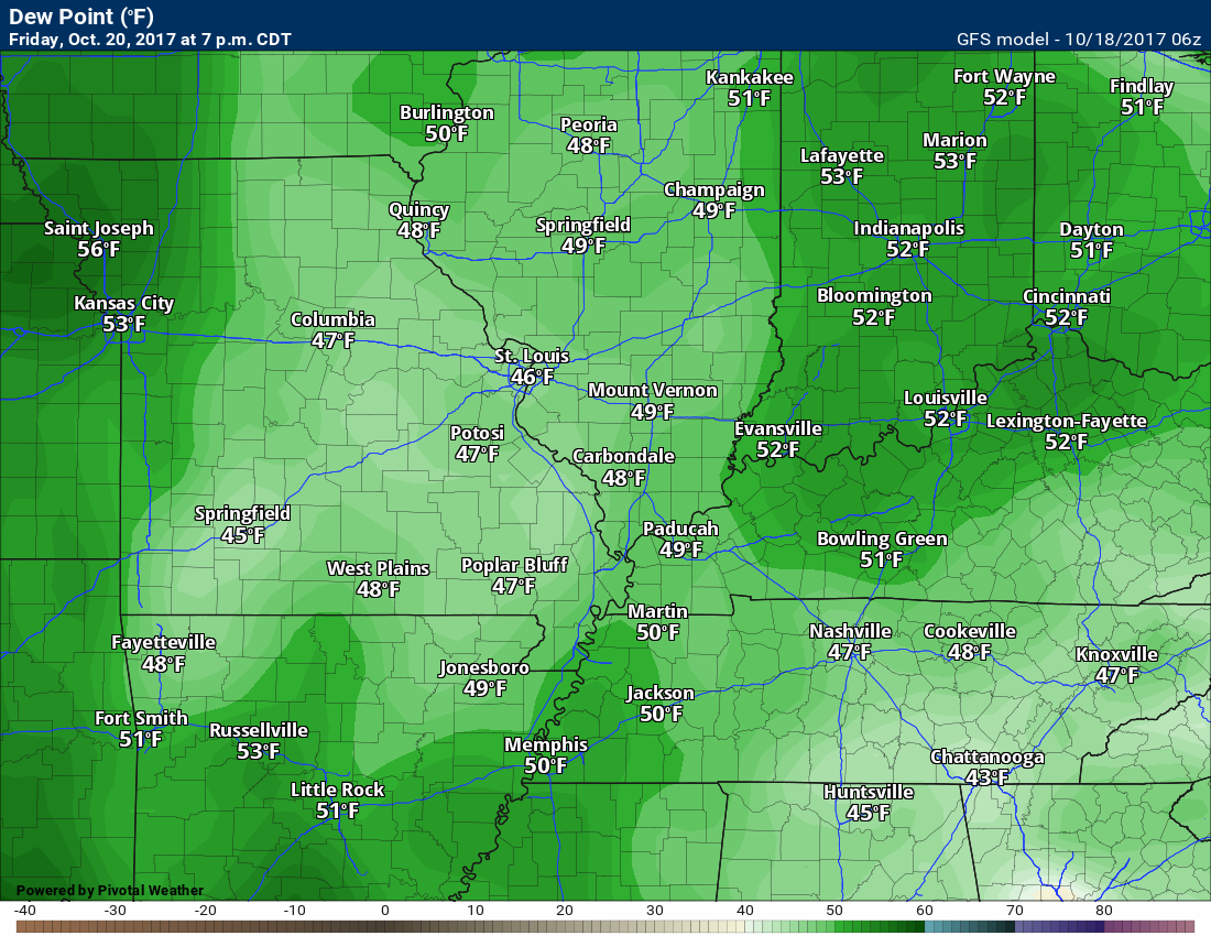
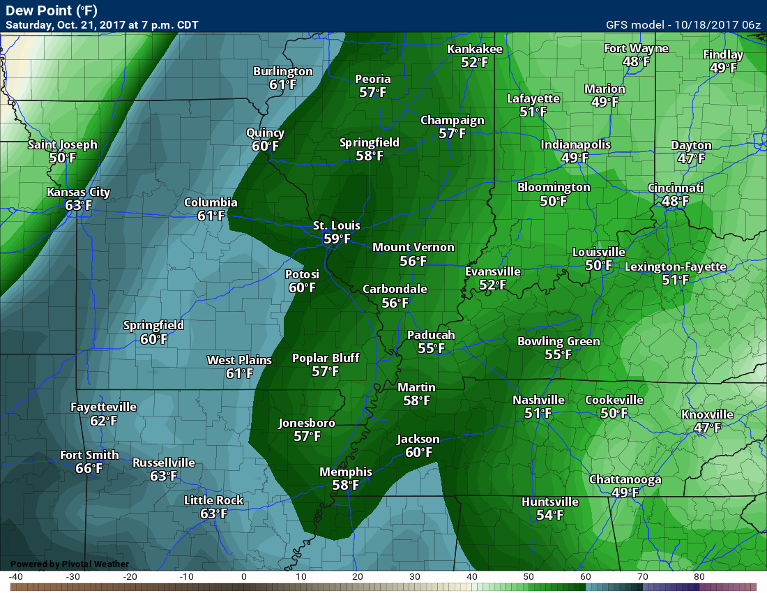
Dew points are what control how you feel outside.

Thursday dew points
Friday dew points
Saturday dew points
Sunday dew points
Long range forecast discussion
Dry weather is forecast Monday through Wednesday.
We may see colder temperatures next week with several days below normal.
View the long range discussion and video here ~ CLICK LONG RANGE LINK
Subscribers see the long range forecast/video on the Weather Talk page.
Subscriptions are $3 a month. This helps cover the $1000 to $2000 monthly costs.
Subscribe at www.beaudodsonweather.com
.
Are you subscribing to Weather Talk app/text messages and videos? This is what helps support all of the data you see each day.
We now offer premium videos for the short and long-range forecasts! These videos are produced by a team of long-range forecast experts. They are brought to you as bonus information. Activate text option four in order to receive these on your app or via text.
Subscribe at www.beaudodsonweather.com
We offer an Apple and Android app (scroll to the bottom of this page for more information).

Were you aware that I hired a team of meteorologists for long range videos?
To learn more, click this link
http://cms.weathertalk.com/meet-the-team/
.


We offer regional radars and local city radars – if a radar does not update then try another one. Occasional browsers need their cache cleared. You may also try restarting your browser. This will usually fix any problems.
During the winter you can track snow and ice by clicking the winterize button on the local city view interactive radars.
You may email me at beaudodson@usawx.com
Interactive Weather Radar Page. Choose the city nearest your location: Click this link
National interactive radar: Click this link.
The Beau Dodson Weather APP is ready for Apple and Android users. The app provides a faster way for you to receive my text messages. ATT and Verizon are not always reliable when it comes to speed.
Some of you have asked if you can receive the texts on your phone and the app. The answer to that is, yes. The Android app will automatically allow that to happen. On the Apple app, however, you will need to open your app and click the settings button. Make sure the green tab is OFF. Off means you will still receive the texts to your phone and the app. If you have any questions, then email me at beaudodson@usawx.com
The app is for text subscribers.
The direct download, for the Apple app, can be viewed here
https://itunes.apple.com/us/app/id1190136514
Here is the download link for the Android version Click Here
If you have not signed up for the texting service then you may do so at www.beaudodsonweather.com


——————————————————–
Your support helps with the following:

and

.

Whom do you trust for your weather information?
I have studied weather, in our region, since the late 1970’s. I have 40 years of experience in observing our regions weather patterns. My degree is in Broadcast Meteorology and a Bachelor’s of Science.
My resume includes:
Member of the American Meteorological Society.
NOAA Weather-Ready Nation Ambassador.
Meteorologist for McCracken County Emergency Management. I served from 2005 through 2015.
Meteorologist for McCracken County Rescue. 2015 through current
I own and operate the Southern Illinois Weather Observatory.
I am the chief meteorologist for Weather Talk LLC.
I am also a business owner in western Kentucky.
Recipient of the Mark Trail Award, WPSD Six Who Make A Difference Award, Kentucky Colonel, and the Caesar J. Fiamma” Award from the American Red Cross.
In 2005, I helped open the largest American Cross shelter in U.S. history. This was in Houston, Texas. I was deployed to help with the aftermath of Hurricane Katrina and Hurricane Rita. I was a shelter manager of one of the Houston, Texas shelter divisions.
In 2009 I was presented with the Kentucky Office of Highway Safety Award.
Recognized by the Kentucky House of Representatives for my service to the State of Kentucky leading up to several winter storms and severe weather outbreaks.
If you click on the image below you can read the Kentucky House of Representatives Resolution.

I am President of the Shadow Angel Foundation which serves portions of western Kentucky and southern Illinois.
There is a lot of noise on the internet. A lot of weather maps are posted without explanation. You need a trusted source for information.
My forecast philosophy is simple and straight forward.
- Communicate in simple terms
- To be as accurate as possible within a reasonable time frame before an event
- Interact with you on Twitter, Facebook, email, texts, and this blog
- Minimize the “hype” that you might see through other weather sources
- Push you towards utilizing wall-to-wall LOCAL TV coverage during severe weather events

Sign up for my AWARE email by clicking here.
I typically send AWARE emails before severe weather, winter storms, or other active weather situations. I do not email watches or warnings. The emails are a basic “heads up” concerning incoming weather conditions