WeatherTalk monthly operating costs can top $2000.00. Your $5 subscription helps pay for those costs. I work for you.
The $5 will allow you to register up to seven phones!
For $5 a month you can receive the following. You may choose to receive these via your WeatherTalk app or regular text messaging.
Severe weather app/text alerts from my keyboard to your app/cell phone. These are hand typed messages from me to you. During tornado outbreaks, you will receive numerous app/text messages telling you exactly where the tornado is located.
- Daily forecast app/texts from my computer to your app/cell phone.
- Social media links sent directly to your app/cell phone. When I update the blog, videos, or Facebook you will receive the link.
- AWARE emails. These emails keep you well ahead of the storm. They give you several days of lead time before significant weather events.
- Direct access to Beau via text and email. Your very own personal meteorologist. I work for you!
- Missouri and Ohio Valley centered video updates
- Long-range weather videos
- Week one, two, three and four temperature and precipitation outlooks.
Monthly outlooks. - Your subscription also will help support several local charities.
Would you like to subscribe? Subscribe at www.beaudodsonweather.com
Typical progression on a severe weather day for subscribers.


I encourage subscribers to use the app vs regular text messaging. We have found text messaging to be delayed during severe weather. The app typically will receive the messages instantly. I recommend people have three to four methods of receiving their severe weather information.
Remember, my app and text alerts are hand typed and not computer generated. You are being given my personal attention during significant weather events.

WWW.WEATHERTALK.COM subscribers, here is my day to day schedule for your weather products.
These are bonus videos and maps for subscribers. I bring these to you from the BAMwx team. I pay them to help with videos.
The Ohio and Missouri Valley videos cover most of our area. They do not have a specific Tennessee Valley forecast but may add one in the future.
The long-range video is technical. Over time, you can learn a lot about meteorology from the long range video. Just keep in mind, it is a bit more technical.


.
![]()

October 17, 2018
Wednesday forecast: Patchy morning fog and frost. Mostly sunny. A band of clouds may push across the area during the afternoon hours. We should remain dry through the day.
Temperatures: MO ~ 58 to 65 IL ~ 58 to 64 KY ~ 63 to 66 TN ~ 63 to 66
What is the chance of precipitation? MO ~ 0% IL ~ 0% KY ~ 0% TN ~ 0%
Coverage of precipitation: None
Wind: North and northeast at 8 to 16 mph. Winds may be gusty later today.
What impacts are anticipated from the weather? Morning low visibility in fog. Morning patchy frost.
My confidence in the forecast verifying: High
Is severe weather expected? No
The NWS defines severe weather as 58 mph wind or great, 1″ hail or larger, and/or tornadoes
Should I cancel my outdoor plans? No
UV Index: 5 Moderate
Sunrise: 7:05 AM
Wednesday Night Forecast Details:
Forecast: Partly cloudy. Cold. Frost possible. Patchy fog possible.
Temperatures: MO ~ 35 to 38 IL ~ 34 to 38 KY ~ 36 to 42 TN ~ 38 to 44
What is the chance of precipitation? MO ~ 0% IL ~ 0% KY ~ 0% TN ~ 0%
Coverage of precipitation: None
Frost Risk: Medium Highest chances across the northern half of southeast Missouri and along and north of a line from Cape Girardeau, Missouri, to Pope County, Illinois, and then northeast towards Owensboro. South of there should monitor updates. A frost advisory is possible for portions of the region.
Wind: North and northeast at 3 to 6 mph
What impacts are anticipated from the weather? Frost possible. Monitor updates if you have plants that are sensitive to frost.
My confidence in the forecast verifying: Medium
Is severe weather expected? No
The NWS defines severe weather as 58 mph wind or great, 1″ hail or larger, and/or tornadoes
Should I cancel my outdoor plans? No
Sunset: 6:15 PM
Moonrise: 2:46 PM First Quarter
Moonset: 12:10 AM
October 18, 2018
Thursday forecast: Partly to mostly sunny during the morning. Increasing clouds through the day. A bit cooler.
Temperatures: MO ~ 55 to 60 IL ~ 55 to 60 KY ~ 58 to 62 TN ~ 58 to 62
What is the chance of precipitation? MO ~ 0% IL ~ 0% KY ~ 0% TN ~ 0%
Coverage of precipitation: None
Wind: Northeast wind 5 to 10 mph with gusts to 12 mph
What impacts are anticipated from the weather? None
My confidence in the forecast verifying: High
Is severe weather expected? No
The NWS defines severe weather as 58 mph wind or great, 1″ hail or larger, and/or tornadoes
Should I cancel my outdoor plans? No
UV Index: 5 Moderate
Sunrise: 7:06 AM
Thursday Night Forecast Details:
Forecast: Increasing clouds overnight.
Temperatures: MO ~ 38 to 44 IL ~ 38 to 44 KY ~ 38 to 44 TN ~ 40 to 44
What is the chance of precipitation? MO ~ 10% IL ~ 0% KY ~ 0% TN ~ 0%
Coverage of precipitation: Most likely none
Frost Risk: Unlikely
Wind: Variable wind at 3 to 6 mph
What impacts are anticipated from the weather? Most likely none
My confidence in the forecast verifying: High
Is severe weather expected? No
The NWS defines severe weather as 58 mph wind or great, 1″ hail or larger, and/or tornadoes
Should I cancel my outdoor plans? No
Sunset: 6:14 PM
Moonrise: 3:24 PM Waxing Gibbous
Moonset: 1:01 AM
October 19, 2018
Friday forecast: Mostly cloudy. A band of showers will push across the area from west to east. The most likely time frame would be the afternoon and evening hours. It is possible that most of Friday morning remains dry.
Temperatures: MO ~ 54 to 58 IL ~ 55 to 58 KY ~ 56 to 58 TN ~ 58 to 62
What is the chance of precipitation? MO ~ 60% IL ~ 60% KY ~ 60% TN ~ 60%
Coverage of precipitation: Becoming numerous
Wind: South and southwest at 6 to 12 mph
What impacts are anticipated from the weather? Wet roadways.
My confidence in the forecast verifying: Medium
Is severe weather expected? No
The NWS defines severe weather as 58 mph wind or great, 1″ hail or larger, and/or tornadoes
Should I cancel my outdoor plans? Have a plan B. Rain is possible during the afternoon hours.
UV Index: 1 to 3 Low
Sunrise: 7:07 AM
Friday Night Forecast Details:
Forecast: Mostly cloudy. Showers possible before midnight. Diminishing chances late at night. Rain will end west to east. That means the rain will linger longer over the Pennyrile area of western Kentucky.
Temperatures: MO ~ 44 to 48 IL ~ 45 to 48 KY ~ 44 to 48 TN ~ 44 to 48
What is the chance of precipitation? MO ~ 40% IL ~ 50% KY ~ 50% to 60% TN ~ 50% to 60%
Coverage of precipitation: Numerous early. Rain ending from northwest to southeast overnight.
Frost Risk: None anticipated
Wind: Southwest becoming west/northwest at 5 to 10 mph
What impacts are anticipated from the weather? Wet roadways
My confidence in the forecast verifying: High
Is severe weather expected? No
The NWS defines severe weather as 58 mph wind or great, 1″ hail or larger, and/or tornadoes
Should I cancel my outdoor plans? Monitor updates. Rain is possible.
Sunset: 6:13 PM
Moonrise: 3:58 PM Waxing Gibbous
Moonset: 2:00 AM
October 20, 2018
Saturday forecast: Mostly sunny. A few passing clouds. Breezy, at times.
Temperatures: MO ~ 60 to 64 IL ~ 60 to 64 KY ~ 60 to 64 TN ~60 to 65
What is the chance of precipitation? MO ~ 0% IL ~ 0% KY ~ 0% TN ~ 0%
Coverage of precipitation: None
Wind: Northwest at 8 to 16 mph with gusts to 25 mph
What impacts are anticipated from the weather? None
My confidence in the forecast verifying: Medium to high
Is severe weather expected? No
The NWS defines severe weather as 58 mph wind or great, 1″ hail or larger, and/or tornadoes
Should I cancel my outdoor plans? No
UV Index: 5 Moderate
Sunrise: 7:08 AM
Saturday Night Forecast Details:
Forecast: Mostly clear. Chilly. Frost may be difficult to form because of windy conditions.
Temperatures: MO ~ 36 to 40 IL ~ 36 to 38 KY ~ 36 to 40 TN ~ 38 to 44
What is the chance of precipitation? MO ~ 0% IL ~ 0% KY ~ 0% TN ~ 0%
Coverage of precipitation: None
Frost Risk: Low
Wind: North at 5 to 10 mph
What impacts are anticipated from the weather? None (I will monitor the fog and frost portion of the forecast)
My confidence in the forecast verifying: High
Is severe weather expected? No
The NWS defines severe weather as 58 mph wind or great, 1″ hail or larger, and/or tornadoes
Should I cancel my outdoor plans? No
Sunset: 6:11 PM
Moonrise: 4:30 PM Waxing Gibbous
Moonset: 2:57 AM
October 21, 2018
Sunday forecast: Mostly sunny. A few passing clouds. Cool.
Temperatures: MO ~ 512 to 55 IL ~ 52 to 55 KY ~ 53 to 56 TN ~53 to 56
What is the chance of precipitation? MO ~ 0% IL ~ 0% KY ~ 0% TN ~ 0%
Coverage of precipitation: None
Wind: North and northeast at 5 to 10 mph with gusts to 15 mph
What impacts are anticipated from the weather? None
My confidence in the forecast verifying: High
Is severe weather expected? No
The NWS defines severe weather as 58 mph wind or great, 1″ hail or larger, and/or tornadoes
Should I cancel my outdoor plans? No
UV Index: 5 Moderate
Sunrise: 7:09 AM
Sunday Night Forecast Details:
Forecast: Mostly clear. Patchy fog possible. Frost likely.
Temperatures: MO ~ 34 to 38 IL ~ 34 to 38 KY ~ 34 to 38 TN ~ 35 to 40
What is the chance of precipitation? MO ~ 0% IL ~ 0% KY ~ 0% TN ~ 0%
Coverage of precipitation: None
Frost Risk: High
Wind: Variable wind at less than 5 mph
What impacts are anticipated from the weather? Frost likely. Monitor updates if you have plants that are sensitive to frost.
My confidence in the forecast verifying: Medium
Is severe weather expected? No
The NWS defines severe weather as 58 mph wind or great, 1″ hail or larger, and/or tornadoes
Should I cancel my outdoor plans? No
Sunset: 6:10 PM
Moonrise: 5:01 PM Waxing Gibbous
Moonset: 3:54 AM
October 22, 2018
Monday forecast: Mostly sunny.
Temperatures: MO ~ 55 to 60 IL ~ 55 to 60 KY ~ 55 to 60 TN ~ 55 to 60
What is the chance of precipitation? MO ~ 0% IL ~ 0% KY ~ 0% TN ~ 0%
Coverage of precipitation: None
Wind: South at 5 to 10 mph with gusts to 12 mph
What impacts are anticipated from the weather? None
My confidence in the forecast verifying: Medium
Is severe weather expected? No
The NWS defines severe weather as 58 mph wind or great, 1″ hail or larger, and/or tornadoes
Should I cancel my outdoor plans? No
UV Index: 5 Moderate
Sunrise: 7:10 AM
Monday Night Forecast Details:
Forecast: Intervals of clouds. Not as cold as previous nights.
Temperatures: MO ~ 40 to 45 IL ~ 40 to 45 KY ~ 40 to 45 TN ~ 40 to 45
What is the chance of precipitation? MO ~ 10% IL ~ 0% KY ~ 0% TN ~ 0%
Coverage of precipitation: None
Frost Risk: None
Wind: South and southwest wind at 4 to 8 mph
What impacts are anticipated from the weather? None
My confidence in the forecast verifying: Medium
Is severe weather expected? No
The NWS defines severe weather as 58 mph wind or great, 1″ hail or larger, and/or tornadoes
Should I cancel my outdoor plans? No
Sunset: 6:09 PM
Moonrise: 5:31 PM Waxing Gibbous
Moonset: 4:54 AM
October 23, 2018
Tuesday forecast: Partly cloudy. Mild.
Temperatures: MO ~ 60 to 65 IL ~ 60 to 65 KY ~ 60 to 65 TN ~ 60 to 65
What is the chance of precipitation? MO ~ 10% IL ~ 0% KY ~ 0% TN ~ 0%
Coverage of precipitation: None
Wind: North and northeast at 5 to 10 mph
What impacts are anticipated from the weather? None
My confidence in the forecast verifying: Medium
Is severe weather expected? No
The NWS defines severe weather as 58 mph wind or great, 1″ hail or larger, and/or tornadoes
Should I cancel my outdoor plans? No
UV Index: 5 Moderate
Sunrise: 7:11 AM
Tuesday Night Forecast Details:
Forecast: Decreasing cloudiness. Cool temperatures.
Temperatures: MO ~ 38 to 42 IL ~ 38 to 42 KY ~ 40 to 44 TN ~ 40 to 44
What is the chance of precipitation? MO ~ 0% IL ~ 0% KY ~ 0% TN ~ 0%
Coverage of precipitation: None
Frost Risk: Unlikely
Wind: North at 6 to 12 mph
What impacts are anticipated from the weather? None
My confidence in the forecast verifying: Medium
Is severe weather expected? No
The NWS defines severe weather as 58 mph wind or great, 1″ hail or larger, and/or tornadoes
Should I cancel my outdoor plans? No
Sunset: 6:08 PM
Moonrise: 6:02 PM Waxing Gibbous
Moonset: 5:54 AM
October 24, 2018
Wednesday forecast: Partly cloudy. Cool.
Temperatures: MO ~ 58 to 64 IL ~ 58 to 64 KY ~ 58 to 64 TN ~ 58 to 64
What is the chance of precipitation? MO ~ 10% IL ~ 0% KY ~ 0% TN ~ 0%
Coverage of precipitation: None
Wind: North at 5 to 10 mph
What impacts are anticipated from the weather? None
My confidence in the forecast verifying: Medium
Is severe weather expected? No
The NWS defines severe weather as 58 mph wind or great, 1″ hail or larger, and/or tornadoes
Should I cancel my outdoor plans? No
UV Index: 5 Moderate
Sunrise: 7:12 AM
Wednesday Night Forecast Details:
Forecast: Mostly clear. Cool.
Temperatures: MO ~ 48 to 54 IL ~ 48 to 54 KY ~ 48 to 54 TN ~ 48 to 54
What is the chance of precipitation? MO ~ 0% IL ~ 0% KY ~ 0% TN ~ 0%
Coverage of precipitation: None
Frost Risk: No
Wind: East and northeast at 6 to 12 mph
What impacts are anticipated from the weather? None
My confidence in the forecast verifying: Medium
Is severe weather expected? No
The NWS defines severe weather as 58 mph wind or great, 1″ hail or larger, and/or tornadoes
Should I cancel my outdoor plans? No
Sunset: 6:06 PM
Moonrise: 6:34 PM Full
Moonset: 6:56 AM
October 25, 2018
Thursday forecast: Mostly sunny.
Temperatures: MO ~ 66 to 72 IL ~ 66 to 72 KY ~ 66 to 72 TN ~ 66 to 72
What is the chance of precipitation? MO ~ 10% IL ~ 0% KY ~ 0% TN ~ 0%
Coverage of precipitation: None
Wind: East and southeast at 5 to 10 mph
What impacts are anticipated from the weather? None
My confidence in the forecast verifying: Low
Is severe weather expected? No
The NWS defines severe weather as 58 mph wind or great, 1″ hail or larger, and/or tornadoes
Should I cancel my outdoor plans? No
UV Index: 4 Moderate
Sunrise: 7:13 AM
Thursday Night Forecast Details:
Forecast: Partly cloudy.
Temperatures: MO ~ 50 to 55 IL ~ 50 to 55 KY ~ 50 to 55 TN ~ 50 to 55
What is the chance of precipitation? MO ~ 0% IL ~ 0% KY ~ 0% TN ~ 0%
Coverage of precipitation: None
Frost Risk: None
Wind: Southeast at 5 to 10 mph
What impacts are anticipated from the weather? None
My confidence in the forecast verifying: Low
Is severe weather expected? No
The NWS defines severe weather as 58 mph wind or great, 1″ hail or larger, and/or tornadoes
Should I cancel my outdoor plans? No
Sunset: 6:05 PM
Moonrise: 7:09 PM Waning Gibbous
Moonset: 7:59 AM
Learn more about the UV index readings. Click here.
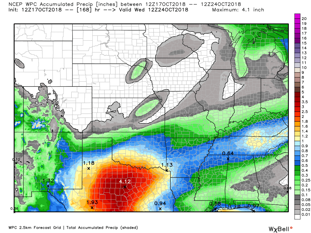
 Here is the latest WPC/NOAA rainfall outlook.
Click to enlarge.
This is today through next Monday night.
Most of this falls late Thursday night into Friday night.
Did you know that you can find me on Twitter?

Need a forecast for an outdoor event?


We offer interactive local city live radars and regional radars.
If a radar does not update then try another one. If a radar does not appear to be refreshing then hit Ctrl F5 on your keyboard.
You may also try restarting your browser. The local city view radars also have clickable warnings.
During the winter months, you can track snow and ice by clicking the winterize button on the local city view interactive radars.

Questions? Broken links? Other questions?
You may email me at beaudodson@usawx.com

The National Weather Service defines a severe thunderstorm as one that produces quarter size hail or larger, 58 mph winds or greater, and/or a tornado.
Today through next Wednesday: Severe weather is not anticipated.
Interactive live weather radar page. Choose the city nearest your location. If one of the cities does not work then try a nearby one. Click here.
National map of weather watches and warnings. Click here.
Storm Prediction Center. Click here.
Weather Prediction Center. Click here.

Live lightning data: Click here.

Interactive GOES R satellite. Track clouds. Click here.

Here are the latest local river stage forecast numbers Click Here.
Here are the latest lake stage forecast numbers for Kentucky Lake and Lake Barkley Click Here.

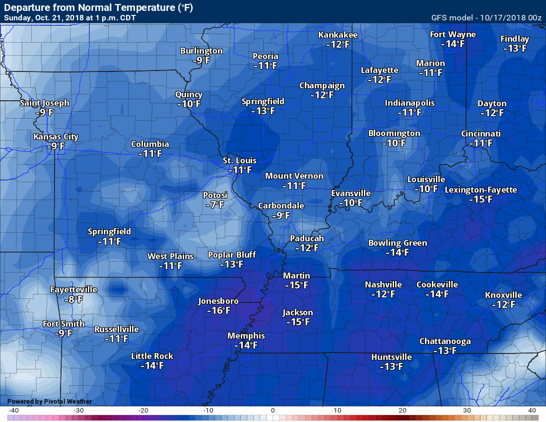
- Below normal temperatures to continue well into next week
- A rain event is likely Friday and Friday night
- Frost chances tonight and then again Saturday and Sunday night
- Sunday night might be the coldest night of the season, thus far
I am headed to Key Largo today. My nephew is getting married. Congratulations Dylan and Kaitlyn. I wish you many years of happiness.
A nice day ahead of us.
There is some morning fog and patchy frost in the region. Use care in the foggy areas.
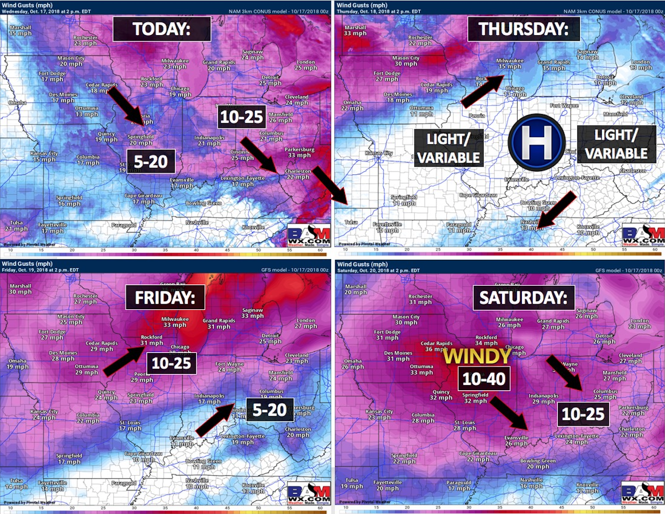
Winds may pick up over the coming days.
Here is the wind forecast graphic.
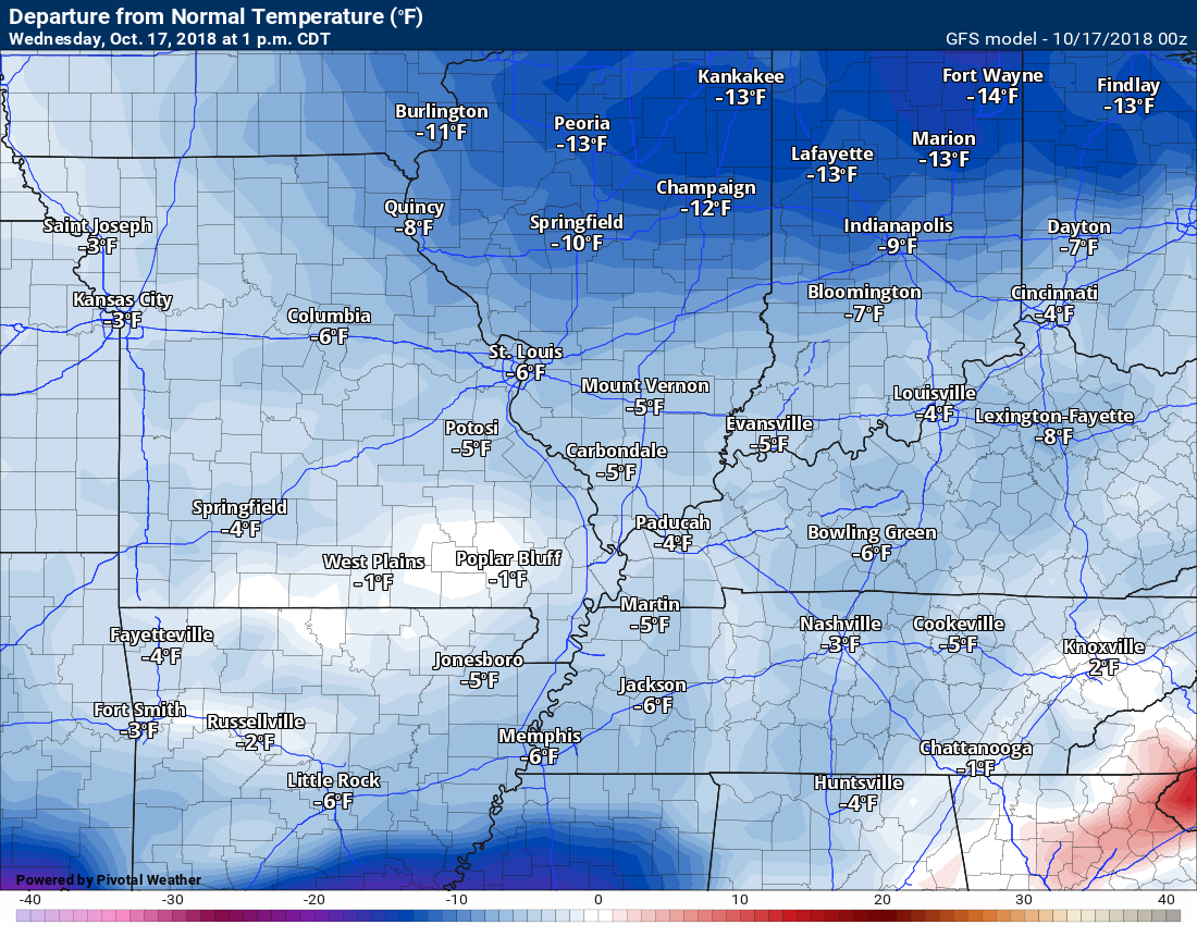
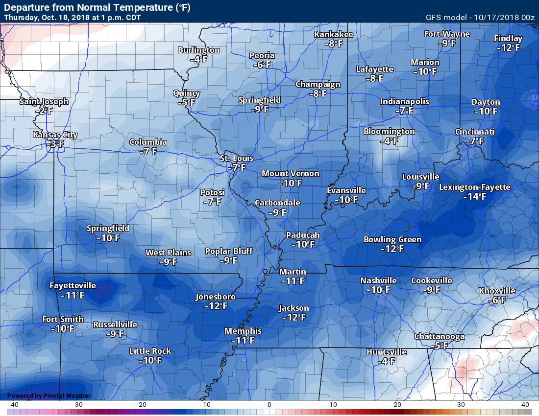
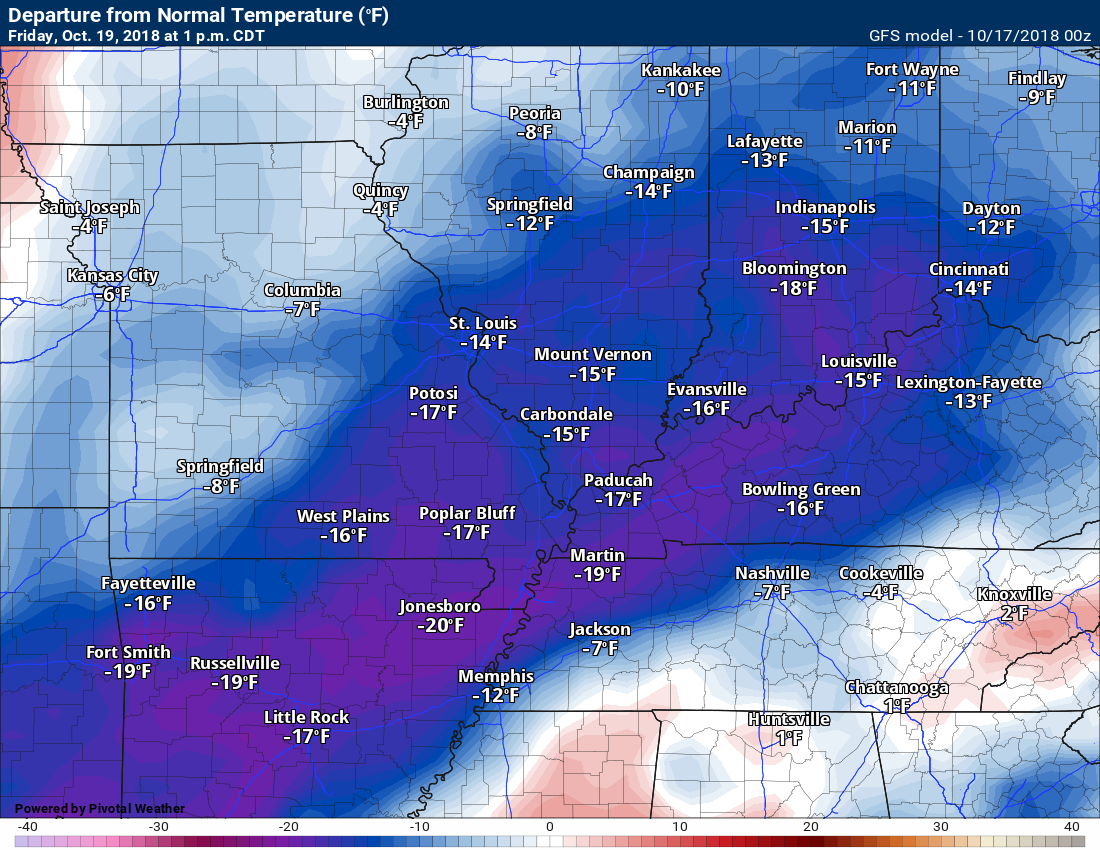
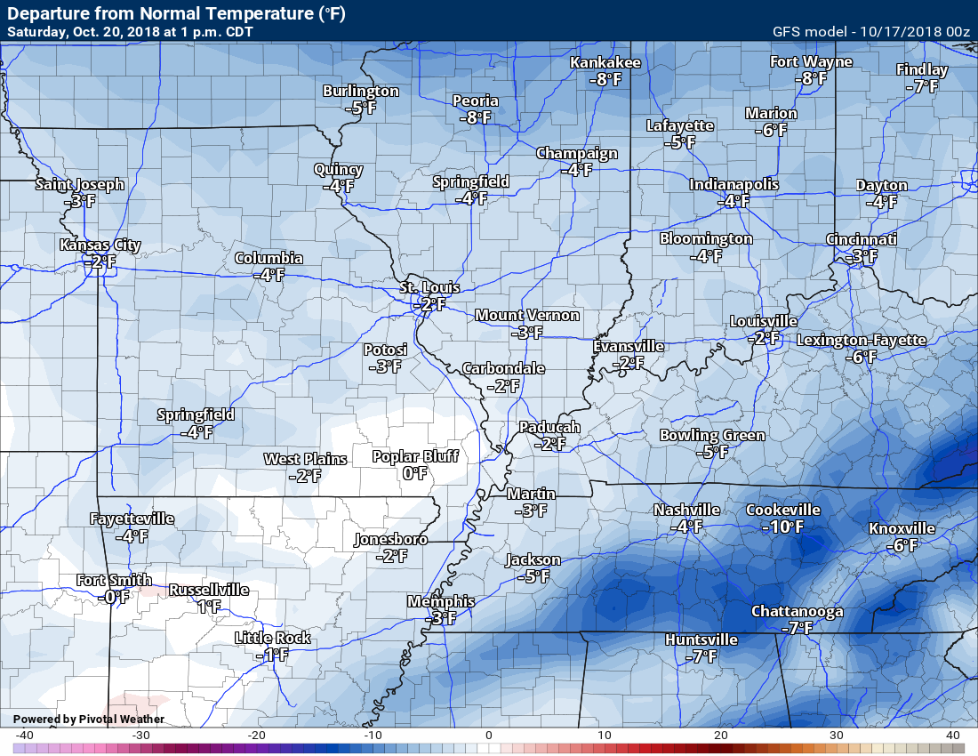
We have more cool weather on the way for the region. It won’t be bitterly cold, but it will certainly be cooler than it should be.
Wednesday 1 PM temperature anomalies
This shows you how many degrees above or below normal temperatures are expected to be.
Normal high temperatures are around 74 degrees.
Thursday 1 PM temperature anomalies
Friday 1 PM temperature anomalies
Saturday 1 PM temperature anomalies
Sunday 1 PM temperature anomalies
Monday 1 PM temperature anomalies
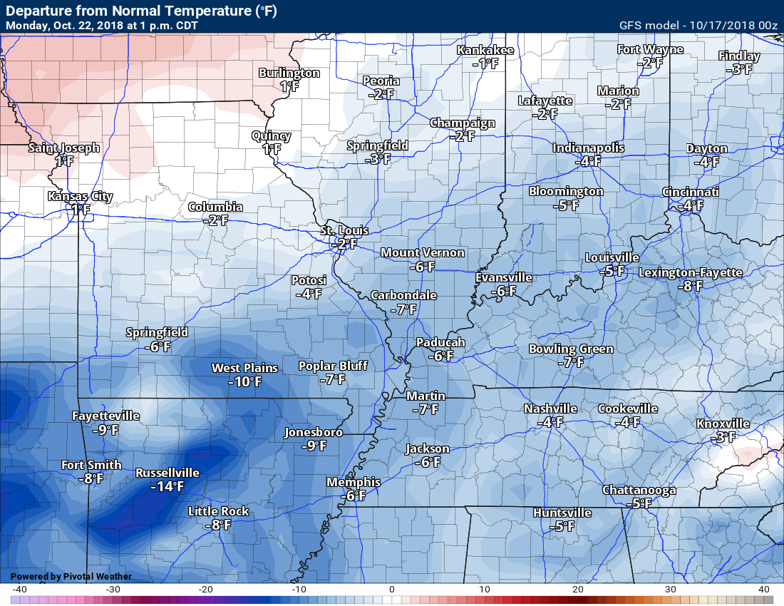
A nice streak of below normal days. We had plenty of warm weather earlier in the month. I guess we knew that couldn’t last forever.
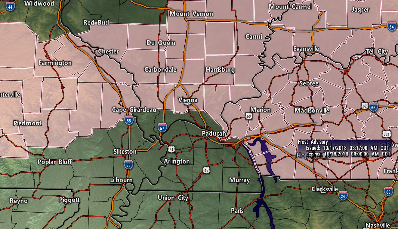
Frost?
I am monitoring frost chances tonight into Thursday morning.
The greatest risk of frost will extend from Cape Girardeau, Missouri, and then eastward towards Pope County, Illinois, and then northeast towards Owensboro.
There could be frost south of that line, as well. The greatest risk will be north of that line.
A frost advisory has been issued by the NWS for tonight. Pink zone.
I will keep an eye on the other counties bordering it, as well.
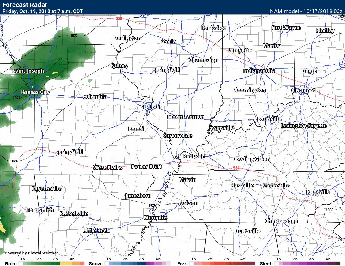
Friday’s Rain Event
The next big topic will be rain showers Friday into Friday night.
It appears that a widespread rain event is likely. At this time, it does not appear that the rain will be heavy.
A cold front will push into the region Friday afternoon and night. The rain will push across the region from west to east.
The rain will taper off Friday night.
Here is the NAM model guidance. See the time-stamp at the top? Check that for the NAM’s timing of the rain.
Model guidance is within six hours of each other. What does that mean? It means that the models don’t exactly agree on the arrival time of the rain. They are, however, within six hours of each other.
I know some of you have outdoor events. Monitor the timing of the rain. Plain on rain on radar Friday.
Dry weekend with frost chances
Saturday and Sunday should be dry.
Gusty winds are possible Saturday. That will make it feel a bit cooler.
Frost chances ramp up Saturday and especially Sunday night. Sunday night could be the coldest night of the season, thus far.
Halloween
I am monitoring a cold front around Halloween. That could bring a cold snap, as well. Perhaps the coldest air of the season.
![]()
Click to enlarge this graphic.
.
![]()
The September forecast has been updated.
![]()

I bring these to you from the BAMwx team. They are excellent long-range forecasters.
Remember, long-range outlooks are a bit of skill, understanding weather patterns, and luck combined. It is not an exact science.

This product is for subscribers.
Subscribe at www.weathertalk.com
Subscriber graphics can be viewed on this page CLICK HERE

This product is for subscribers.

This product is for subscribers.
Subscribe at www.weathertalk.com
Subscriber graphics can be viewed on this page CLICK HERE
![]()
.
Fall Outlook!
Preliminary October precipitation outlook
.
Here is the preliminary November temperature and precipitation outlook
.
Preliminary November temperature outlook
Preliminary November precipitation outlook
.These products are for subscribers.
![]()

A new weather podcast is now available! Weather Geeks (which you might remember is on The Weather Channel each Sunday)
To learn more visit their website. Click here.
![]()

WeatherBrains Episode 664
This week’s Guest WeatherBrain is an Assistant Professor in the Mechanical and Aerospace Engineering School at Oklahoma State University. Brian Elbing, welcome to WeatherBrains!
Other discussions in this weekly podcast include topics like:
- James describes his experiences witnessing and hearing tornadoes in person
- Strengthening Hurricane Michael heads toward the Florida Panhandle
- Snowfall in Colorado
- Highly amplified pattern across the United States
- Tornado activity across Iowa
- Astronomy Outlook with Tony Rice
- and more!
Link to their website https://weatherbrains.com/
Previous episodes can be viewed by clicking here.

We offer interactive local city live radars and regional radars. If a radar does not update then try another one. If a radar does not appear to be refreshing then hit Ctrl F5. You may also try restarting your browser.
The local city view radars also have clickable warnings.
During the winter months, you can track snow and ice by clicking the winterize button on the local city view interactive radars.
You may email me at beaudodson@usawx.com
Find me on Facebook!

Find me on Twitter!

Did you know that a portion of your monthly subscription helps support local charity projects?
You can learn more about those projects by visiting the Shadow Angel Foundation website and the Beau Dodson News website.

I encourage subscribers to use the app vs regular text messaging. We have found text messaging to be delayed during severe weather. The app typically will receive the messages instantly. I recommend people have three to four methods of receiving their severe weather information.
Remember, my app and text alerts are hand typed and not computer generated. You are being given personal attention during significant weather events.
