

.
A Weather Talk subscription ($3 a month) is required to view the videos.
Videos are posted on the www.weathertalk.com website. Once there, click the Beau Video-Cast tab. Long Range Video Update
If you believe you missed a video then you may check the LIVE FEED link on the Weather Talk website. You will find an archive of videos on that page.
You can also receive the videos via your Weather Talk app/text messages. Have text option FOUR activated. The Weather Extra text option. Sign up for the app/text messages, videos, and more at www.beaudodsonweather.com
.
This forecast covers the counties in red. The counties in orange are covered by the forecast discussion further down in the blog.


.
October 12, 2017
Thursday Night Forecast Details:
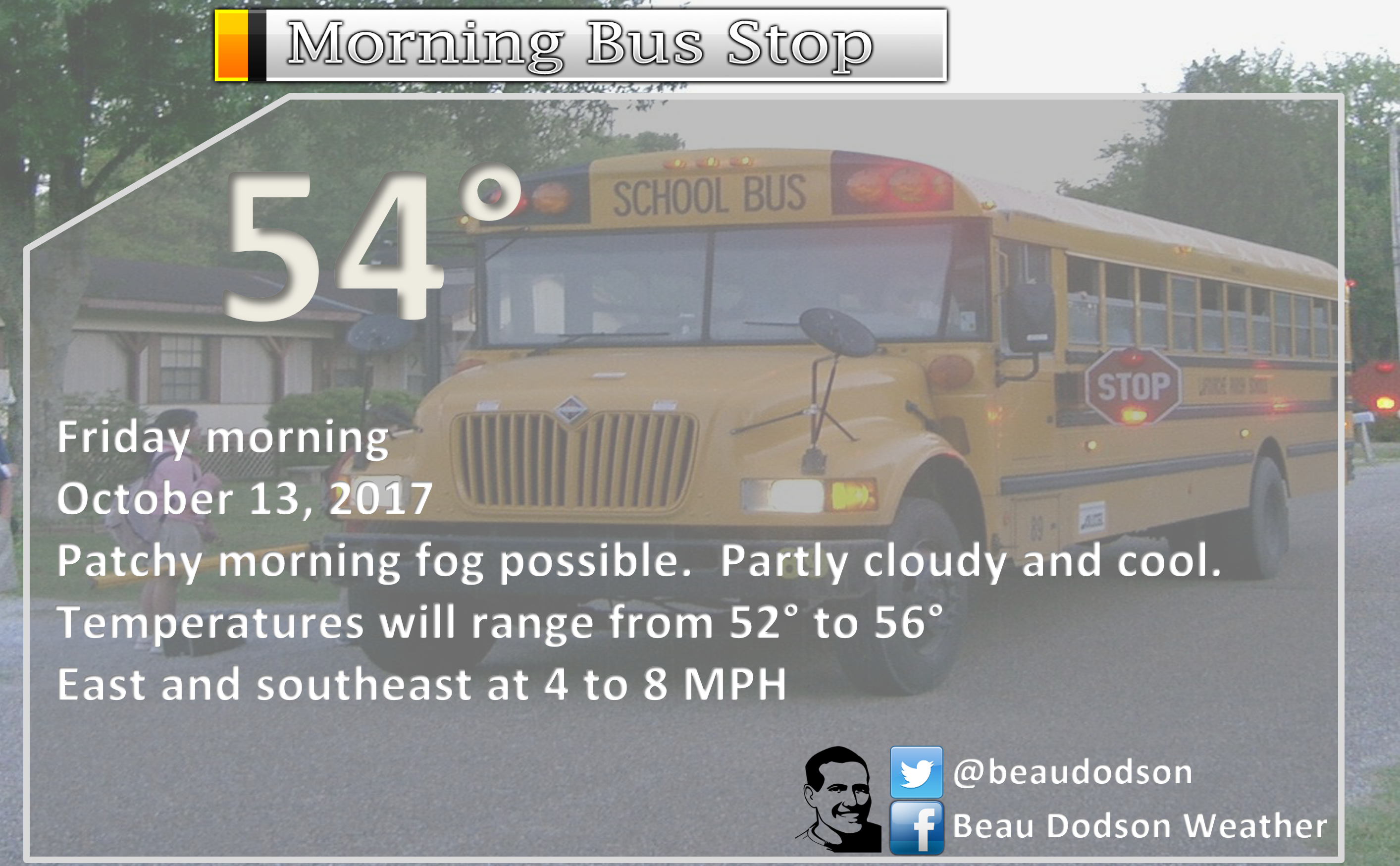
Forecast: Mostly clear and cool. Patchy fog possible.
Temperatures: MO ~ 50 to 55 IL ~ 50 to 55 KY ~ 52 to 55
Winds: Variable winds at 0 to 5 mph.
What impacts are anticipated from the weather? Perhaps patchy fog with lower visibility.
My confidence in the forecast verifying: High
Is severe weather expected? No
The NWS defines severe weather as 58 mph winds or great, 1″ hail or larger, and/or tornadoes
What is the chance of precipitation? MO ~ 0% IL ~ 0% KY ~ 0%
Coverage of precipitation: None
Should I cancel my outdoor plans? No
.
October 13, 2017
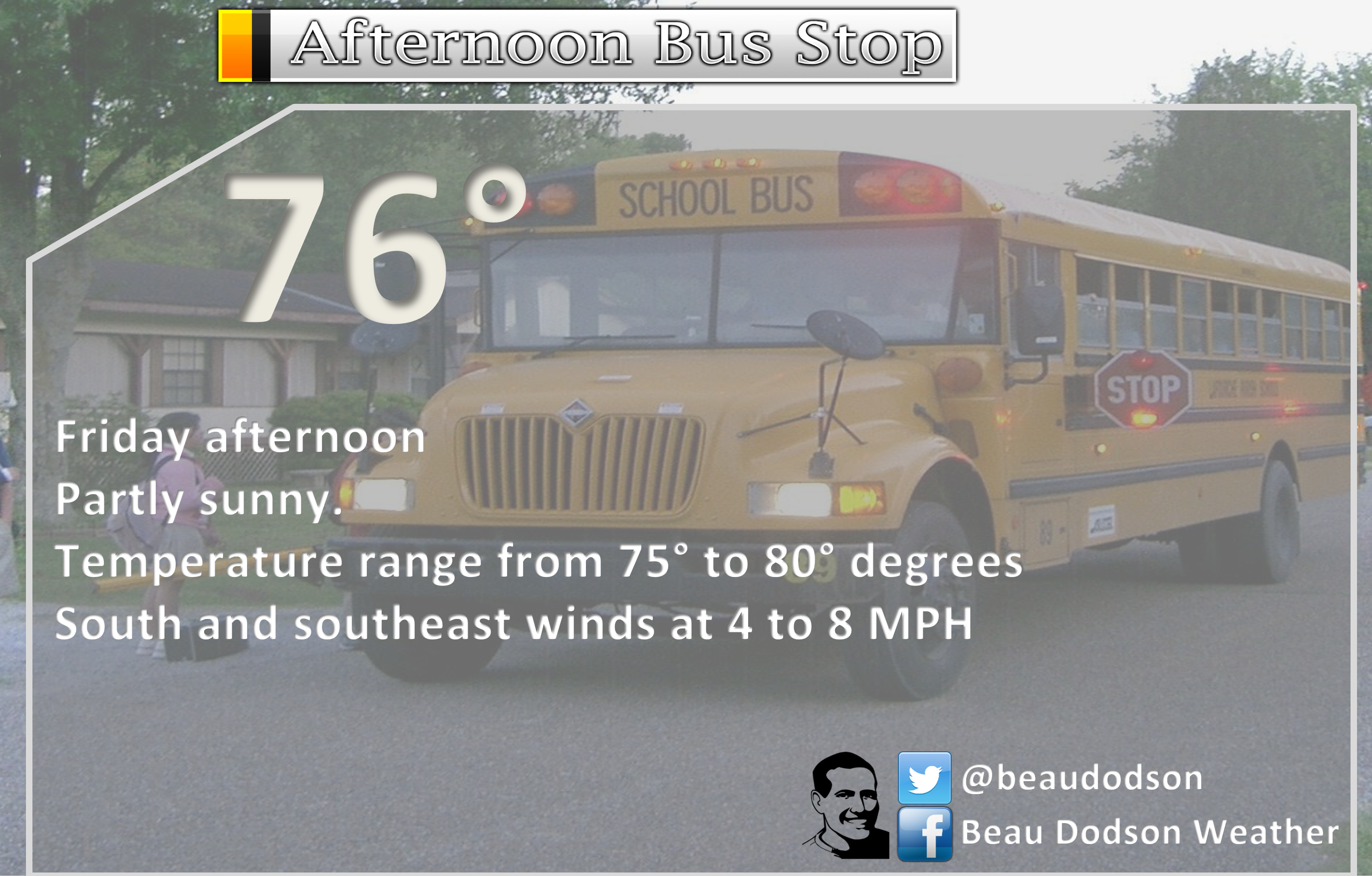
Friday Forecast Details
Forecast: Mostly sunny. Mild.
Temperatures: MO ~ 80 to 84 IL ~ 80 to 84 KY ~ 80 to 84
Winds: Variable winds at 4 to 8 mph. Winds becoming southerly.
What impacts are anticipated from the weather? None.
My confidence in the forecast verifying: High
Is severe weather expected? No
The NWS defines severe weather as 58 mph winds or great, 1″ hail or larger, and/or tornadoes
What is the chance of precipitation? MO ~ 0% IL ~ 0% KY ~ 0%
Coverage of precipitation: None
Should I cancel my outdoor plans? No
.
Friday Night Forecast Details:
Forecast: Mostly clear. Pleasant. Patchy fog possible late.
Temperatures: MO ~ 58 to 62 IL ~ 56 to 60 KY ~ 58 to 62
Winds: Southerly winds from 0 to 5 mph. Light winds.
What impacts are anticipated from the weather? Lower visibility if fog forms.
My confidence in the forecast verifying: High
Is severe weather expected? No
The NWS defines severe weather as 58 mph winds or great, 1″ hail or larger, and/or tornadoes
What is the chance of precipitation? MO ~ 0% IL ~ 0% KY ~ 0%
Coverage of precipitation: None
Should I cancel my outdoor plans? No
.
October 14, 2017
Saturday Forecast Details
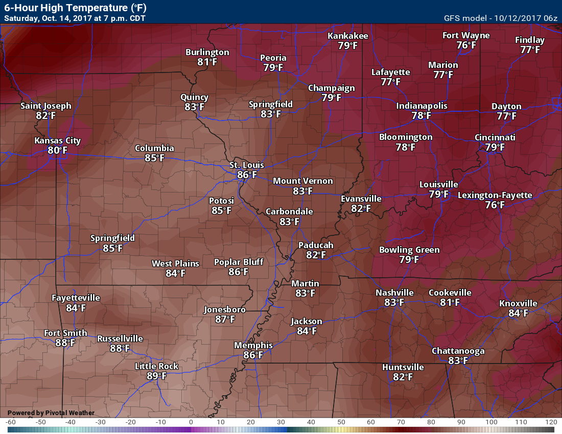
Forecast: Mostly sunny. Very warm for October. Some afternoon clouds possible. Increasing winds during the afternoon.
Temperatures: MO ~ 84 to 86 IL ~ 84 to 86 KY ~ 84 to 86
Winds: Southerly winds at 5 to 10 mph with gusts to 14 mph. Winds may increase late in the day.
What impacts are anticipated from the weather? None.
My confidence in the forecast verifying: High
Is severe weather expected? No
The NWS defines severe weather as 58 mph winds or great, 1″ hail or larger, and/or tornadoes
What is the chance of precipitation? MO ~ 0% IL ~ 0% KY ~ 0%
Coverage of precipitation: None
Should I cancel my outdoor plans? No
.
Saturday Night Forecast Details:
Forecast: Increasing clouds. A band of showers approaching from the north and west. This will be along an incoming cold front. Rain should hold off until after midnight. Rain totals, if any, will be light.
Temperatures: MO ~ 60 to 64 IL ~ 60 to 64 KY ~ 60 to 64
Winds: Southerly winds at 6 to 12 mph. Winds may start to turn more southwest and eventually west late. Winds becoming gusty after 11 pm. Wind gusting above 25 mph possible.
What impacts are anticipated from the weather? Wet roadways after midnight. Small risk for lightning over southeast Missouri and southwest Illinois. Odds favor little or no lightning.
My confidence in the forecast verifying: High
Is severe weather expected? No
The NWS defines severe weather as 58 mph winds or great, 1″ hail or larger, and/or tornadoes
What is the chance of precipitation? MO ~ 40% (late) IL ~ 40% (late) KY ~ 30%
Coverage of precipitation: Scattered. A band of rain should show up on radar to our north and west late Saturday night. It will be moving south and southeast.
Should I cancel my outdoor plans? No
.
October 15, 2017
Sunday Forecast Details
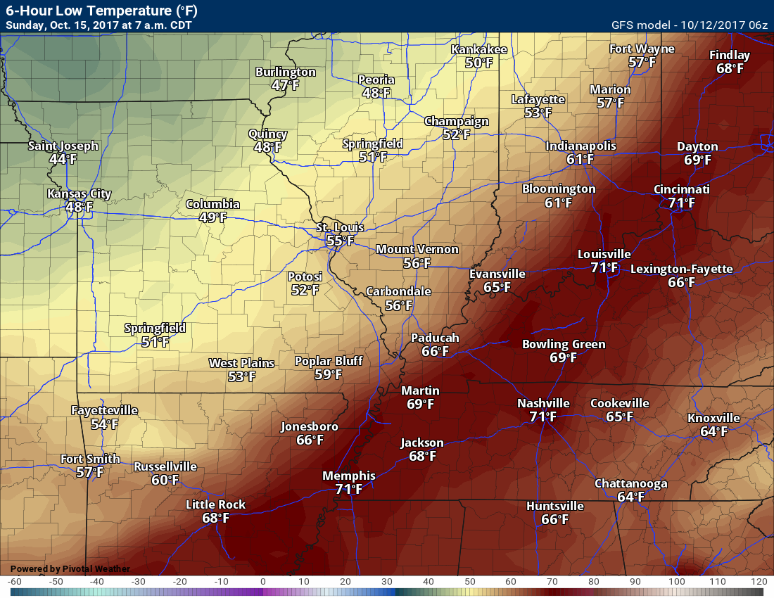
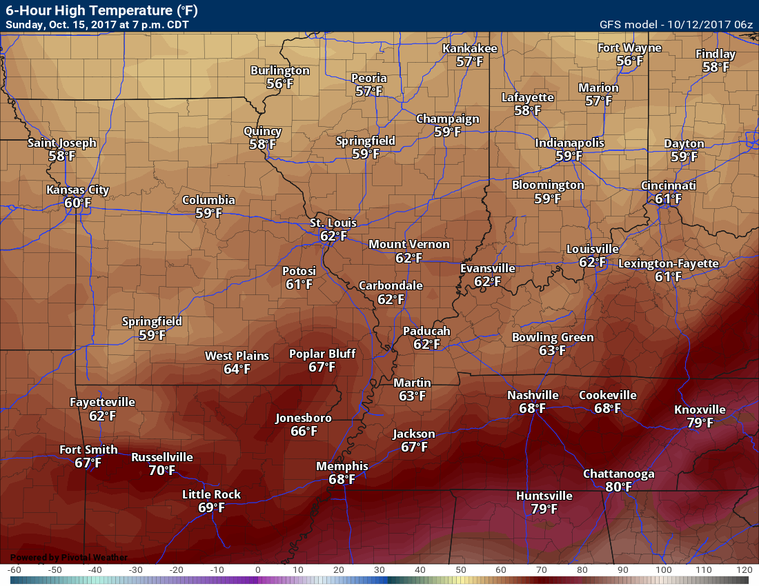
Forecast: Some morning clouds. Clouds will decrease through the day. It will be turning cooler with breezy wind conditions. A chance for morning showers. Showers will likely be spotty. Rain totals from nothing to perhaps 0.25″. Many areas may receive little rainfall.
Temperatures: MO ~ 68 to 72 IL ~ 65 to 70 KY ~ 66 to 74 (temperatures may fall after frontal passage)
Winds: Winds west/northwest becoming north/northwest at 6 to 12 mph with gusts to 25 mph.
What impacts are anticipated from the weather? Early morning potential for wet roadways.
My confidence in the forecast verifying: High
Is severe weather expected? No
The NWS defines severe weather as 58 mph winds or great, 1″ hail or larger, and/or tornadoes
What is the chance of precipitation? MO ~ 30% IL ~ 40% KY ~ 50%
Coverage of precipitation: Scattered along an incoming cold front. A band of rain possible. Rain will exit early in the day.
Should I cancel my outdoor plans? No, but monitor updates and radars.
.
Sunday Night Forecast Details:
Forecast: Clearing sky conditions. Much cooler. Patchy fog possible.
Temperatures: MO ~ 40 to 45 IL ~ 40 to 45 KY ~ 40 to 45
Winds: North and northwest at 4 to 8 mph turning calm late.
What impacts are anticipated from the weather? If fog forms, then lower visibility.
My confidence in the forecast verifying: High
Is severe weather expected? No
The NWS defines severe weather as 58 mph winds or great, 1″ hail or larger, and/or tornadoes
What is the chance of precipitation? MO ~ 0% IL ~ 0% KY ~ 0%
Coverage of precipitation: None
Should I cancel my outdoor plans? No
.
October 16, 2017
Monday Forecast Details
Forecast: Mostly sunny. Cool temperatures. Fallish temperatures.
Temperatures: MO ~ 64 to 68 IL ~ 64 to 68 KY ~ 64 to 68
Winds: North winds at 4 to 8 mph with gusts to 10 mph
What impacts are anticipated from the weather? Lower visibility if fog forms (early in the morning)
My confidence in the forecast verifying: High
Is severe weather expected? No
The NWS defines severe weather as 58 mph winds or great, 1″ hail or larger, and/or tornadoes
What is the chance of precipitation? MO ~ 0% IL ~ 0% KY ~ 0%
Coverage of precipitation: None
Should I cancel my outdoor plans? No
.
Monday Night Forecast Details:
Forecast: Mostly clear. Cool. Patchy fog. It appears that frost is unlikely, but I will monitor the trends for overnight lows. There is a small risk that temperatures might be colder.
Temperatures: MO ~ 38 to 44 IL ~ 38 to 44 KY ~ 40 to 45
Winds: Light winds
What impacts are anticipated from the weather? Lower visibility if fog forms. Small risk of frost.
My confidence in the forecast verifying: Medium.
Is severe weather expected? No
The NWS defines severe weather as 58 mph winds or great, 1″ hail or larger, and/or tornadoes
What is the chance of precipitation? MO ~ 0% IL ~ 0% KY ~ 0%
Coverage of precipitation: None
Should I cancel my outdoor plans? No
.
October 17, 2017
Tuesday Forecast Details
Forecast: Mostly sunny. A little warmer.
Temperatures: MO ~ 70 to 75 IL ~ 70 to 75 KY ~ 70 to 75
Winds: Winds becoming southerly at 0 to 5 mph with gusts to 8 mph
What impacts are anticipated from the weather? None
My confidence in the forecast verifying: High
Is severe weather expected? No
The NWS defines severe weather as 58 mph winds or great, 1″ hail or larger, and/or tornadoes
What is the chance of precipitation? MO ~ 0% IL ~ 0% KY ~ 0%
Coverage of precipitation: None
Should I cancel my outdoor plans? No
.
Tuesday Night Forecast Details:
Forecast: Mostly clear. Not quite as cool. Patchy fog.
Temperatures: MO ~ 44 to 48 IL ~ 44 to 48 KY ~ 44 to 48
Winds: Light winds
What impacts are anticipated from the weather? Lower visibility if fog forms.
My confidence in the forecast verifying: Medium.
Is severe weather expected? No
The NWS defines severe weather as 58 mph winds or great, 1″ hail or larger, and/or tornadoes
What is the chance of precipitation? MO ~ 0% IL ~ 0% KY ~ 0%
Coverage of precipitation: None
Should I cancel my outdoor plans? No
.
Friday afternoon
.

The National Weather Service definition of a severe thunderstorm is one that produces quarter size hail or larger, 58 mph winds or greater, and/or a tornado.
Thursday night through Sunday: Severe weather is not anticipated. I will be monitoring Saturday night into Sunday for a cold front. Perhaps a few storms along the front. Severe weather appears unlikely.
.

Overview
Highlights of the forecast.
- Nice through Saturday
- Another cold front on Sunday/Monday
Short range comments
Subscribers, sign into your WeatherTalk account and see the latest October forecast. Click here for that information.
See the long-range discussion further down in this post.
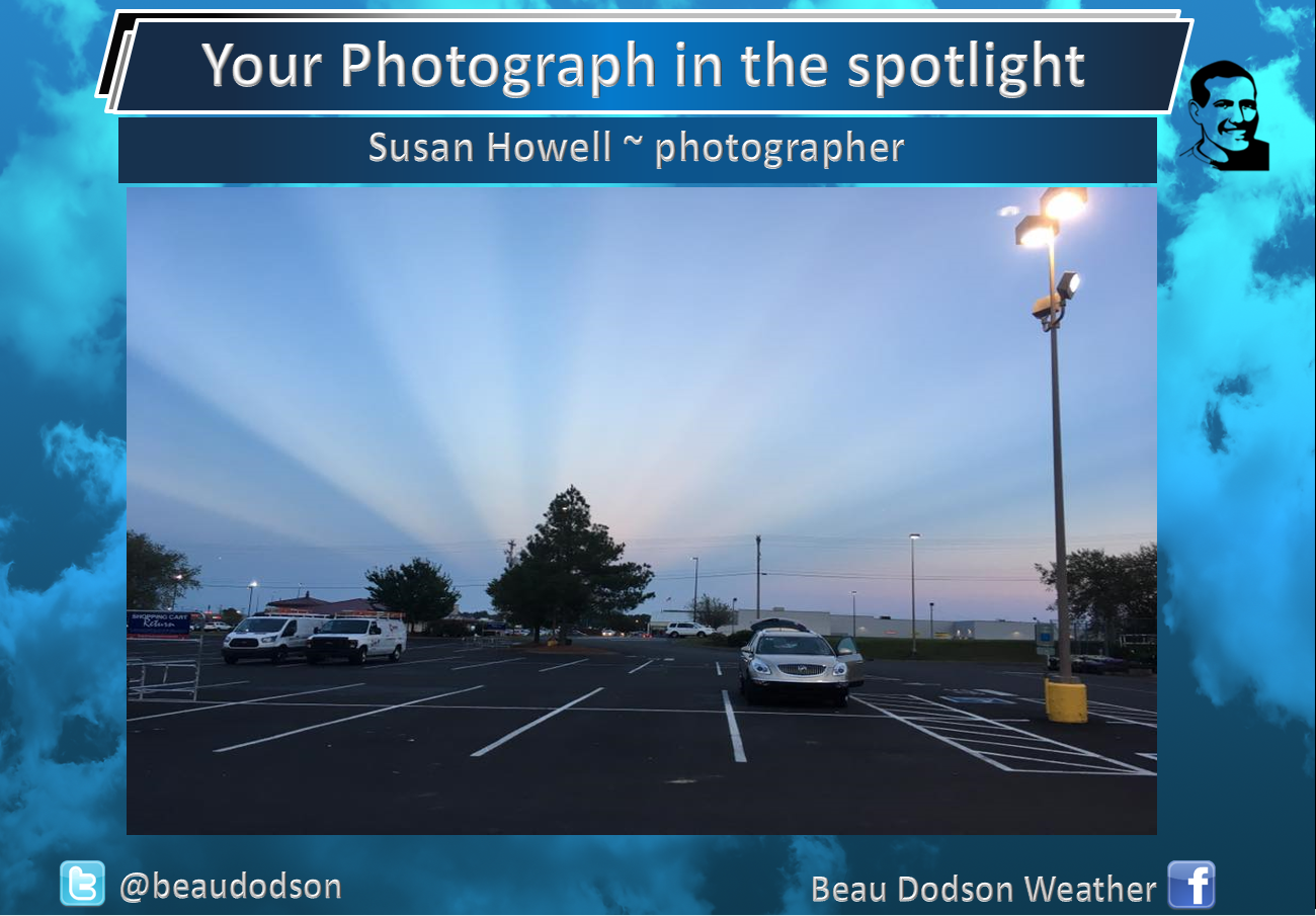
Check out this amazing photograph by Susan Howell.
Here is the explanation behind the photograph.
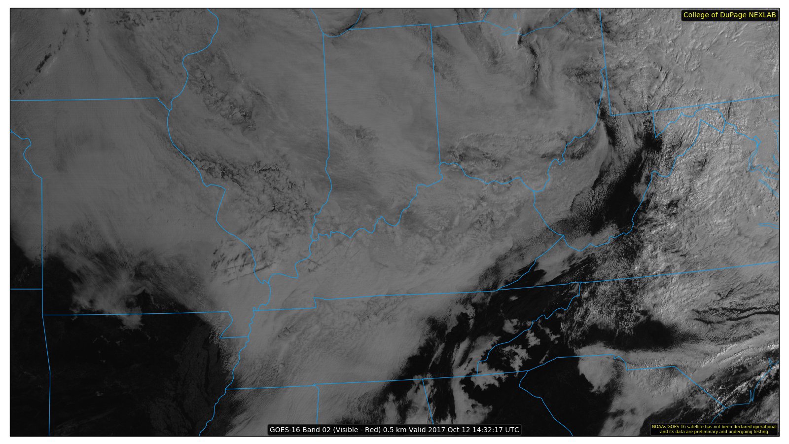
Clouds lingered over our region on Thursday.
Here is the satellite image from Thursday morning. Thick clouds. This was keeping our region cooler than normal.
The clouds were wrapping around an area of low pressure that was centered well to our northwest.
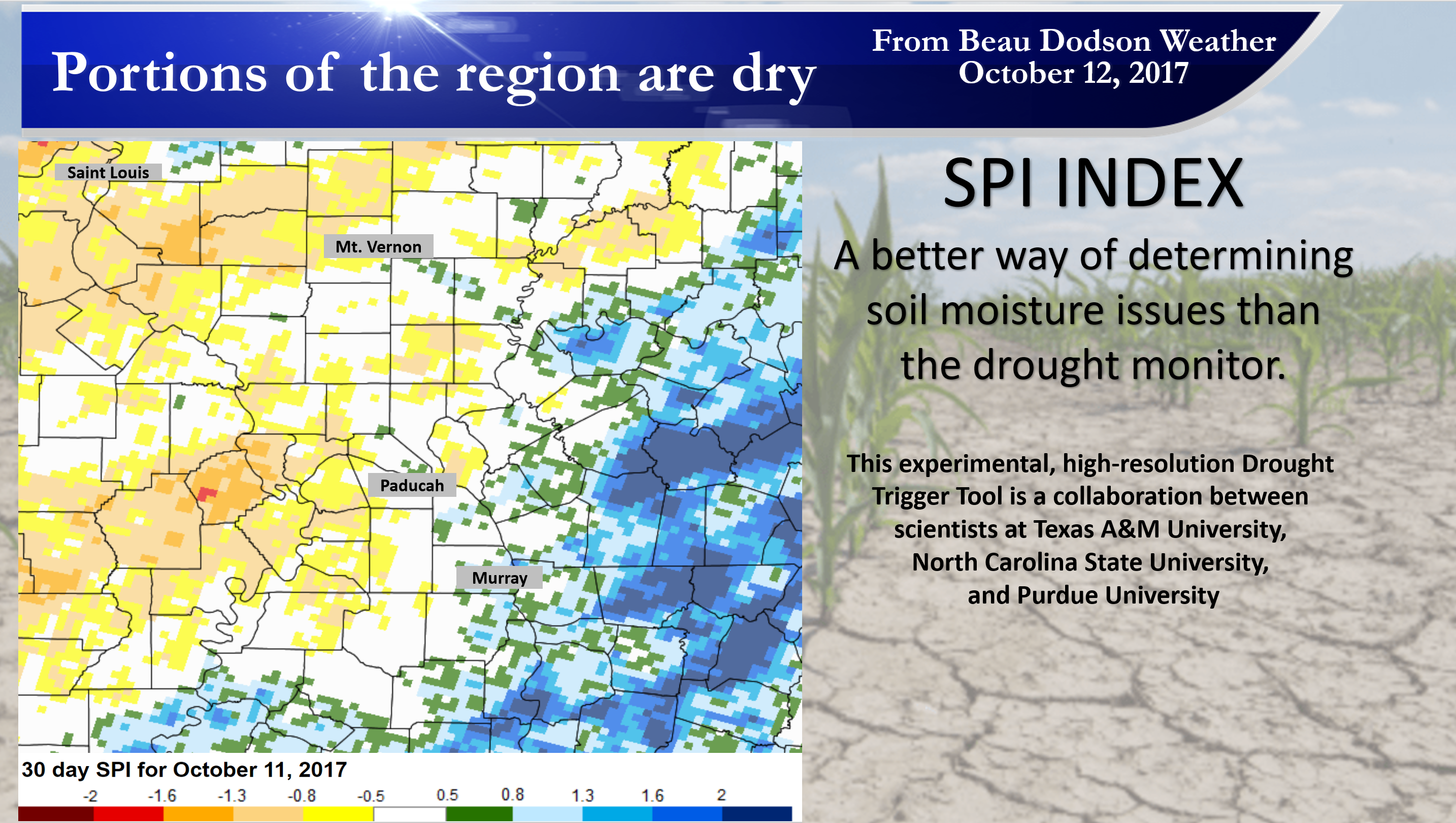
We did pick up some rain over the past two weeks.
Here are some of the latest drought numbers. Some improvement has been noted (at least for some of my forecast counties)
Click images to enlarge
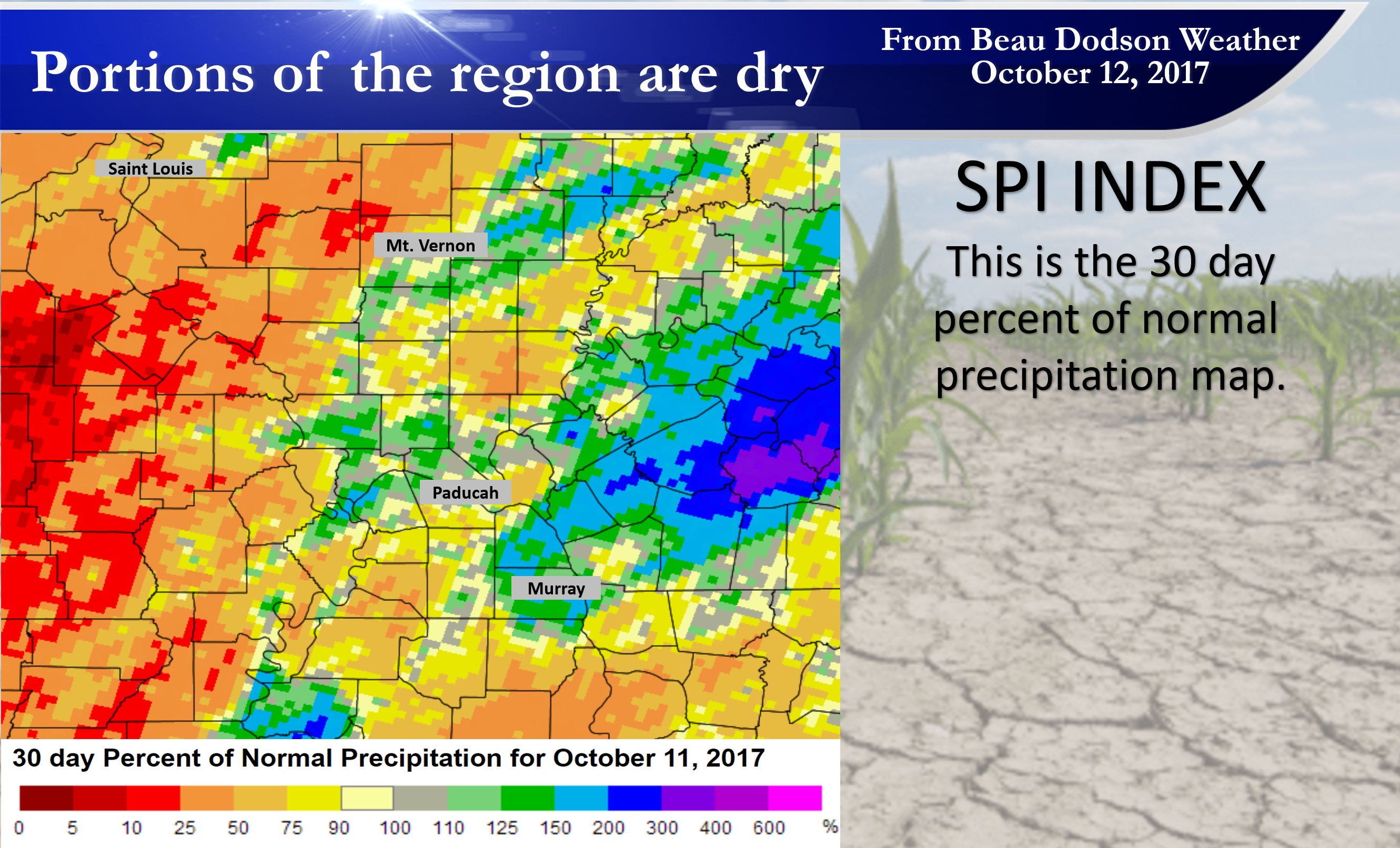
and
This is the 30 day percent of normal precipitation map.
Dry weather will prevail on Friday and Saturday. Temperatures will move back into the upper 70’s to around 80 degrees on Friday. Temperatures will pop into the middle 80’s on Saturday! Above normal, again.
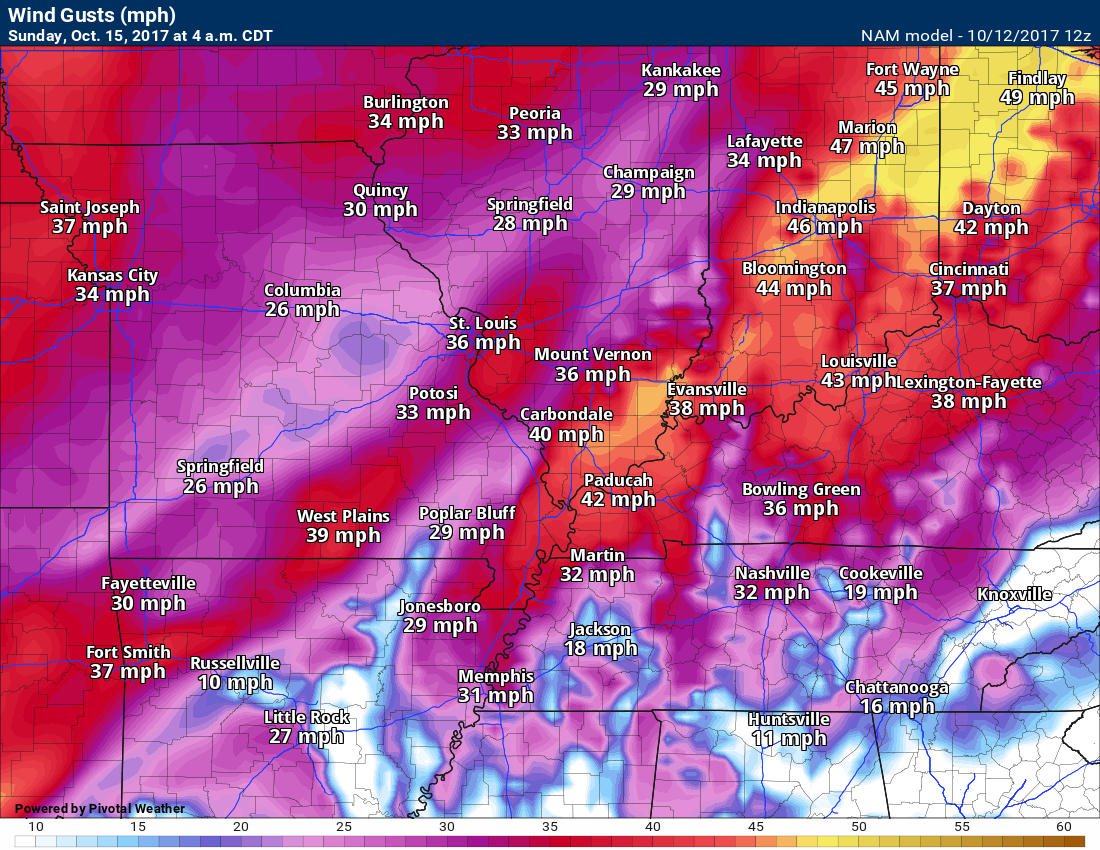
A cold front will approach our region on Saturday night and move through the area on Sunday.
Gusty winds will accompany the front.
Here is the wind gust map for late Saturday night. Some gusts above 20 mph likely.
Models are showing winds gusting into the upper 30’s to around 40 mph. I knocked some off of that, but will monitor trends.
A band of showers and thunderstorms will accompany the front. Severe weather is not anticipated.
Rainfall totals will vary, but perhaps not as much as recent weeks.
Here is the rainfall forecast for this next cold front. Some areas may receive very little measurable rainfall. A few areas may pick up 0.10″ to 0.30″.
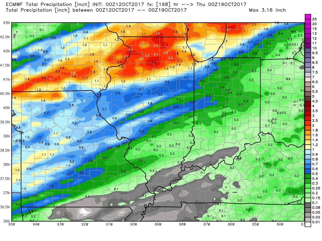
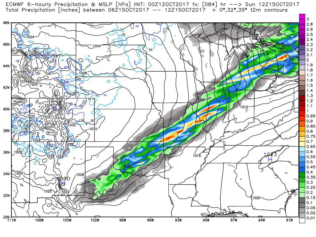
Here is the EC guidance for the cold front. You are looking at six hour rainfall totals.
This first map is for 1 am through 7 am on Sunday. You can see the front approaching from the north and west. The colors represent rain totals. Scale is on the right.
Click images to enlarge
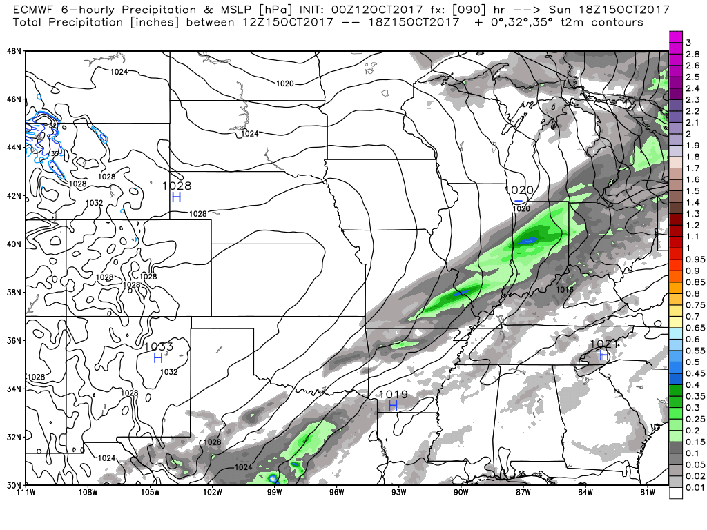
Here is the 7 am to 1 pm Sunday rainfall forecast map.
Notice how the totals are going down. The front will be weakening as it crosses our local region.
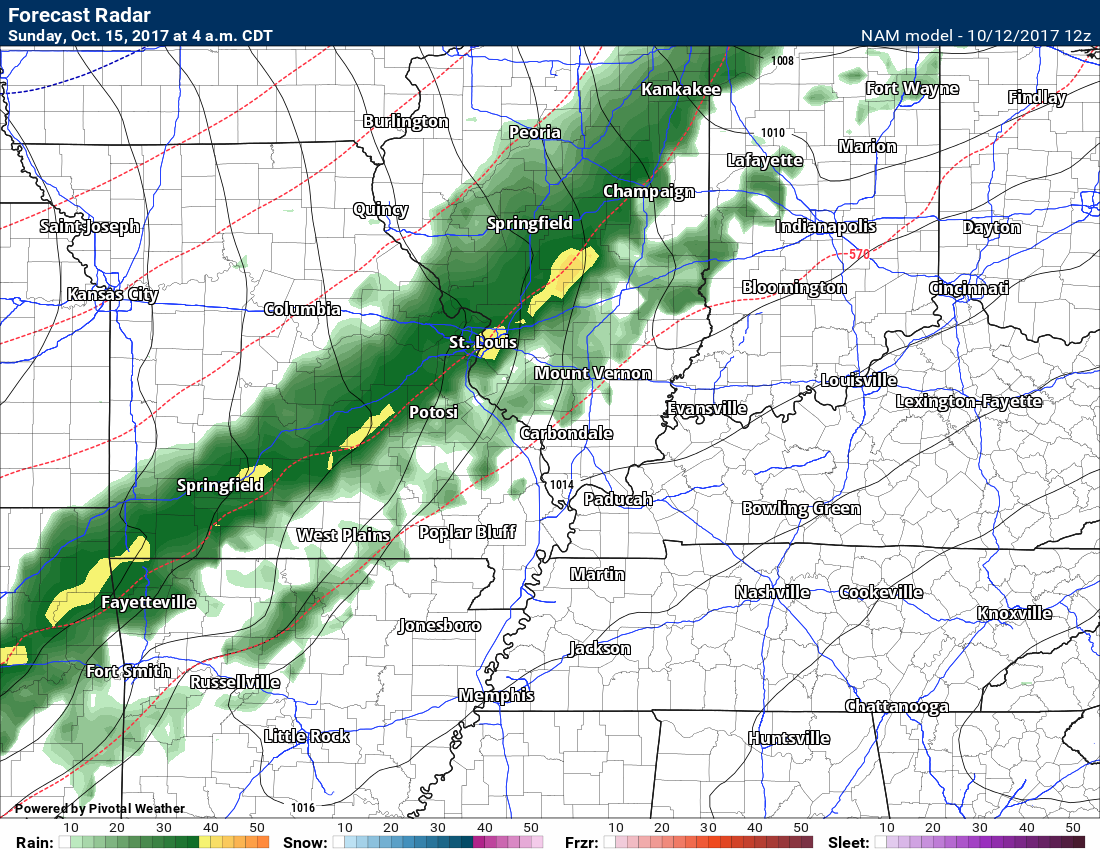
Here is the GFS model guidance. This is the 4 AM future-cast radar map. The GFS also shows a band of showers and perhaps thunderstorms along the front.
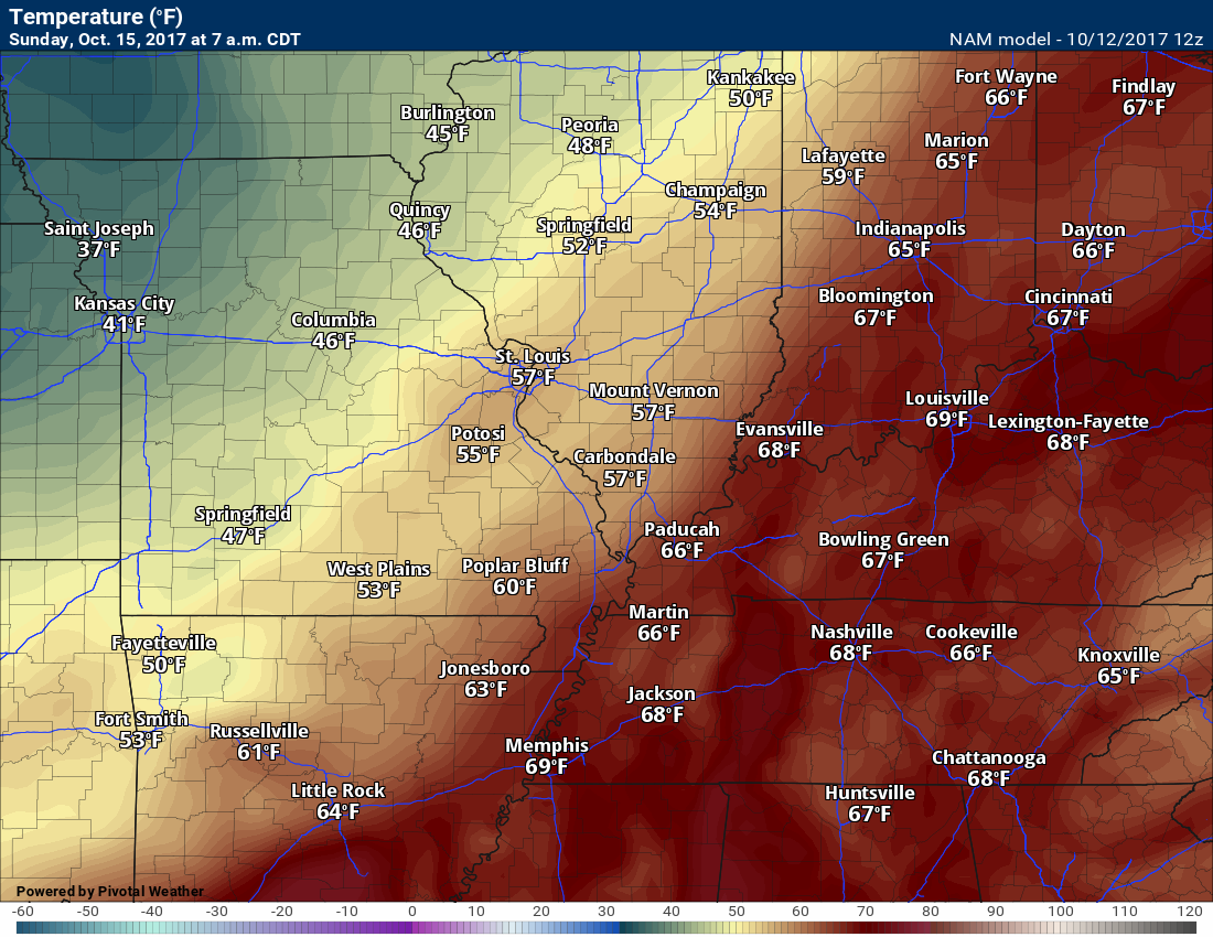
There will be a temperature drop behind the front.
The timing of the front will be the deciding factor in Sunday’s high temperature forecast.
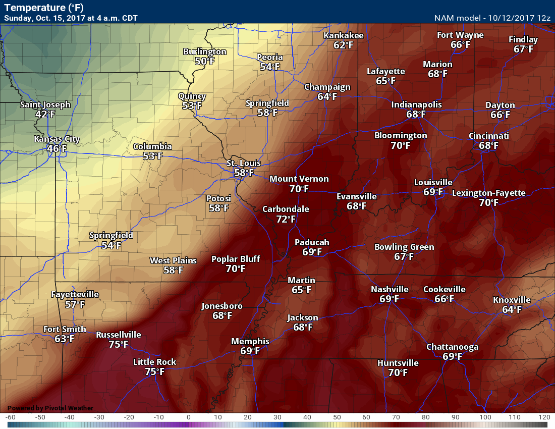
4 AM temperatures (Sunday)
7 AM Sunday temperatures
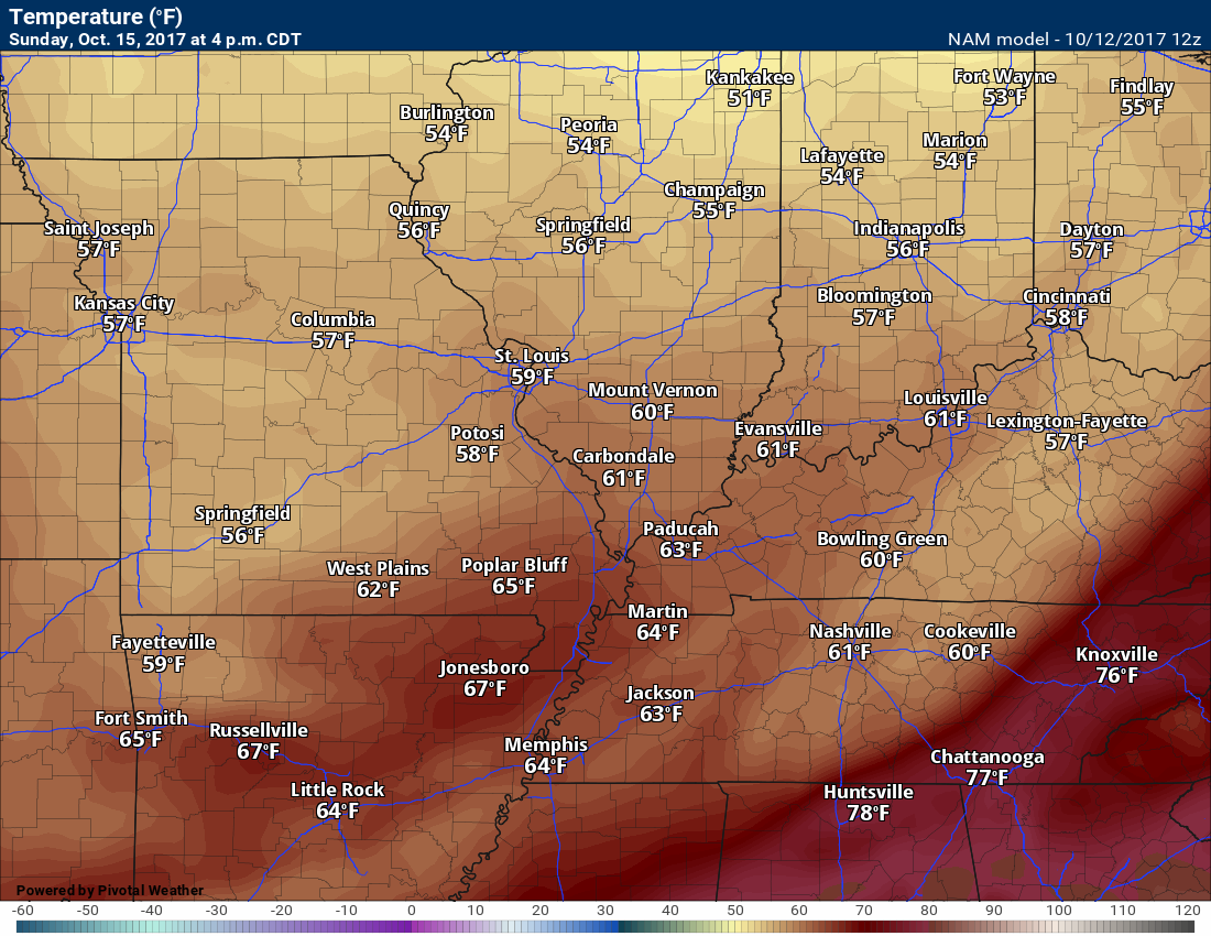
4 PM Sunday temperature forecast
Dry weather for Monday through Wednesday. Cooler, as well.
Here is an animation of the cooler air arriving on Saturday and Sunday. Watch it sweep east/southeast.
Temperature Forecast
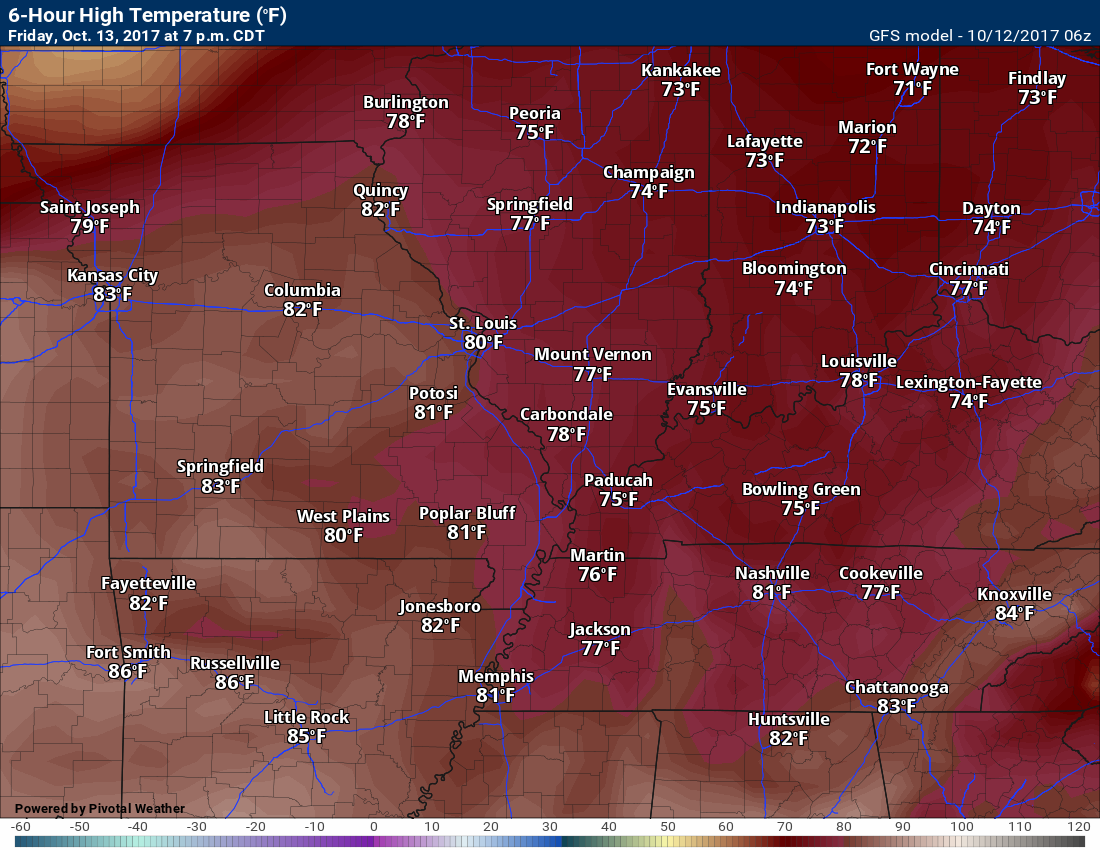
Friday high temperatures
Friday night low temperatures
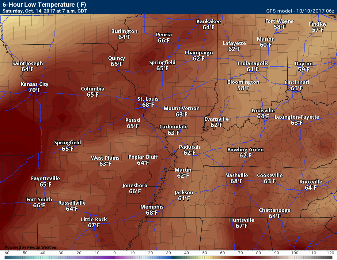
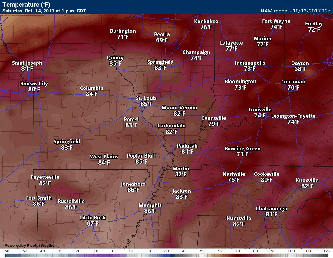
Saturday high temperatures
Saturday night low temperatures
Sunday high temperatures
Temperatures may be warmer on Sunday. This will depend on the speed of the cold front.
If the front holds off until the afternoon then temperatures will be much warmer.
Sunday night low temperatures
Cooler behind the cold front.
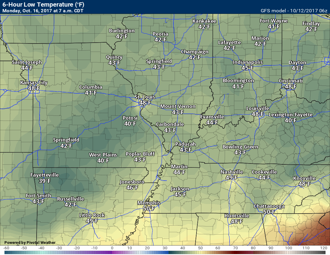
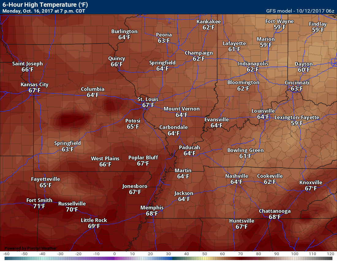
Monday high temperatures
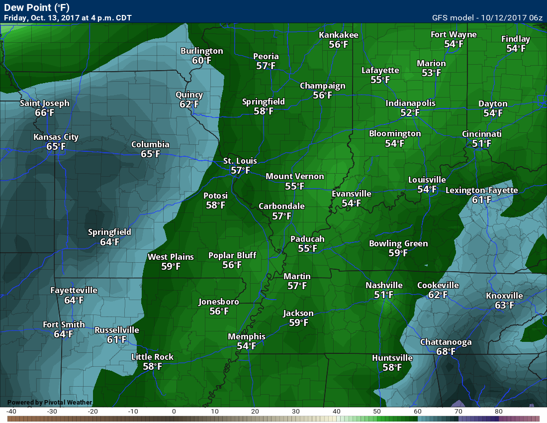
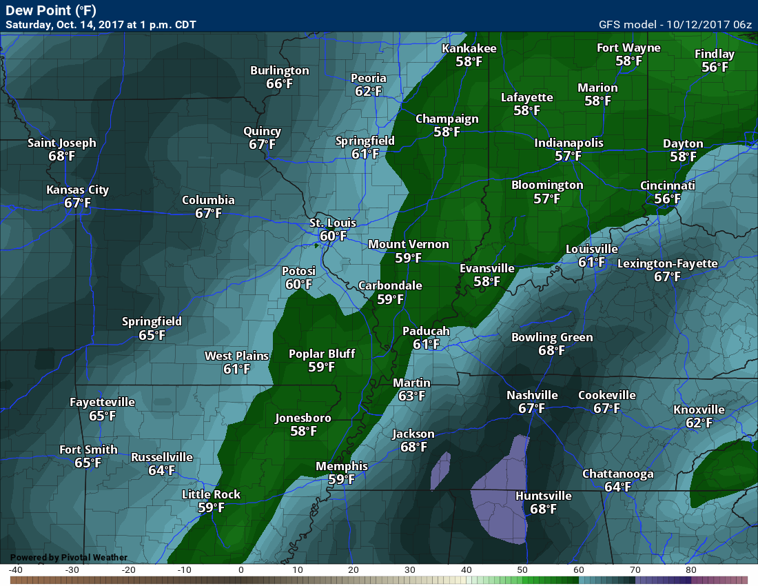
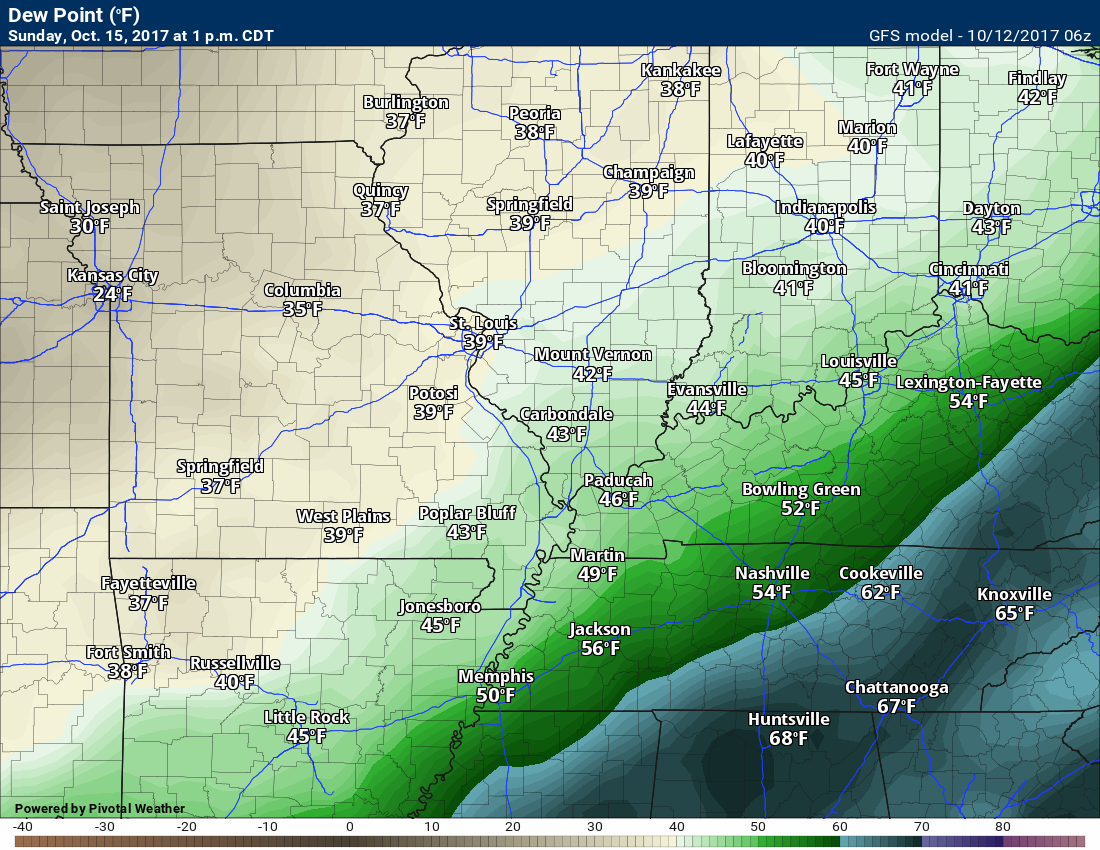
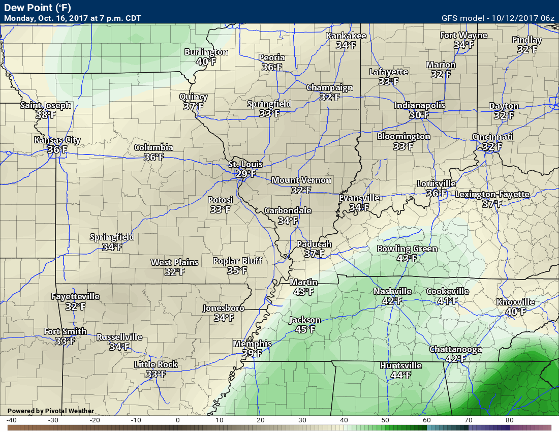
Dewpoint scale
Dew points are what control how you feel outside.

Friday dew points
Saturday dew points
Sunday dew points
Monday dew points
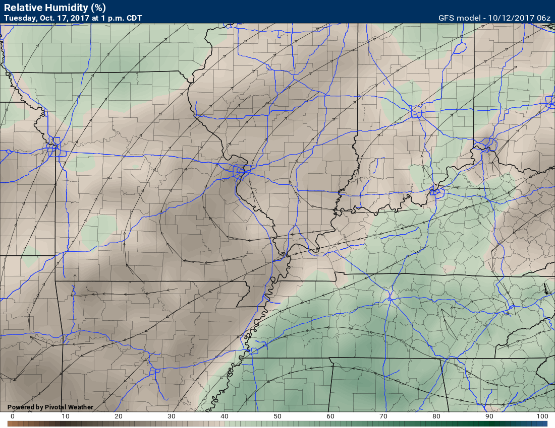
Monday and Tuesday relative humidity levels will dip fairly low.
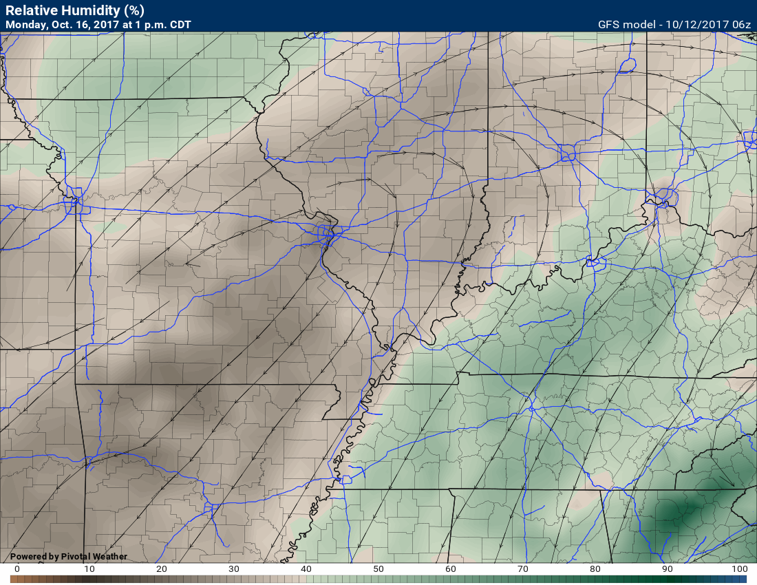
and Tuesday
Long range forecast discussion
The long-range outlook will be centered on cooler air early next week.
Sunday’s cold front will deliver a decent shot of cool “fall” air for our local region.
Low temperatures on Monday, Tuesday, and Wednesday morning will dip into the 40’s. Will we dip into the 30’s?
Some of the guidance is suggesting upper 30’s, but for now, I am forecasting lower 40’s. It would not take much of an adjustment to have upper 30’s across some of our counties. That would most likely occur in southern Illinois and northwest Kentucky.
I will monitor trends.
We may avoid frost with this cool shot.
Monday morning lows
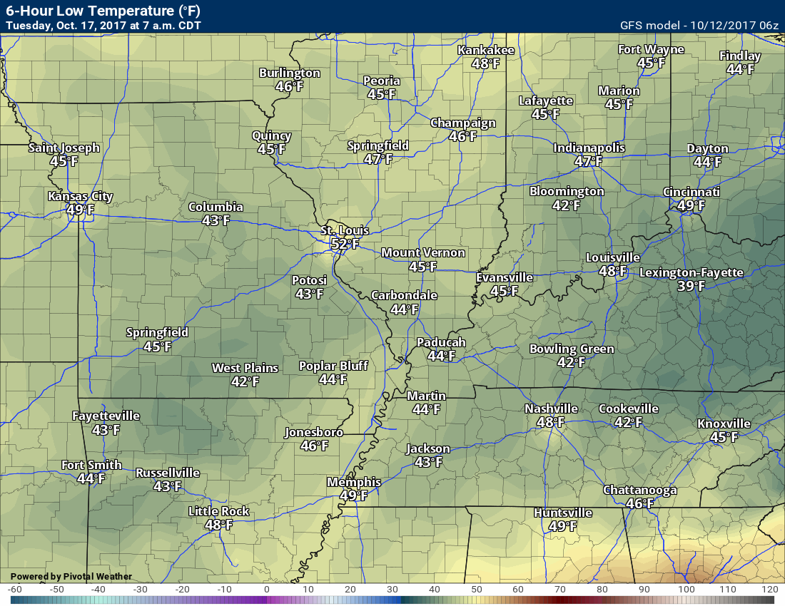
Tuesday morning lows
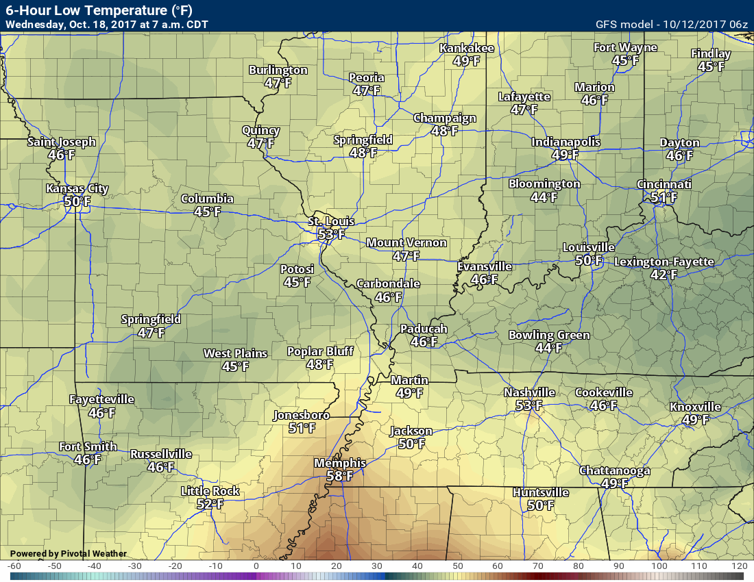
Wednesday morning lows
Dry weather Monday through Wednesday.
.
Are you subscribing to Weather Talk app/text messages and videos? This is what helps support all of the data you see each day.
We now offer premium videos for the short and long-range forecasts! These videos are produced by a team of long-range forecast experts. They are brought to you as bonus information. Activate text option four in order to receive these on your app or via text.
Subscribe at www.beaudodsonweather.com
We offer an Apple and Android app (scroll to the bottom of this page for more information).

Were you aware that I hired a team of meteorologists for long range videos?
To learn more, click this link
http://cms.weathertalk.com/meet-the-team/
.


We offer regional radars and local city radars – if a radar does not update then try another one. Occasional browsers need their cache cleared. You may also try restarting your browser. This will usually fix any problems.
During the winter you can track snow and ice by clicking the winterize button on the local city view interactive radars.
You may email me at beaudodson@usawx.com
Interactive Weather Radar Page. Choose the city nearest your location: Click this link
National interactive radar: Click this link.
The Beau Dodson Weather APP is ready for Apple and Android users. The app provides a faster way for you to receive my text messages. ATT and Verizon are not always reliable when it comes to speed.
Some of you have asked if you can receive the texts on your phone and the app. The answer to that is, yes. The Android app will automatically allow that to happen. On the Apple app, however, you will need to open your app and click the settings button. Make sure the green tab is OFF. Off means you will still receive the texts to your phone and the app. If you have any questions, then email me at beaudodson@usawx.com
The app is for text subscribers.
The direct download, for the Apple app, can be viewed here
https://itunes.apple.com/us/app/id1190136514
Here is the download link for the Android version Click Here
If you have not signed up for the texting service then you may do so at www.beaudodsonweather.com


——————————————————–
Your support helps with the following:

and

.

Whom do you trust for your weather information?
I have studied weather, in our region, since the late 1970’s. I have 40 years of experience in observing our regions weather patterns. My degree is in Broadcast Meteorology and a Bachelor’s of Science.
My resume includes:
Member of the American Meteorological Society.
NOAA Weather-Ready Nation Ambassador.
Meteorologist for McCracken County Emergency Management. I served from 2005 through 2015.
Meteorologist for McCracken County Rescue. 2015 through current
I own and operate the Southern Illinois Weather Observatory.
I am the chief meteorologist for Weather Talk LLC.
I am also a business owner in western Kentucky.
Recipient of the Mark Trail Award, WPSD Six Who Make A Difference Award, Kentucky Colonel, and the Caesar J. Fiamma” Award from the American Red Cross.
In 2005, I helped open the largest American Cross shelter in U.S. history. This was in Houston, Texas. I was deployed to help with the aftermath of Hurricane Katrina and Hurricane Rita. I was a shelter manager of one of the Houston, Texas shelter divisions.
In 2009 I was presented with the Kentucky Office of Highway Safety Award.
Recognized by the Kentucky House of Representatives for my service to the State of Kentucky leading up to several winter storms and severe weather outbreaks.
If you click on the image below you can read the Kentucky House of Representatives Resolution.

I am President of the Shadow Angel Foundation which serves portions of western Kentucky and southern Illinois.
There is a lot of noise on the internet. A lot of weather maps are posted without explanation. You need a trusted source for information.
My forecast philosophy is simple and straight forward.
- Communicate in simple terms
- To be as accurate as possible within a reasonable time frame before an event
- Interact with you on Twitter, Facebook, email, texts, and this blog
- Minimize the “hype” that you might see through other weather sources
- Push you towards utilizing wall-to-wall LOCAL TV coverage during severe weather events

Sign up for my AWARE email by clicking here.
I typically send AWARE emails before severe weather, winter storms, or other active weather situations. I do not email watches or warnings. The emails are a basic “heads up” concerning incoming weather conditions