WeatherTalk monthly operating costs can top $2000.00. Your $5 subscription helps pay for those costs. I work for you.
The $5 will allow you to register up to seven phones!
For $5 a month you can receive the following. You may choose to receive these via your WeatherTalk app or regular text messaging.
Severe weather app/text alerts from my keyboard to your app/cell phone. These are hand typed messages from me to you. During tornado outbreaks, you will receive numerous app/text messages telling you exactly where the tornado is located.
- Daily forecast app/texts from my computer to your app/cell phone.
- Social media links sent directly to your app/cell phone. When I update the blog, videos, or Facebook you will receive the link.
- AWARE emails. These emails keep you well ahead of the storm. They give you several days of lead time before significant weather events.
- Direct access to Beau via text and email. Your very own personal meteorologist. I work for you!
- Missouri and Ohio Valley centered video updates
- Long-range weather videos
- Week one, two, three and four temperature and precipitation outlooks.
Monthly outlooks. - Your subscription also will help support several local charities.
Would you like to subscribe? Subscribe at www.beaudodsonweather.com

I encourage subscribers to use the app vs regular text messaging. We have found text messaging to be delayed during severe weather. The app typically will receive the messages instantly. I recommend people have three to four methods of receiving their severe weather information.
Remember, my app and text alerts are hand typed and not computer generated. You are being given my personal attention during significant weather events.

WWW.WEATHERTALK.COM subscribers, here is my day to day schedule for your weather products.
These are bonus videos and maps for subscribers. I bring these to you from the BAMwx team. I pay them to help with videos.
The Ohio and Missouri Valley videos cover most of our area. They do not have a specific Tennessee Valley forecast but may add one in the future.
The long-range video is technical. Over time, you can learn a lot about meteorology from the long range video. Just keep in mind, it is a bit more technical.


.
![]()

.

October 10, 2018
Wednesday forecast: Cloudy with periodic showers and thunderstorms likely.
Temperatures: MO ~ 74 to 82 IL ~ 76 to 82 KY ~ 76 to 82 TN ~ 76 to 82
What is the chance of precipitation? MO ~ 60% IL ~ 70% KY ~ 80% TN ~ 80%
Coverage of precipitation: Numerous
Wind: South and southwest at 8 to 16 mph
What impacts are anticipated from the weather? Wet roadways. Lightning.
My confidence in the forecast verifying: Medium
Is severe weather expected? The risk of severe weather is low.
The NWS defines severe weather as 58 mph wind or great, 1″ hail or larger, and/or tornadoes
Should I cancel my outdoor plans? Have a plan B
UV Index: 1 to 2 low
Sunrise: 6:59 AM
Wednesday Night Forecast Details:
Forecast: Cloudy early with any remaining showers ending from west to east. The showers may linger a bit longer over the Pennyrile area of western Kentucky. Turning cooler. Clearing overnight.
Temperatures: MO ~ 45 to 50 IL ~ 45 to 50 KY ~ 46 to 50 TN ~ 48 to 52
What is the chance of precipitation? MO ~ 10% IL ~ 30% early KY ~ 40% early TN ~ 40% early
Coverage of precipitation: Precipitation ending
Wind: Becoming west/northwest and eventually north/northwest at 8 to 16 mph
What impacts are anticipated from the weather? Evening wet roadways
My confidence in the forecast verifying: High
Is severe weather expected? No
The NWS defines severe weather as 58 mph wind or great, 1″ hail or larger, and/or tornadoes
Should I cancel my outdoor plans? Have a plan B (esp early)
Sunset: 6:25 PM
Moonrise: 8:25 AM New Moon
Moonset: 7:46 PM
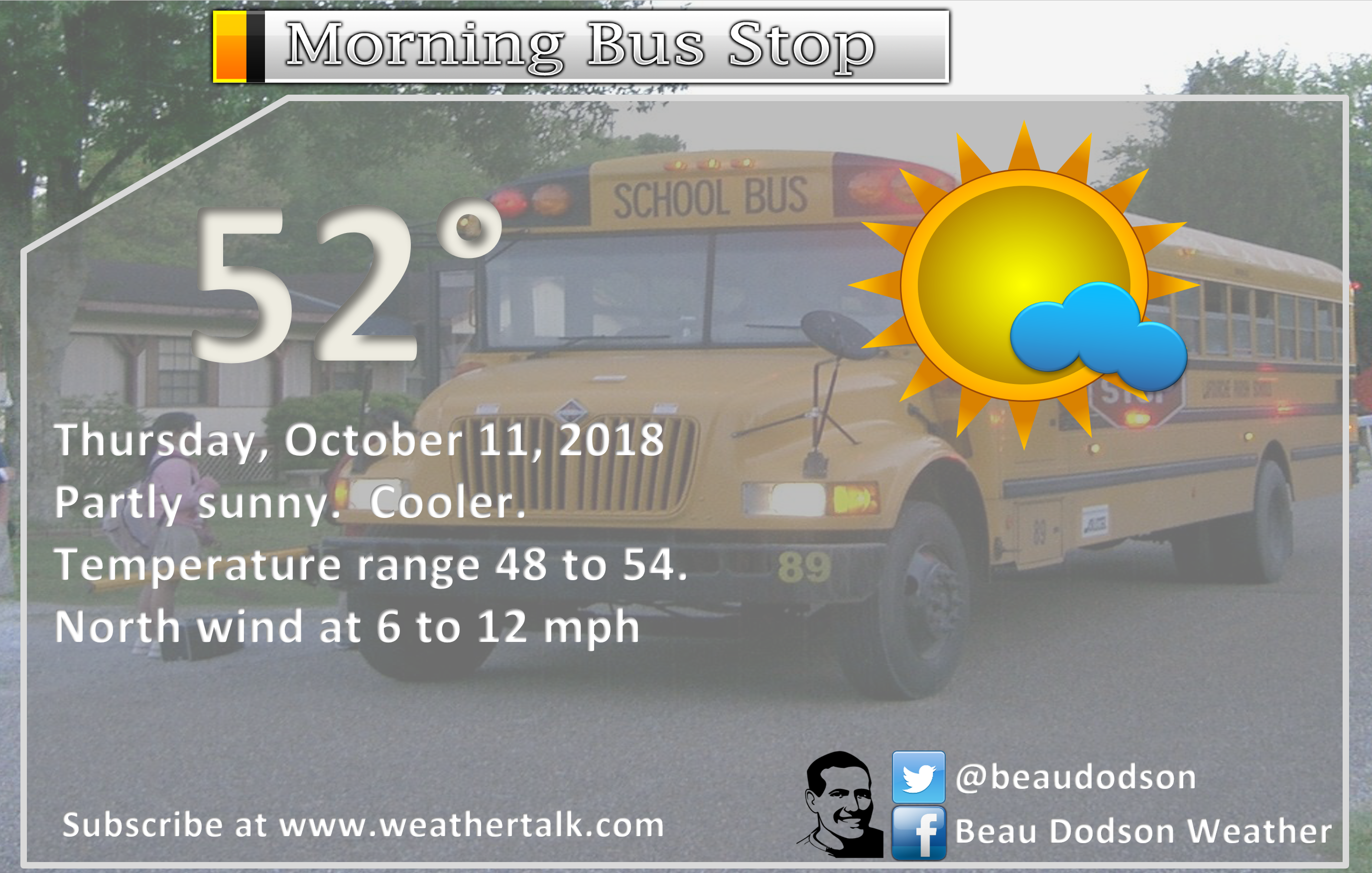
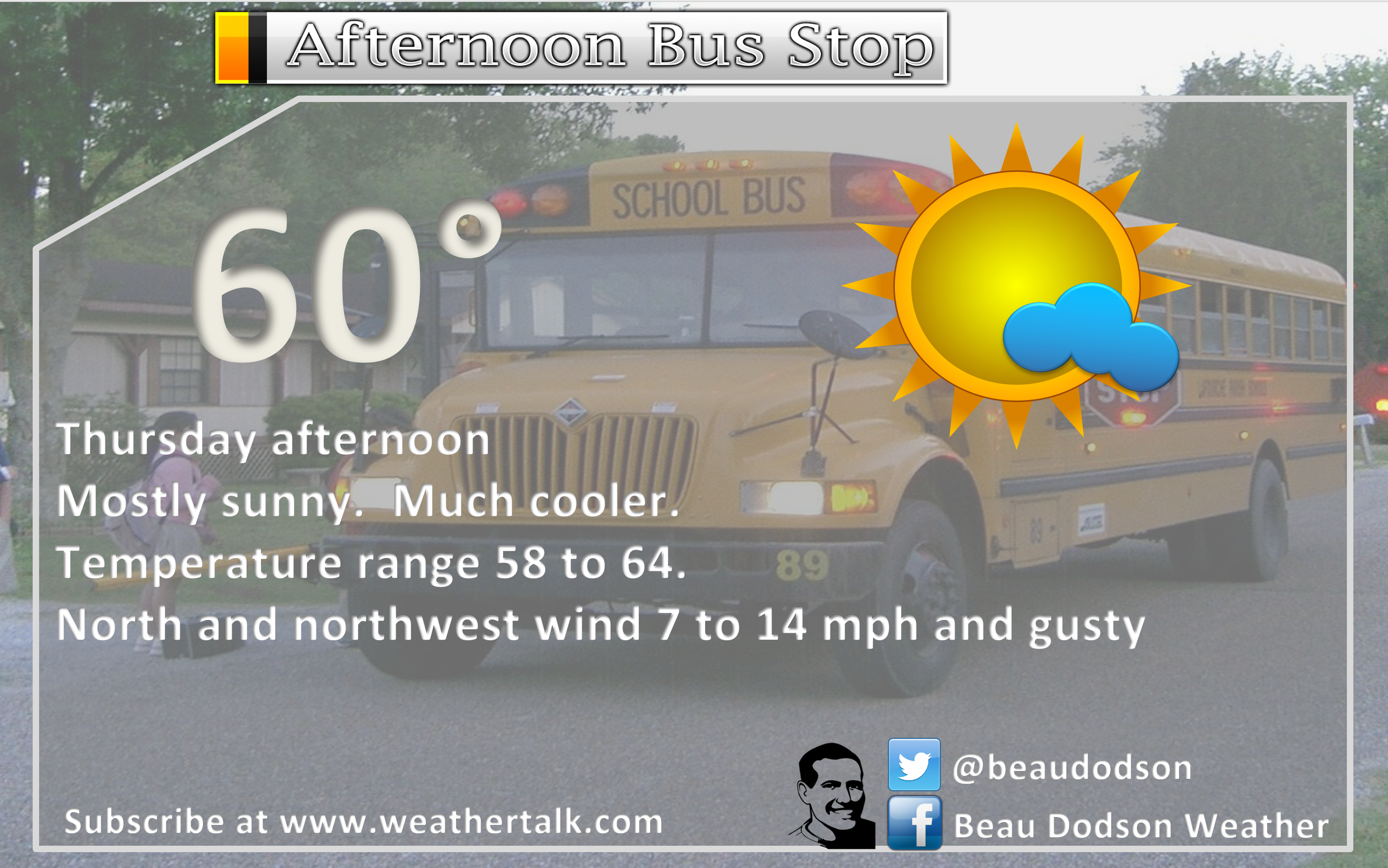
October 11, 2018
Thursday forecast: Partly to mostly sunny. Much cooler temperatures.
Temperatures: MO ~ 58 to 64 IL ~ 58 to 64 KY ~ 58 to 64 TN ~ 58 to 64
What is the chance of precipitation? MO ~ 0% IL ~ 0% KY ~ 10% TN ~ 10%
Coverage of precipitation: Most likely none. Rain should have ended.
Wind: North and northwest at 10 to 20 mph. Gusty.
What impacts are anticipated from the weather? None
My confidence in the forecast verifying: High
Is severe weather expected? No
The NWS defines severe weather as 58 mph wind or great, 1″ hail or larger, and/or tornadoes
Should I cancel my outdoor plans? No
UV Index: 5 Medium
Sunrise: 7:00 AM
Thursday Night Forecast Details:
Forecast: Mostly clear. Patchy fog possible. Chilly temperatures. Winds should be too strong for frost.
Temperatures: MO ~ 38 to 44 IL ~ 38 to 44 KY ~ 40 to 44 TN ~ 42 to 46
What is the chance of precipitation? MO ~ 0% IL ~ 0% KY ~ 0% TN ~ 0%
Coverage of precipitation: None
Frost Risk: Wind may prevent frost from forming. Low risk. Monitor updates.
Wind: North at 6 to 12 mph
What impacts are anticipated from the weather? Lower visibility if fog forms.
My confidence in the forecast verifying: High
Is severe weather expected? No
The NWS defines severe weather as 58 mph wind or great, 1″ hail or larger, and/or tornadoes
Should I cancel my outdoor plans? No
Sunset: 6:24 PM
Moonrise: 9:29 AM Waxing Crescent
Moonset: 8:23 PM
October 12, 2018
Friday forecast: Mostly sunny during the morning. Increasing clouds through the day. Light rain developing from west to east during mainly the afternoon hours.
Temperatures: MO ~ 50 to 55 IL ~ 53 to 56 KY ~ 55 to 60 TN ~ 55 to 60
What is the chance of precipitation? MO ~ 50% to 60% IL ~ 50% to 60% KY ~ 40% to 50% TN ~ 40% to 50%
Coverage of precipitation: None early and then increasing coverage during the afternoon and evening hours. Light rain.
Wind: North and northwest at 6 to 12 mph
What impacts are anticipated from the weather? None during the morning. Wet roadways during the afternoon and evening hours.
My confidence in the forecast verifying: High
Is severe weather expected? No
The NWS defines severe weather as 58 mph wind or great, 1″ hail or larger, and/or tornadoes
Should I cancel my outdoor plans? Not during the morning. Afternoon hours will likely see rain appearing on radar and moving west to east through the area.
UV Index: 3 to 5 moderate
Sunrise: 7:00 AM
Friday Night Forecast Details:
Forecast: Mostly cloudy early. Light showers possible before 12 AM. Chilly. Clearing late.
Temperatures: MO ~ 38 to 44 IL ~ 38 to 44 KY ~ 40 to 44 TN ~ 40 to 44
What is the chance of precipitation? MO ~ 30% ending IL ~ 30% ending KY ~ 40% first half of the night TN ~ 40% first half of the night
Coverage of precipitation: Patchy light rain possible.
Frost Risk: Most likely no frost, but monitor updates.
Wind: North and northeast at 5 to 10 mph
What impacts are anticipated from the weather? A few wet roadways before midnight.
My confidence in the forecast verifying: Medium
Is severe weather expected? No
The NWS defines severe weather as 58 mph wind or great, 1″ hail or larger, and/or tornadoes
Should I cancel my outdoor plans? Have a plan B and monitor radars. Some light rain is possible in the region.
Sunset: 6:12 PM
Moonrise: 10:31 AM Waxing Crescent
Moonset: 9:02 PM
October 13, 2018
Saturday forecast: Cool. Some morning clouds. Becoming sunny. Late in the afternoon, a few more clouds may spread into the region from the southwest.
Temperatures: MO ~ 54 to 58 IL ~ 54 to 58 KY ~ 54 to 58 TN ~ 54 to 58
What is the chance of precipitation? MO ~ 10% IL ~ 0% KY ~ 0% TN ~ 0%
Coverage of precipitation: Most likely none
Wind: Northeast wind becoming east and southeast at 5 to 10 mph
What impacts are anticipated from the weather? Most likely none
My confidence in the forecast verifying: High
Is severe weather expected? No
The NWS defines severe weather as 58 mph wind or great, 1″ hail or larger, and/or tornadoes
Should I cancel my outdoor plans? No
UV Index: 5 moderate
Sunrise: 7:01 AM
Saturday Night Forecast Details:
Forecast: Increasing cloud cover. Rain developing from southwest to northeast. Most of the rain will occur late in the night. The first part of the night should remain dry, but monitor updates in case the rain arrives earlier than anticipated.
Temperatures: MO ~ 44 to 48 IL ~ 44 to 48 KY ~ 44 to 48 TN ~ 44 to 48
What is the chance of precipitation? MO ~ 60% IL ~ 60% KY ~ 60% TN ~ 60%
Coverage of precipitation: Increasing rain coverage through the night.
Frost Risk: None
Wind: East and southeast at 4 to 8 mph
What impacts are anticipated from the weather? Wet roadways.
My confidence in the forecast verifying: Medium
Is severe weather expected? No
The NWS defines severe weather as 58 mph wind or great, 1″ hail or larger, and/or tornadoes
Should I cancel my outdoor plans? Have a plan B and monitor updates. Rain should spread from southwest to northeast. It is possible the rain holds off until later in the night. Rain will arrive first along the Missouri and Arkansas border.
Sunset: 6:21 PM
Moonrise: 11:30 AM Waxing Crescent
Moonset: 9:44 PM
October 14, 2018
Sunday forecast: Mostly cloudy. Rain likely.
Temperatures: MO ~ 54 to 58 IL ~ 54 to 58 KY ~ 54 to 58 TN ~ 56 to 62
What is the chance of precipitation? MO ~ 70% IL ~ 70% KY ~ 70% TN ~ 70%
Coverage of precipitation: Becoming widespread
Wind: East winds at 6 to 12 mph
What impacts are anticipated from the weather? Wet roadways. Lightning possible.
My confidence in the forecast verifying: Medium
Is severe weather expected? No
The NWS defines severe weather as 58 mph wind or great, 1″ hail or larger, and/or tornadoes
Should I cancel my outdoor plans? Have a plan B
UV Index: 1 to 3 Low
Sunrise: 7:02 AM
Sunday Night Forecast Details:
Forecast: Mostly cloudy. Rain likely.
Temperatures: MO ~ 42 to 44 IL ~ 44 to 46 KY ~ 44 to 48 TN ~ 44 to 48
What is the chance of precipitation? MO ~ 40% to 50% early IL ~ 60% KY ~ 70% TN ~ 70%
Coverage of precipitation: Scattered to numerous
Frost Risk: None
Wind: North at 7 to 14 mph and gusty
What impacts are anticipated from the weather? Wet roadways. Low risk of lightning.
My confidence in the forecast verifying Medium
Is severe weather expected? No
The NWS defines severe weather as 58 mph wind or great, 1″ hail or larger, and/or tornadoes
Should I cancel my outdoor plans? Have a plan B
Sunset: 6:19 PM
Moonrise: 12:26 PM Waxing Crescent
Moonset: 10:29 PM
October 15, 2018
Monday forecast: Quite a few clouds. A chance of rain showers. Chilly temperatures.
Temperatures: MO ~ 48 to 54 IL ~ 48 to 54 KY ~ 50 to 54 TN ~ 50 to 54
What is the chance of precipitation? MO ~ 30% IL ~ 30% KY ~ 30% TN ~ 30%
Coverage of precipitation: Perhaps widespread
Wind: North and northwest at 7 to 14 mph and gusty
What impacts are anticipated from the weather? Wet roadways.
My confidence in the forecast verifying: Medium
Is severe weather expected? No
The NWS defines severe weather as 58 mph wind or great, 1″ hail or larger, and/or tornadoes
Should I cancel my outdoor plans? Have a plan B and monitor updates.
UV Index: 1 to 3 Low
Sunrise: 7:03 AM
Monday Night Forecast Details:
Forecast: Disagreement in data about Monday nights forecast. Guidance shows another potential rainmaker. I will be monitoring this. Clearing and chilly. Patchy fog possible. Frost possible if the wind dies down and if we don’t have clouds and rain. Clouds and rain would prevent frost.
Temperatures: MO ~ 34 to 38 IL ~ 34 to 38 KY ~ 36 to 40 TN ~ 38 to 44
What is the chance of precipitation? Monitor updates
Coverage of precipitation: Monitor updates
Frost Risk: Frost possible Monday and Tuesday night. Monitor updates.
Wind: Northwest at 5 to 10 mph becoming variable at 3 to 6
What impacts are anticipated from the weather? Perhaps wet roadways. Low confidence in rain chances. Lower visibility in fog. Monitor the risk of frost. Those with sensitive outdoor plants will want to monitor the frost risk.
My confidence in the forecast verifying: LOW
Is severe weather expected? No
The NWS defines severe weather as 58 mph wind or great, 1″ hail or larger, and/or tornadoes
Should I cancel my outdoor plans? Monitor updates
Sunset: 6:18 PM
Moonrise: 1:17 PM Waxing Crescent
Moonset: 11:18 PM
October 16, 2018
Tuesday forecast: Partly sunny. Cool.
Temperatures: MO ~ 52 to 56 IL ~ 52 to 56 KY ~ 54 to 58 TN ~ 54 to 58
What is the chance of precipitation? MO ~ 30% IL ~ 30% KY ~ 30% TN ~ 30%
Coverage of precipitation: None
Wind: North 6 to 12 mph
What impacts are anticipated from the weather? None
My confidence in the forecast verifying: Medium
Is severe weather expected? No
The NWS defines severe weather as 58 mph wind or great, 1″ hail or larger, and/or tornadoes
Should I cancel my outdoor plans? No
UV Index: 5 Moderate
Sunrise: 7:04 AM
Tuesday Night Forecast Details:
Forecast: Mostly clear. Chilly. I will be monitoring the risk of frost.
Temperatures: MO ~ 36 to 42 IL ~ 36 to 42 KY ~ 36 to 42 TN ~ 38 to 44
What is the chance of precipitation? MO ~ 0% IL ~ 0% KY ~ 0% TN ~ 0%
Coverage of precipitation: None
Frost Risk: Low (for now)
Wind: West at 4 to 8 mph
What impacts are anticipated from the weather? Monitor the risk of frost. Those with sensitive outdoor plants will want to monitor the frost risk.
My confidence in the forecast verifying:
Is severe weather expected?
The NWS defines severe weather as 58 mph wind or great, 1″ hail or larger, and/or tornadoes
Should I cancel my outdoor plans?
Sunset: 6:17 PM
Moonrise: 2:04 PM Waxing Crescent
Moonset: 12:01 AM
October 17, 2018
Wednesday forecast: Mostly sunny.
Temperatures: MO ~ 60 to 64 IL ~ 60 to 64 KY ~ 60 to 64 TN ~ 60 to 64
What is the chance of precipitation? MO ~ 0% IL ~ 0% KY ~ 0% TN ~ 0%
Coverage of precipitation: None
Wind: North and northeast at 5 to 10 mph
What impacts are anticipated from the weather? None
My confidence in the forecast verifying: Medium
Is severe weather expected? No
The NWS defines severe weather as 58 mph wind or great, 1″ hail or larger, and/or tornadoes
Should I cancel my outdoor plans? No
UV Index: 5 Moderate
Sunrise: 7:05 AM
Wednesday Night Forecast Details:
Forecast: Mostly clear. Cool. Frost possible.
Temperatures: MO ~ 34 to 38 IL ~ 34 to 38 KY ~ 36 to 40 TN ~ 38 to 44
What is the chance of precipitation? MO ~ 0% IL ~ 0% KY ~ 0% TN ~ 0%
Coverage of precipitation: None
Frost Risk: Medium
Wind: Light and variable
What impacts are anticipated from the weather? Perhaps frost. Monitor updates if you have outdoor plants that are of concern.
My confidence in the forecast verifying: Medium
Is severe weather expected? No
The NWS defines severe weather as 58 mph wind or great, 1″ hail or larger, and/or tornadoes
Should I cancel my outdoor plans? No
Sunset: 6:15 PM
Moonrise: 2:46 PM First Quarter
Moonset: 12:10 AM
October 18, 2018
Thursday forecast: Mosty sunny. Mild.
Temperatures: MO ~ 60 to 65 IL ~ 60 to 65 KY ~ 60 to 65 TN ~ 60 to 65
What is the chance of precipitation? MO ~ 0% IL ~ 0% KY ~ 0% TN ~ 0%
Coverage of precipitation: None
Wind: Northeast wind 5 to 10 mph
What impacts are anticipated from the weather? None
My confidence in the forecast verifying: Medium
Is severe weather expected? No
The NWS defines severe weather as 58 mph wind or great, 1″ hail or larger, and/or tornadoes
Should I cancel my outdoor plans? No
UV Index: 5 Moderate
Sunrise: 7:06 AM
Thursday Night Forecast Details:
Forecast: Mostly clear and cool.
Temperatures: MO ~ 40 to 44 IL ~ 40 to 44 KY ~ 40 to 44 TN ~ 40 to 44
What is the chance of precipitation? MO ~ 0% IL ~ 0% KY ~ 0% TN ~ 0%
Coverage of precipitation: None
Frost Risk: None anticipated
Wind: East wind at 4 to 8 mph
What impacts are anticipated from the weather? None
My confidence in the forecast verifying: Medium
Is severe weather expected? No
The NWS defines severe weather as 58 mph wind or great, 1″ hail or larger, and/or tornadoes
Should I cancel my outdoor plans? No
Sunset: 6:14 PM
Moonrise: 3:24 PM Waxing Gibbous
Moonset: 1:01 AM
Monitoring the 20th through 23rd for a cold front
Monitoring Halloween (around) for another cold front
Learn more about the UV index readings. Click here.

Here is the latest WPC/NOAA rainfall outlook.
Click to enlarge.
This is for today into tonight. This would only cover rainfall after 7 AM this morning.
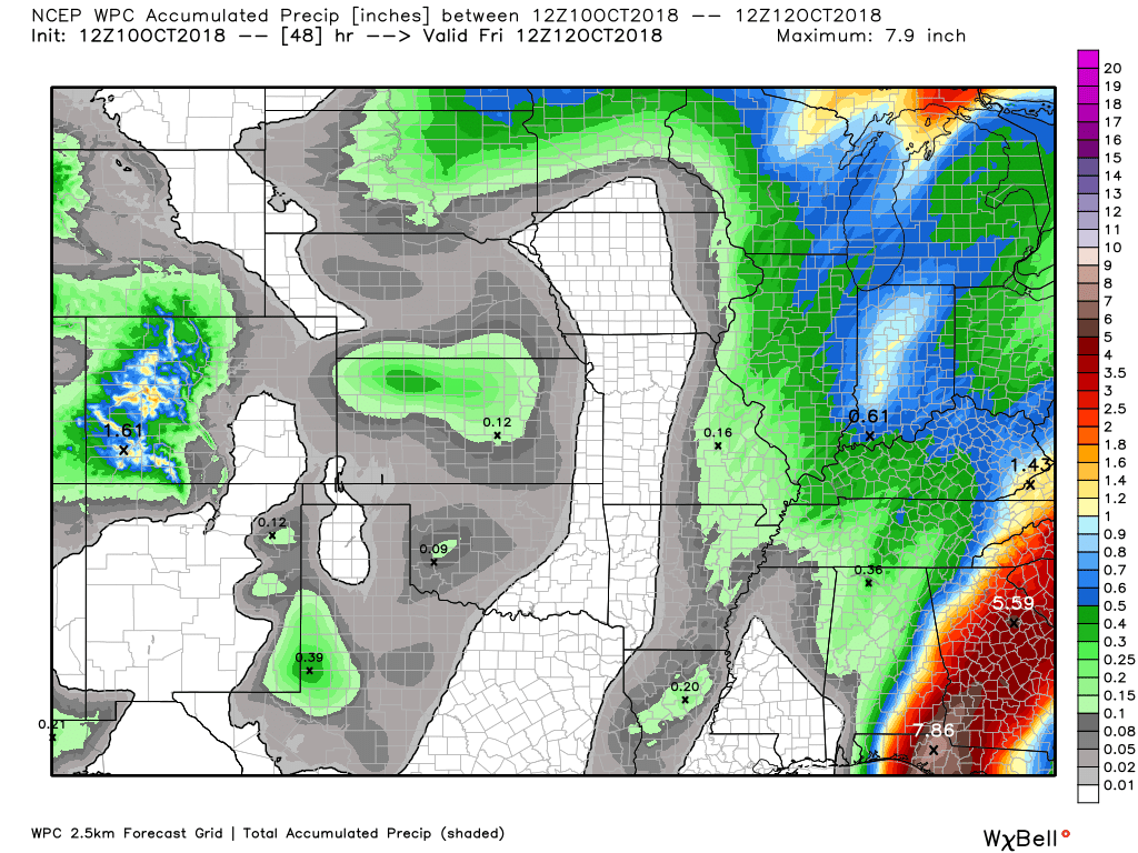
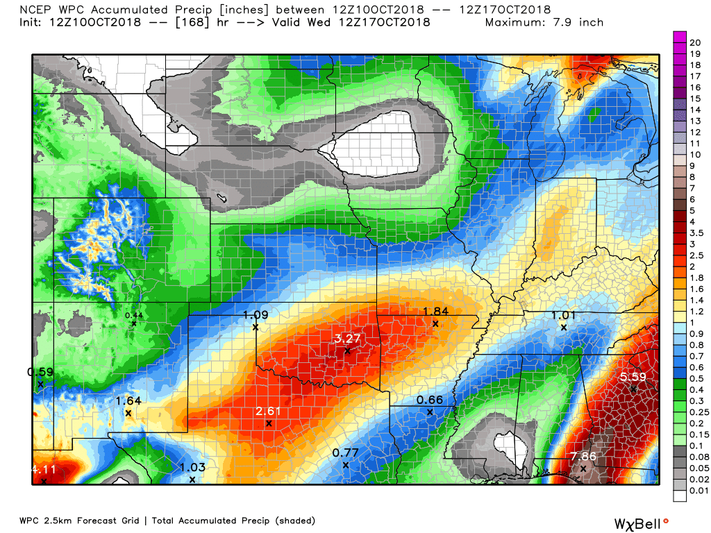
A second rain event is forecast Saturday night and especially on Sunday and Sunday night. A few spotty showers may remain into Monday.
When you add that event with the first event you could receive these totals.
Some of the guidance paints heavy rain in the region Sunday. I will be monitoring trends in the guidance.
Again, click to enlarge the image.
Did you know that you can find me on Twitter?

Need a forecast for an outdoor event?


We offer interactive local city live radars and regional radars.
If a radar does not update then try another one. If a radar does not appear to be refreshing then hit Ctrl F5 on your keyboard.
You may also try restarting your browser. The local city view radars also have clickable warnings.
During the winter months, you can track snow and ice by clicking the winterize button on the local city view interactive radars.

Questions? Broken links? Other questions?
You may email me at beaudodson@usawx.com

The National Weather Service defines a severe thunderstorm as one that produces quarter size hail or larger, 58 mph winds or greater, and/or a tornado.
Today and tonight: A cold front will push through the region with showers and thunderstorms. A few storms could produce strong and gusty winds. Lightning, of course, is a concern for those outdoors. The risk of severe weather is low.
Thursday through Monday: Severe weather is not anticipated. I am monitoring rain chances Saturday night into Sunday night. I can’t rule out thunderstorms, but that will be dependent on the track of the area of low pressure.
Interactive live weather radar page. Choose the city nearest your location. If one of the cities does not work then try a nearby one. Click here.
National map of weather watches and warnings. Click here.
Storm Prediction Center. Click here.
Weather Prediction Center. Click here.

Live lightning data: Click here.

Interactive GOES R satellite. Track clouds. Click here.

Here are the latest local river stage forecast numbers Click Here.
Here are the latest lake stage forecast numbers for Kentucky Lake and Lake Barkley Click Here.

- Showers and thunderstorm chances today into tonight
- Much cooler air arrives
- Another rainmaker Saturday night into Monday
- Hurricane Michael moves ashore
The big weather story today is the rain showers and thunderstorms. The next weather story will be much cooler temperatures. It is finally going to feel like autumn.
Weather Radar Link
http://weatherobservatory.com/weather-radar.htm
We will have scattered showers and thunderstorms in the region today. A broken line of storms has been pushing through the area. Severe weather is not a concern today. Some brief downpours possible. No major concerns.
The rain will wind down as we move through this evening. The rain will end from west to east.
Cooler weather will prevail today through at least next Wednesday.
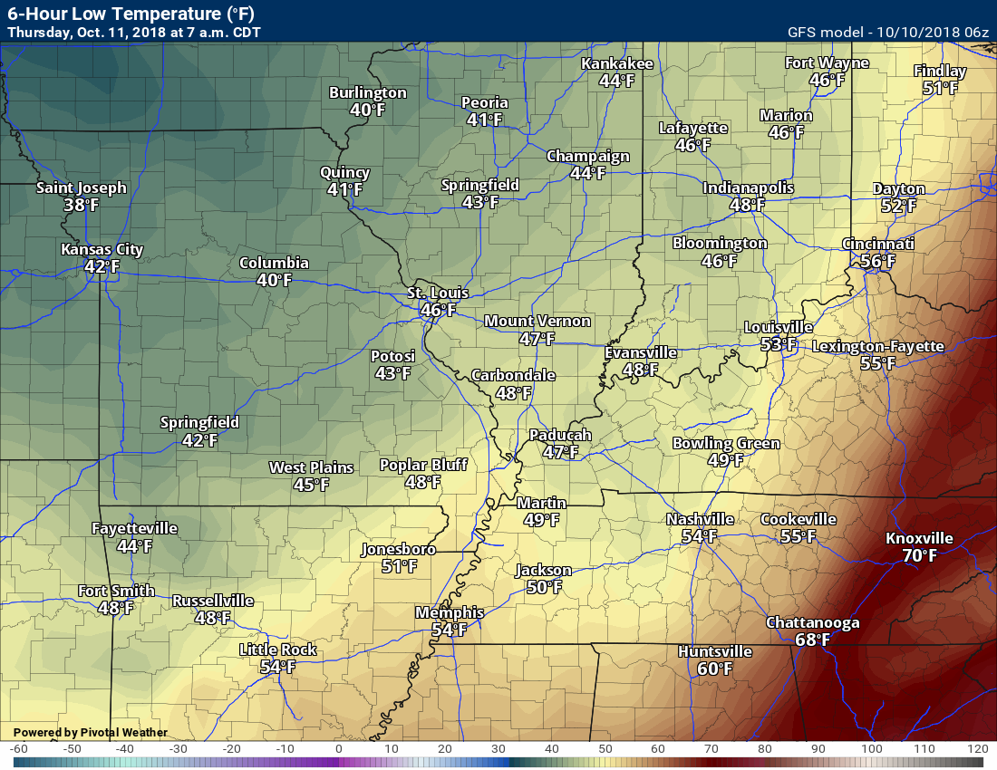
Check out some of these morning low temperatures being forward by the GFS.
The GFS has a bit of a cold bias in the long range. Frost chances can’t be ruled out, but confidence isn’t high enough yet to place it in the forecast.
Thursday morning lows
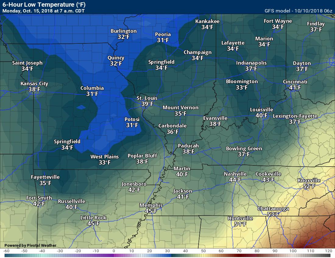
Even colder temperatures will arrive early next week behind another cold front.
Here is the Monday morning GFS model temperature forecast
Here is the Tuesday morning GFS model temperature forecast
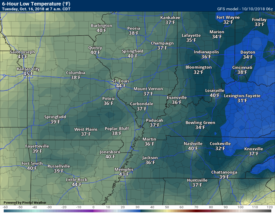
High temperatures over the coming days will mostly be in the 60’s. A streak of below normal temperature days.
A weak disturbance will push through the region Friday afternoon and Friday night. Some increase in clouds will be the end result. Models are also showing a few light showers over southeast Missouri and southwest Illinois. Lesser chances in west Kentucky and northwest Tennessee. I increased probabilities slightly.
I am monitoring Friday night temperatures. Frost seems unlikely, but monitor updates. If temperatures are a bit colder then frost could occur. Light frost.
Another cold front will arrive Saturday night into Monday. This system will bring additional rain to the region.
There is a chance of some heavy downpours, but that will be highly dependent on the track of an area of low pressure. At this time, severe weather appears unlikely. I will keep monitoring trends. Wind fields will be stronger aloft. That can sometimes equal strong to severe thunderstorms.
The coolest air of the season, thus far, will arrive Sunday night into Tuesday night.
Frost is possible Monday and Tuesday night. Monitor updates.
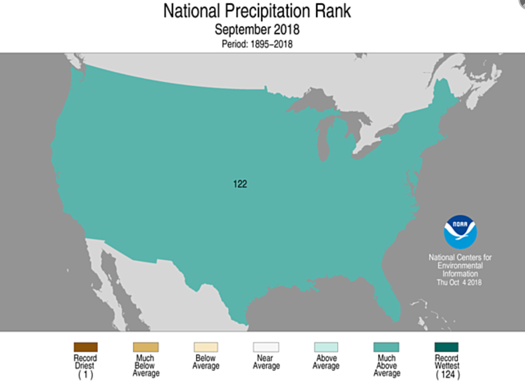
The September climate records have been posted.
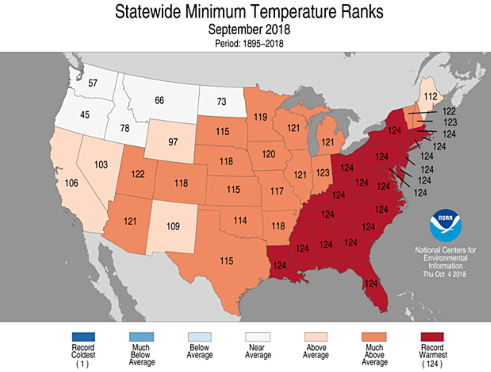
These go back 124 years. That means if the graphic says 124 that we hit a new record. If it says 123 then September ranked second in that category.
It was the fourth warmest on the national average temperature rank. Quite warm.
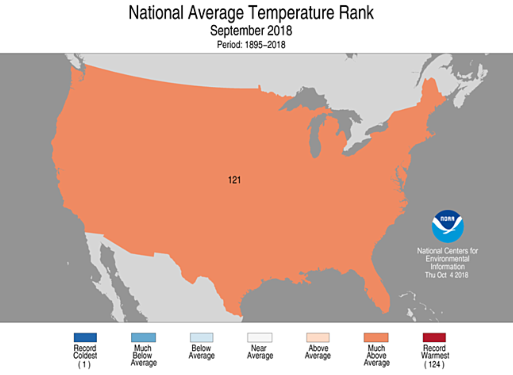
It was the second warmest when it came to national low-temperature rankings. The nights were very warm across the nation.

As far as precipitation rankings, the nation ranked the third wettest since 1895. Quite wet! Not quite a number one ranking, but close.
On a regional scale, portions of our region had their warmest September since 1895. Where you see number 124 is where it ranked first.
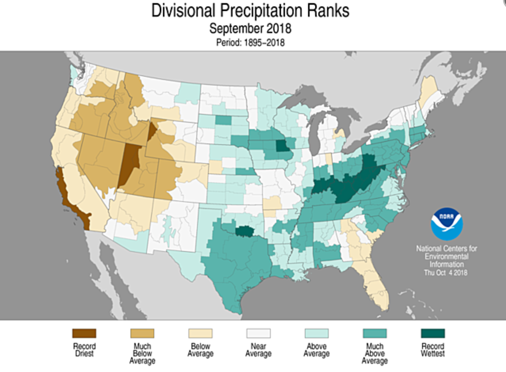
Let’s look at divisional precipitation rankings. Portions of southern Indiana and eastern Kentucky had their wettest September on record.
Most of the rest of the region did average above normal when it came to rain totals.
Michael is a category four
Strongest hurricane in recorded history in that particular area.
Monitor updates from local officials/television meteorologists concerning this storm. The local meteorologists along the Gulf of Mexico will certainly be talking about this.
National Hurricane Center Lik to their homepage – click here
AGAIN SEE THE LATEST AT THE LINK ABOVE
THESE GRAPHICS ARE TIME-SENSITIVE
![]()
Bonus VIDEO UPDATES
These are bonus videos and maps for subscribers. I bring these to you from the BAMwx team. I pay them to help with videos.
The Ohio and Missouri Valley videos cover most of our area. They do not have a specific Tennessee Valley forecast but may add one in the future.
The long-range video is technical. Over time, you can learn a lot about meteorology from the long range video. Just keep in mind, it is a bit more technical.
Here is the current track forecast of that hurricane. The end result here would be rain. No concerns about wind.
![]()
Here is the preliminary fall outlook from the long-range meteorology team.
Click to enlarge this graphic.
.
![]()
The September forecast has been updated.
![]()

I bring these to you from the BAMwx team. They are excellent long-range forecasters.
Remember, long-range outlooks are a bit of skill, understanding weather patterns, and luck combined. It is not an exact science.

This product is for subscribers.
Subscribe at www.weathertalk.com
Subscriber graphics can be viewed on this page CLICK HERE

This product is for subscribers.

Subscriber graphics can be viewed on this page CLICK HERE
![]()
.
Fall Outlook!
Preliminary October precipitation outlook
Here is the preliminary November temperature and precipitation outlook
Preliminary November temperature outlook
Preliminary November precipitation outlook
.These products are for subscribers.
![]()

A new weather podcast is now available! Weather Geeks (which you might remember is on The Weather Channel each Sunday)
To learn more visit their website. Click here.
![]()

WeatherBrains Episode 663
Joining us as our Guest WeatherBrain this week is a hydrologist in the Research Applications Lab at NCAR. He has a background in hydrology, geology and computer science. In graduate school, he found a happy marriage of these in hydrological modeling, remote sensing, and more recently atmospheric modeling. Ethan Gutmann, welcome to WeatherBrains!
Other discussions in this weekly podcast include topics like:
- Should we re-do hurricane classification?
- Ethan’s hobby of mountain climbing
- U. S. Weather Roundup
- Remnants of Hurricane Rosa entering SW United States
- Astronomy Outlook with Tony Rice
- and more!
.
.
Link to their website https://weatherbrains.com/
Previous episodes can be viewed by clicking here.

We offer interactive local city live radars and regional radars. If a radar does not update then try another one. If a radar does not appear to be refreshing then hit Ctrl F5. You may also try restarting your browser.
The local city view radars also have clickable warnings.
During the winter months, you can track snow and ice by clicking the winterize button on the local city view interactive radars.
You may email me at beaudodson@usawx.com
Find me on Facebook!

Find me on Twitter!

Did you know that a portion of your monthly subscription helps support local charity projects?
You can learn more about those projects by visiting the Shadow Angel Foundation website and the Beau Dodson News website.

I encourage subscribers to use the app vs regular text messaging. We have found text messaging to be delayed during severe weather. The app typically will receive the messages instantly. I recommend people have three to four methods of receiving their severe weather information.
Remember, my app and text alerts are hand typed and not computer generated. You are being given personal attention during significant weather events.
