WeatherTalk monthly operating costs can top $2000.00. Your $5 subscription helps pay for those costs. I work for you.
The $5 will allow you to register up to seven phones!
For $5 a month you can receive the following. You may choose to receive these via your WeatherTalk app or regular text messaging.
Severe weather app/text alerts from my keyboard to your app/cell phone. These are hand typed messages from me to you. During tornado outbreaks, you will receive numerous app/text messages telling you exactly where the tornado is located.
- Daily forecast app/texts from my computer to your app/cell phone.
- Social media links sent directly to your app/cell phone. When I update the blog, videos, or Facebook you will receive the link.
- AWARE emails. These emails keep you well ahead of the storm. They give you several days of lead time before significant weather events.
- Direct access to Beau via text and email. Your very own personal meteorologist. I work for you!
- Missouri and Ohio Valley centered video updates
- Long-range weather videos
- Week one, two, three and four temperature and precipitation outlooks.
Monthly outlooks. - Your subscription also will help support several local charities.
Would you like to subscribe? Subscribe at www.beaudodsonweather.com

I encourage subscribers to use the app vs regular text messaging. We have found text messaging to be delayed during severe weather. The app typically will receive the messages instantly. I recommend people have three to four methods of receiving their severe weather information.
Remember, my app and text alerts are hand typed and not computer generated. You are being given my personal attention during significant weather events.

WWW.WEATHERTALK.COM subscribers, here is my day to day schedule for your weather products.
These are bonus videos and maps for subscribers. I bring these to you from the BAMwx team. I pay them to help with videos.
The Ohio and Missouri Valley videos cover most of our area. They do not have a specific Tennessee Valley forecast but may add one in the future.
The long-range video is technical. Over time, you can learn a lot about meteorology from the long range video. Just keep in mind, it is a bit more technical.


October 01, 2018
Monday Forecast Details
Patchy dense fog this morning. Use care.
Forecast: A mix of sun and clouds as a weak disturbance approaches from the southwest. A shower or thunderstorm possible. Warm and becoming more humid.
Temperatures: MO ~ 82 to 86 IL ~ 82 to 86 KY ~ 84 to 86 TN ~ 84 to 86
What is the chance of precipitation? MO ~ 30% IL ~ 20% KY ~ 30% TN ~ 30%
Coverage of precipitation: Widely scattered
Wind: South and southeast at 5 to 10 mph
What impacts are anticipated from the weather? A few wet roadways. An isolated lightning strike possible.
My confidence in the forecast verifying: High
Is severe weather expected? No
The NWS defines severe weather as 58 mph wind or great, 1″ hail or larger, and/or tornadoes
Should I cancel my outdoor plans? No, but glance at the radars
UV Index: 6 High
Sunrise: 6:51 AM
Interactive Radars:
Interactive live weather radar page. Choose the city nearest your location. If one of the city radars won’t load then try a nearby one. Click here.
Monday Night Forecast Details:
Forecast: Some clouds. Some scattered showers and perhaps a thunderstorm. Highest chances will be over western Kentucky and Tennessee. Greater chances as you move south and east. Patchy fog possible. Mild and humid.
Temperatures: MO ~ 64 to 68 IL ~ 64 to 68 KY ~ 64 to 68 TN ~ 64 to 68
What is the chance of precipitation? MO ~ 20% IL ~ 30% KY ~ 40% TN ~ 30%
Coverage of precipitation: Widely scattered
Wind: South and southwest at 4 to 8 mph
What impacts are anticipated from the weather? Scattered wet roadways. Lower visibility if fog forms.
My confidence in the forecast verifying: Medium
Is severe weather expected? No
The NWS defines severe weather as 58 mph wind or great, 1″ hail or larger, and/or tornadoes
Should I cancel my outdoor plans? No
Sunset: 6:39 PM
Moonrise:11:30 PM Waning Gibbous
Moonset: 1:20 PM
October 02, 2018
Tuesday Forecast Details
Forecast: Partly cloudy. Warm and humid. A widely scattered shower or thundershower possible. Greatest chances over eastern portions of western Kentucky. That would mean the Pennyrile area.
Temperatures: MO ~ 84 to 86 IL ~ 84 to 86 KY ~ 83 to 86 TN ~ 84 to 88
What is the chance of precipitation? MO ~ 20% IL ~ 30% KY ~ 40% TN ~ 30%
Coverage of precipitation: Widely scattered to scattered
Wind: South at 4 to 8 mph
What impacts are anticipated from the weather? Scattered wet roadways. A stray lightning strike possible.
My confidence in the forecast verifying: Medium
Is severe weather expected? No
The NWS defines severe weather as 58 mph wind or great, 1″ hail or larger, and/or tornadoes
Should I cancel my outdoor plans? No, but glance at the radars
UV Index: 5 Moderate
Sunrise: 6:52 AM
Tuesday Night Forecast Details:
Forecast: Partly cloudy. Any remaining showers will come to an end. Mild. Patchy fog possible.
Temperatures: MO ~ 66 to 68 IL ~ 66 to 68 KY ~ 66 to 70 TN ~ 66 to 70
What is the chance of precipitation? MO ~ 10% mainly early IL ~ 20% mainly early KY ~ 20% mainly early TN ~ 20% mainly early
Coverage of precipitation: Ending early
Wind: South at 3 to 6 mph
What impacts are anticipated from the weather? Lower visibility if fog forms.
My confidence in the forecast verifying: Medium
Is severe weather expected? No
The NWS defines severe weather as 58 mph wind or great, 1″ hail or larger, and/or tornadoes
Should I cancel my outdoor plans? No
Sunset: 6:37 PM
Moonrise: 11:59 PM Last Quarter
Moonset: 2:20 PM
October 03, 2018
Wednesday Forecast Details
Forecast: Partly to mostly sunny. Warm. Humid. Summer-like. Breezy, at times.
Temperatures: MO ~ 86 to 88 IL ~ 86 to 88 KY ~ 86 to 88 TN ~ 86 to 88
What is the chance of precipitation? MO ~ 20% IL ~ 20% KY ~ 20% TN ~ 20%
Coverage of precipitation: None to isolated
Wind: South and southwest at 10 t0 20 mph. Strongest winds over southeast Missouri and southern Illinois.
What impacts are anticipated from the weather? Most likely none. An isolated wet roadway and isolated lightning.
My confidence in the forecast verifying: Medium
Is severe weather expected? No
The NWS defines severe weather as 58 mph wind or great, 1″ hail or larger, and/or tornadoes
Should I cancel my outdoor plans? No, but check radars
UV Index: 6 High
Sunrise: 6:53 AM
Wednesday Night Forecast Details:
Forecast: A few clouds. Mild.
Temperatures: MO ~ 68 to 72 IL ~ 68 to 72 KY ~ 68 to 72 TN ~ 68 to 72
What is the chance of precipitation? MO ~ 10% IL ~ 10% KY ~ 0% TN ~ 0%
Coverage of precipitation: Most likely none
Wind: South and southwest at 6 to 12 mph
What impacts are anticipated from the weather? None
My confidence in the forecast verifying: High
Is severe weather expected? No
The NWS defines severe weather as 58 mph wind or great, 1″ hail or larger, and/or tornadoes
Should I cancel my outdoor plans? No
Sunset: 6:36 PM
Moonrise: 12:30 AM Waning Crescent
Moonset: 3:15 PM
October 04, 2018
Thursday Forecast Details
Forecast: Partly to mostly sunny. Dry across most of the region. A few showers or thunderstorms possible (mainly across our northern counties). Greatest chance along I64 with increasing chances north of there.
Temperatures: MO ~ 82 to 84 IL ~ 82 to 84 KY ~ 82 to 84 TN ~ 82 to 84
What is the chance of precipitation? MO ~ 30% (mainly north) IL ~ 20% south of I64 and 40% along and north of I64 KY ~ 10% TN ~ 10%
Coverage of precipitation: Scattered (mainly our northern counties)
Wind: South and southwest at 6 to 12 mph
What impacts are anticipated from the weather? Northern counties may have some wet roadways. Isolated lightning.
My confidence in the forecast verifying: Medium
Is severe weather expected? No
The NWS defines severe weather as 58 mph wind or great, 1″ hail or larger, and/or tornadoes
Should I cancel my outdoor plans? No
UV Index: 6 High
Sunrise: 6:53 AM
Thursday Night Forecast Details:
Forecast: Partly cloudy. Mild. Dry across most of the region. A few showers or thunderstorms possible (mainly across our northern counties). Greatest chance along I64 with increasing chances north of there.
Temperatures: MO ~ 66 to 70 IL ~ 66 to 70 KY ~ 68 to 70 TN ~ 68 to 70
What is the chance of precipitation? MO ~ 20% IL ~ 30% (north) and 20% south KY ~ 10% TN ~ 10%
Coverage of precipitation: Isolated to widely scattered (mainly along and north of I64)
Wind: South at 5 to 10 mph
What impacts are anticipated from the weather? Spotty wet roadways and lightning (most likely along and north of I64)
My confidence in the forecast verifying: Medium
Is severe weather expected? No
The NWS defines severe weather as 58 mph wind or great, 1″ hail or larger, and/or tornadoes
Should I cancel my outdoor plans? No
Sunset: 6:34 PM
Moonrise: 1:35 AM Waning Crescent
Moonset: 4:04 PM
October 05, 2018
Friday Forecast Details
Forecast: Mostly sunny. A few afternoon clouds.
Temperatures: MO ~ 84 to 88 IL ~ 84 to 88 KY ~ 84 to 88 TN ~84 to 88
What is the chance of precipitation? MO ~ 10% IL ~ 10% KY ~ 10% TN ~ 10%
Coverage of precipitation: Most likely none. I will be monitoring areas along a line from Poplar Bluff, Missouri, to Mt Vernon, Illinois.
Wind: South at 5 to 10 mph with gusts to 14 mph
What impacts are anticipated from the weather? Most likely none.
My confidence in the forecast verifying: Medium
Is severe weather expected? No
The NWS defines severe weather as 58 mph wind or great, 1″ hail or larger, and/or tornadoes
Should I cancel my outdoor plans? No, but monitor updates
UV Index: 6 High
Sunrise: 6:54 AM
Friday Night Forecast Details:
Forecast: Partly cloudy. Most of the area should remain dry. A chance of a shower or thunderstorm. Greatest chances over southeast Missouri and southern Illinois
Temperatures: MO ~ 66 to 70 IL ~ 66 to 70 KY ~ 66 to 70 TN ~ 66 to 7o
What is the chance of precipitation? MO ~ 30% IL ~ 30% KY ~ 20% TN ~ 10%
Coverage of precipitation: Scattered mainly over southeast Missouri and southern Illinois. Especially true as you move west and north.
Wind: South at 5 to 10 mph
What impacts are anticipated from the weather? Scattered wet roadways and lightning. Again, mainly over southeast Missouri and southern Illinois. The further north and west you travel the greater the chance of a few showers and storms.
My confidence in the forecast verifying: Medium
Is severe weather expected? No
The NWS defines severe weather as 58 mph wind or great, 1″ hail or larger, and/or tornadoes
Should I cancel my outdoor plans? No, but glance at the radars
Sunset: 6:33 PM
Moonrise: 4:48 PM Waning Crescent
Moonset: 2:43 AM
October 06, 2018
Saturday Forecast Details
Forecast: Partly sunny. Warm and humid. Most of the area may remain dry. A chance of a shower or thunderstorm, especially western and northern counties from Poplar Bluff, Missouri, towards Mt Vernon, Illinois.
Temperatures: MO ~83 to 86 IL ~ 83 to 80 KY ~ 83 to 86 TN ~ 83 to 86
What is the chance of precipitation? MO ~ 30% IL ~ 30% KY ~ 20% TN ~ 20%
Coverage of precipitation: None to scattered
Wind: South at 7 to 14 mph
What impacts are anticipated from the weather? Wet roadways. Lightning. Greater chances over southeast Missouri and southern Illinois. Most of the area may remain dry if the front doesn’t push its way into the area.
My confidence in the forecast verifying: Medium
Is severe weather expected? Not at this time
The NWS defines severe weather as 58 mph wind or great, 1″ hail or larger, and/or tornadoes
Should I cancel my outdoor plans? I would monitor updates and radars. There could be some precipitation in the region.
UV Index: 6 High
Sunrise: 6:55 AM
Saturday Night Forecast Details:
Forecast: Partly to mostly cloudy. A chance of a shower or thunderstorm. Especially western and northern counties from Poplar Bluff, Missouri, towards Mt Vernon, Illinois.
Temperatures: MO ~ 63 to 66 IL ~ 63 to 66 KY ~ 64 to 68 TN ~ 64 to 68
What is the chance of precipitation? MO ~ 30% IL ~ 30% KY ~ 20% TN ~ 20%
Coverage of precipitation: Scattered
Wind: South and southeast at 5 to 10 mph with gusts to 14 mph
What impacts are anticipated from the weather? Wet roadways. Lightning possible.
My confidence in the forecast verifying: LOW
Is severe weather expected? No
The NWS defines severe weather as 58 mph wind or great, 1″ hail or larger, and/or tornadoes
Should I cancel my outdoor plans? Monitor updates.
Sunset: 6:31 PM
Moonrise: 3:53 AM Waning Crescent
Moonset: 5:27 PM
October 07, 2018
Sunday Forecast Details
Forecast: Partly sunny. A shower or thunderstorm possible.
Temperatures: MO ~ 80 to 85 IL ~ 80 to 85 KY ~ 80 to 85 TN ~ 80 to 85
What is the chance of precipitation? MO ~ 40% IL ~ 30% KY ~ 20% TN ~ 20%
Coverage of precipitation: Scattered
Wind: South and southeast winds at 5 to 10 mph with gusts to 16 mph
What impacts are anticipated from the weather? A few wet roadways possible. Isolated lightning.
My confidence in the forecast verifying: LOW
Is severe weather expected? Unlikely
The NWS defines severe weather as 58 mph wind or great, 1″ hail or larger, and/or tornadoes
Should I cancel my outdoor plans? No, but monitor updates
UV Index: 5 Moderate
Sunrise: 6:56 AM
Sunday Night Forecast Details:
Forecast: Partly cloudy. A chance of showers and thunderstorms. This is highly dependent on the placement of the cold front to our north and west.
Temperatures: MO ~ 64 to 68 IL ~ 64 to 68 KY ~ 64 to 68 TN ~ 64 to 68
What is the chance of precipitation? MO ~ 30% IL ~ 30% KY ~ 30% TN ~ 30%
Coverage of precipitation: Scattered
Wind: North and northeast at 4 to 8 mph
What impacts are anticipated from the weather? Scattered wet roadways and lightning.
My confidence in the forecast verifying: Medium
Is severe weather expected? Unlikely
The NWS defines severe weather as 58 mph wind or great, 1″ hail or larger, and/or tornadoes
Should I cancel my outdoor plans? Monitor updates
Sunset: 6:30 PM
Moonrise: 5:03 AM Waning Crescent
Moonset: 6:04 PM
October 08, 2018
Monday forecast: Partly cloudy. Mild. A chance of showers and thunderstorms.
Temperatures: MO ~ 82 to 86 IL ~ 82 to 86 KY ~ 82 to 86 TN ~ 82 to 86
What is the chance of precipitation? MO ~ 30% IL ~ 30% KY ~ 30% TN ~ 30%
Coverage of precipitation: Scattered
Wind: South and southwest at 6 to 12 mph
What impacts are anticipated from the weather? Wet roadways and lightning.
My confidence in the forecast verifying: LOW
Is severe weather expected? Unlikely
The NWS defines severe weather as 58 mph wind or great, 1″ hail or larger, and/or tornadoes
Should I cancel my outdoor plans? Monitor updates
UV Index: 6 High
Sunrise: 6:57 AM
Monday Night Forecast Details:
Forecast: Partly cloudy. A chance of showers and thunderstorms.
Temperatures: MO ~ 62 to 66 IL ~ 62 to 66 KY ~ 62 to 66 TN ~ 62 to 66
What is the chance of precipitation? MO ~ 30% IL ~ 30% KY ~ 30% TN ~ 30%
Coverage of precipitation: Scattered
Wind: Southwest and west at 6 to 12 mph
What impacts are anticipated from the weather? Wet roadways. Lightning.
My confidence in the forecast verifying: LOW
Is severe weather expected? No
The NWS defines severe weather as 58 mph wind or great, 1″ hail or larger, and/or tornadoes
Should I cancel my outdoor plans? Monitor updates
Sunset: 6:28 PM
Moonrise: 6:12 AM Waning Crescent
Moonset: 6:38 PM
Learn more about the UV index readings. Click here.

Here is the latest WPC/NOAA rainfall outlook.
This graphic will take us through next Monday morning.
The WPC/NOAA has painted fairly light totals. The big question locally will be the placement of a cold front later this week.
Before that time, we will have a few showers and thunderstorms today into Thursday. Many areas will remain dry. Perhaps a bit more coverage over western Kentucky and Tennessee late tonight into Tuesday. See probability numbers above.
Medium confidence in the precipitation forecast.
Notice the heavy band of rain from Texas into Wisconsin. That is in response to a frontal boundary and tropical moisture. Most of the model guidance keeps this heavy rain to our northwest.
Click to enlarge
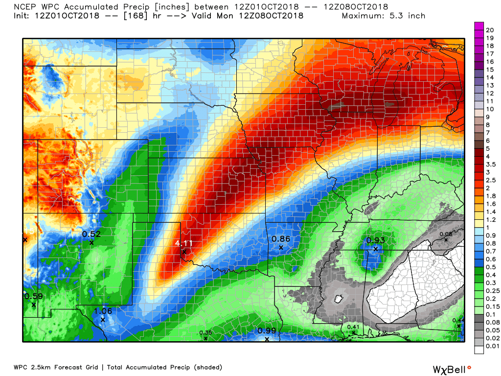
We do not need rain. Well, most of us don’t need rain.
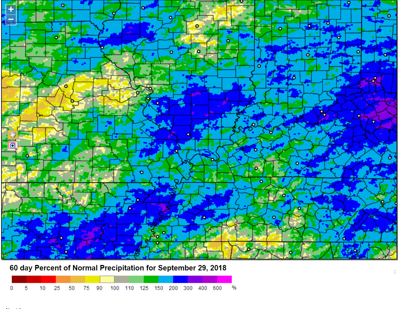
Here is the latest 60-day precipitation anomaly. Well above normal across portions of the region.
Click to enlarge.
You can see Missouri, Illinois, Kentucky, and Tennessee (black outlines)
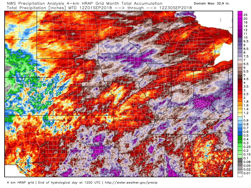
Here are the NWS radar estimates of rainfall from September 1st through the 30th.
Click to enlarge. Look at some of those totals! Much of that fell the second half of the month.
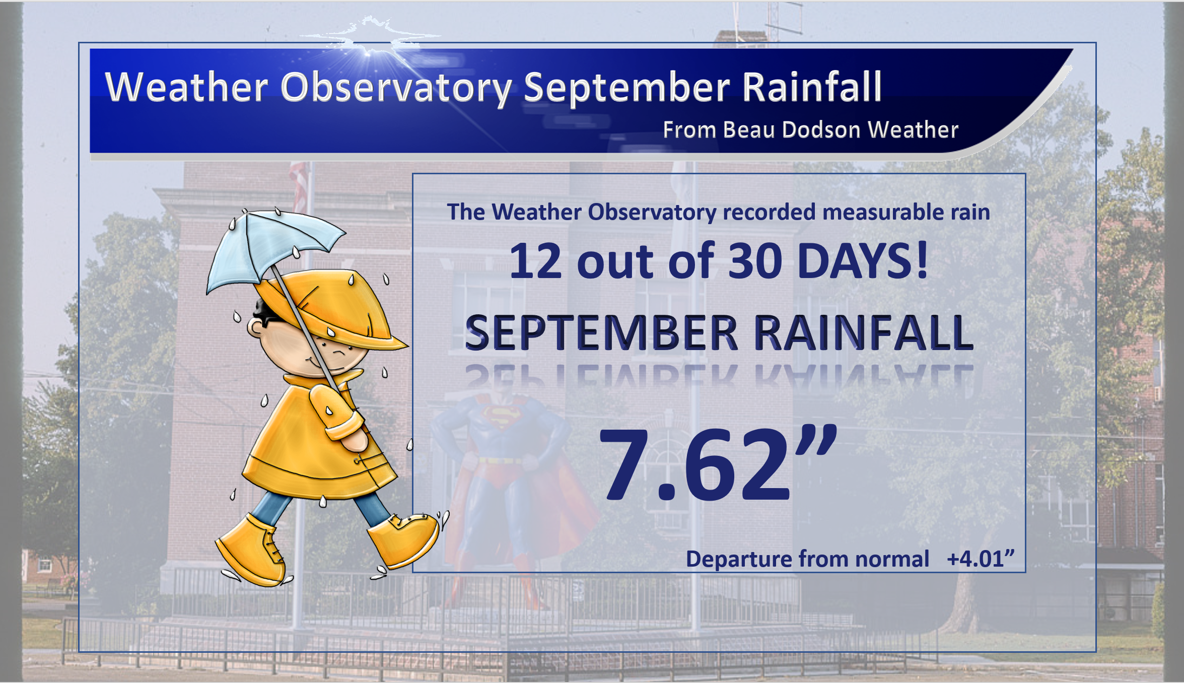
Well above normal precipitation was recorded at the Weather Observatory in Massac County, Illinois.
It rained twelve days out of thirty.
Need a forecast for an outdoor event?


We offer interactive local city live radars and regional radars.
If a radar does not update then try another one. If a radar does not appear to be refreshing then hit Ctrl F5 on your keyboard.
You may also try restarting your browser. The local city view radars also have clickable warnings.
During the winter months, you can track snow and ice by clicking the winterize button on the local city view interactive radars.

Questions? Broken links? Other questions?
You may email me at beaudodson@usawx.com

The National Weather Service defines a severe thunderstorm as one that produces quarter size hail or larger, 58 mph winds or greater, and/or a tornado.
Today through Thursday: A few thunderstorms will be possible into Thursday. This will be in response to a weak vort max (area of lift) moving out of northeast Texas and Oklahoma. Another weak disturbance will pass through the region during the middle of the week.
Severe weather is not anticipated.
Friday through Sunday: Severe weather is not anticipated. A cold front will approach the region Friday night into Saturday night. This front could set off a few thunderstorms. Lightning will be the concern.
Interactive live weather radar page. Choose the city nearest your location. If one of the cities does not work then try a nearby one. Click here.
National map of weather watches and warnings. Click here.
Storm Prediction Center. Click here.
Weather Prediction Center. Click here.

Live lightning data: Click here.

Interactive GOES R satellite. Track clouds. Click here.

Here are the latest local river stage forecast numbers Click Here.
Here are the latest lake stage forecast numbers for Kentucky Lake and Lake Barkley Click Here.

- Warm week ahead.
- A few scattered showers and thunderstorms.
- Watching a weekend cold front.
Graphics have been updated. Monday morning at 8 AM
I had a great vacation! I came back re-energized and ready for the fall severe weather uptick and then winter!
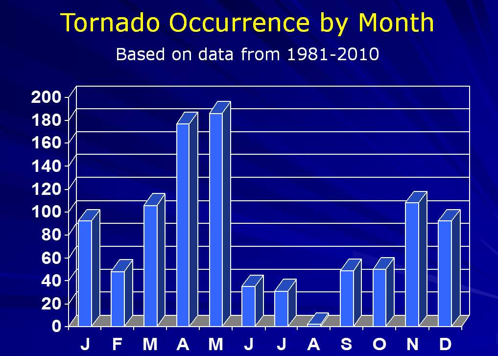
We typically do have severe storms during October and November. Some of our deadlier tornado events have actually occurred during these two months. I will keep an eye on the charts as we change seasons.
I found this image online. Just to give you an example. This is for the State of Arkansas. The same applies locally. An uptick in severe weather is not uncommon during the autumn months.
The week ahead.
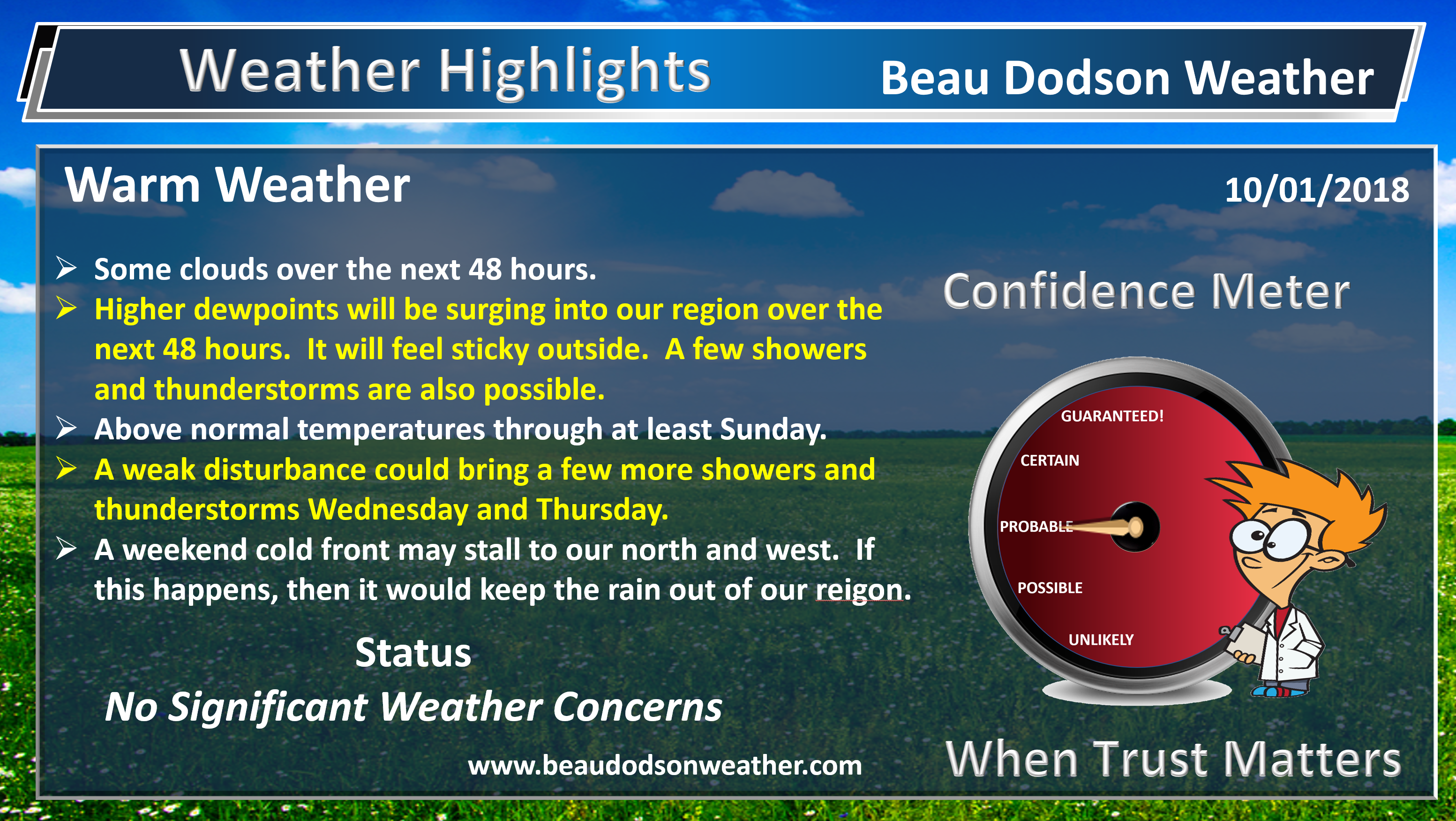
The big weather story this week will be the warm and humid weather. Well above normal temperatures.
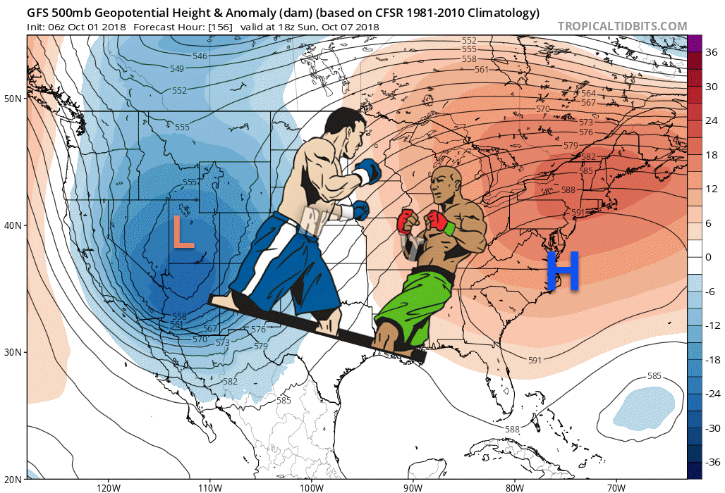
I am closely monitoring a cold front that will attempt to push into the region Friday into Monday. It will battle the high-pressure center to our southeast.
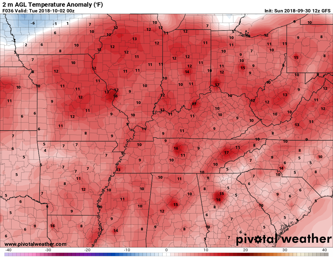
A warm week of weather ahead of us. Today into Wednesday will likely be the warmest days. Clouds today could keep temperatures down a bit. Expect lower to middle 80’s across the region. This is several degrees above the normal high temperature of 78 degrees.
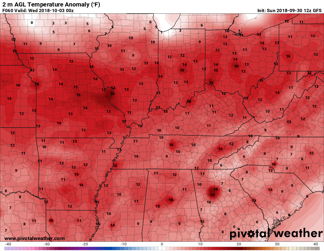
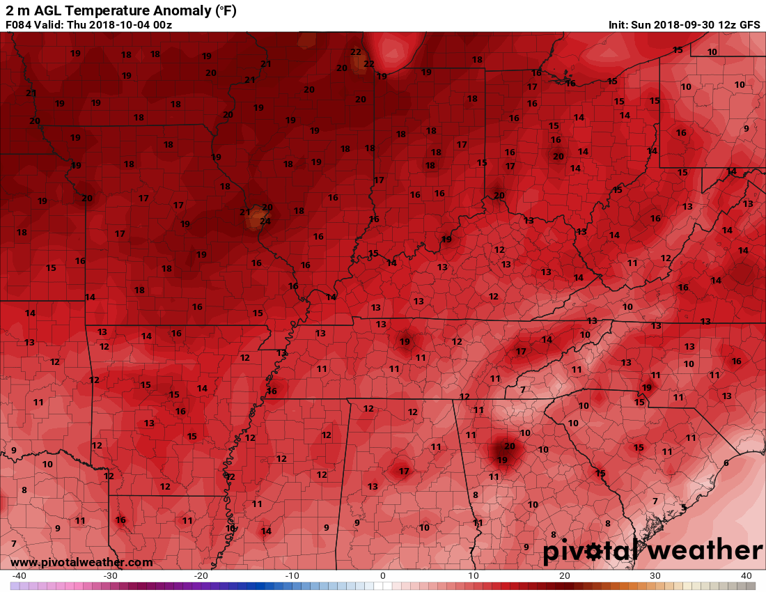
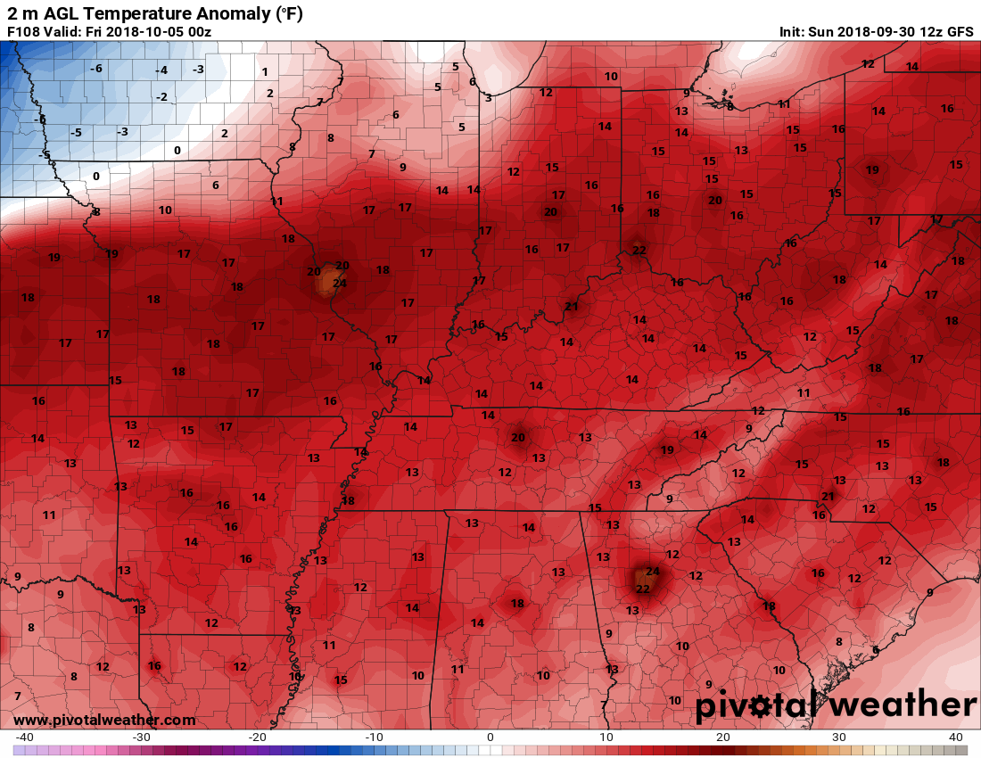
Here is the temperature anomaly map for Monday, Tuesday, Wednesday, and Thursday. Well above normal.
This shows you how many degrees above normal temperatures are expected to be.
Tuesday
Wednesday
Thursday
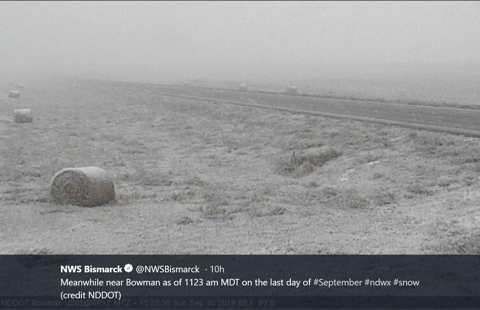
If you are tired of the warm weather, then you could travel to North Dakota. This was the scene yesterday. Snow!
A weak storm system will pass through the region Monday. This will deliver some clouds and perhaps a couple of showers or thunderstorms. Overall, it appears most of us will miss the rain showers.
You can see that system on the NAM model. This shows you an area of lift. I circled it in white.
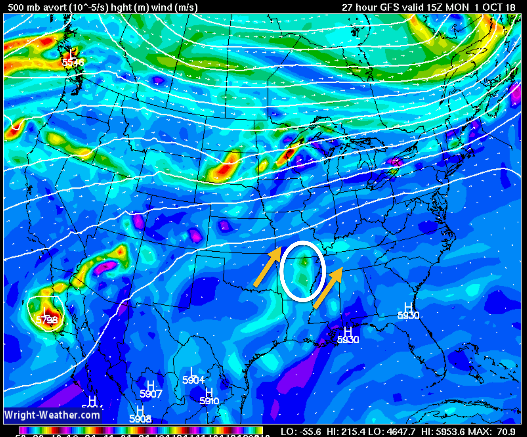
The system will push off to the north and northeast Monday night.
Tuesday, another weak system could bring a few more showers and thunderstorms. Again, most of the region will remain dry.
Another disturbance will pass through the region Wednesday and Thursday. A few showers and thunderstorms will form along a boundary. There remain some questions about the placement of the boundary. It is possible that the greatest chance will be across our northern counties. Northern portions of southeast Missouri and northern portions of southern Illinois.
A late week cold front. It may stall to our northwest.
Low to medium confidence in the Friday night into Monday weather outlook.
A cold front will attempt to push into the region late this week. It appears that the front will not make it into our local area.
The front may be close enough to cause an increase in rain and thunderstorm chances Friday night into Sunday. The odds would favor our western and northern counties. That would run from Poplar Bluff, Missouri, towards Mt Vernon, Illinois. Even there, there are questions about whether the front will be close enough to spark precipitation. For now, I kept rain chances low. I will continue to monitor trends.
Some of the models show no rain Friday night into Saturday. I would not make any changes to your weekend plans, just yet.
No solid cold shots in the forecast (through Tuesday).
Severe weather is not anticipated this week. As always, monitor updates. A few lightning strikes are possible.
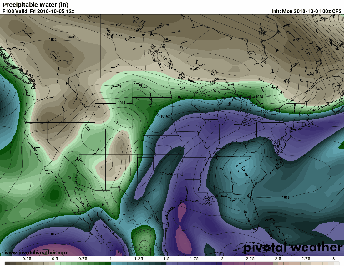
The Candian model is showing high PWAT values training over the same areas this week. That would mostly be to our west and northwest.
It is tapping into very high PWAT values from the hurricane in the Pacific and then a large feed from the Gulf of Mexico. This needs to be monitored. It would spell heavy rain for some areas.
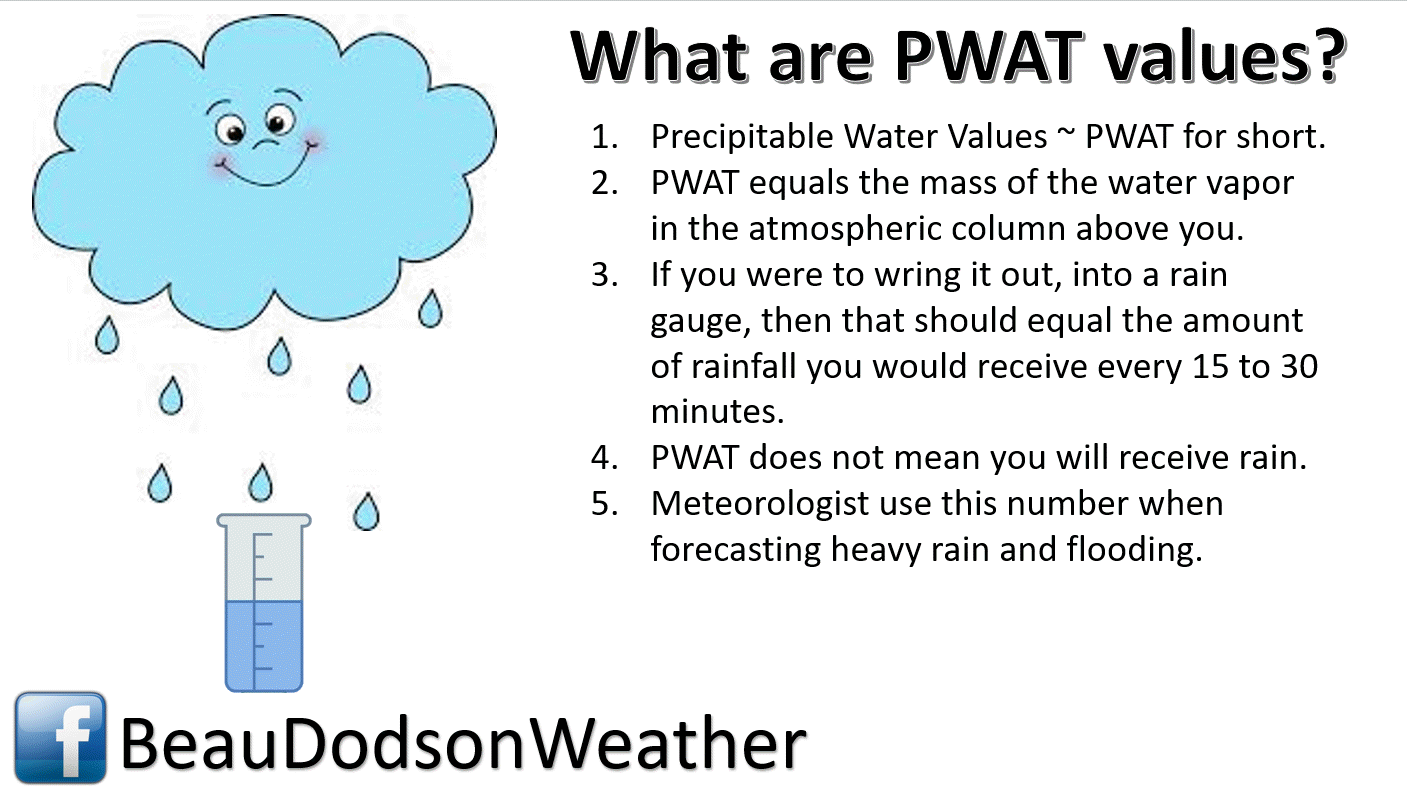
What are PWAT’s?
Click to enlarge the animati0n. You are looking at PWAT values.
The placement of the front boundary late this week into next week will be key to where the heavy rain occurs.
Odds favor the heaviest rain remaining to our west and northwest.
This is the Monday updated map. Notice the tropical development in the Gulf of Mexico. THat will need to be monitored, as well.
The higher PWAT values are showing in purple and pink.
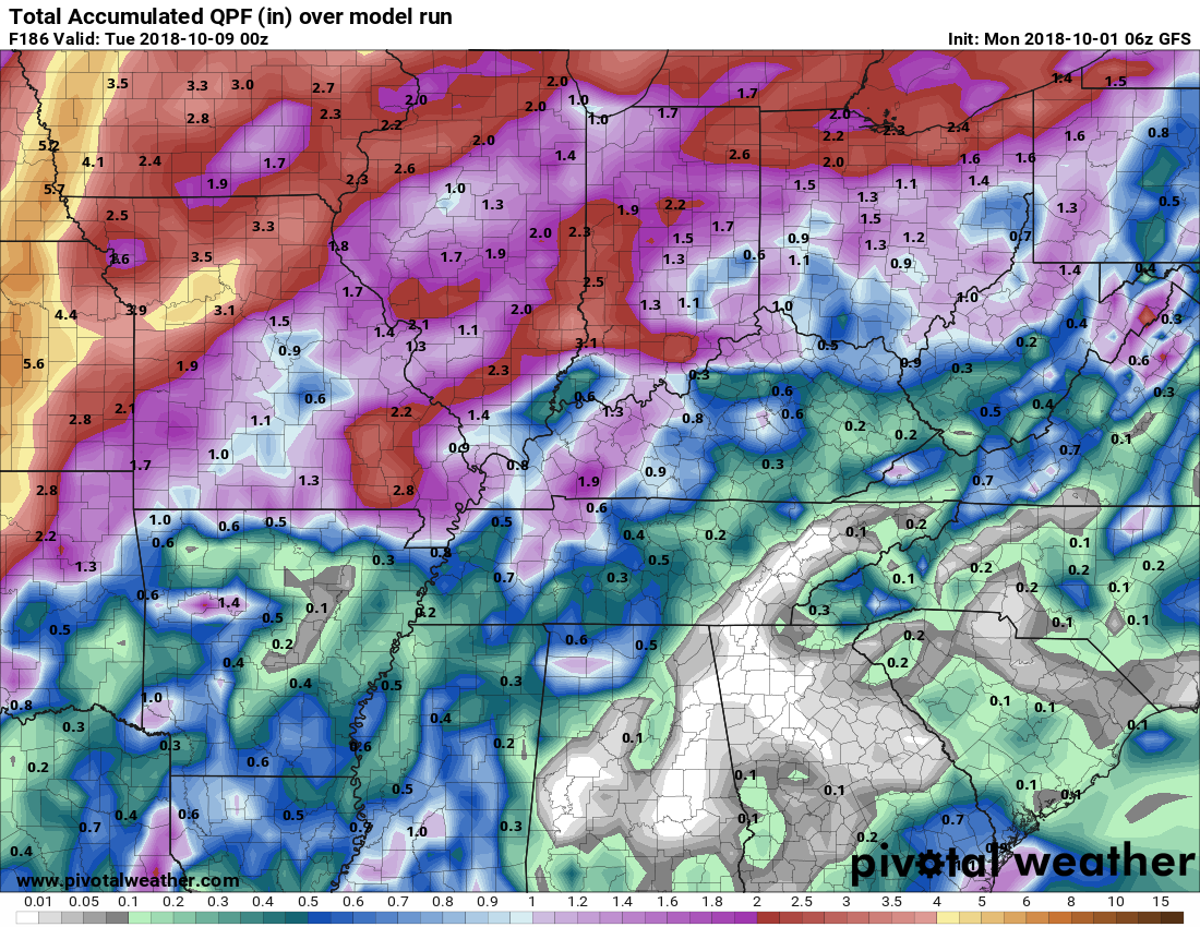
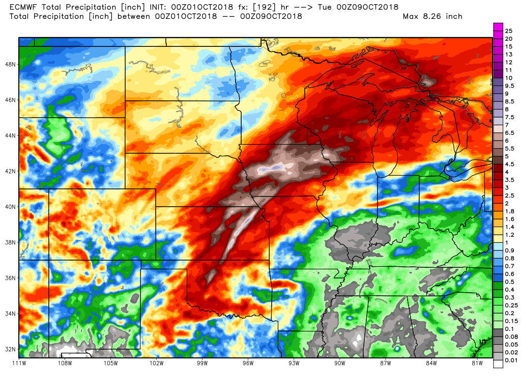
All of the models are showing a heavy band of rain in the Central United States.
Odds favor it running from Texas into Wisconsin.
Here are some examples
The Canadian model
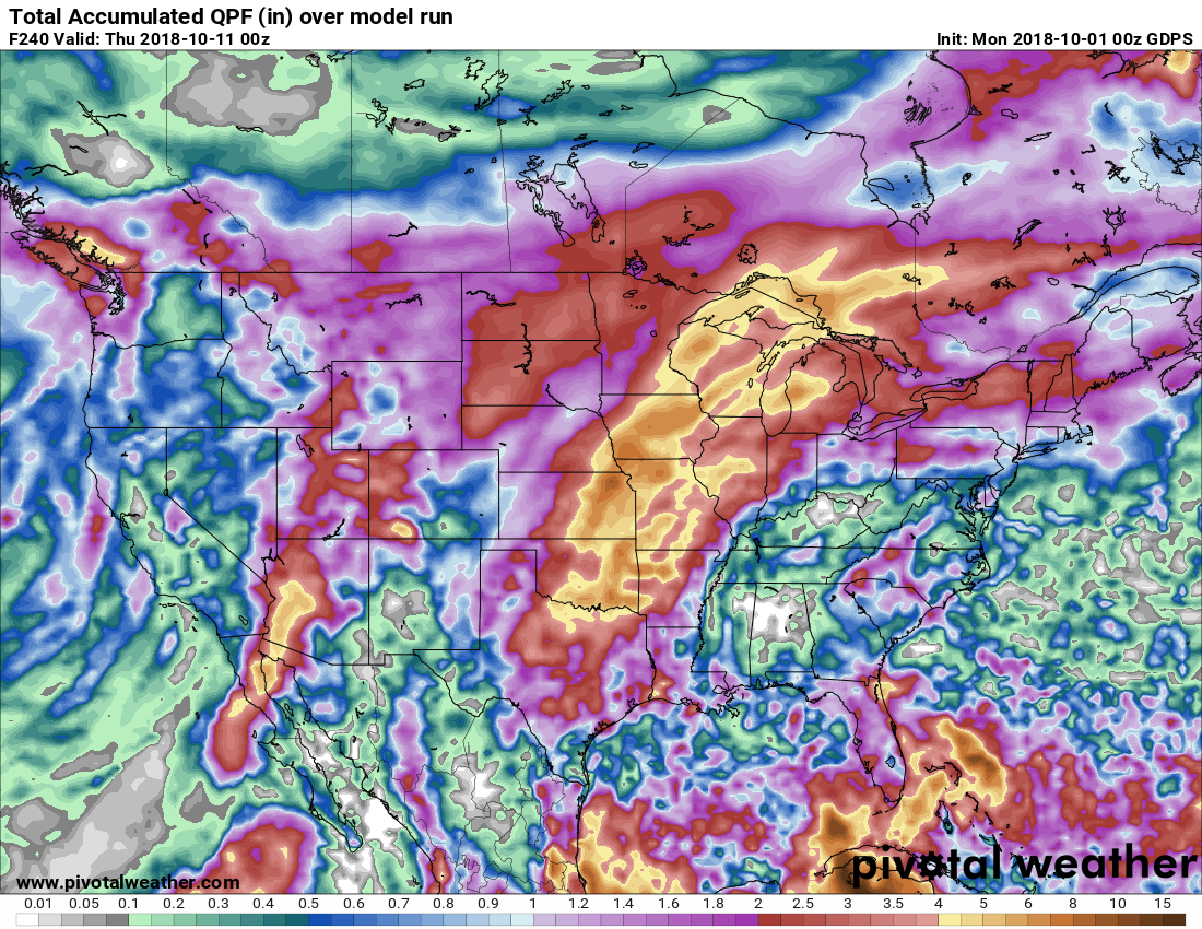
The GFS model
The EC model
Notice that it keeps much of our region dry or mostly dry through Monday evening.
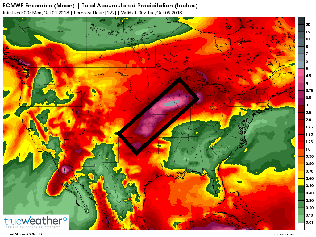
Let’s look at some ensembles.
EC ensemble mean shows the heaviest rain staying to our west and northwest. This is through Monday evening.
Keep in mind, it does show at least some rain in our region. Totals would be on the low side.
GFS ensembles

![]()
Here is the preliminary fall outlook from the long-range meteorology team.
Click to enlarge this graphic.
.
![]()
The September forecast has been updated.
![]()

I bring these to you from the BAMwx team. They are excellent long-range forecasters.
Remember, long-range outlooks are a bit of skill, understanding weather patterns, and luck combined. It is not an exact science.

This product is for subscribers.
Subscribe at www.weathertalk.com
Subscriber graphics can be viewed on this page CLICK HERE

This product is for subscribers.

Subscriber graphics can be viewed on this page CLICK HERE
![]()
.
Fall Outlook!
Preliminary October precipitation outlook
Here is the preliminary November temperature and precipitation outlook
Preliminary November temperature outlook
Preliminary November precipitation outlook
.These products are for subscribers.
![]()

A new weather podcast is now available! Weather Geeks (which you might remember is on The Weather Channel each Sunday)
To learn more visit their website. Click here.
![]()

WeatherBrains Episode 662
Joining us for this episode of WeatherBrains is the Chief Meteorologist at Wichita’s KAKE-TV, and former Birmingham resident Jay Prater. Jay came to KAKE from Panama City, Florida, where he was the morning meteorologist for WJHG-TV. He also worked as the Managing Meteorologist for WSMV-TV in Nashville, Tennessee, and WAFF-TV in Huntsville, Alabama. During his time in Huntsville, he was a weather consultant to the contractor of the Unity Module. Today Unity is in orbit, as a key component of the International Space Station. Jay’s television career began working weekends for WVTM-TV in his native Birmingham, Alabama starting in 1987. Jay, welcome to WeatherBrains!
Other discussions in this weekly podcast include topics like:
- The 1974 Super Outbreak and how it got Jay Prater into weather as a 4th grader
- Bill Murray’s May 2004 storm chasing trip
- The 2007 Greensburg tornado
- How radio plays a role in teaching broadcasting skills, and how the business model has changed over the decades
- Astronomy Outlook with Tony Rice
- and more!
.
Link to their website https://weatherbrains.com/
Previous episodes can be viewed by clicking here.

We offer interactive local city live radars and regional radars. If a radar does not update then try another one. If a radar does not appear to be refreshing then hit Ctrl F5. You may also try restarting your browser.
The local city view radars also have clickable warnings.
During the winter months, you can track snow and ice by clicking the winterize button on the local city view interactive radars.
You may email me at beaudodson@usawx.com
Find me on Facebook!

Find me on Twitter!

Did you know that a portion of your monthly subscription helps support local charity projects?
You can learn more about those projects by visiting the Shadow Angel Foundation website and the Beau Dodson News website.

I encourage subscribers to use the app vs regular text messaging. We have found text messaging to be delayed during severe weather. The app typically will receive the messages instantly. I recommend people have three to four methods of receiving their severe weather information.
Remember, my app and text alerts are hand typed and not computer generated. You are being given personal attention during significant weather events.
