Updated Graphics Sunday, November 11
NAM 3K 18z

WeatherTalk monthly operating costs can top $2000.00. Your $5 subscription helps pay for those costs. I work for you.
The $5 will allow you to register up to seven phones!
For $5 a month you can receive the following. You may choose to receive these via your WeatherTalk app or regular text messaging.
Severe weather app/text alerts from my keyboard to your app/cell phone. These are hand typed messages from me to you. During tornado outbreaks, you will receive numerous app/text messages telling you exactly where the tornado is located.
- Daily forecast app/texts from my computer to your app/cell phone.
- Social media links sent directly to your app/cell phone. When I update the blog, videos, or Facebook you will receive the link.
- AWARE emails. These emails keep you well ahead of the storm. They give you several days of lead time before significant weather events.
- Direct access to Beau via text and email. Your very own personal meteorologist. I work for you!
- Missouri and Ohio Valley centered video updates
- Long-range weather videos
- Week one, two, three and four temperature and precipitation outlooks.
Monthly outlooks. - Your subscription also will help support several local charities.
Would you like to subscribe? Subscribe at www.beaudodsonweather.com
Typical progression on a severe weather day for subscribers.


I encourage subscribers to use the app vs regular text messaging. We have found text messaging to be delayed during severe weather. The app typically will receive the messages instantly. I recommend people have three to four methods of receiving their severe weather information.
Remember, my app and text alerts are hand typed and not computer generated. You are being given my personal attention during significant weather events.

WWW.WEATHERTALK.COM subscribers, here is my day to day schedule for your weather products.
These are bonus videos and maps for subscribers. I bring these to you from the BAMwx team. I pay them to help with videos.
The Ohio and Missouri Valley videos cover most of our area. They do not have a specific Tennessee Valley forecast but may add one in the future.
The long-range video is technical. Over time, you can learn a lot about meteorology from the long range video. Just keep in mind, it is a bit more technical.


.
![]()

This forecast was updated at 8 AM on Wednesday, November 5, 2018
November 9, 2018
Friday forecast: Morning clouds giving way to a mix of sun and clouds. Any remaining showers will end. Cold. Well below normal temperatures.
Temperatures: MO ~ 43 to 46 IL ~ 43 to 46 KY ~ 44 to 48 TN ~ 45 to 50
What is the chance of precipitation? MO ~ 20% IL ~ 30% KY ~ 30% TN ~ 20%
Coverage of precipitation: Ending
Is snow or ice anticipated? Most likely no
Wind: North and northwest at 6 to 12 mph with gusts to 20 mph
What impacts are anticipated from the weather? A few morning wet roadways.
My confidence in the forecast verifying: High
Is severe weather expected? No
The NWS defines severe weather as 58 mph wind or great, 1″ hail or larger, and/or tornadoes
Should I cancel my outdoor plans? No
UV Index: 4 to 6 Moderate
Sunrise: 6:28 AM
Friday Night Forecast Details:
Forecast: Increasing clouds. A chance of snow showers. Gusty winds, as well. Cold. Wind chills in the middle to upper teens.
Temperatures: MO ~ 18 to 24 IL ~ 20 to 24 KY ~ 20 to 25 TN ~ 23 to 26
What is the chance of precipitation? MO ~ 40% IL ~ 40% KY ~ 30% TN ~ 30%
Coverage of precipitation: Scattered
Frost Risk: A hard freeze likely
Is snow or ice anticipated? Snow showers are possible. A dusting of snow will be possible over the northern half of southeast Missouri, then across southern Illinois, and into northwest Kentucky. Many areas won’t see accumulation but a few spots may.
Wind: Northwest at 5 to 10 mph with gusts to 20 mph
What impacts are anticipated from the weather? Hard freeze. Snow showers could make bridges icy.
My confidence in the forecast verifying: Medium
Is severe weather expected? No
The NWS defines severe weather as 58 mph wind or great, 1″ hail or larger, and/or tornadoes
Should I cancel my outdoor plans? No, but monitor snow showers on radar
Sunset: 4:49 PM
Moonrise: 8:16 AM Waxing Crescent
Moonset: 6:36 PM
November 10, 2018
Saturday forecast: Mostly sunny and cold with well below normal temperatures. These highs are colder than normal January highs.
Temperatures: MO ~ 35 to 40 IL ~ 35 to 40 KY ~ 36 to 42 TN ~ 38 to 44
What is the chance of precipitation? MO ~ 0% IL ~ 0% KY ~ 0% TN ~ 0%
Coverage of precipitation: None
Is snow or ice anticipated? No
Wind: North at 6 to 12 mph. Winds becoming variable through the day.
What impacts are anticipated from the weather? None
My confidence in the forecast verifying: High
Is severe weather expected? No
The NWS defines severe weather as 58 mph wind or great, 1″ hail or larger, and/or tornadoes
Should I cancel my outdoor plans? No
UV Index: 3 to 4 Moderate
Sunrise: 6:29 AM
Saturday Night Forecast Details:
Forecast: Mostly clear. Cold. A hard freeze. Well below normal temperatures.
Temperatures: MO ~ 23 to 26 IL ~ 23 to 26 KY ~ 23 to 26 TN ~ 23 to 26
What is the chance of precipitation? MO ~ 0% IL ~ 0% KY ~ 0% TN ~ 0%
Coverage of precipitation: None
Frost Risk: Another hard freeze
Is snow or ice anticipated? No
Wind: Becoming southeast at 5 to 10 mph
What impacts are anticipated from the weather? Hard freeze.
My confidence in the forecast verifying: High
Is severe weather expected? No
The NWS defines severe weather as 58 mph wind or great, 1″ hail or larger, and/or tornadoes
Should I cancel my outdoor plans? No
Sunset: 4:48 PM
Moonrise: 9:15 AM Waxing Crescent
Moonset: 7:21 PM
November 11, 2018
Sunday forecast: A mix of sun and clouds. Chilly. Well below normal temperatures.
Temperatures: MO ~ 44 to 48 IL ~ 44 to 48 KY ~ 46 to 50 TN ~ 46 to 52
What is the chance of precipitation? MO ~ 0% IL ~ 0% KY ~ 0% TN ~ 0%
Coverage of precipitation: None
Is snow or ice anticipated? No
Wind: South and southeast at 5 to 10 mph
What impacts are anticipated from the weather? None
My confidence in the forecast verifying: Medium
Is severe weather expected? No
The NWS defines severe weather as 58 mph wind or great, 1″ hail or larger, and/or tornadoes
Should I cancel my outdoor plans? No
UV Index: 3 to 4 Moderate
Sunrise: 6:30 AM
Sunday Night Forecast Details:
Forecast: Partly cloudy to cloudy. A slight chance of snow flurries. Cold. Below normal temperatures.
Temperatures: MO ~ 28 to 34 IL ~ 28 to 34 KY ~ 32 to 36 TN ~ 32 to 36
What is the chance of precipitation? MO ~ 20% IL ~ 20% KY ~ 20% TN ~ 20%
Coverage of precipitation: Isolated
Frost Risk: A freeze again possible
Is snow or ice anticipated? Flurries with no impact.
Wind: Northeast at 3 to 6 mph
What impacts are anticipated from the weather? Most likely no.
My confidence in the forecast verifying: Medium.
Is severe weather expected? No
The NWS defines severe weather as 58 mph wind or great, 1″ hail or larger, and/or tornadoes
Should I cancel my outdoor plans? No
Sunset: 4:47 PM
Moonrise: 10:09 AM Waxing Crescent
Moonset: 8:08 PM
November 12, 2018
Monday forecast: Increasing clouds. Cold. Snow or rain showers possible.
Temperatures: MO ~ 44 to 48 IL ~ 45 to 50 KY ~ 48 to 52 TN ~ 48 to 52
What is the chance of precipitation? MO ~ 20% IL ~ 20% KY ~ 40% TN ~ 40%
Coverage of precipitation: Scattered to perhaps numerous. Greater coverage from west Tennessee into western Kentucky. The further south and east you travel the greater the chance of precipitation.
Is snow or ice anticipated? Most likely not during the day.
Wind: North at 7 to 14 mph
What impacts are anticipated from the weather? Wet roadways.
My confidence in the forecast verifying: LOW
Is severe weather expected? No
The NWS defines severe weather as 58 mph wind or great, 1″ hail or larger, and/or tornadoes
Should I cancel my outdoor plans? No, but monitor updates and radars.
UV Index: 2 to 4 Low to moderate
Sunrise: 6:31 AM
Monday Night Forecast Details:
Forecast: Mostly cloudy. A chance of snow. Well below normal temperatures.
Temperatures: MO ~ 24 to 28 IL ~ 24 to 28 KY ~ 24 to 28 TN ~ 24 to 28
What is the chance of precipitation? MO ~ 30% IL ~ 30% KY ~ 50% TN ~ 50%
Coverage of precipitation: Scattered to perhaps numerous.
Frost Risk: No
Is snow or ice anticipated? Yes. Some snow is in the forecast.
Wind: North and northwest at 7 to 14 mph and gusty
What impacts are anticipated from the weather? Wet roadways. We will need to monitor the roads. Icy bridges and/or roads can’t be ruled out. There remain questions about the extent of the precipitation.
My confidence in the forecast verifying: LOW
Is severe weather expected? No
The NWS defines severe weather as 58 mph wind or great, 1″ hail or larger, and/or tornadoes
Should I cancel my outdoor plans? Have a plan B and monitor the latest forecast updates.
Sunset: 4:47 PM
Moonrise: 10:58 AM Waxing Crescent
Moonset: 9:09 PM
November 13, 2018
Tuesday forecast: Morning clouds. Snow showers possible before 12 PM. Clearing through the day. Colder. Well below normal temperatures.
Temperatures: MO ~ 32 to 36 IL ~ 34 to 36 KY ~ 34 to 38 TN ~ 35 to 40
What is the chance of precipitation? MO ~ 20% IL ~ 20% KY ~ 30% TN ~ 30%
Coverage of precipitation: Ending
Is snow or ice anticipated? Possible early
Wind: Northeast at 10 to 20 mph and gusty
What impacts are anticipated from the weather? Slick roads can’t be ruled out. This will depend on storm track and extent of precipitation.
My confidence in the forecast verifying: Medium
Is severe weather expected? No
The NWS defines severe weather as 58 mph wind or great, 1″ hail or larger, and/or tornadoes
Should I cancel my outdoor plans? Monitor updates.
UV Index: 3 to 5 Moderate
Sunrise: 6:32 AM
Tuesday Night Forecast Details:
Forecast: Clearing and cold. Well below normal temperatures.
Temperatures: MO ~ 20 to 25 IL ~ 22 to 25 KY ~ 23 to 26 TN ~ 23 to 26
What is the chance of precipitation? MO ~ 0% IL ~ 0% KY ~ 0% TN ~ 0%
Coverage of precipitation: None
Frost Risk: Hard freeze
Is snow or ice anticipated? No
Wind: Northwest at 6 to 12 mph
What impacts are anticipated from the weather? None
My confidence in the forecast verifying: Medium
Is severe weather expected? No
The NWS defines severe weather as 58 mph wind or great, 1″ hail or larger, and/or tornadoes
Should I cancel my outdoor plans? No
Sunset: 4:46 PM
Moonrise: 11:43 AM Waxing Crescent
Moonset: 9:53 PM
November 14, 2018
Wednesday forecast: Mostly sunny. Cold. Well below normal temperatures to continue.
Temperatures: MO ~ 38 to 44 IL ~ 38 to 44 KY ~ 38 to 44 TN ~ 38 to 44
What is the chance of precipitation? MO ~ 0% IL ~ 0% KY ~ 0% TN ~ 0%
Coverage of precipitation: None
Is snow or ice anticipated? No
Wind:
What impacts are anticipated from the weather? None
My confidence in the forecast verifying: Medium
Is severe weather expected? No
The NWS defines severe weather as 58 mph wind or great, 1″ hail or larger, and/or tornadoes
Should I cancel my outdoor plans? No
UV Index: 3 to 5 Moderate
Sunrise: 6:33 AM
Wednesday Night Forecast Details:
Forecast: Mostly clear. Chilly.
Temperatures: MO ~ 24 to 28 IL ~ 24 to 28 KY ~ 24 to 28 TN ~ 24 to 28
What is the chance of precipitation? MO ~ 0% IL ~ 0% KY ~ 0% TN ~ 0%
Coverage of precipitation: None
Frost Risk: Hard freeze
Is snow or ice anticipated? No
Wind:
What impacts are anticipated from the weather? None
My confidence in the forecast verifying: Medium
Is severe weather expected? No
The NWS defines severe weather as 58 mph wind or great, 1″ hail or larger, and/or tornadoes
Should I cancel my outdoor plans? No
Sunset: 4:45 PM
Moonrise: 12:22 AM Waxing Crescent
Moonset: 10:48 PM
November 15, 2018
Thursday forecast: Mostly sunny. Not quite as cold. Well below normal temperatures to continue.
Temperatures: MO ~ 45 to 50 IL ~ 45 to 50 KY ~ 45 to 50 TN ~ 45 to 50
What is the chance of precipitation? MO ~ 0% IL ~ 0% KY ~ 0% TN ~ 0%
Coverage of precipitation: None
Is snow or ice anticipated? No
Wind:
What impacts are anticipated from the weather? None
My confidence in the forecast verifying: Medium
Is severe weather expected? No
The NWS defines severe weather as 58 mph wind or great, 1″ hail or larger, and/or tornadoes
Should I cancel my outdoor plans? No
UV Index: 3 to 5 Moderate
Sunrise: 6:34 AM
Thursday Night Forecast Details:
Forecast: Mostly clear.
Temperatures: MO ~ 28 to 34 IL ~ 28 to 34 KY ~ 28 to 34 TN ~ 28 to 34
What is the chance of precipitation? MO ~ 0% IL ~ 0% KY ~ 0% TN ~ 0%
Coverage of precipitation: None
Is snow or ice anticipated? No
Wind:
What impacts are anticipated from the weather? None
My confidence in the forecast verifying: Medium
Is severe weather expected? No
The NWS defines severe weather as 58 mph wind or great, 1″ hail or larger, and/or tornadoes
Should I cancel my outdoor plans? No
Sunset: 4:44 PM
Moonrise: 12:57 PM First Quarter
Moonset: 11:43 PM
November 16, 2018
Friday forecast: Mostly sunny. Not quite as cold.
Temperatures: MO ~ 48 to 54 IL ~ 50 to 52 KY ~ 50 to 54 TN ~ 50 to 54
What is the chance of precipitation? MO ~ 0% IL ~ 0% KY ~ 0% TN ~ 0%
Coverage of precipitation: None
Is snow or ice anticipated? No
Wind:
What impacts are anticipated from the weather? None
My confidence in the forecast verifying: Medium
Is severe weather expected? No
The NWS defines severe weather as 58 mph wind or great, 1″ hail or larger, and/or tornadoes
Should I cancel my outdoor plans? No
UV Index: 3 to 5 Moderate
Sunrise: 6:34 AM
Friday Night Forecast Details:
Forecast: Mostly clear.
Temperatures: MO ~ 28 to 34 IL ~ 28 to 34 KY ~ 28 to 34 TN ~ 28 to 34
What is the chance of precipitation? MO ~ 0% IL ~ 0% KY ~ 0% TN ~ 0%
Coverage of precipitation: None
Is snow or ice anticipated? No
Wind:
What impacts are anticipated from the weather? None
My confidence in the forecast verifying: Medium
Is severe weather expected? No
The NWS defines severe weather as 58 mph wind or great, 1″ hail or larger, and/or tornadoes
Should I cancel my outdoor plans? No
Sunset: 4:44 PM
Moonrise: 12:57 PM First Quarter
Moonset: 11:43 PM
November 17, 2018
Saturday forecast: Partly sunny. Chilly.
Temperatures: MO ~ 46 to 52 IL ~ 46 to 52 KY ~ 48 to 54 TN ~ 50 to 54
What is the chance of precipitation? MO ~ 0% IL ~ 0% KY ~ 0% TN ~ 0%
Coverage of precipitation: None
Is snow or ice anticipated? No
Wind:
What impacts are anticipated from the weather? None
My confidence in the forecast verifying: Medium
Is severe weather expected? No
The NWS defines severe weather as 58 mph wind or great, 1″ hail or larger, and/or tornadoes
Should I cancel my outdoor plans? No
UV Index: 3 to 5 Moderate
Sunrise: 6:35 AM
Saturday Night Forecast Details:
Forecast: Mostly clear. Cold.
Temperatures: MO ~ 28 to 34 IL ~ 28 to 34 KY ~ 28 to 34 TN ~ 28 to 34
What is the chance of precipitation? MO ~ 0% IL ~ 0% KY ~ 0% TN ~ 0%
Coverage of precipitation: None
Is snow or ice anticipated? No
Wind:
What impacts are anticipated from the weather? None
My confidence in the forecast verifying: Medium
Is severe weather expected? No
The NWS defines severe weather as 58 mph wind or great, 1″ hail or larger, and/or tornadoes
Should I cancel my outdoor plans? No
Sunset: 4:44 PM
Moonrise: 1:30 PM Waxing Gibbous
Moonset: 12:01 AM

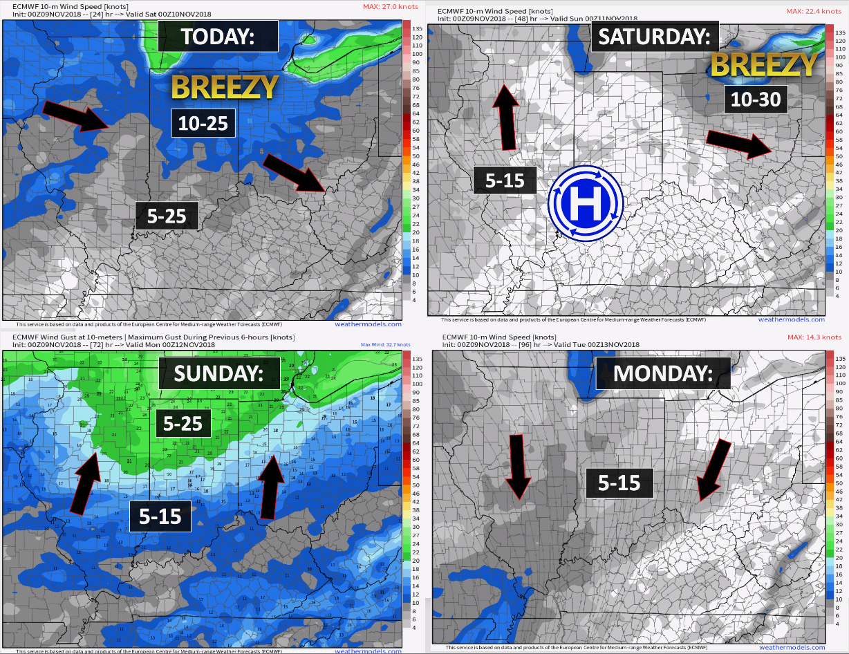
Today through Sunday: Snow showers are likely this evening. This is most likely across the northern half of southeast Missouri and then across southern Illinois into northwest Kentucky. Some of the snow showers could dust surfaces and bridges. Use care if this does develop. Gusty winds will help produce wind chills into the teens.
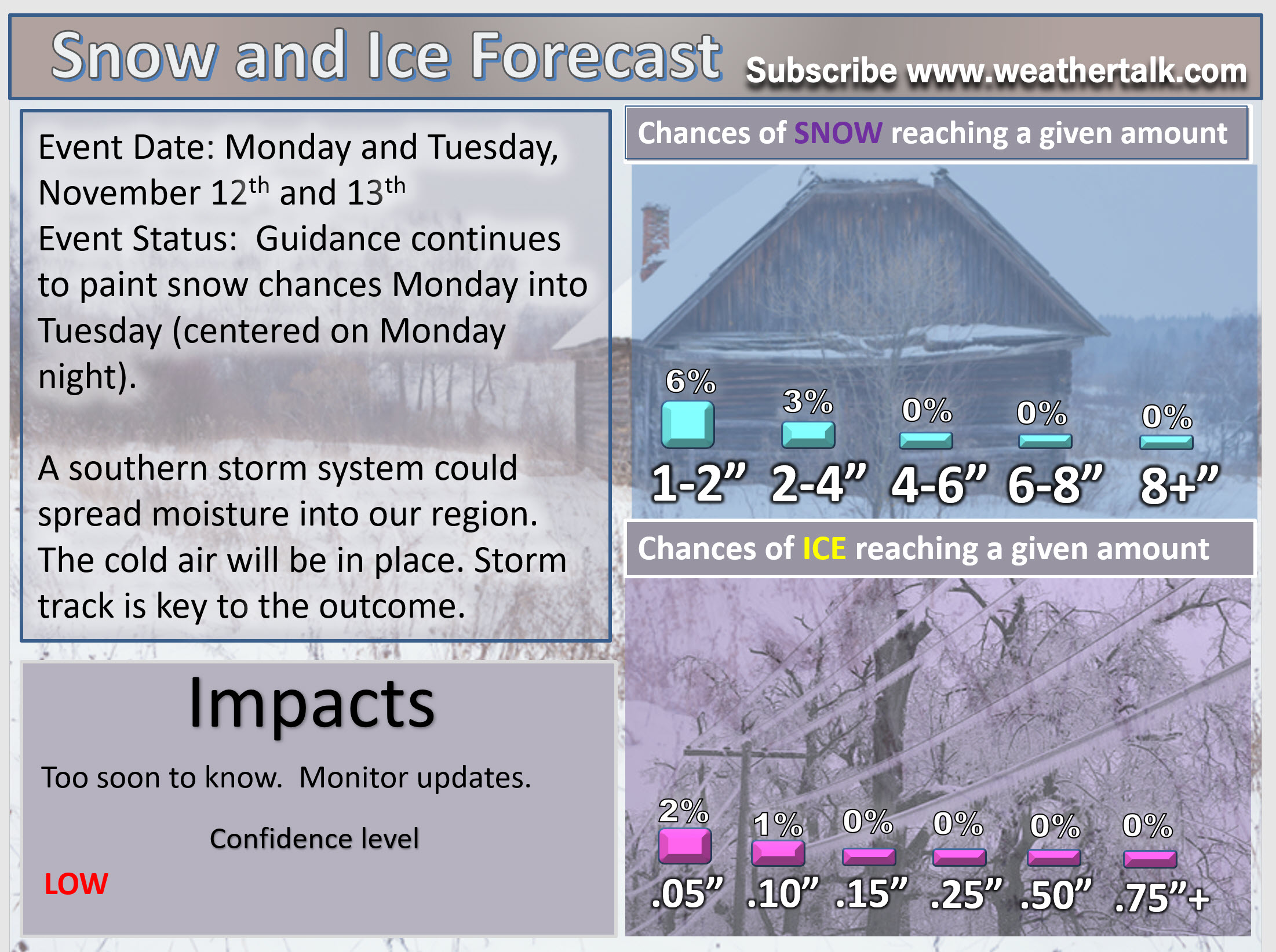
Sunday night into Tuesday night: Monitor updates. I am watching a potential winter weather event Monday afternoon into Tuesday. It is still too early to know whether or not our region will be impacted. Scroll down further in this update to see some graphics.
We still have a number of days to go before this event gains confidence levels one way or another (meaning snow or no snow).
As always, winter weather events are tricky, at best. It would be early in the season if this event does occur.
Wind forecast
The Weather Observatory will be holding two open houses for adults and children. Weather permitting, the open house will be Saturday, December 1st.
Class of 1988 (Massac County High School). I will be having a special open house for you on Friday, November 30th (the night before the other open house)

Learn more about the UV index readings. Click here.

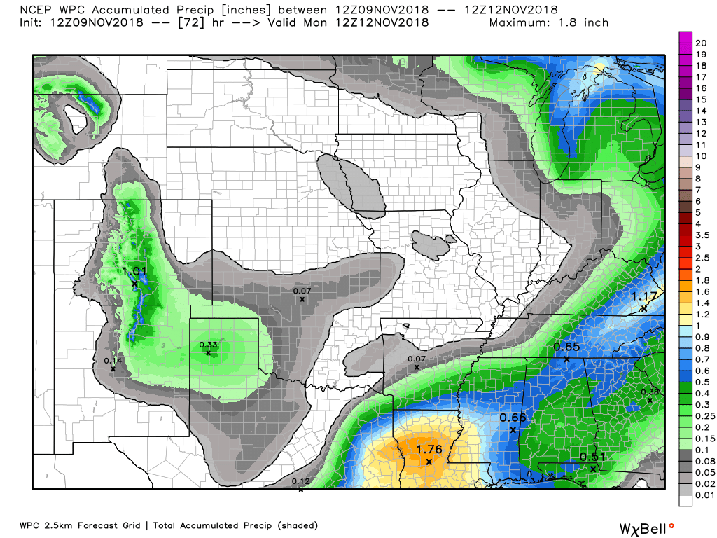
Here is the WPC/NOAA rainfall outlook
A few light showers remain over our eastern counties this morning. That rain will depart.
Here is the WPC rainfall outlook through Monday morning.
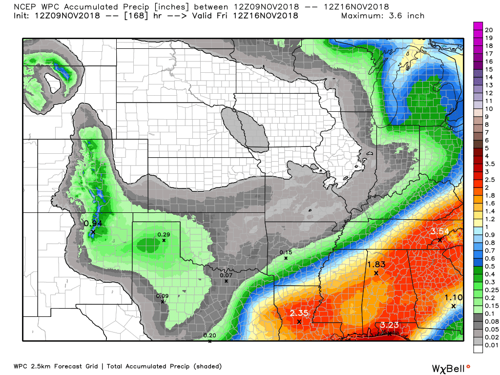
Let’s look at totals through next Friday.
The next best chance of precipitation will be Monday into Tuesday. Low confidence in the eventual outcome of that system.
Notice the large totals to our south and east. That gives you an idea on storm track. There remain numerous questions about that event. Monitor updates.

Subscribers, do you need a forecast for an outdoor event?


We offer interactive local city live radars and regional radars.
If a radar does not update then try another one. If a radar does not appear to be refreshing then hit Ctrl F5 on your keyboard.
You may also try restarting your browser. The local city view radars also have clickable warnings.
During the winter months, you can track snow and ice by clicking the winterize button on the local city view interactive radars.

Questions? Broken links? Other questions?
You may email me at beaudodson@usawx.com

The National Weather Service defines a severe thunderstorm as one that produces quarter size hail or larger, 58 mph winds or greater, and/or a tornado.
Today through next Friday: No severe storms.
Interactive live weather radar page. Choose the city nearest your location. If one of the cities does not work then try a nearby one. Click here.
National map of weather watches and warnings. Click here.
Storm Prediction Center. Click here.
Weather Prediction Center. Click here.

Live lightning data: Click here.

Interactive GOES R satellite. Track clouds. Click here.

Here are the latest local river stage forecast numbers Click Here.
Here are the latest lake stage forecast numbers for Kentucky Lake and Lake Barkley Click Here.

- Any remaining showers ending
- Snow showers tonight. Dusting in spots (MO/IL mainly)
- Cold
- Hard freeze.
- I continue to monitor snow chances early next week
Update:
I have increased snow chances this evening into tonight. An upper-level disturbance is diving into the region from the northwest. This will spread scattered snow showers into southeast Missouri (northern counties) and then across southern Illinois. The snow showers should survive into western Kentucky, as well.
Most areas will not see accumulating, however, I can’t rule out a dusting or so in spots. With temperatures falling into the 20’s this could cause icy bridges. Use care.
Wind chills tonight will drop into the teens.
It is a chilly morning across our region. Many of you received light rain overnight. There were some wet snowflakes/sleet pellets reported, as well. No impacts, because temperatures were too warm.
Rain totals ranged from 0.00″ to 0.30″. The higher totals were along the KY/TN border towards Murray/LBL and then eastward.
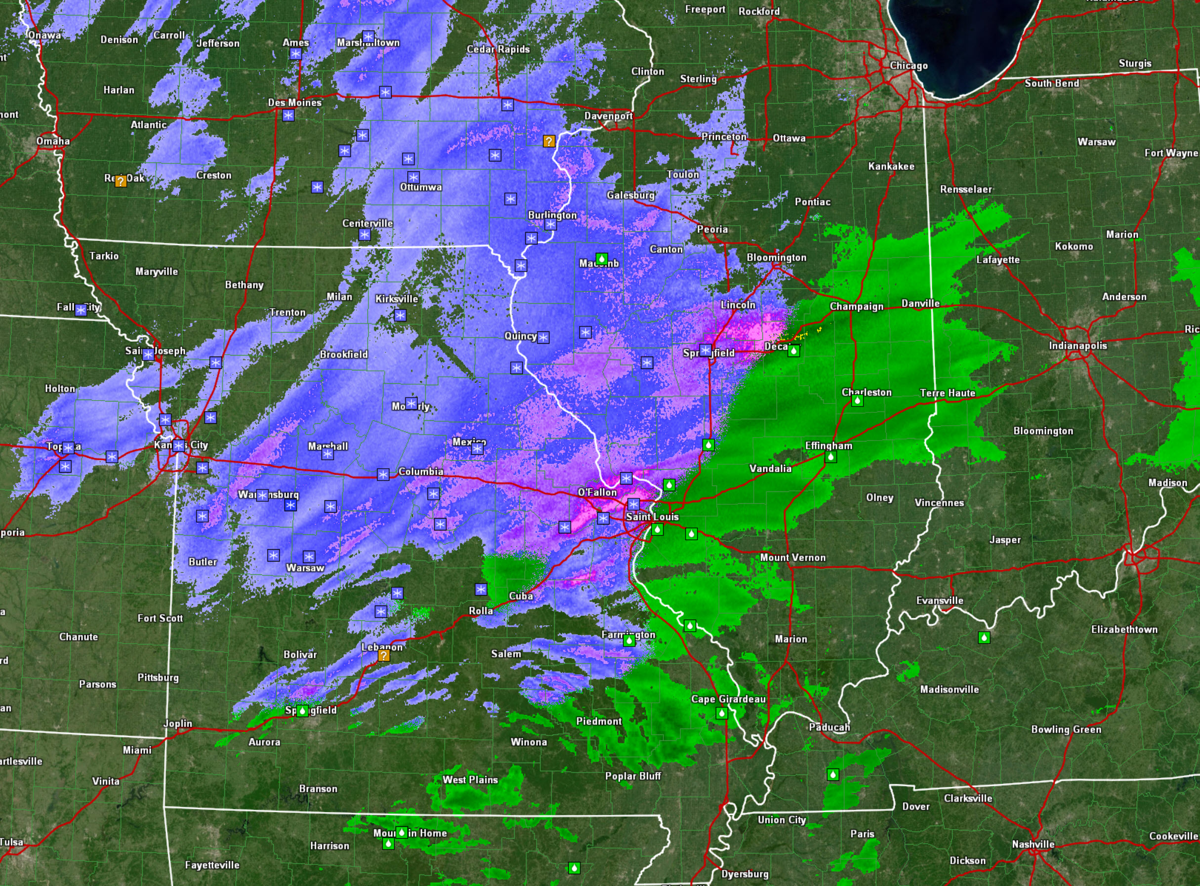
Here was the radar last night around 9 PM. The blue and pink colors represent snow. There were numerous reports of snow across the northern half of Missouri. There were even some reports of a heavy dusting to an inch or so.
Not too early for snow.
Green represented rain.
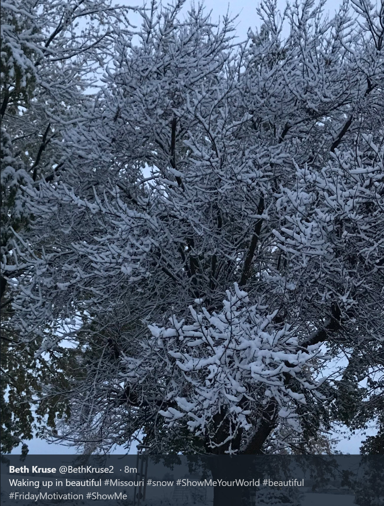
Here are some snow photos from Missouri. These are from the last few hours.


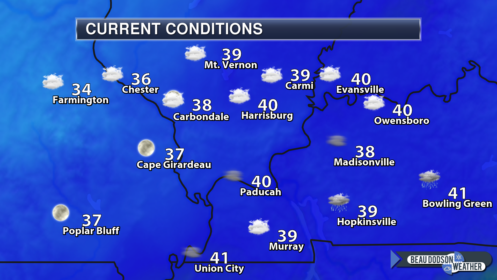
6 AM temperatures were mostly in the upper 30’s to lower 40’s. A few counties in southeast Missouri were colder.
The big weather story, over the coming days, continues to be the winter-like temperatures.
January high temperatures are normally in the 40’s with lows in the 20’s. We will be hitting those marks in the coming days. It will not feel like November.
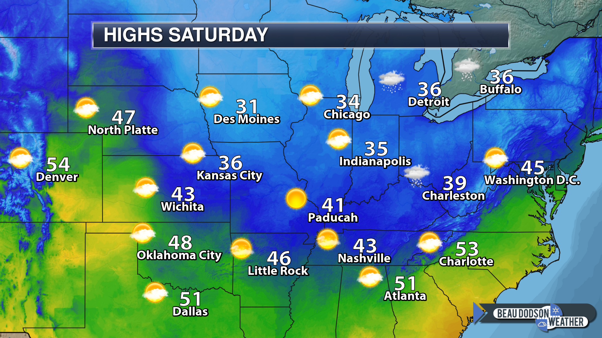
Highs today
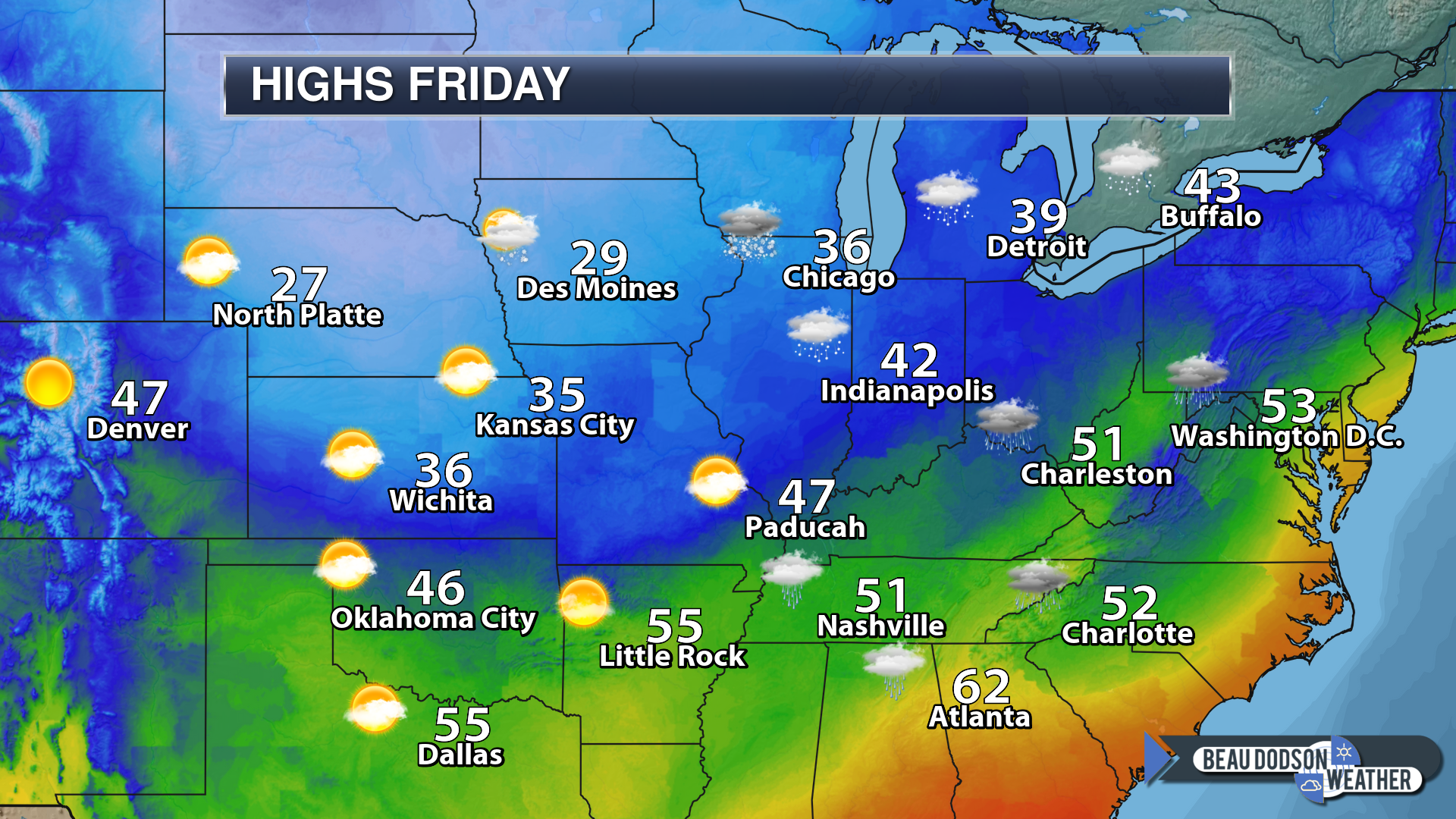
Highs on Friday
Lows on Friday night
A hard freeze tonight.
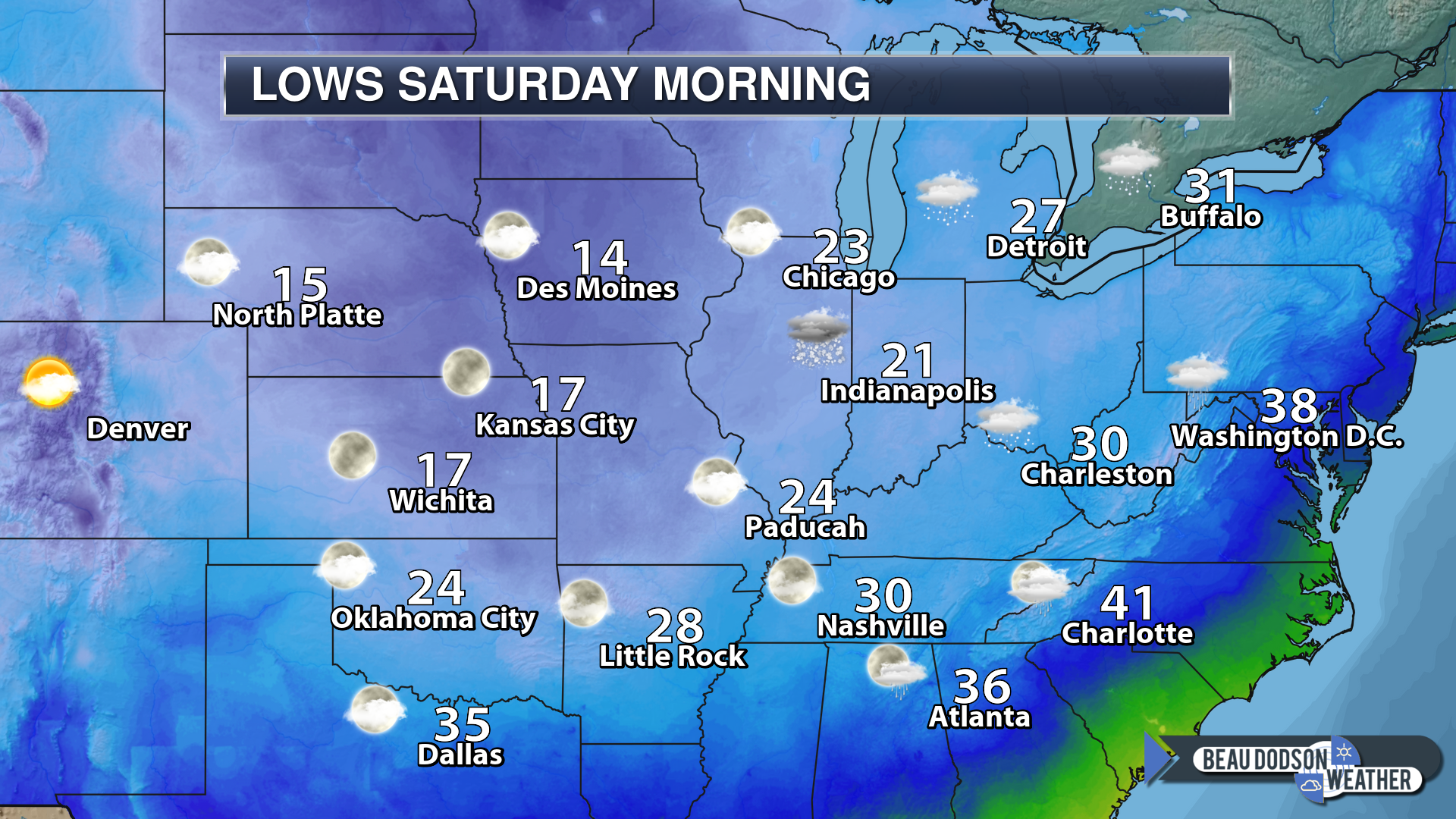
Lows Saturday night
Highs Sunday
Another hard freeze Saturday night.

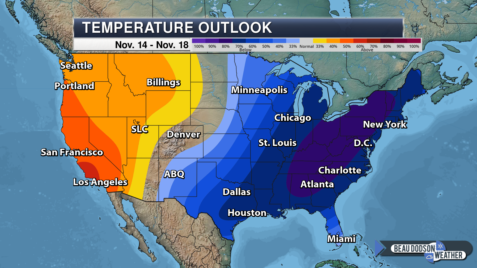
NOAA’s November 14th through November 18th temperature outlook is a cold one for the eastern United States.
You will notice that the cold is slowly shifting eastward with time. Yesterday’s outlook was showing our region in the center of the cold. Now, it starts to shift east. That could be a signal of a moderating trend as we move towards the middle/end of November. This will begin as early as next Thursday.
This graphic does not tell you actual temperatures. It tells you the chances of temperatures being above or below normal. High chance of below normal temperatures.
Saturday and Sunday
Saturday and Sunday will be dry. It will be cold. WELL below normal temperatures. As a matter of fact, high temperatures on Saturday may remain in the 30’s for many of us. These are COLD temperatures for this early in the season (esp without snow on the ground).
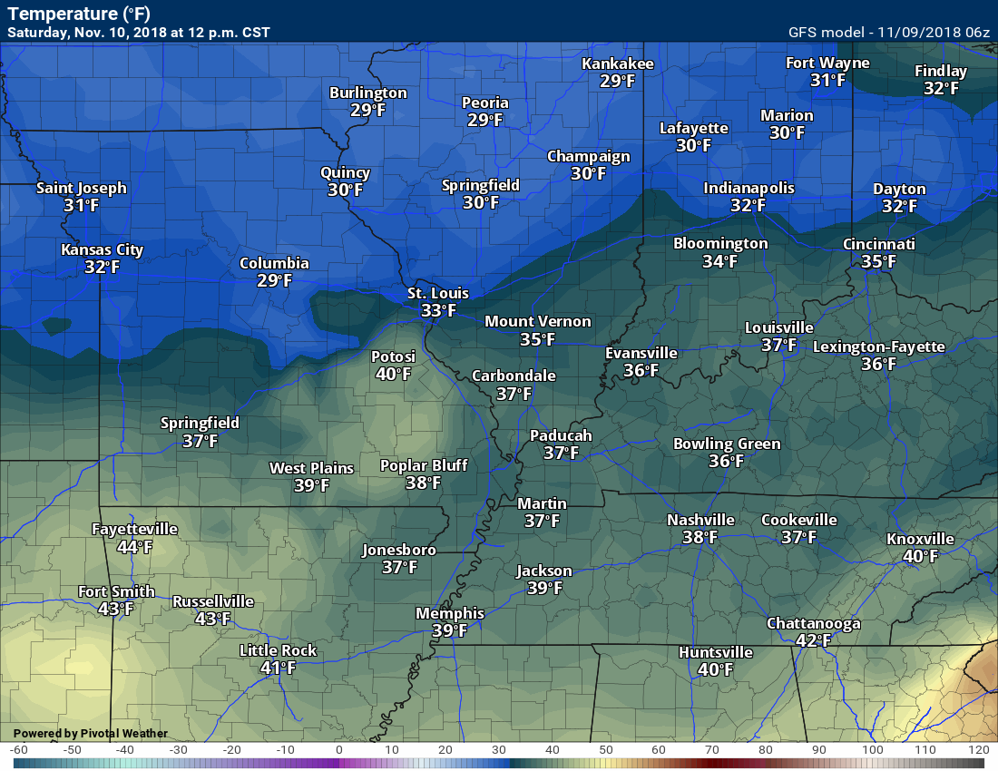
Here is what the GFS model is forecasting for high temperatures Saturday afternoon. It may be a few degrees warmer (using that word loosely) than this.
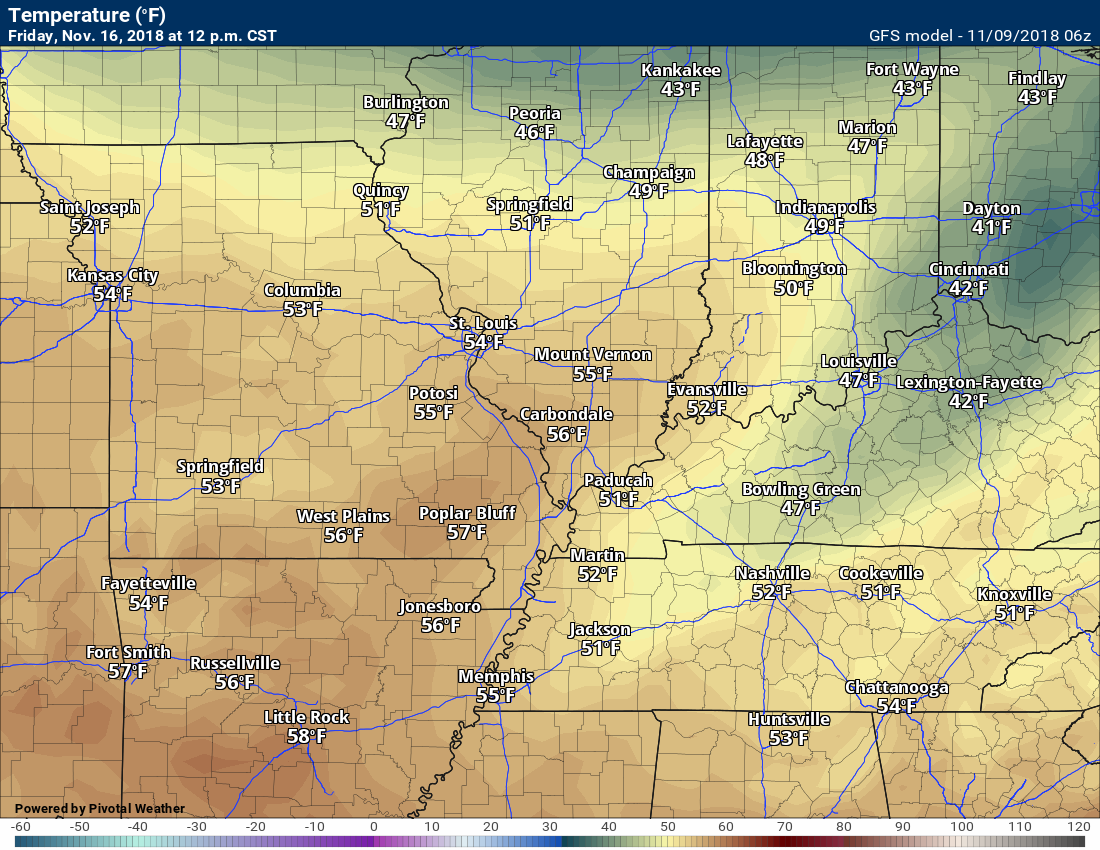
Keep hope alive (those who don’t like cold air). Here is the GFS forecast for next Friday. We will see how that goes.
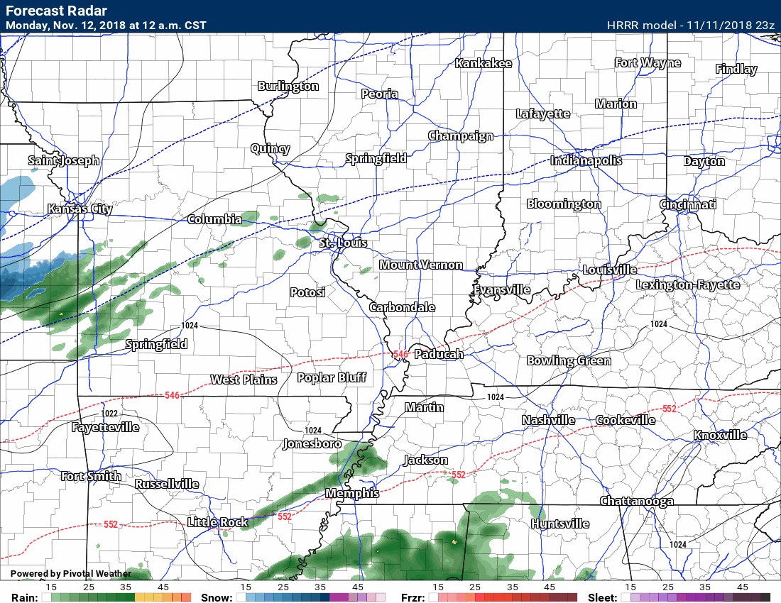
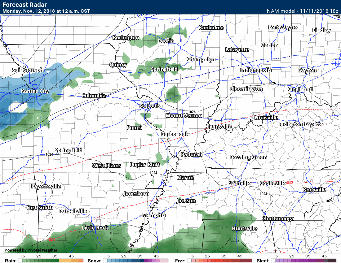
Precipitation event early next week.
I continue to monitor Monday and Tuesday for rain and snow.
Some precipitation appears possible Monday afternoon into Tuesday. The brunt of this system is forecast to drop moderate to heavy precipitation across the Gulf of Mexico into portions of the Tennessee Valley and then north and east from there.
These Gulf of Mexico systems tend to be prolific precipitation producers. No lack of moisture. That doesn’t, however, mean our region will be on the receiving end of the heavier rain/snow.
The model guidance has been consistently showing some type of snow event in or near our region.
The problem is in the details. As always, this is the case locally.
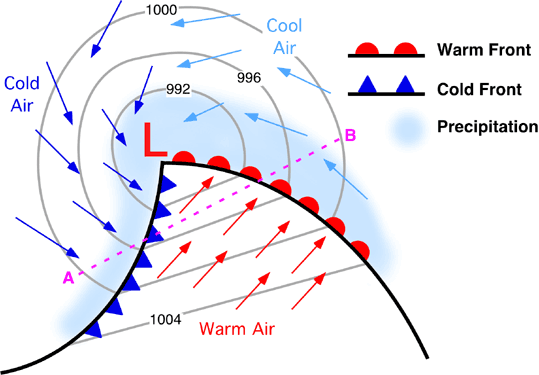
The track of the area of low pressure (and strength) will determine how far northwest precipitation will occur.
Low pressure rotates counter-clockwise. If you want snow, during the winter months, then you want to be on the northern side of the area of low pressure.
Here is an example of an area of low pressure.
The problem is that any shift in the track will change the forecast. Well, that is impossible to forecast days in advance.
We can forecast generalities. We can forecast patterns. We can’t forecast specifics (days in advance).
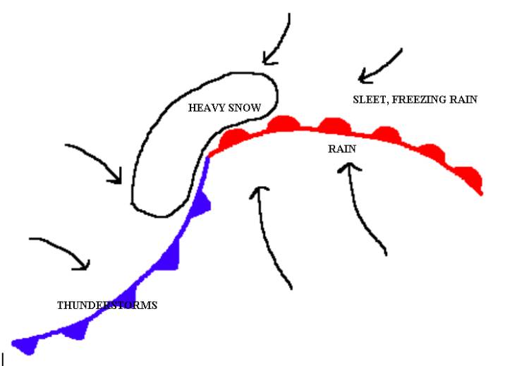
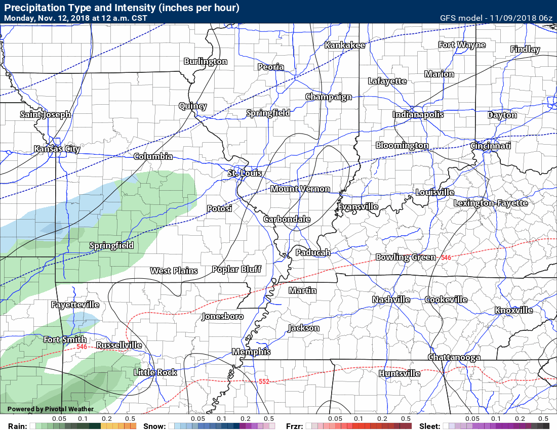
Some models show a band of snow to our north and west.
More often than not, however, the model guidance shows the heaviest precipitation totals to our south and east.
It will be an uphill battle to receive accumulating snow locally. Is it impossible? Absolutely not. The question remains probabilities.
As always, forecasting snow locally is tricky. Storm track, air temperatures, ground temperatures, road temperatures, and other factors have to be considered.
I like to use ensembles when considering a forecast.
Ensembles are bullish on the idea of precipitation Monday and Tuesday. The type of precipitation varies in the ensemble data.
In theory, ensembles give you a better feel for what might happen.
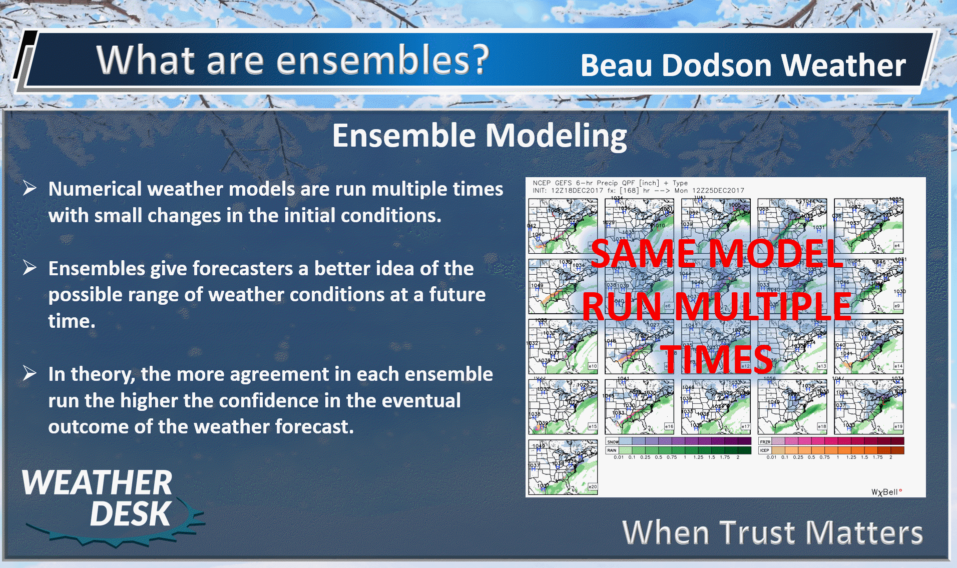
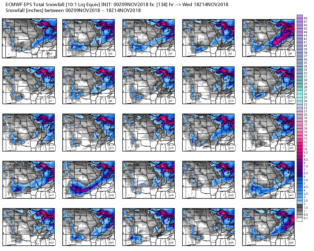
This next graphic is the GFS ensembles.
There are two main model sets. The GFS and the EC (there are more, but these are the two main ones).
Here are the GFS ensembles.
Remember, the more squares that agree, the greater the confidence in the eventual outcome.
If every square was showing one to three inches of snow in our region, then my confidence in forecasting snow would increase.
Many of the squares show some snow locally. Keep in mind, the frames that show light amounts are numerous, but much of that would probably not stick.
It would take a heavier precipitation event to cause the snow to overcome the obstacles. Obstacles would mean ground temperatures, road temperatures, air temperatures, and so on. Could it happen? Yes. Questions, however, remain on the likelihood.
What does this mean?
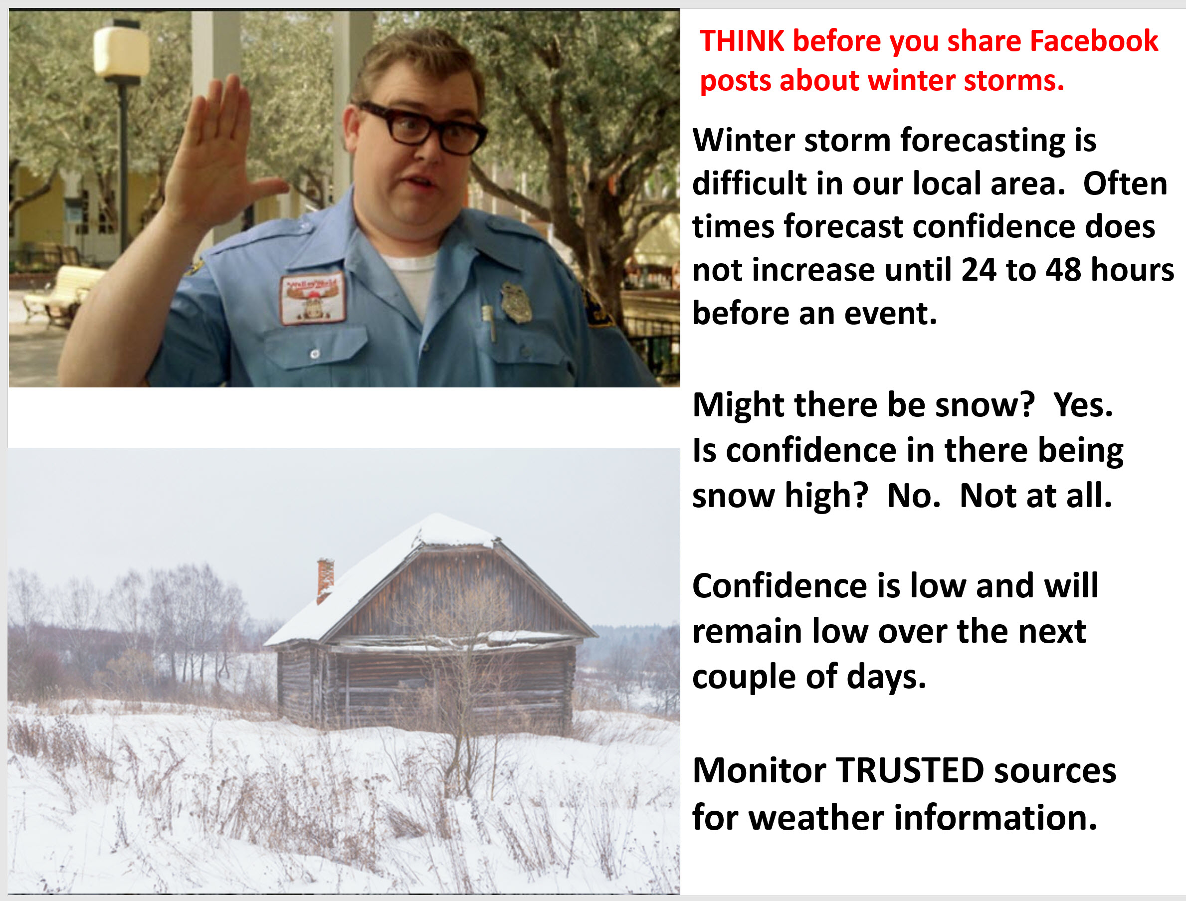
At this point, not much. It is something I continue to monitor. Typically, winter weather events remain uncertain until 24 to 48 hours before the event. That is just the nature of the snow beast in our region. Slight adjustments in the storm track have great impacts on what happens. Unfortunately, these little shifts can’t be forecast days in advance.
Click images to enlarge all the images on this page.

This next set is the EC ensembles
Click images to enlarge all the images on this page.
This next set is also the EC ensembles
Click images to enlarge all the images on this page.
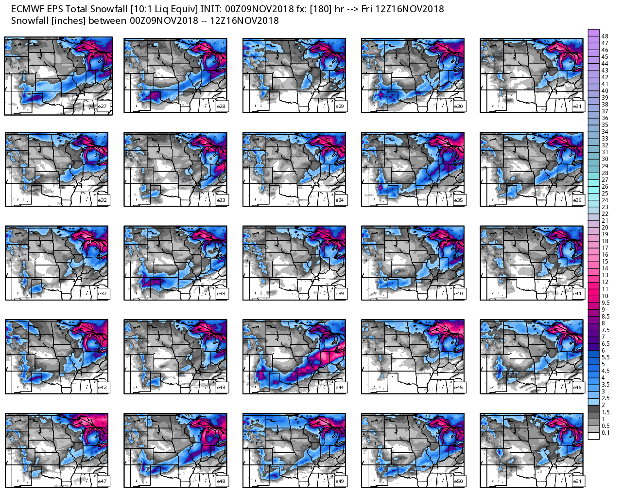
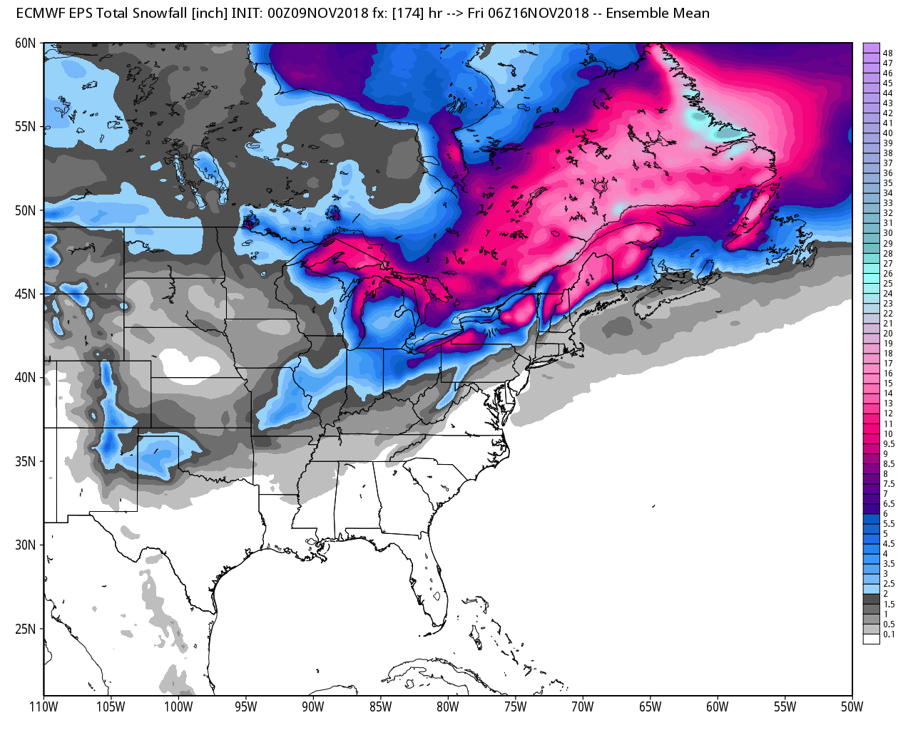
The EC model showing you the mean average of all ensembles.
Notice how the mean average has the heavier snow to our north.
Am I seeing any trends in the data?
The guidance data remains fairly stable. They are all showing some type of precipitation event across the southern United States into the eastern United States.
They have been consistent in showing this. That has not changed.
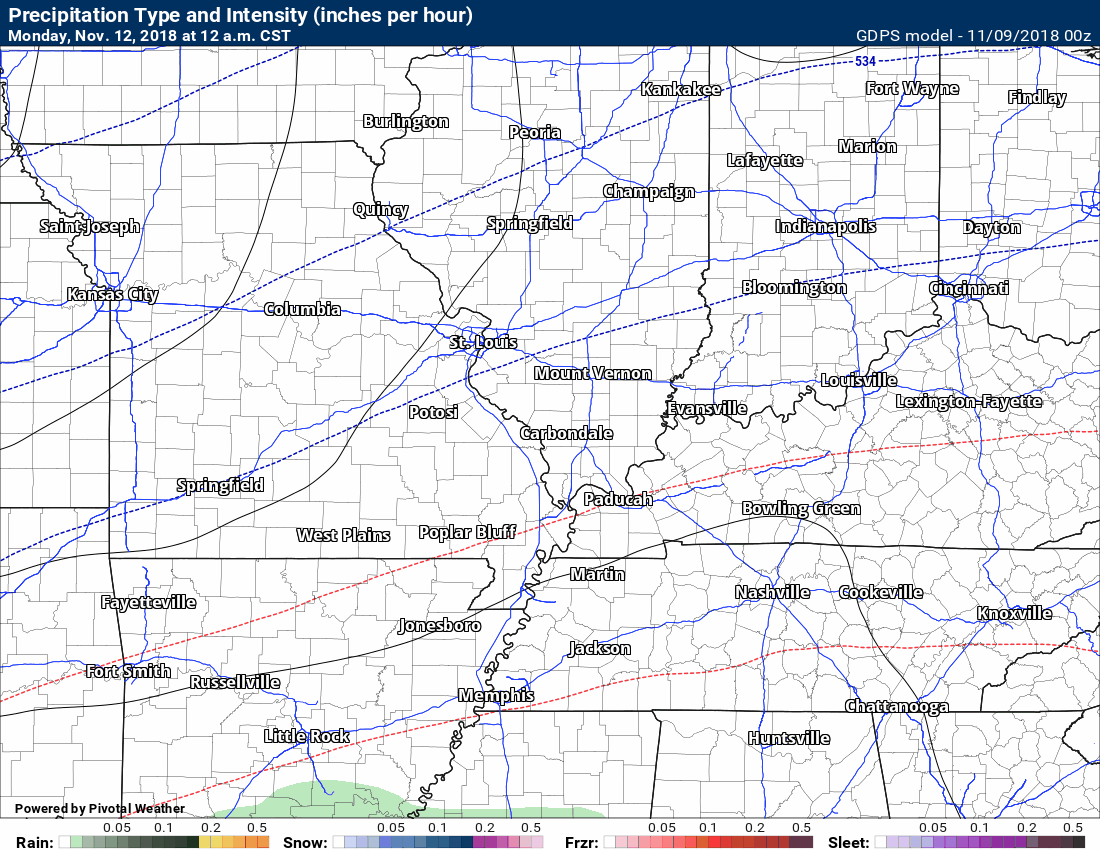
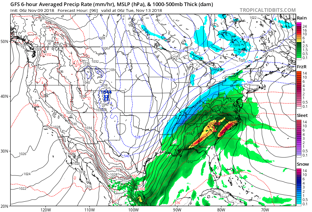
Here is the Canadian model animation. It has a full blown winter storm.
The time-stamp is located in the upper left portion of the graphic.
Green is rain. Blue is snow. Pink/purple is sleet or freezing rain (or both)
Here is the GFS model guidance animation.
The GFS has been consistently showing this system to mainly impact our southern and eastern counties.
Here is a wider view (late Monday night)
Blue is snow. Green is rain.
These model runs fluctuate. Some runs take it south of us. This particular model runs four times each day.
Monitor updates through the weekend. I will be updating the subscriber blog each day.
Precipitation event early next week.
Storm dates to monitor from our long range team of meteorologists.
Updated November outlook for subscribers!
![]()

I bring these to you from the BAMwx team. They are excellent long-range forecasters.
Remember, long-range outlooks are a bit of skill, understanding weather patterns, and luck combined. It is not an exact science.

This product is for subscribers.
Subscribe at www.weathertalk.com
Subscriber graphics can be viewed on this page CLICK HERE

This product is for subscribers.

This product is for subscribers.
Subscribe at www.weathertalk.com
Subscriber graphics can be viewed on this page CLICK HERE
![]()
.
Fall Outlook!
These products are for subscribers.
November temperature and precipitation outlook
November temperature outlook
November precipitation outlook
.These products are for subscribers.
![]()

A new weather podcast is now available! Weather Geeks (which you might remember is on The Weather Channel each Sunday)
To learn more visit their website. Click here.
![]()

WeatherBrains Episode 667
Tonight’s Guest WeatherBrain started her interest in weather in middle school when she was living in Florida and became fascinated with hurricanes. She graduated in 1995 with a B.S. in meteorology from Penn State University. She also has worked in radio as a broadcast meteorologist for the past 20 years. She started her career at the Weather Channel, but now works for the Storm Report Radio Network in Ohio. Jen Narramore, welcome to WeatherBrains!
Other discussions in this weekly podcast include topics like:
- Overnight tornadoes and severe thunderstorms in AL, MS, LA and TN
- Arctic blast coming soon to eastern U. S.
- Kevin takes issue with social media
- Tornado alley shifting east?
- Astronomy Outlook with Tony Rice
- and more!
Link to their website https://weatherbrains.com/
Previous episodes can be viewed by clicking here.
Link to their website https://weatherbrains.com/
Previous episodes can be viewed by clicking here.

We offer interactive local city live radars and regional radars. If a radar does not update then try another one. If a radar does not appear to be refreshing then hit Ctrl F5. You may also try restarting your browser.
The local city view radars also have clickable warnings.
During the winter months, you can track snow and ice by clicking the winterize button on the local city view interactive radars.
You may email me at beaudodson@usawx.com
Find me on Facebook!

Find me on Twitter!

Did you know that a portion of your monthly subscription helps support local charity projects?
You can learn more about those projects by visiting the Shadow Angel Foundation website and the Beau Dodson News website.

I encourage subscribers to use the app vs regular text messaging. We have found text messaging to be delayed during severe weather. The app typically will receive the messages instantly. I recommend people have three to four methods of receiving their severe weather information.
Remember, my app and text alerts are hand typed and not computer generated. You are being given personal attention during significant weather events.
