
WeatherTalk monthly operating costs can top $2000.00. Your $5 subscription helps pay for those costs. I work for you.
The $5 will allow you to register up to seven phones!
For $5 a month you can receive the following. You may choose to receive these via your WeatherTalk app or regular text messaging.
Severe weather app/text alerts from my keyboard to your app/cell phone. These are hand typed messages from me to you. During tornado outbreaks, you will receive numerous app/text messages telling you exactly where the tornado is located.
- Daily forecast app/texts from my computer to your app/cell phone.
- Social media links sent directly to your app/cell phone. When I update the blog, videos, or Facebook you will receive the link.
- AWARE emails. These emails keep you well ahead of the storm. They give you several days of lead time before significant weather events.
- Direct access to Beau via text and email. Your very own personal meteorologist. I work for you!
- Missouri and Ohio Valley centered video updates
- Long-range weather videos
- Week one, two, three and four temperature and precipitation outlooks.
Monthly outlooks. - Your subscription also will help support several local charities.
Would you like to subscribe? Subscribe at www.beaudodsonweather.com
Typical progression on a severe weather day for subscribers.


I encourage subscribers to use the app vs regular text messaging. We have found text messaging to be delayed during severe weather. The app typically will receive the messages instantly. I recommend people have three to four methods of receiving their severe weather information.
Remember, my app and text alerts are hand typed and not computer generated. You are being given my personal attention during significant weather events.

WWW.WEATHERTALK.COM subscribers, here is my day to day schedule for your weather products.
These are bonus videos and maps for subscribers. I bring these to you from the BAMwx team. I pay them to help with videos.
The Ohio and Missouri Valley videos cover most of our area. They do not have a specific Tennessee Valley forecast but may add one in the future.
The long-range video is technical. Over time, you can learn a lot about meteorology from the long range video. Just keep in mind, it is a bit more technical.


.
![]()

This forecast was updated at 8 AM on Wednesday, November 5, 2018
November 8, 2018
Thursday forecast: A mix of sun and clouds. Clouds thickening. A chance of a light shower. Colder.
Temperatures: MO ~ 45 to 50 IL ~ 45 to 50 KY ~ 46 to 52 TN ~ 48 to 52
What is the chance of precipitation? MO ~ 20% IL ~ 20% KY ~ 20% TN ~ 20%
Coverage of precipitation: Isolated to widely scattered
Is snow or ice anticipated? No
Wind: Northeast at 6 to 12 mph
What impacts are anticipated from the weather? A wet roadway or two.
My confidence in the forecast verifying: High
Is severe weather expected? No
The NWS defines severe weather as 58 mph wind or great, 1″ hail or larger, and/or tornadoes
Should I cancel my outdoor plans? No
UV Index: 5 Moderate
Sunrise: 6:27 AM
Thursday Night Forecast Details:
Forecast: Cloudy. Rain showers likely. Rain may mix with wet snowflakes along and north of I64 in southern Illinois. No travel problems. Rain totals a trace to 0.20″.
Temperatures: MO ~ 32 to 36 IL ~ 32 to 36 KY ~ 34 to 38 TN ~ 36 to 40
What is the chance of precipitation? MO ~ 60% IL ~ 0% KY ~ 60% TN ~ 60%
Coverage of precipitation: Scattered to perhaps numerous
Frost Risk: No
Is snow or ice anticipated? Nothing of significance
Wind: North at 8 to 16 mph
What impacts are anticipated from the weather? Wet roadways.
My confidence in the forecast verifying: High
Is severe weather expected? No
The NWS defines severe weather as 58 mph wind or great, 1″ hail or larger, and/or tornadoes
Should I cancel my outdoor plans? No, but monitor radars and updates.
Sunset: 4:50 PM
Moonrise: 7:16 AM New
Moonset: 5:55 PM

November 9, 2018
Friday forecast: Morning showers ending. Cold with well below normal temperatures. Clouds clearing through the day.
Temperatures: MO ~ 43 to 46 IL ~ 43 to 46 KY ~ 44 to 48 TN ~ 48 to 50
What is the chance of precipitation? MO ~ 20% IL ~ 30% KY ~ 30% TN ~ 20%
Coverage of precipitation: Ending
Is snow or ice anticipated? Most likely no
Wind: North and northwest at 6 to 12 mph
What impacts are anticipated from the weather? A few morning wet roadways.
My confidence in the forecast verifying: High
Is severe weather expected? No
The NWS defines severe weather as 58 mph wind or great, 1″ hail or larger, and/or tornadoes
Should I cancel my outdoor plans? No
UV Index: 4 to 6 Moderate
Sunrise: 6:28 AM
Friday Night Forecast Details:
Forecast: Mostly clear with a hard freeze likely. Cold. Well below normal temperatures.
Temperatures: MO ~ 23 to 25 IL ~ 23 to 25 KY ~ 24 to 26 TN ~ 24 to 28
What is the chance of precipitation? MO ~ 0% IL ~ 0% KY ~ 0% TN ~ 0%
Coverage of precipitation: None
Frost Risk: A hard freeze likely
Is snow or ice anticipated? No
Wind: Northwest at 3 to 6 mph
What impacts are anticipated from the weather? Hard freeze
My confidence in the forecast verifying: High
Is severe weather expected? No
The NWS defines severe weather as 58 mph wind or great, 1″ hail or larger, and/or tornadoes
Should I cancel my outdoor plans? No
Sunset: 4:49 PM
Moonrise: 8:16 AM Waxing Crescent
Moonset: 6:36 PM
November 10, 2018
Saturday forecast: Mostly sunny and cold with well below normal temperatures. These highs are colder than normal January highs.
Temperatures: MO ~ 38 to 44 IL ~ 38 to 44 KY ~ 40 to 45 TN ~ 40 to 45
What is the chance of precipitation? MO ~ 0% IL ~ 0% KY ~ 0% TN ~ 0%
Coverage of precipitation: None
Is snow or ice anticipated? No
Wind: North at 6 to 12 mph. Winds becoming variable through the day.
What impacts are anticipated from the weather? None
My confidence in the forecast verifying: High
Is severe weather expected? No
The NWS defines severe weather as 58 mph wind or great, 1″ hail or larger, and/or tornadoes
Should I cancel my outdoor plans? No
UV Index: 3 to 4 Moderate
Sunrise: 6:29 AM
Saturday Night Forecast Details:
Forecast: Mostly clear. Cold. A hard freeze.
Temperatures: MO ~ 23 to 26 IL ~ 23 to 26 KY ~ 23 to 26 TN ~ 23 to 26
What is the chance of precipitation? MO ~ 0% IL ~ 0% KY ~ 0% TN ~ 0%
Coverage of precipitation: None
Frost Risk: Another hard freeze
Is snow or ice anticipated? No
Wind: Variable at 4 to 8 mph
What impacts are anticipated from the weather? Hard freeze.
My confidence in the forecast verifying: High
Is severe weather expected? No
The NWS defines severe weather as 58 mph wind or great, 1″ hail or larger, and/or tornadoes
Should I cancel my outdoor plans? No
Sunset: 4:48 PM
Moonrise: 9:15 AM Waxing Crescent
Moonset: 7:21 PM
November 11, 2018
Sunday forecast: A mix of sun and clouds. Chilly. Well below normal temperatures.
Temperatures: MO ~ 44 to 48 IL ~ 44 to 48 KY ~ 46 to 50 TN ~ 46 to 52
What is the chance of precipitation? MO ~ 0% IL ~ 0% KY ~ 0% TN ~ 0%
Coverage of precipitation: None
Is snow or ice anticipated? No
Wind: South and southeast at 5 to 10 mph
What impacts are anticipated from the weather? None
My confidence in the forecast verifying: Medium
Is severe weather expected? No
The NWS defines severe weather as 58 mph wind or great, 1″ hail or larger, and/or tornadoes
Should I cancel my outdoor plans? No
UV Index: 3 to 4 Moderate
Sunrise: 6:30 AM
Sunday Night Forecast Details:
Forecast: Partly cloudy to cloudy. A shower or snow shower possible. Cold.
Temperatures: MO ~ 28 to 34 IL ~ 28 to 34 KY ~ 32 to 36 TN ~ 32 to 36
What is the chance of precipitation? MO ~ 20% IL ~ 20% KY ~ 20% TN ~ 20%
Coverage of precipitation: Isolated
Frost Risk: A freeze again possible
Is snow or ice anticipated? A chance of snow showers, but accumulation is unlikely
Wind: Northeast at 3 to 6 mph
What impacts are anticipated from the weather? Perhaps wet roadways.
My confidence in the forecast verifying: Medium.
Is severe weather expected? No
The NWS defines severe weather as 58 mph wind or great, 1″ hail or larger, and/or tornadoes
Should I cancel my outdoor plans? No
Sunset: 4:47 PM
Moonrise: 10:09 AM Waxing Crescent
Moonset: 8:08 PM
November 12, 2018
Monday forecast: Cloudy. Showers possible.
Temperatures: MO ~ 44 to 48 IL ~ 45 to 50 KY ~ 48 to 52 TN ~ 48 to 52
What is the chance of precipitation? MO ~ 30% IL ~ 30% KY ~ 30% TN ~ 30%
Coverage of precipitation: Scattered
Is snow or ice anticipated? Monitor updates
Wind: North at 7 to 14 mph
What impacts are anticipated from the weather? Wet roadways.
My confidence in the forecast verifying: LOW
Is severe weather expected? No
The NWS defines severe weather as 58 mph wind or great, 1″ hail or larger, and/or tornadoes
Should I cancel my outdoor plans? No
UV Index: 1 to 3 Low
Sunrise: 6:31 AM
Monday Night Forecast Details:
Forecast: Mostly cloudy. A chance of precipitation. Cold.
Temperatures: MO ~ 28 to 32 IL ~ 28 to 32 KY ~ 30 to 34 TN ~ 30 to 34
What is the chance of precipitation? MO ~ 30% IL ~ 30% KY ~ 30% TN ~ 30%
Coverage of precipitation:
Frost Risk: No
Is snow or ice anticipated? Possible
Wind: North and northwest at 7 to 14 mph and gusty
What impacts are anticipated from the weather? Monitor updates
My confidence in the forecast verifying: LOW
Is severe weather expected? No
The NWS defines severe weather as 58 mph wind or great, 1″ hail or larger, and/or tornadoes
Should I cancel my outdoor plans? Monitor updates
Sunset: 4:47 PM
Moonrise: 10:58 AM Waxing Crescent
Moonset: 9:09 PM
November 13, 2018
Tuesday forecast: Mostly cloudy. Cold. A chance of precipitation. Cold. Well below normal temperatures.
Temperatures: MO ~ 35 to 40 IL ~ 35 to 40 KY ~ 35 to 40 TN ~ 35 to 40
What is the chance of precipitation? MO ~ 20% IL ~ 20% KY ~ 20% TN ~ 20%
Coverage of precipitation:
Is snow or ice anticipated? Possible
Wind: Northeast at 10 to 20 mph and gusty
What impacts are anticipated from the weather? Monitor
My confidence in the forecast verifying: LOW
Is severe weather expected? No
The NWS defines severe weather as 58 mph wind or great, 1″ hail or larger, and/or tornadoes
Should I cancel my outdoor plans? Monitor
UV Index: 2 to 3 Low
Sunrise: 6:32 AM
Tuesday Night Forecast Details:
Forecast: Clearing and cold.
Temperatures: MO ~ 23 to 26 IL ~ 23 to 26 KY ~ 24 to 26 TN ~ 24 to 28
What is the chance of precipitation? MO ~ 10% IL ~ 10% KY ~ 10% TN ~ 10%
Coverage of precipitation: Most likely none, but monitor updates
Frost Risk:
Is snow or ice anticipated? Monitor updates
Wind: Northwest at 8 to 16 mph
What impacts are anticipated from the weather?
My confidence in the forecast verifying: LOW
Is severe weather expected? No
The NWS defines severe weather as 58 mph wind or great, 1″ hail or larger, and/or tornadoes
Should I cancel my outdoor plans? No
Sunset: 4:46 PM
Moonrise: 11:43 AM Waxing Crescent
Moonset: 9:53 PM

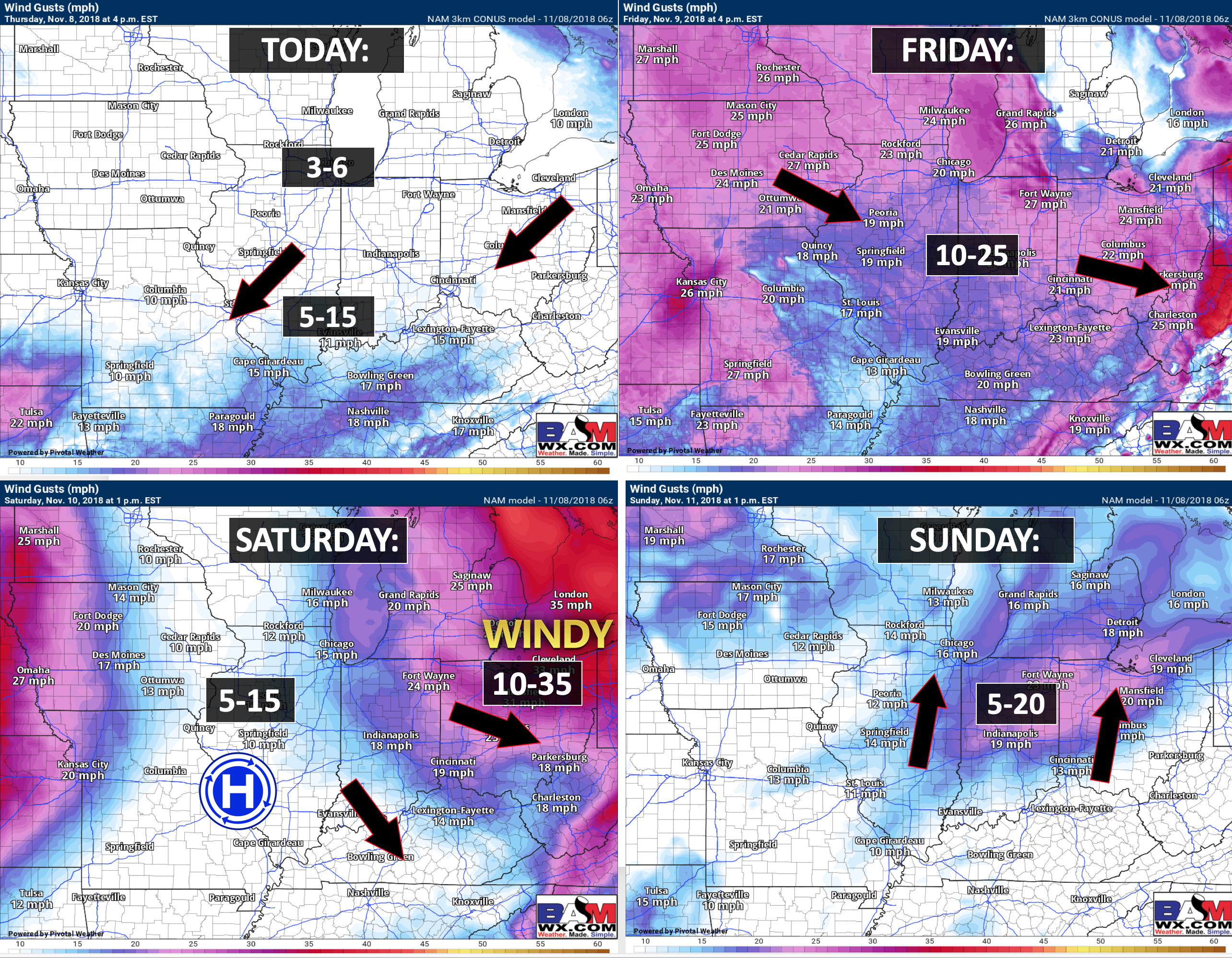
Wind forecast
The Weather Observatory will be holding two open houses for adults and children. Weather permitting, the open house will be Saturday, December 1st.
Class of 1988 (Massac County High School). I will be having a special open house for you on Friday, November 30th (the night before the other open house)

Learn more about the UV index readings. Click here.

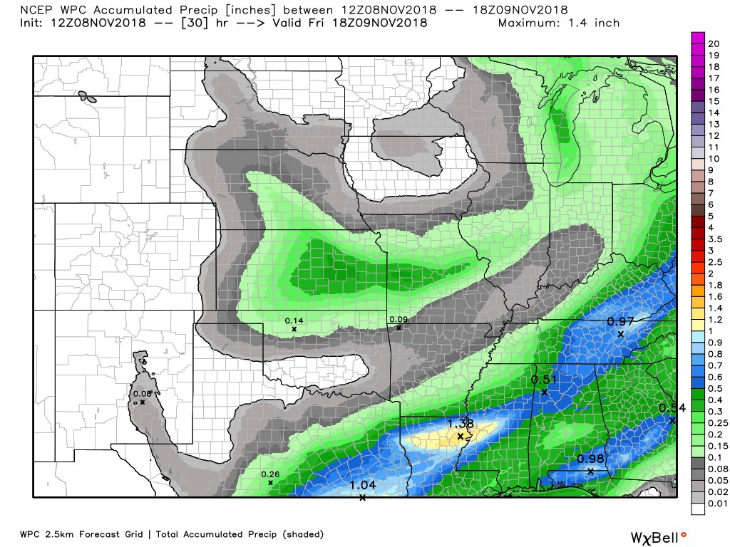
Here is the WPC/NOAA rainfall outlook
Light rain is possible today and even more likely this afternoon and tonight.
Rain totals will be light. Trace amounts to 0.25″ are anticipated.
Here is the WPC rainfall outlook through Friday morning.
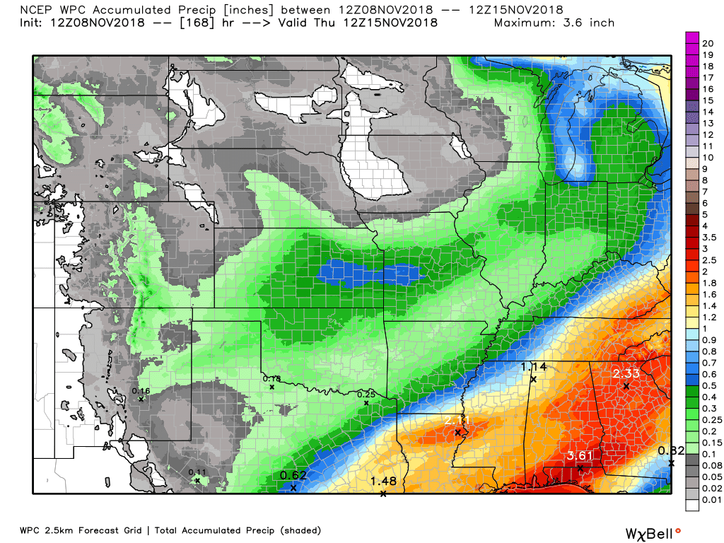
Let’s look at totals through Tuesday morning. We will have some additional precipitation chances.
Generally, rain totals are forecast to be on the light side. There could be some higher amounts from NW TN into south central KY. Rain totals of 0.20″ to 0.35″ are possible in those areas. Perhaps a bit higher the further southeast you travel.
The next best chance of precipitation will be Monday into Tuesday. Low confidence in the eventual outcome of that system.

Subscribers, do you need a forecast for an outdoor event?


We offer interactive local city live radars and regional radars.
If a radar does not update then try another one. If a radar does not appear to be refreshing then hit Ctrl F5 on your keyboard.
You may also try restarting your browser. The local city view radars also have clickable warnings.
During the winter months, you can track snow and ice by clicking the winterize button on the local city view interactive radars.

Questions? Broken links? Other questions?
You may email me at beaudodson@usawx.com

The National Weather Service defines a severe thunderstorm as one that produces quarter size hail or larger, 58 mph winds or greater, and/or a tornado.
Today through next Thursday: No severe storms.
Interactive live weather radar page. Choose the city nearest your location. If one of the cities does not work then try a nearby one. Click here.
National map of weather watches and warnings. Click here.
Storm Prediction Center. Click here.
Weather Prediction Center. Click here.

Live lightning data: Click here.

Interactive GOES R satellite. Track clouds. Click here.

Here are the latest local river stage forecast numbers Click Here.
Here are the latest lake stage forecast numbers for Kentucky Lake and Lake Barkley Click Here.

- Rain chances today and tonight.
- Winter temperatures.
- Hard freeze.
- Monitoring Monday and Tuesday precipitation event
An interesting weather pattern is developing for the region.
The winter storm outlook is for subscribers.
Short range outlook:
First, we have a weak system that will pass through the region today and tonight.
This system will produce clouds and some rain showers. Most of the rain showers will occur tonight. With that said, we do have some rain showers on the radar this morning. Most of the precipitation was located in southeast Missouri. It was weakening.
High temperatures today will rise into the 50’s. Well below normal temperatures.
Rain chances increase tonight. The rain will be light. Rain totals area-wide will range from a trace to perhaps as much as 0.20″. I can’t rule out somewhat higher totals over northwest Tennessee into the LBL area and then east from there.
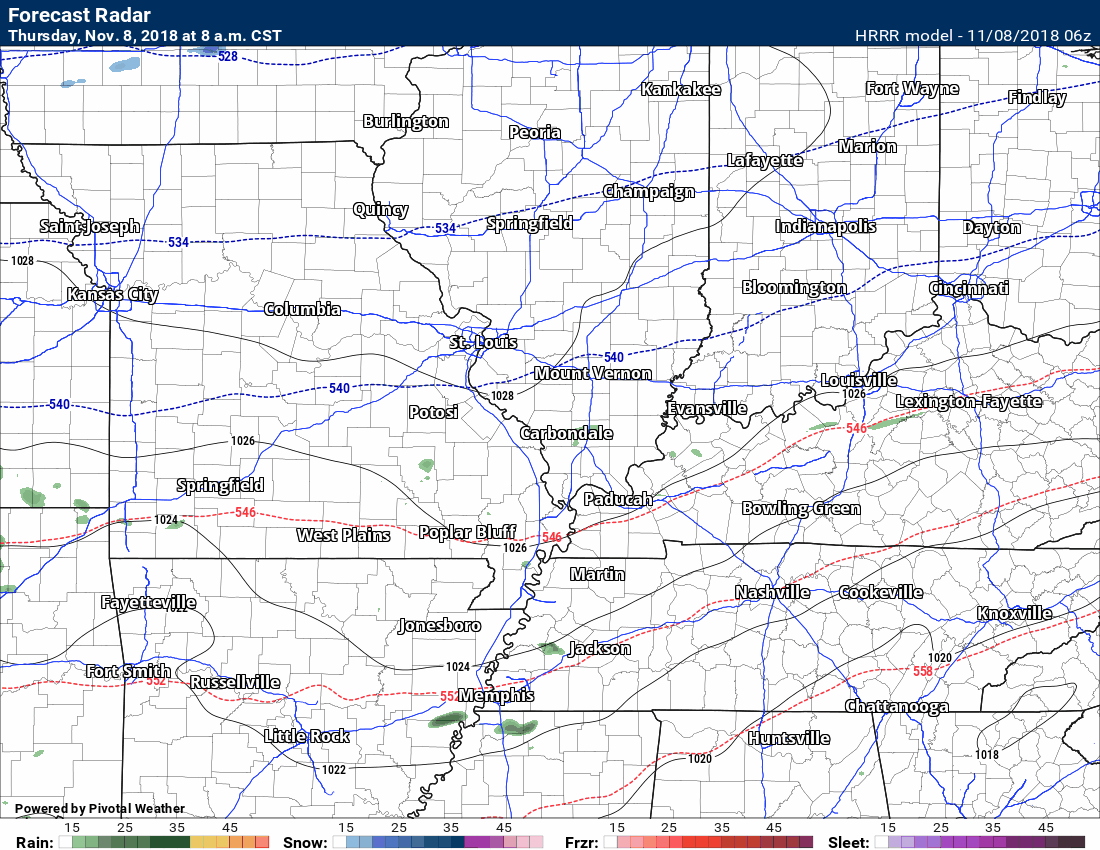
Let’s look at some future-cast radars. These are model depictions of what radar might look like over the coming 24 hours.
Hrrr model. This is a short-range high-resolution model.
Green is rain. Yellow is moderate rain. Blue is snow.
You can see the time-stamp at the upper left portion of the graphic. Check out the snow to our north! Some areas may receive a dusting up to an inch.
Locally, this is mostly a rain event. I can’t rule out some wet snowflakes along or north of I64, but no big deal.
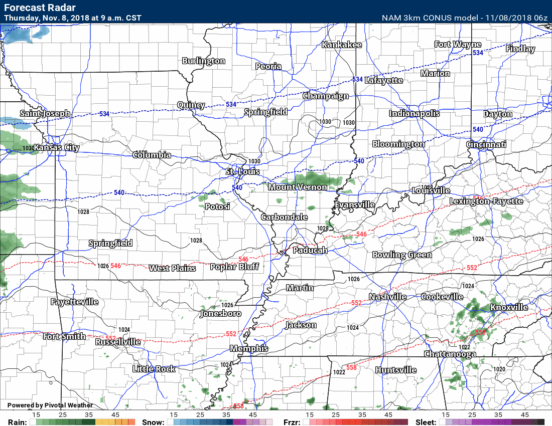
This next animation is the NAM model. This is another model that I use to monitor forecast conditions.
Models are similar in their depiction of this light rain event.
Click animations to enlarge.
The big weather story, over the coming days, will be winter-like temperatures.
Keep in mind, January high temperatures are normally in the 40’s with lows in the 20’s. We will be hitting those marks in the coming days. It will not feel like November.
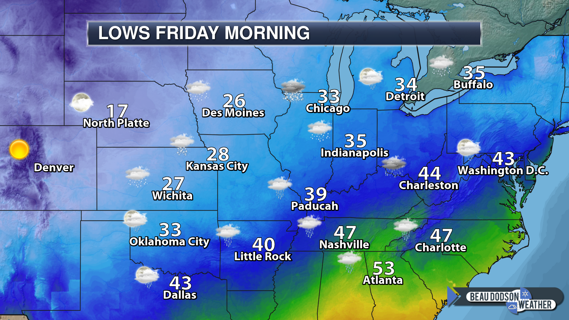
Lows tonight
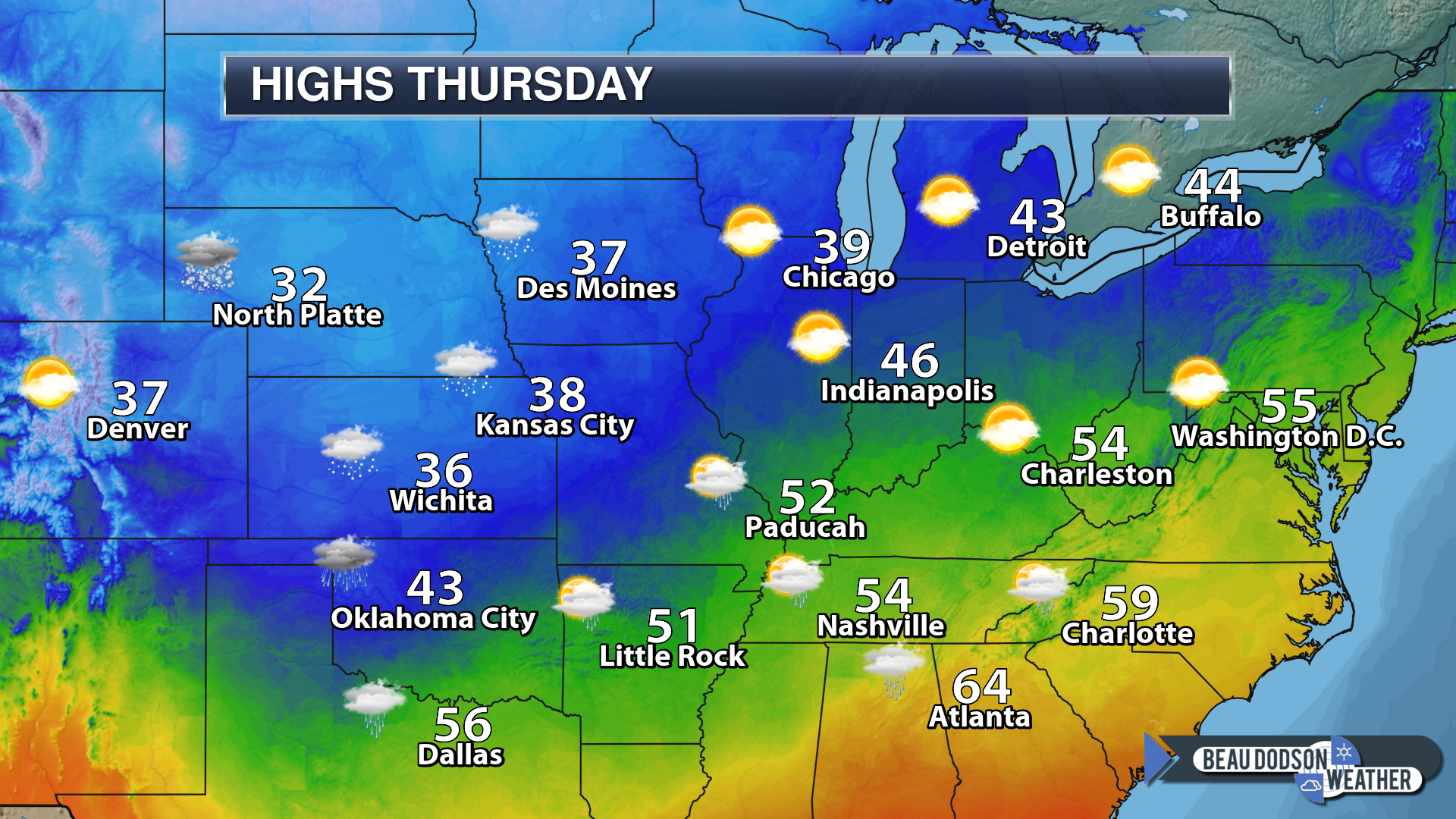
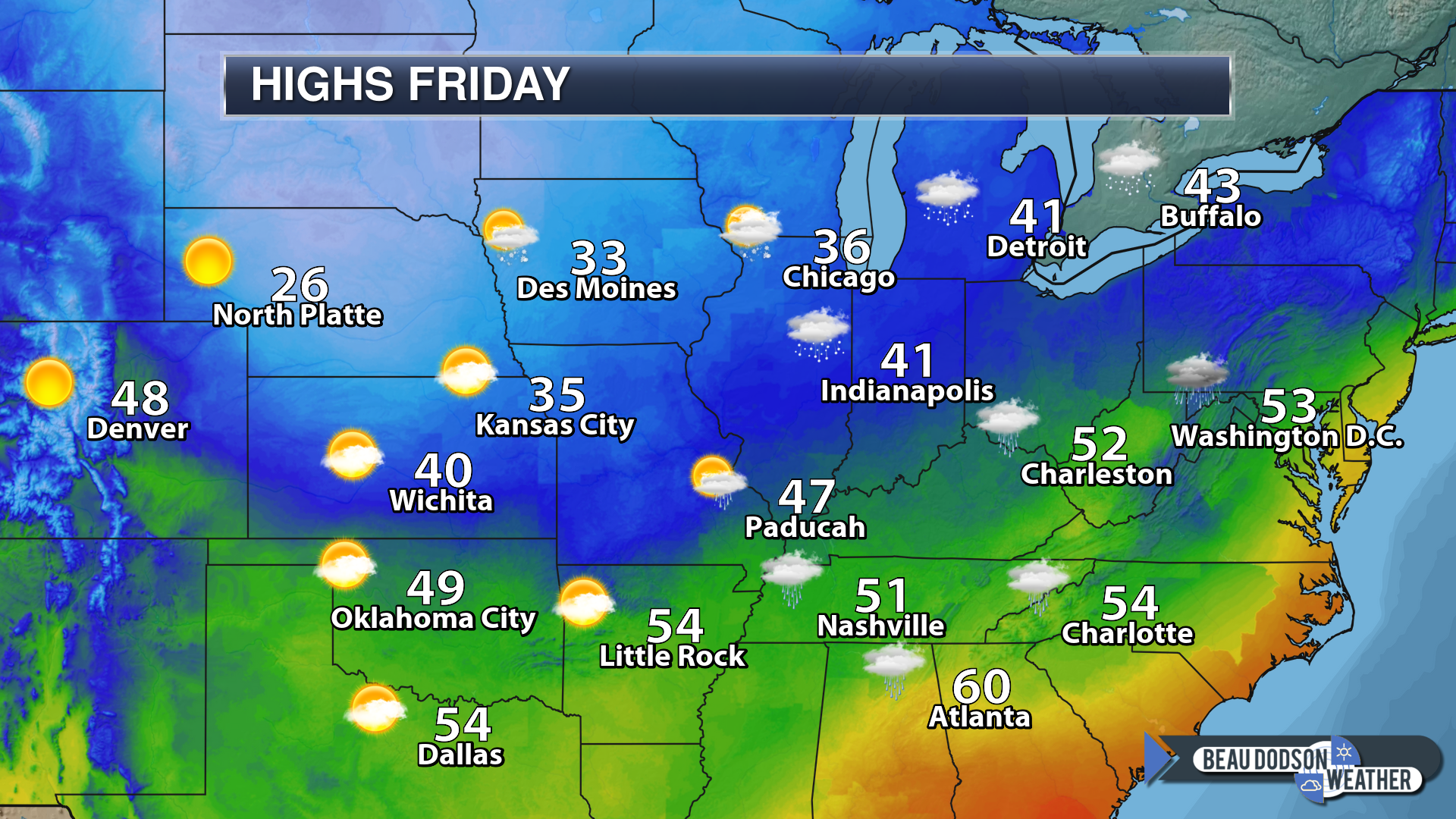
Highs on Friday
Lows on Friday night

Normal highs, for this time of the year, are in the lower 60’s.
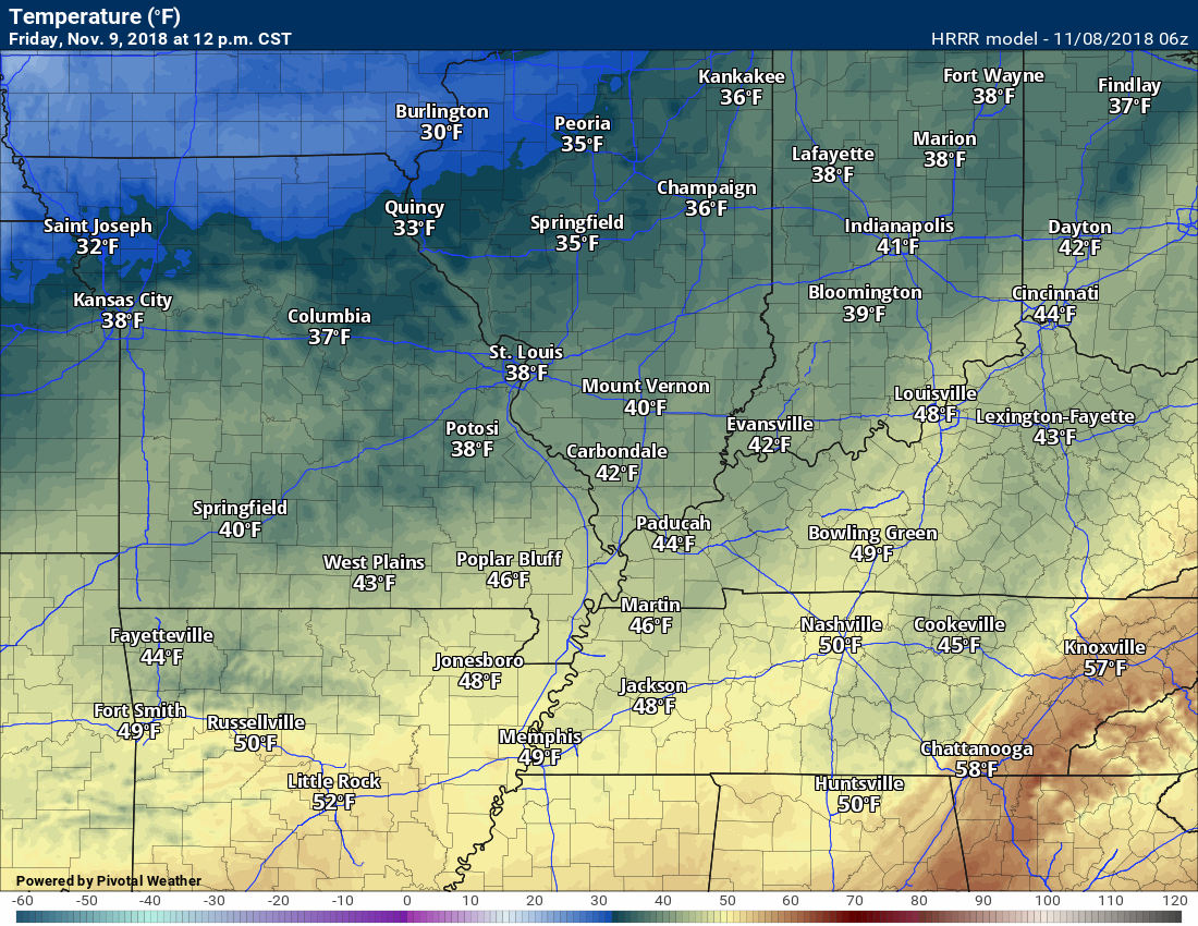
Here is the 12 PM Friday temperature forecast
12 PM Saturday temperature forecast

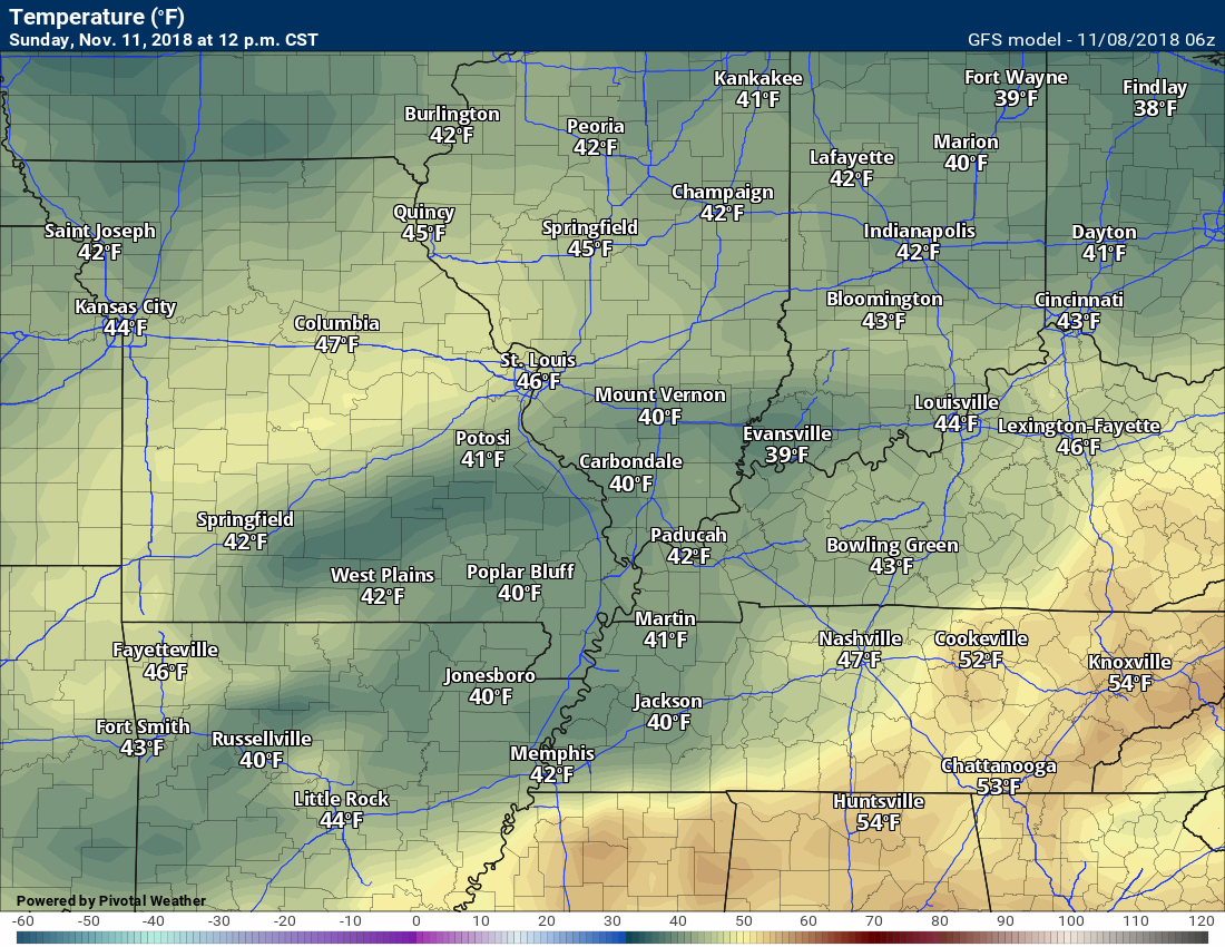
12 PM Sunday temperature forecast
12 PM Monday temperature forecast (less confidence in Monday’s temperatures)

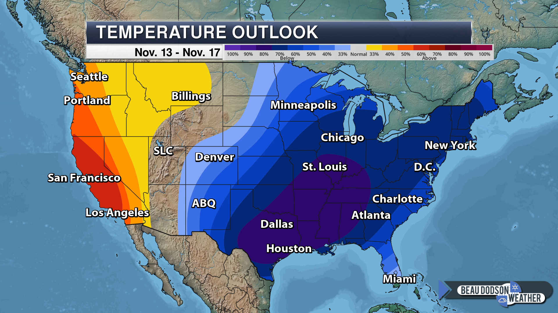
NOAA’s November 13th through November 17th temperature outlook is a cold one. An impressive outbreak of cold air for this time of the year.
This graphic does not tell you actual temperatures. It tells you the chances of temperatures being above or below normal. High chance of below normal temperatures.
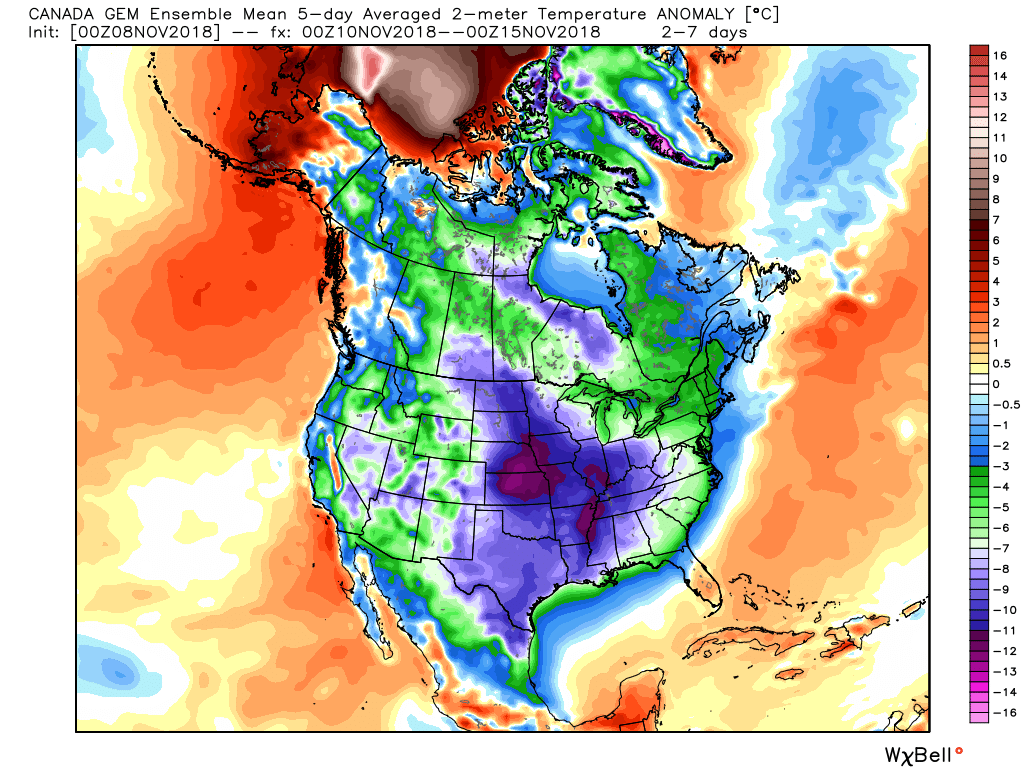
The EC long-range model output agrees. Cold air will be with us for a while.
These are 5-day temperature averages. This is from November 10th to November 15h.
Well below normal temperatures.
That purple area represents a cold nation. Well below normal temperatures. Anywhere from 10 to 15 degrees below the seasonal norms.
Notice Alaska is warmer than normal. Typically, when Alaska is warmer than normal then we are colder than normal.
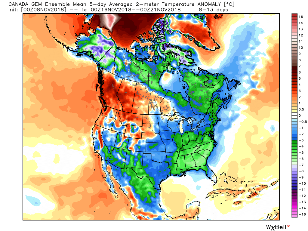
This next graphic is from November 16th through the 21st. Again, the EC shows below normal temperatures.
I do think we see temperatures moderate a bit. It won’t be as cold. The model trend has been warmer in this time frame.
For now, the EC is still showing below normal temperatures. Let’s monitor trends over the coming days. We may see the degree of the below normal anomalies moderate some.
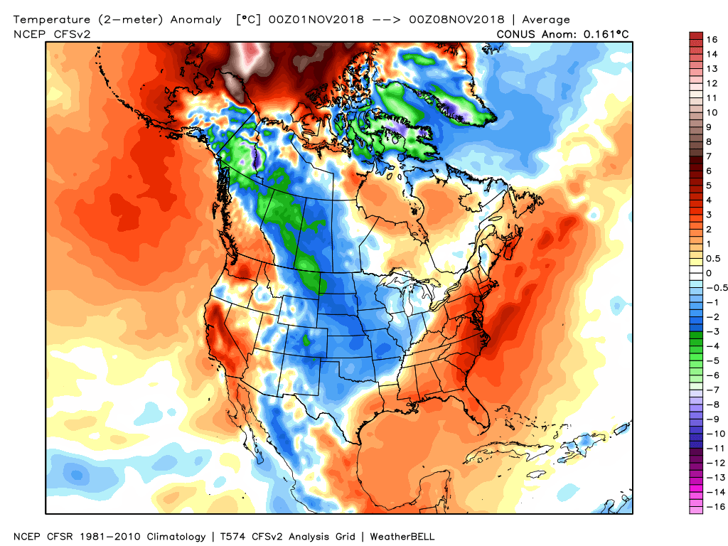
Here is the month to date temperature anomalies. How many degrees above or below normal have temperatures been since November 1st?
The coming days will knock us into the well below normal temperatures (month-to-date).
Precipitation event early next week.
Storm dates to monitor from our long range team of meteorologists.
Updated November outlook for subscribers!
![]()

I bring these to you from the BAMwx team. They are excellent long-range forecasters.
Remember, long-range outlooks are a bit of skill, understanding weather patterns, and luck combined. It is not an exact science.

This product is for subscribers.
Subscribe at www.weathertalk.com
Subscriber graphics can be viewed on this page CLICK HERE

This product is for subscribers.

This product is for subscribers.
Subscribe at www.weathertalk.com
Subscriber graphics can be viewed on this page CLICK HERE
![]()
.
Fall Outlook!
These products are for subscribers.
November temperature and precipitation outlook
November temperature outlook
November precipitation outlook
.These products are for subscribers.
![]()

A new weather podcast is now available! Weather Geeks (which you might remember is on The Weather Channel each Sunday)
To learn more visit their website. Click here.
![]()

WeatherBrains Episode 667
Tonight’s Guest WeatherBrain started her interest in weather in middle school when she was living in Florida and became fascinated with hurricanes. She graduated in 1995 with a B.S. in meteorology from Penn State University. She also has worked in radio as a broadcast meteorologist for the past 20 years. She started her career at the Weather Channel, but now works for the Storm Report Radio Network in Ohio. Jen Narramore, welcome to WeatherBrains!
Other discussions in this weekly podcast include topics like:
- Overnight tornadoes and severe thunderstorms in AL, MS, LA and TN
- Arctic blast coming soon to eastern U. S.
- Kevin takes issue with social media
- Tornado alley shifting east?
- Astronomy Outlook with Tony Rice
- and more!
Link to their website https://weatherbrains.com/
Previous episodes can be viewed by clicking here.
Link to their website https://weatherbrains.com/
Previous episodes can be viewed by clicking here.

We offer interactive local city live radars and regional radars. If a radar does not update then try another one. If a radar does not appear to be refreshing then hit Ctrl F5. You may also try restarting your browser.
The local city view radars also have clickable warnings.
During the winter months, you can track snow and ice by clicking the winterize button on the local city view interactive radars.
You may email me at beaudodson@usawx.com
Find me on Facebook!

Find me on Twitter!

Did you know that a portion of your monthly subscription helps support local charity projects?
You can learn more about those projects by visiting the Shadow Angel Foundation website and the Beau Dodson News website.

I encourage subscribers to use the app vs regular text messaging. We have found text messaging to be delayed during severe weather. The app typically will receive the messages instantly. I recommend people have three to four methods of receiving their severe weather information.
Remember, my app and text alerts are hand typed and not computer generated. You are being given personal attention during significant weather events.
