
WeatherTalk monthly operating costs can top $2000.00. Your $5 subscription helps pay for those costs. I work for you.
The $5 will allow you to register up to seven phones!
For $5 a month you can receive the following. You may choose to receive these via your WeatherTalk app or regular text messaging.
Severe weather app/text alerts from my keyboard to your app/cell phone. These are hand typed messages from me to you. During tornado outbreaks, you will receive numerous app/text messages telling you exactly where the tornado is located.
- Daily forecast app/texts from my computer to your app/cell phone.
- Social media links sent directly to your app/cell phone. When I update the blog, videos, or Facebook you will receive the link.
- AWARE emails. These emails keep you well ahead of the storm. They give you several days of lead time before significant weather events.
- Direct access to Beau via text and email. Your very own personal meteorologist. I work for you!
- Missouri and Ohio Valley centered video updates
- Long-range weather videos
- Week one, two, three and four temperature and precipitation outlooks.
Monthly outlooks. - Your subscription also will help support several local charities.
Would you like to subscribe? Subscribe at www.beaudodsonweather.com
Typical progression on a severe weather day for subscribers.


I encourage subscribers to use the app vs regular text messaging. We have found text messaging to be delayed during severe weather. The app typically will receive the messages instantly. I recommend people have three to four methods of receiving their severe weather information.
Remember, my app and text alerts are hand typed and not computer generated. You are being given my personal attention during significant weather events.

WWW.WEATHERTALK.COM subscribers, here is my day to day schedule for your weather products.
These are bonus videos and maps for subscribers. I bring these to you from the BAMwx team. I pay them to help with videos.
The Ohio and Missouri Valley videos cover most of our area. They do not have a specific Tennessee Valley forecast but may add one in the future.
The long-range video is technical. Over time, you can learn a lot about meteorology from the long range video. Just keep in mind, it is a bit more technical.


.
![]()

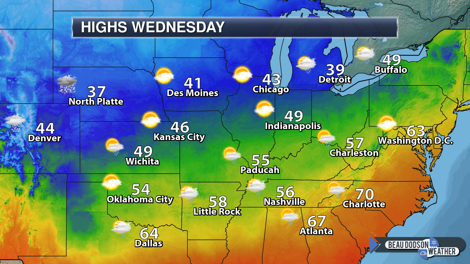
This forecast was updated at 8 AM on Wednesday, November 5, 2018
November 7, 2018
Wednesday forecast: Some morning clouds. Greatest cloud cover over the Bootheel into Kentucky4 and Tennessee. A few light showers, esp in the Missouri Bootheel into Kentucky and Tennessee. Cool temperatures.
Temperatures: MO ~ 52 to 56 IL ~ 52 to 55 KY ~ 54 to 58 TN ~ 54 to 58
What is the chance of precipitation? MO ~ 20% IL ~ 30% KY ~ 40% TN ~ 40%
Coverage of precipitation: Scattered
Is snow or ice anticipated? No
Wind: North and northeast at 7 to 14 mph
What impacts are anticipated from the weather? Wet roadways.
My confidence in the forecast verifying: Medium
Is severe weather expected? No
The NWS defines severe weather as 58 mph wind or great, 1″ hail or larger, and/or tornadoes
Should I cancel my outdoor plans? No
UV Index: 5 to 6 moderate to high
Sunrise: 6:26 AM
Wednesday Night Forecast Details:
Forecast: A few clouds, otherwise clearing. Cold.
Temperatures: MO ~ 30 to 36 IL ~ 30 to 35 KY ~ 33 to 36 TN ~ 34 to 38
What is the chance of precipitation? MO ~ 0% IL ~ 0% KY ~ 0% TN ~ 0%
Coverage of precipitation: None
Frost Risk: Frost
Is snow or ice anticipated? No
Wind: North and northeast at 4 to 8 mph with gusts to 14
What impacts are anticipated from the weather? Lower visibility if fog forms
My confidence in the forecast verifying: Medium
Is severe weather expected? No
The NWS defines severe weather as 58 mph wind or great, 1″ hail or larger, and/or tornadoes
Should I cancel my outdoor plans? No
Sunset: 4:51 PM
Moonrise: 6:12 AM Waning Gibbous
Moonset: 5:18 PM
November 8, 2018
Thursday forecast: A mix of sun and clouds. A chance of a light shower. Colder.
Temperatures: MO ~ 45 to 50 IL ~ 45 to 50 KY ~ 46 to 52 TN ~ 48 to 52
What is the chance of precipitation? MO ~ 20% IL ~ 20% KY ~ 20% TN ~ 20%
Coverage of precipitation: Isolated to widely scattered
Is snow or ice anticipated? No
Wind: Northeast at 6 to 12 mph
What impacts are anticipated from the weather? A wet roadway or two.
My confidence in the forecast verifying: Medium
Is severe weather expected? No
The NWS defines severe weather as 58 mph wind or great, 1″ hail or larger, and/or tornadoes
Should I cancel my outdoor plans? No
UV Index: 5 Moderate
Sunrise: 6:27 AM
Thursday Night Forecast Details:
Forecast: Cloudy. Rain showers developing. Cold.
Temperatures: MO ~ 32 to 36 IL ~ 32 to 36 KY ~ 34 to 38 TN ~ 36 to 40
What is the chance of precipitation? MO ~ 50% to 60% IL ~ 50% to 60% KY ~ 50% to 60% TN ~ 50% to 60%
Coverage of precipitation: Scattered to perhaps numerous
Frost Risk: No
Is snow or ice anticipated? No
Wind: North at 8 to 16 mph
What impacts are anticipated from the weather? Wet roadways.
My confidence in the forecast verifying: Medium
Is severe weather expected? No
The NWS defines severe weather as 58 mph wind or great, 1″ hail or larger, and/or tornadoes
Should I cancel my outdoor plans? No, but monitor radars and updates.
Sunset: 4:50 PM
Moonrise: 7:16 AM New
Moonset: 5:55 PM

November 9, 2018
Friday forecast: Morning showers ending. Cold with well below normal temperatures. Clouds clearing through the day.
Temperatures: MO ~ 43 to 46 IL ~ 43 to 46 KY ~ 44 to 48 TN ~ 48 to 50
What is the chance of precipitation? MO ~ 20% IL ~ 30% KY ~ 30% TN ~ 20%
Coverage of precipitation: Ending
Is snow or ice anticipated? Most likely no
Wind: North and northwest at 6 to 12 mph
What impacts are anticipated from the weather? A few morning wet roadways.
My confidence in the forecast verifying: Medium
Is severe weather expected? No
The NWS defines severe weather as 58 mph wind or great, 1″ hail or larger, and/or tornadoes
Should I cancel my outdoor plans? No
UV Index: 4 to 6 Moderate
Sunrise: 6:28 AM
Friday Night Forecast Details:
Forecast: Mostly clear with a freeze likely. Cold. Well below normal temperatures.
Temperatures: MO ~ 23 to 25 IL ~ 23 to 25 KY ~ 24 to 26 TN ~ 24 to 28
What is the chance of precipitation? MO ~ 0% IL ~ 0% KY ~ 0% TN ~ 0%
Coverage of precipitation: None
Frost Risk: A hard freeze likely
Is snow or ice anticipated? No
Wind: Northwest at 3 to 6 mph
What impacts are anticipated from the weather? Hard freeze
My confidence in the forecast verifying: Medium to high
Is severe weather expected? No
The NWS defines severe weather as 58 mph wind or great, 1″ hail or larger, and/or tornadoes
Should I cancel my outdoor plans? No
Sunset: 4:49 PM
Moonrise: 8:16 AM Waxing Crescent
Moonset: 6:36 PM
November 10, 2018
Saturday forecast: Mostly sunny and cold with well below normal temperatures. These highs are colder than normal January highs.
Temperatures: MO ~ 38 to 44 IL ~ 38 to 44 KY ~ 40 to 45 TN ~ 40 to 45
What is the chance of precipitation? MO ~ 0% IL ~ 0% KY ~ 0% TN ~ 0%
Coverage of precipitation: None
Is snow or ice anticipated? No
Wind: North at 6 to 12 mph. Winds becoming variable through the day.
What impacts are anticipated from the weather? None
My confidence in the forecast verifying: Medium to high
Is severe weather expected? No
The NWS defines severe weather as 58 mph wind or great, 1″ hail or larger, and/or tornadoes
Should I cancel my outdoor plans? No
UV Index: 3 to 4 Moderate
Sunrise: 6:29 AM
Saturday Night Forecast Details:
Forecast: Mostly clear. Cold. A hard freeze.
Temperatures: MO ~ 23 to 26 IL ~ 23 to 26 KY ~ 23 to 26 TN ~ 23 to 26
What is the chance of precipitation? MO ~ 0% IL ~ 0% KY ~ 0% TN ~ 0%
Coverage of precipitation: None
Frost Risk: Another hard freeze
Is snow or ice anticipated? No
Wind: Variable at 4 to 8 mph
What impacts are anticipated from the weather? Hard freeze.
My confidence in the forecast verifying: Medium to high
Is severe weather expected? No
The NWS defines severe weather as 58 mph wind or great, 1″ hail or larger, and/or tornadoes
Should I cancel my outdoor plans? No
Sunset: 4:48 PM
Moonrise: 9:15 AM Waxing Crescent
Moonset: 7:21 PM
November 11, 2018
Sunday forecast: A mix of sun and clouds. Chilly. Well below normal temperatures.
Temperatures: MO ~ 44 to 48 IL ~ 44 to 48 KY ~ 46 to 48 TN ~ 46 to 52
What is the chance of precipitation? MO ~ 0% IL ~ 0% KY ~ 0% TN ~ 0%
Coverage of precipitation: None
Is snow or ice anticipated? No
Wind: South and southeast at 5 to 10 mph
What impacts are anticipated from the weather? None
My confidence in the forecast verifying: Medium
Is severe weather expected? No
The NWS defines severe weather as 58 mph wind or great, 1″ hail or larger, and/or tornadoes
Should I cancel my outdoor plans? No
UV Index: 3 to 4 Moderate
Sunrise: 6:30 AM
Sunday Night Forecast Details:
Forecast: Partly cloudy to cloudy. A shower or snow shower possible. Cold.
Temperatures: MO ~ 28 to 32 IL ~ 28 to 32 KY ~ 30 to 34 TN ~ 30 to 34
What is the chance of precipitation? MO ~ 20% IL ~ 20% KY ~ 20% TN ~ 20%
Coverage of precipitation: Isolated
Frost Risk: A freeze again possible
Is snow or ice anticipated? A chance of snow showers, but accumulation is unlikely
Wind: North at 3 to 6 mph
What impacts are anticipated from the weather? Perhaps wet roadways.
My confidence in the forecast verifying: Medium.
Is severe weather expected? No
The NWS defines severe weather as 58 mph wind or great, 1″ hail or larger, and/or tornadoes
Should I cancel my outdoor plans? No
Sunset: 4:47 PM
Moonrise: 10:09 AM Waxing Crescent
Moonset: 8:08 PM
November 12, 2018
Monday forecast: Cloudy. Showers possible.
Temperatures: MO ~ 44 to 48 IL ~ 45 to 50 KY ~ 48 to 52 TN ~ 48 to 52
What is the chance of precipitation? MO ~ 30% IL ~ 30% KY ~ 30% TN ~ 30%
Coverage of precipitation: Scattered
Is snow or ice anticipated? Monitor updates
Wind: North at 7 to 14 mph
What impacts are anticipated from the weather? Wet roadways.
My confidence in the forecast verifying: LOW
Is severe weather expected? No
The NWS defines severe weather as 58 mph wind or great, 1″ hail or larger, and/or tornadoes
Should I cancel my outdoor plans? No
UV Index: 1 to 3 Low
Sunrise: 6:31 AM
Monday Night Forecast Details:
Forecast: Mostly cloudy. A chance of precipitation. Cold.
Temperatures: MO ~ 28 to 32 IL ~ 28 to 32 KY ~ 30 to 34 TN ~ 30 to 34
What is the chance of precipitation? MO ~ 30% IL ~ 30% KY ~ 30% TN ~ 30%
Coverage of precipitation:
Frost Risk:
Is snow or ice anticipated? Monitor updates
Wind: North at 7 to 14 mph and gusty
What impacts are anticipated from the weather? Monitor updates
My confidence in the forecast verifying: LOW
Is severe weather expected? No
The NWS defines severe weather as 58 mph wind or great, 1″ hail or larger, and/or tornadoes
Should I cancel my outdoor plans? Monitor
Sunset: 4:47 PM
Moonrise: 10:58 AM Waxing Crescent
Moonset: 9:09 PM
November 13, 2018
Tuesday forecast: Mostly cloudy. Cold. A chance of precipitation. Cold. Well below normal temperatures.
Temperatures: MO ~ 36 to 44 IL ~ 36 to 44 KY ~ 36 to 44 TN ~ 38 to 44
What is the chance of precipitation? MO ~ 20% IL ~ 20% KY ~ 20% TN ~ 20%
Coverage of precipitation:
Is snow or ice anticipated? Monitor updates
Wind: Northeast at 10 to 20 mph and gusty
What impacts are anticipated from the weather? Monitor
My confidence in the forecast verifying: LOW
Is severe weather expected? No
The NWS defines severe weather as 58 mph wind or great, 1″ hail or larger, and/or tornadoes
Should I cancel my outdoor plans? Monitor
UV Index: 2 to 3 Low
Sunrise: 6:32 AM
Tuesday Night Forecast Details:
Forecast: Clearing and cold.
Temperatures: MO ~ 24 to 28 IL ~ 24 to 28 KY ~ 24 to 28 TN ~ 24 to 28
What is the chance of precipitation? MO ~ 10% IL ~ 10% KY ~ 10% TN ~ 10%
Coverage of precipitation: Most likely none, but monitor updates
Frost Risk:
Is snow or ice anticipated? Monitor updates
Wind: Northwest at 8 to 16 mph
What impacts are anticipated from the weather?
My confidence in the forecast verifying: LOW
Is severe weather expected? No
The NWS defines severe weather as 58 mph wind or great, 1″ hail or larger, and/or tornadoes
Should I cancel my outdoor plans? No
Sunset: 4:46 PM
Moonrise: 11:43 AM Waxing Crescent
Moonset: 9:53 PM
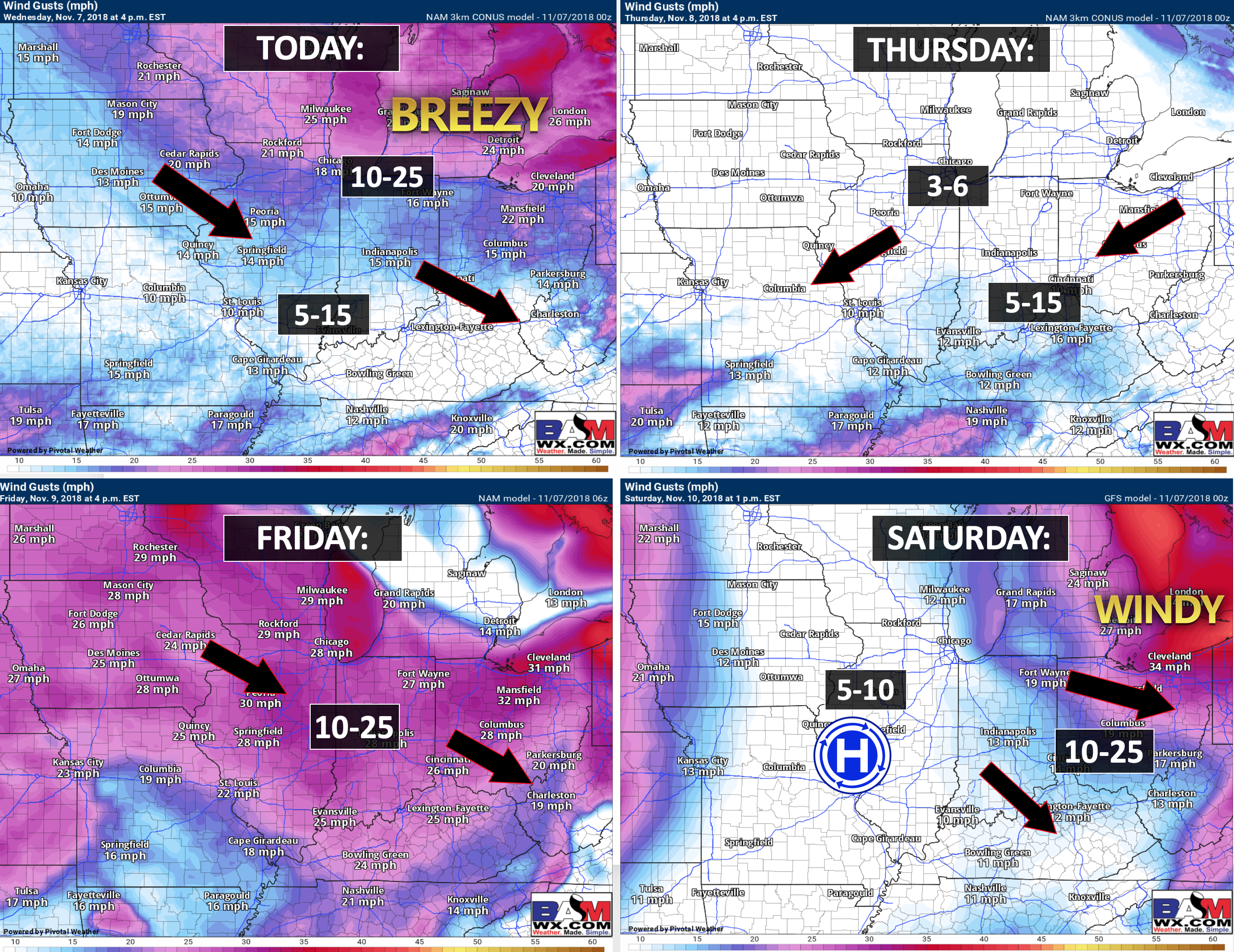
Time to crank up the winter weather graphics. A bit earlier than normal


Wind forecast
The Weather Observatory will be holding an open house for adults and children. Weather permitting, the open house will be Saturday, December 1st.
Learn more about the UV index readings. Click here.

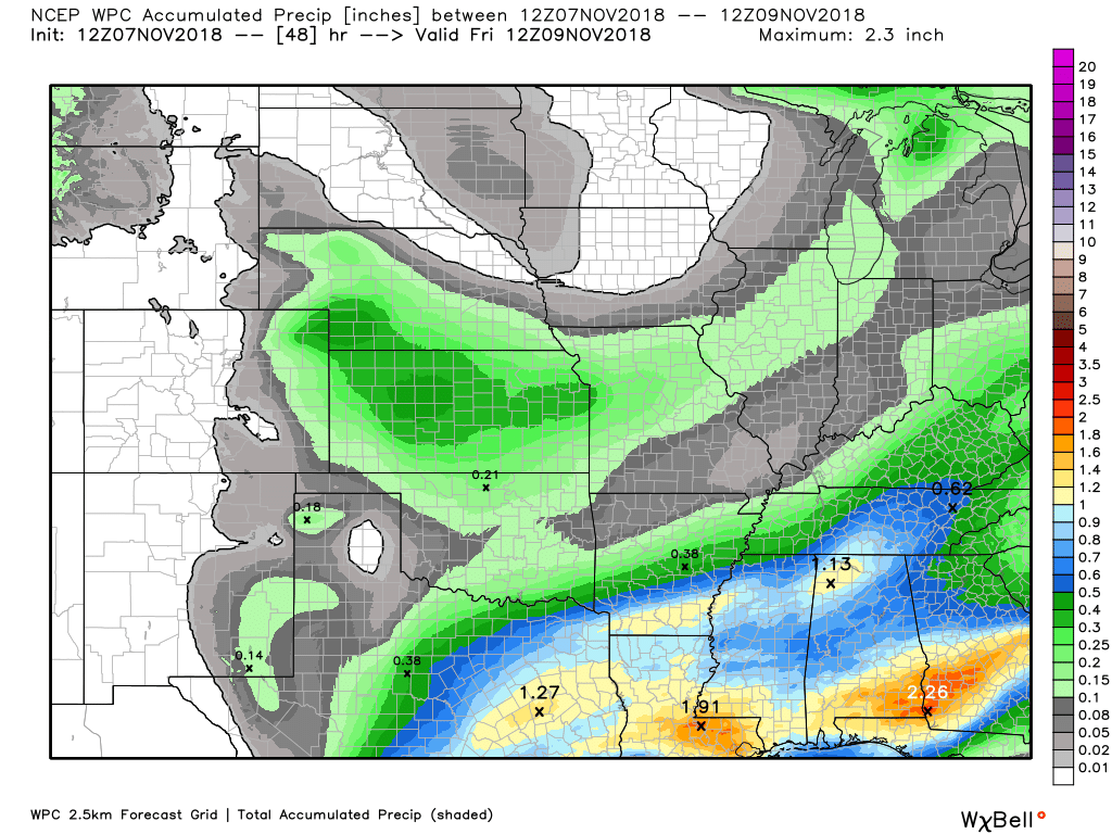
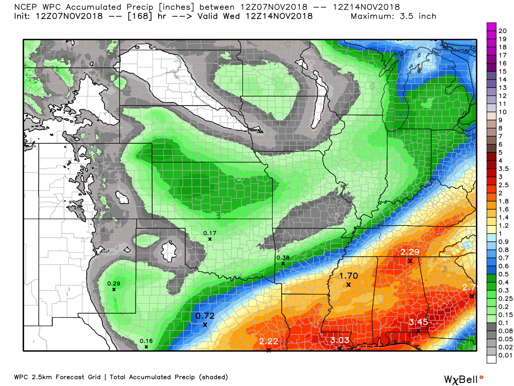
Here is the WPC/NOAA rainfall outlook
Some light showers today won’t amount to much. Trace amounts to perhaps 0.10″ in spots.
Here is the WPC rainfall outlook through Friday morning.
Let’s look at totals through Monday morning. We will have some additional rain chances, especially Thursday night.
Generally, rain totals are forecast to be on the light side. There could be some higher amounts from NW TN into south central KY. Rain totals of 0.20″ to 0.35″ are possible in those areas. Perhaps a bit higher the further southeast you travel.
The WPC rainfall forecast now through Monday covers the potential.
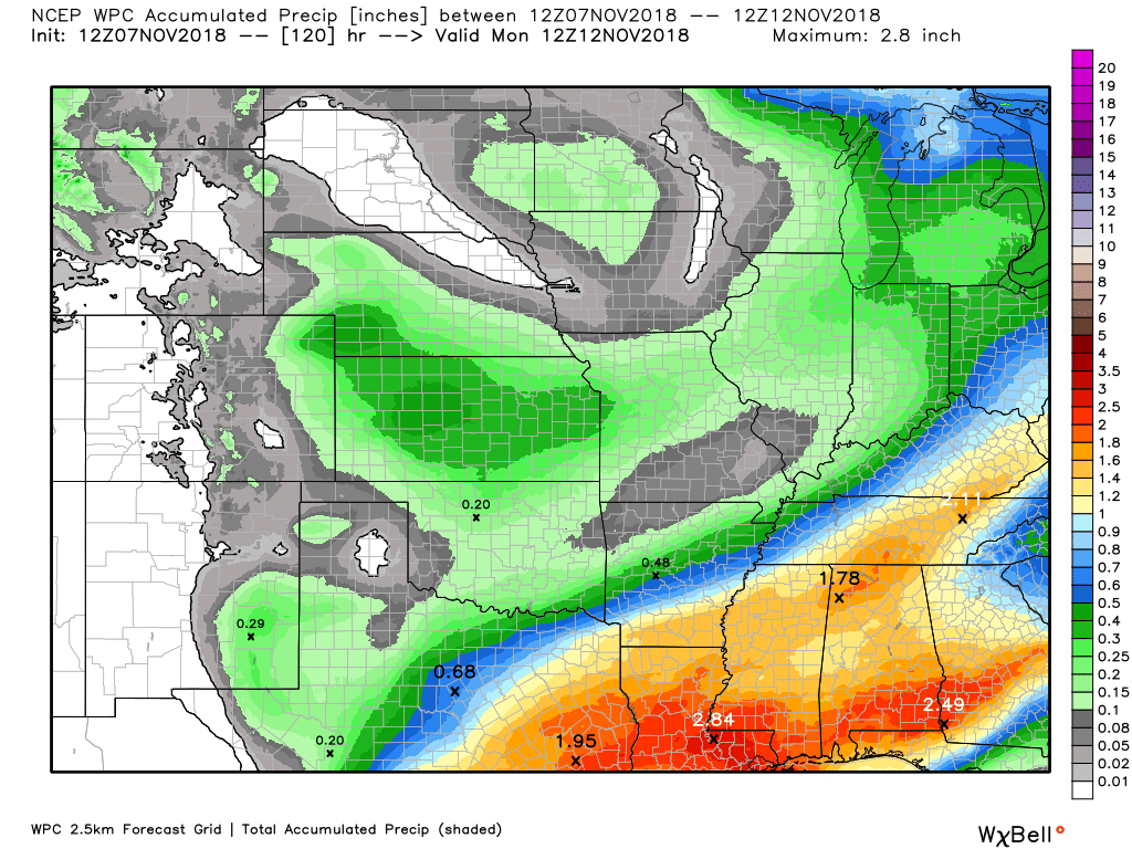
I am monitoring Monday into Wednesday for yet another southern system. That one could bring precipitation into our region, as well. A bit early to know whether we are looking at rain or snow. It could also miss us to the south and east.

Subscribers, do you need a forecast for an outdoor event?


We offer interactive local city live radars and regional radars.
If a radar does not update then try another one. If a radar does not appear to be refreshing then hit Ctrl F5 on your keyboard.
You may also try restarting your browser. The local city view radars also have clickable warnings.
During the winter months, you can track snow and ice by clicking the winterize button on the local city view interactive radars.

Questions? Broken links? Other questions?
You may email me at beaudodson@usawx.com

The National Weather Service defines a severe thunderstorm as one that produces quarter size hail or larger, 58 mph winds or greater, and/or a tornado.
Today through Tuesday: No severe storms.
Interactive live weather radar page. Choose the city nearest your location. If one of the cities does not work then try a nearby one. Click here.
National map of weather watches and warnings. Click here.
Storm Prediction Center. Click here.
Weather Prediction Center. Click here.

Live lightning data: Click here.

Interactive GOES R satellite. Track clouds. Click here.

Here are the latest local river stage forecast numbers Click Here.
Here are the latest lake stage forecast numbers for Kentucky Lake and Lake Barkley Click Here.

- Light showers today (for some)
- Another chance of rain Thursday and mainly Thursday night
- A winters chill is on the way
- Monitoring next weeks snow potential
The NWS has confirmed several tornadoes in Tennessee from the Monday night severe weather event.
At least one person was killed.
New Channel 5 has some photos of the storm damage. Click here.
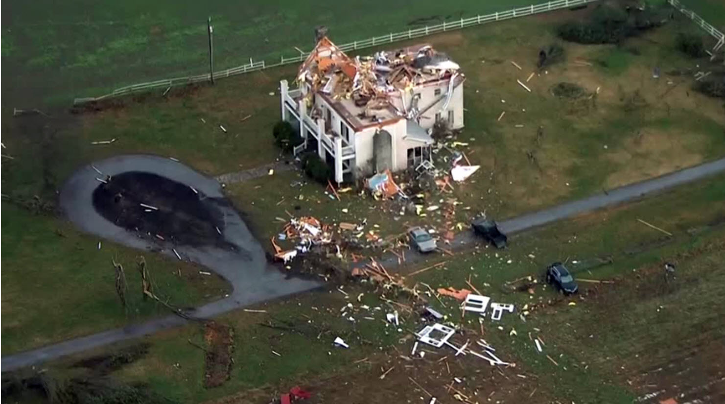
Additional information on those tornadoes. Click here.
Today
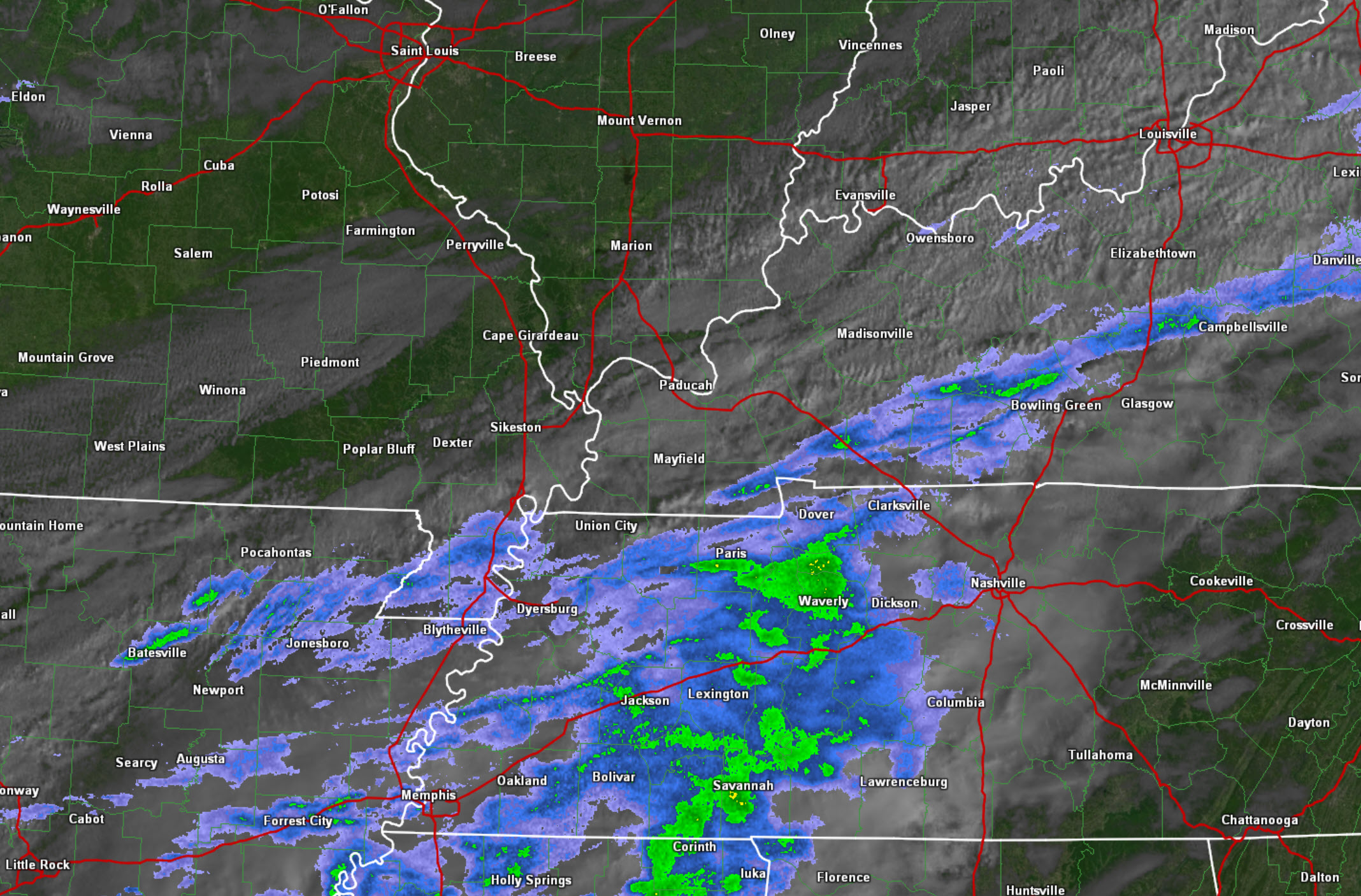
We have some clouds in the region this morning. We also have areas of clear sky. A few light showers dot radar. Most of the showers are from the Missouri Bootheel into western Kentucky and northwest Tennessee. Light, nothing significant.
Here is the 8 AM satellite and radar map. You can see the areas of blue and green. Light showers. This is moving off to the northeast. Much of the region will remain dry today.
Visit our radar page here
It will be a cool day temperature wise. Highs will be in the 50’s.
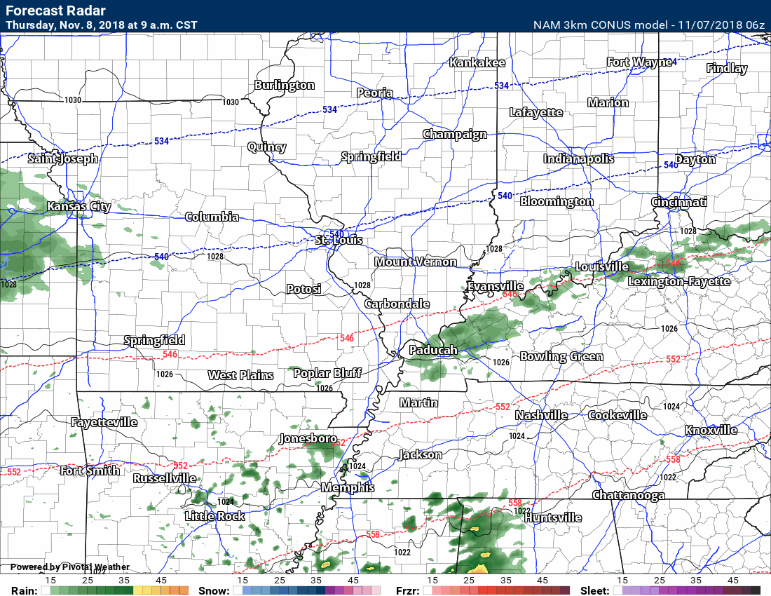
Thursday into Thursday night
Another system will push into the region Thursday and Thursday night. This will deliver another chance of light rain showers. The best chance of rain will be on Thursday night. There will be a chance of snow to our north. It appears the snow chances may brush our northern counties, but for the most part will stay out of my forecast counties. If you are traveling to the north, you should monitor updated forecasts.
Here is the high-resolution NAM 3K model. This shows you areas of precipitation. Green is rain. Yellow is rain. Blue is snow. Purple is ice.
The time-stamp is located in the upper left portion of the graphic.
That rain will push off to the east by Friday. That will leave us with falling temperatures and well below normal temperatures.
A winter chill is on the way.
Here is the temperature animation that shows you Friday into Saturday. Double brrr is all I can say. These are winter temperatures.
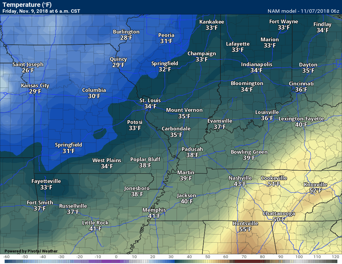
Normal high temperatures in the middle of January are around 43 to 46 degrees. Normal low temperatures are in the middle 20’s. We are going to be near those values Friday and Friday night into Monday.
This is a sharp cold-snap for the region.
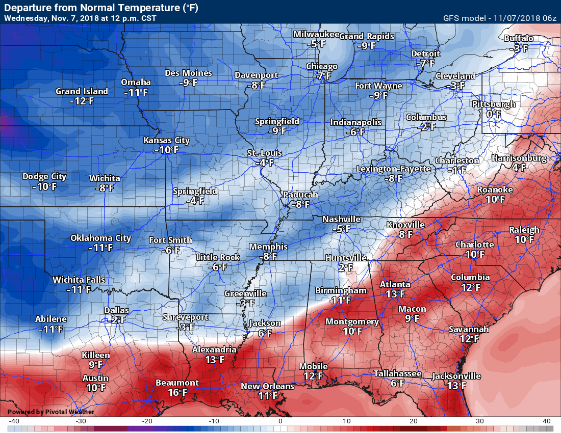
It appears the warm is going to lose out in the coming days!

Let’s look at temperature anomalies. How many degrees above or below normal will temperatures be?
Not only will this be a sharp cold snap, but it will also be a long-lived cold snap. We are going to experience below normal temperatures into next week.
Normal highs are in the middle 60’s and normal lows are in the lower to middle 40’s. We are going to be WELL below those numbers over the coming days.
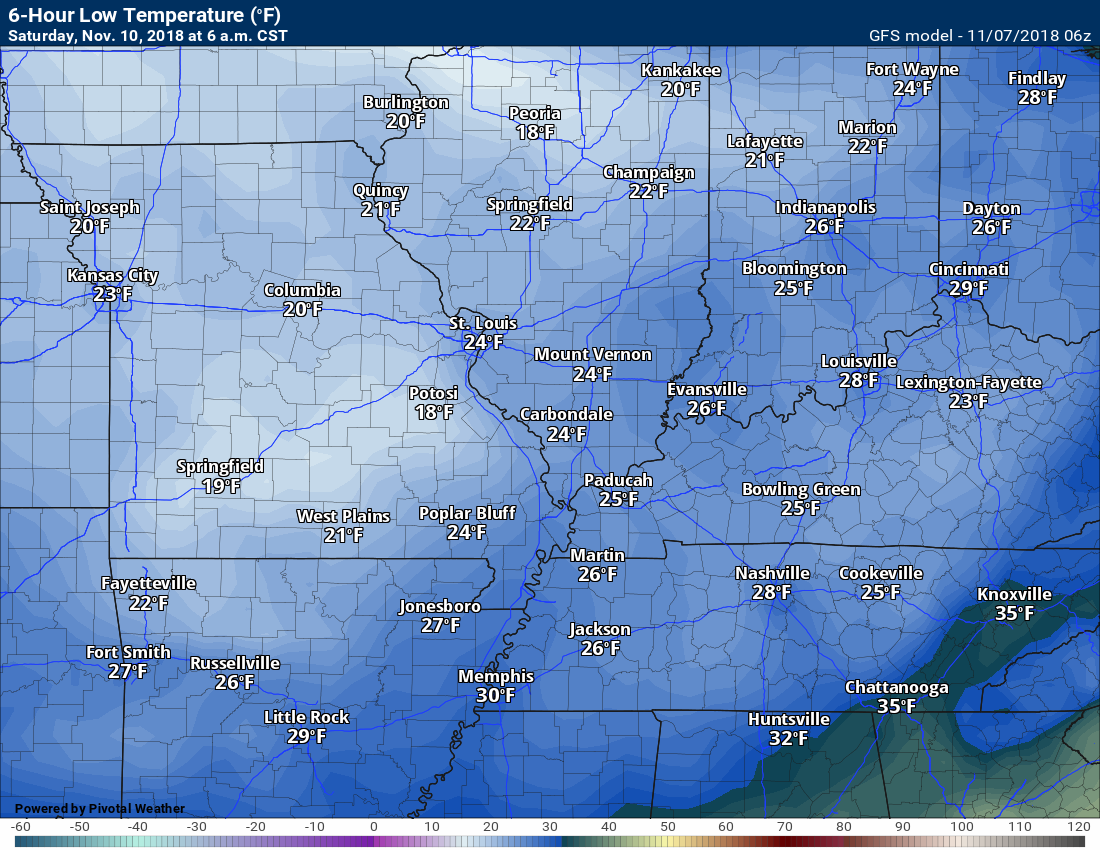
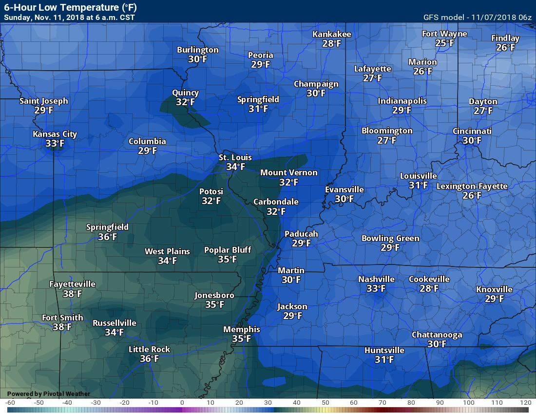
Here are the low temperatures for Saturday morning.
Sunday morning
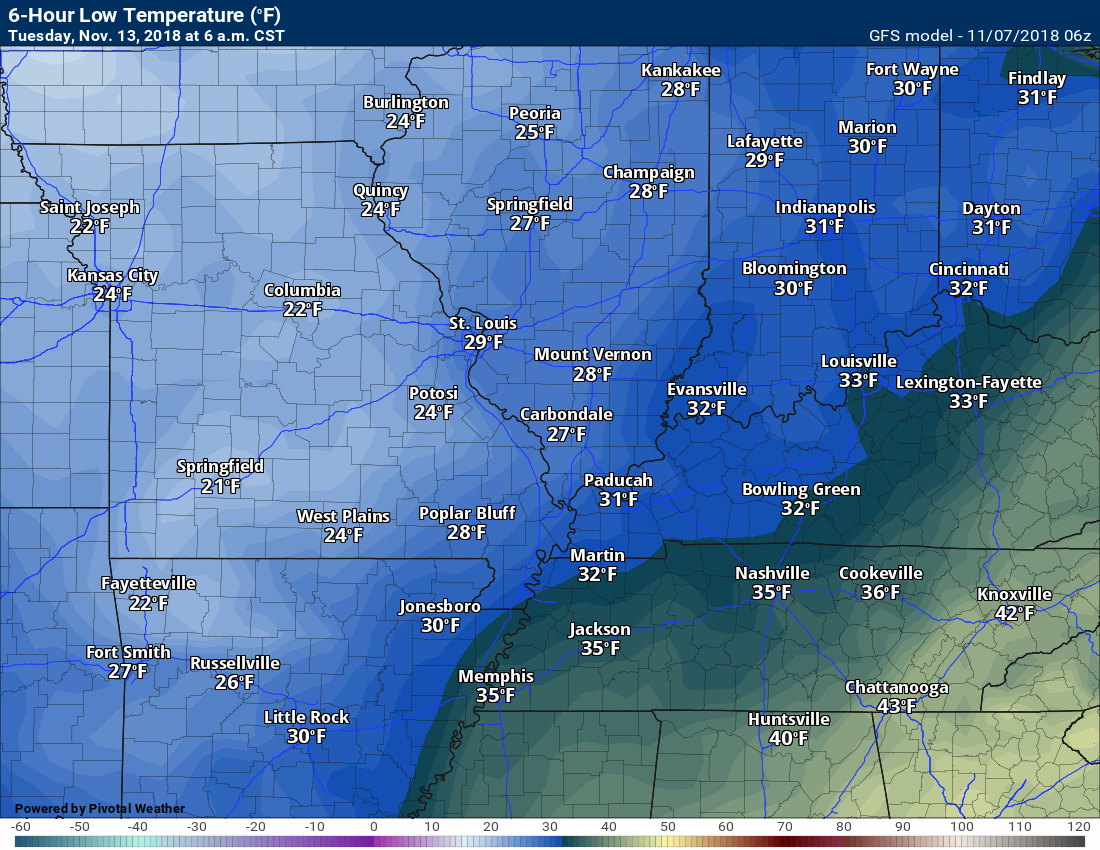
Monday morning
Monday/Tuesday precipitation event.
Winter weather?
Updated November outlook for subscribers!
![]()

I bring these to you from the BAMwx team. They are excellent long-range forecasters.
Remember, long-range outlooks are a bit of skill, understanding weather patterns, and luck combined. It is not an exact science.

This product is for subscribers.
Subscribe at www.weathertalk.com
Subscriber graphics can be viewed on this page CLICK HERE

This product is for subscribers.

This product is for subscribers.
Subscribe at www.weathertalk.com
Subscriber graphics can be viewed on this page CLICK HERE
![]()
.
Fall Outlook!
These products are for subscribers.
November temperature and precipitation outlook
November temperature outlook
November precipitation outlook
.These products are for subscribers.
![]()

A new weather podcast is now available! Weather Geeks (which you might remember is on The Weather Channel each Sunday)
To learn more visit their website. Click here.
![]()

WeatherBrains Episode 666
This week’s Guest WeatherBrain is a world-renowned meteorologist, prognosticator, and extended outlook specialist. A 1978 graduate of Penn State University with a Bachelor of Science in Meteorology and former Nittany Lion Wrestler, he worked at AccuWeather soon after graduation. He currently works for WeatherBELL Analytics as co-Chief Forecaster. Joe Bastardi, welcome to WeatherBrains!
Other discussions in this weekly podcast include topics like:
Other discussions in this weekly podcast include topics like:
Hurricane Willa approaches the Mexican coast
Winter weather outlook from the panel
Astronomy Outlook with Tony Rice
and more!
Link to their website https://weatherbrains.com/
Previous episodes can be viewed by clicking here.

We offer interactive local city live radars and regional radars. If a radar does not update then try another one. If a radar does not appear to be refreshing then hit Ctrl F5. You may also try restarting your browser.
The local city view radars also have clickable warnings.
During the winter months, you can track snow and ice by clicking the winterize button on the local city view interactive radars.
You may email me at beaudodson@usawx.com
Find me on Facebook!

Find me on Twitter!

Did you know that a portion of your monthly subscription helps support local charity projects?
You can learn more about those projects by visiting the Shadow Angel Foundation website and the Beau Dodson News website.

I encourage subscribers to use the app vs regular text messaging. We have found text messaging to be delayed during severe weather. The app typically will receive the messages instantly. I recommend people have three to four methods of receiving their severe weather information.
Remember, my app and text alerts are hand typed and not computer generated. You are being given personal attention during significant weather events.
