
November 7, 2014: This forecast update covers far southern Illinois, far southeast Missouri, and far western Kentucky. See the coverage map on the right side of the blog.
Friday – Mostly sunny sky conditions. Below normal temperatures. Highs will only top out in the lower 50’s. North winds at 5 mph during the morning hours. Winds will shift to the west/southwest during the afternoon with speeds of 5-10 mph.
Morning School Bus Stop Weather – Mostly sunny. Temperatures will be around 34 degrees. North winds at 5-10 mph.
Afternoon School Bus Stop Weather – Mostly sunny sky conditions. Temperatures around 50 degrees. West winds at 10 mph.
Friday Night – Mostly clear. Cool. Low temperatures will be in the upper 30’s. South winds at 5-10 mph
Saturday – Partly cloudy. A small chance for a sprinkle. Cool temperatures. High temperatures around 54 degrees. Southwest winds at 5-15 – winds may switch to the northwest after 12 pm.
Saturday Night – A few clouds. Cooler. Lows in the middle 30’s. Northwest winds at 10 mph.
Sunday – Partly cloudy with below normal temperatures. High temperatures in the middle 50’s. South winds at 10 mph.

An explanation of what is happening in the atmosphere over the coming days.
A cold front pushes through the area on Thursday afternoon and evening. Did you notice the dark clouds? That was associated with the front. An area of low pressure pushed through the Great Lakes. This area of low pressure was responsible for our gusty winds yesterday. Some places recorded wind gusts above 35 mph. I guess you lost a few of those fall leaves?
Today will be a bit more calm in the wind department. A few clouds around. Highs will reach into the 50’s. Not too bad. Those 50’s are still several degrees below normal.
Friday night and Saturday will bring another cold front to the area. There is a small chance for a sprinkle or light shower with the front. Right now it appears that the chances are small. Perhaps the best chance would be over southern Illinois and southwest Indiana. Either way, this is forecast to be a light event (if it rains at all).
Temperatures will warm up a bit on Monday. Expect highs in the 60’s. Don’t get used to those 60’s, because they won’t last long! The coldest air of the season, thus far, will arrive by Wednesday and Thursday. Highs will struggle to get out of the 30’s during that time period. Overnight lows will be well down into the 20’s. I can’t rule out some upper teens, as well. BRRRR for the middle of November.


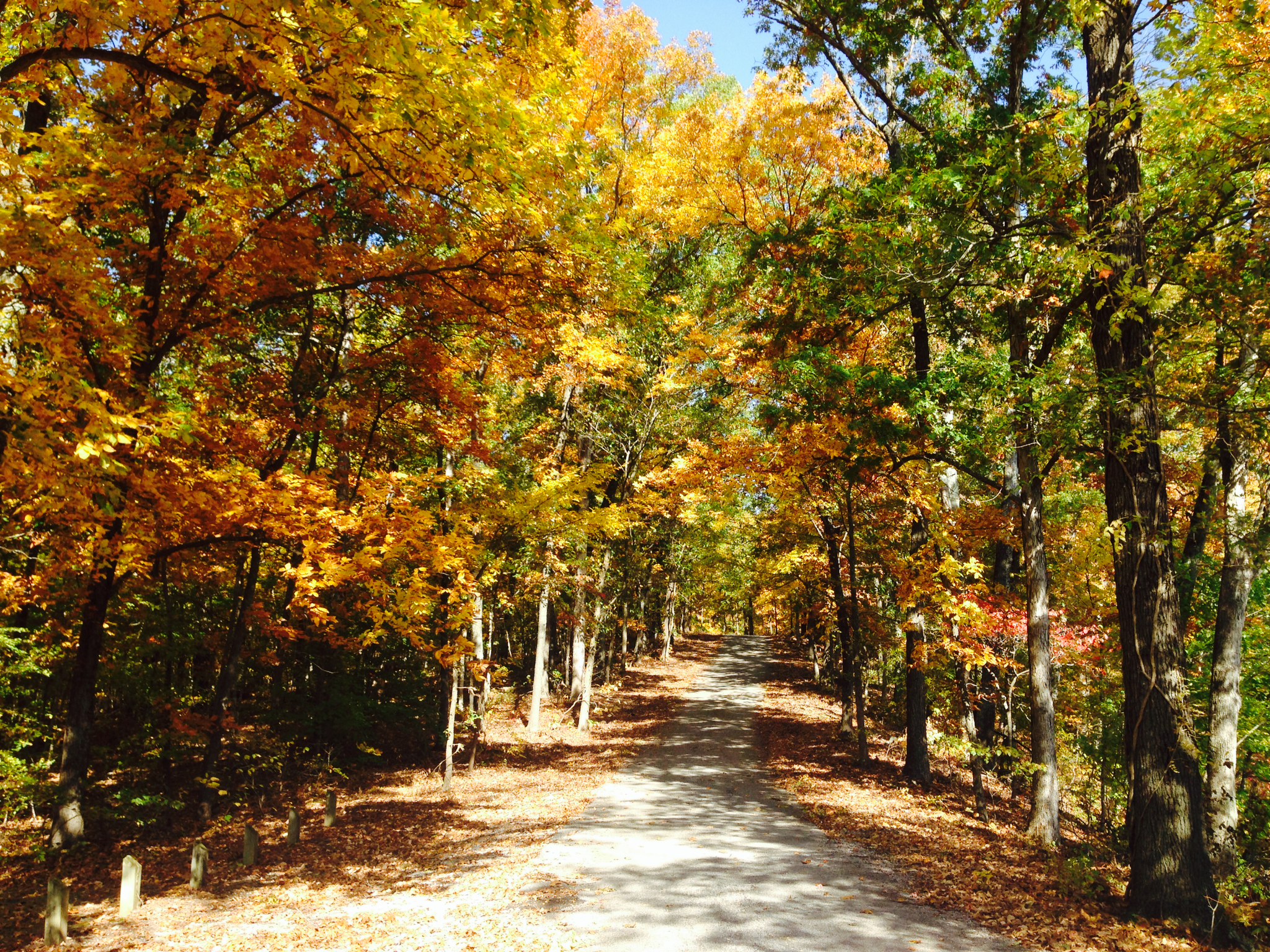
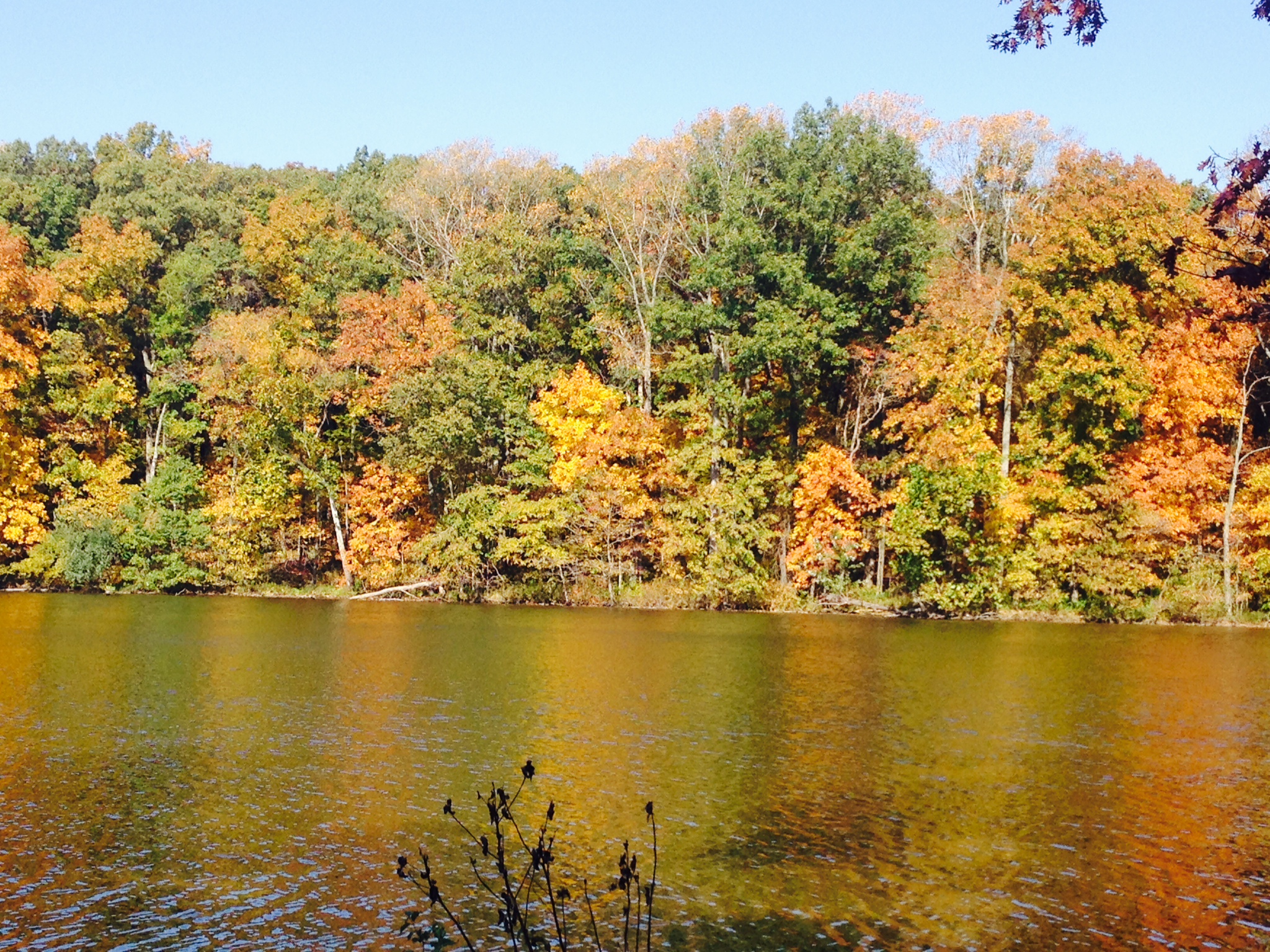
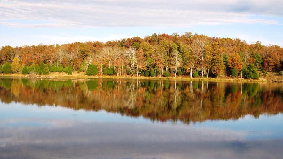
Some photographs sent in to me on Thursday. Fall is in the air!
Email me your photos and I will try to post a few. I can’t post them all. Thanks!
beaudodson@usawx.com
These first two were sent in by Nancy Spear. Giant City State Park (Illinois)

This next photograph was sent in by James Parker – Duncan Lake near LBL (Kentucky)

No significant changes to the ongoing forecast.

No major concerns through Sunday.

The Wild Card gives you an idea of what might change that would cause the forecast to bust. A busted forecast means a forecast that does not verify. For example, if a winter storm (the area of low pressure) shifts its track 50 miles further south than expected, then that could cause a dramatic change in how much snow might or might not accumulate.
Wild card in this forecast will be the possibility of a few sprinkles or light showers on Saturday. This would mainly be over southern Illinois and southwest Indiana. Chances, overall, appear low.

Can we expect severe thunderstorms over the next 24 to 48 hours? Remember that a severe thunderstorm is defined as a thunderstorm that produces 58 mph winds or higher, quarter size hail or larger, and/or a tornado.
Severe weather is not going to be a concern through Sunday.
Thunderstorm threat level is zero.


Live Lightning Data – zoom and pan: Click here
Live Lightning Data with sound (click the sound button on the left side of the page): Click here

Will I need to take action?
No. Calm weather is forecast through Sunday. Small chance for a shower on Saturday.

Please visit your local National Weather Service Office by clicking here. The National Weather Service Office, for our region, is located in Paducah, Kentucky.
![]()
We have regional radars and local city radars – if a radar does not seem to be updating then try another one. Occasional browsers need their cache cleared. You may also try restarting your browser. That usually fixes the problem. Occasionally we do have a radar go down. That is why I have duplicates. Thus, if one fails then try another one.
If you have any problems then please send me an email beaudodson@usawx.com
WEATHER RADAR PAGE – Click here —
We also have a new national interactive radar – you can view that radar by clicking here.
Local interactive city radars include St Louis, Mt Vernon, Evansville, Poplar Bluff, Cape Girardeau, Marion, Paducah, Hopkinsville, Memphis, Nashville, Dyersburg, and all of eastern Kentucky – these are interactive radars. Local city radars – click here

Regional Radar – Click on radar to take you our full radar page.


Regional Radar

Current WARNINGS (a warning means take action now). Click on your county to drill down to the latest warning information. Keep in mind that there can be a 2-3 minute delay in the updated warning information.
I strongly encourage you to use a NOAA Weather Radio or warning cell phone app for the most up to date warning information. Nothing is faster than a NOAA weather radio.


Missouri Warnings

Illinois Warnings

Kentucky Warnings
I have added a lot of new maps to the Southern Illinois Weather Observatory web-site. Check them out by clicking here.

No winter weather concerns through Sunday.

Short and brief today 🙂
There is the potential for a larger storm system the week of Thanksgiving (16th-22nd). LONG way off for details. This would connect with what is happening out in the Pacific Ocean. I have been watching the potential for about a week now – for that time frame. So, if you like “shot in the dark” extended forecasts, then that one is for you.
Now for a more realistic time frame in the extended period…
The big weather story in the extended forecast is going to be cold temperatures. Monday and Tuesday will see a brief warm up (ahead of our next storm system). We may also see a chance for a few showers ahead of the cold front early next week. I don’t believe there will be enough moisture available for any significant precipitation.
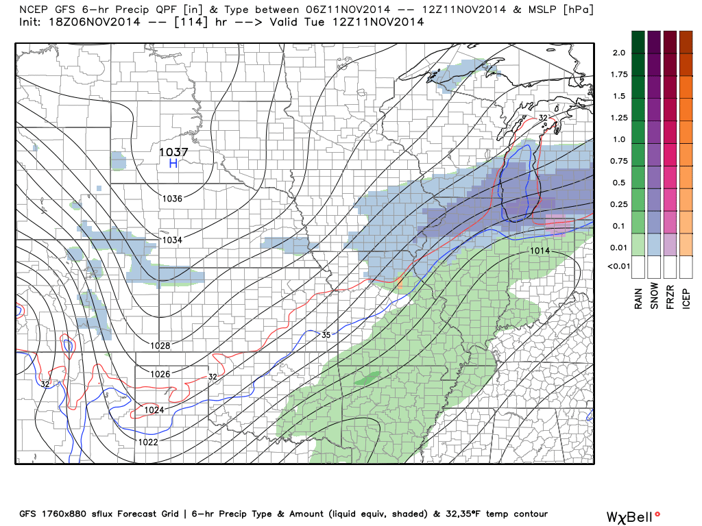
Here is the weather map for Tuesday morning – note the green color represents a few showers over our region. The blue over northern Illinois represents some light snow. That thin red line moving through Missouri is the 32 degree line.
Precipitation should end before the colder air moves into our local counties. This will keep the precipitation all rain.
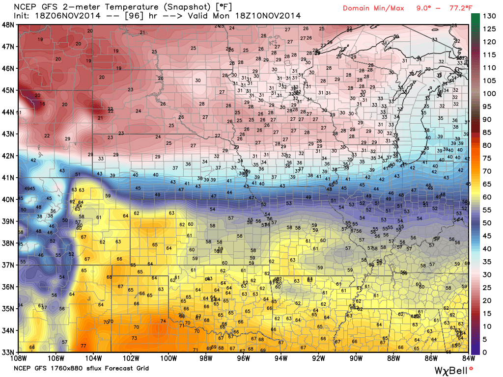
Note the temperatures on Monday afternoon will warm up ahead of the cold front. Here is the temperature forecast map. You can see the cold air spilling into the Missouri Valley from the Northern Plains.
The freezer door is left open by Wednesday and Thursday. High temperatures may struggle to get out of the 30’s. Overnight lows in the upper teens and lower 20’s seem a good bet. Tough call on specific low temperatures this far out. We may end up mostly in the 20’s. Whether we see some upper teens is still in question.
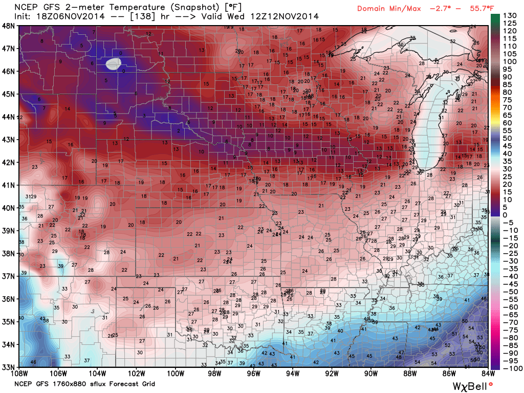
Here is the GFS (computer model) temperature map for Wednesday morning. Cold air has made quite a bit of headway by that time.
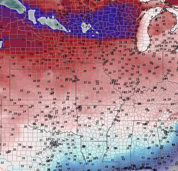
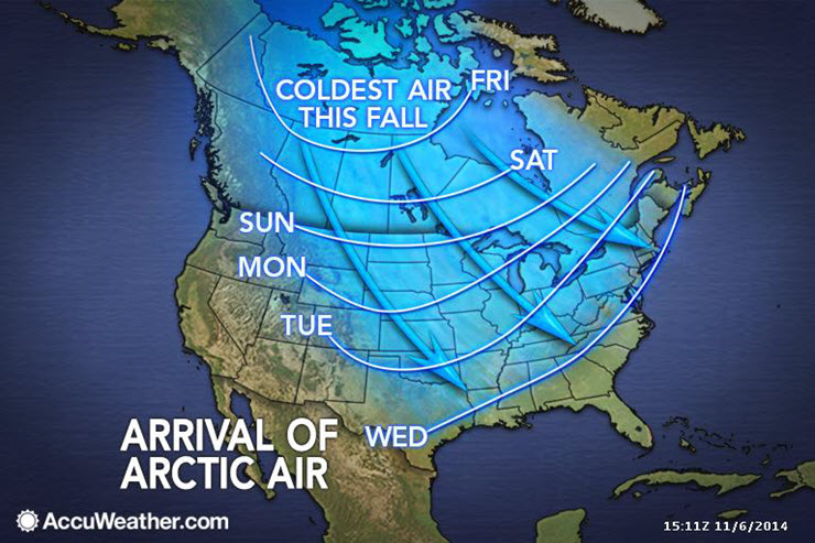
Check out how far south the 30’s are by Thursday morning. All the way into Louisiana! Impressive cold surge for this early in November.
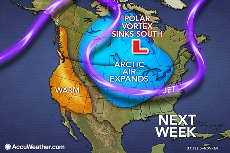
Blast of Cold Air
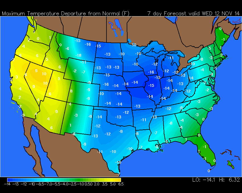
Temperatures will likely be 10-15 degrees below normal next Wednesday.
Normal highs this time of the year are in the 60’s. Normal lows are in the 40’s.
Here is the map showing you the large chunk of the nation that is forecast to experience below normal readings. The numbers represent how many degrees below normal temperatures will likely be (those numbers don’t represent actual temperatures).
Right now I am not tracking any winter precipitation makers for next week. I will continue to monitor. Occasionally we see a few flurries with a cold outbreak of this nature.
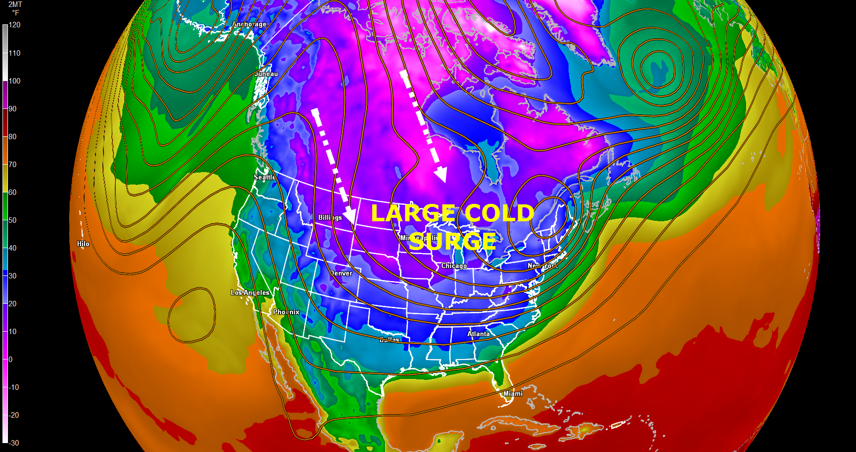
Here is a 500mb height map and temperature map for next Thursday. Just look at the wide area covered by cold air. This is quite amazing for the middle of November. Chilly all the way to the Gulf of Mexico.
The colors represent temperatures (scale on the left). The lines are 500 mb heights.
Here is the 6-10 day temperature and precipitation outlook. Be sure and check the dates below the scale.
Remember this map shows you what the PROBABILITY of below or above normal temperatures will be. The deeper the blue color then the greater chance that temperatures will be below normal.


The 8-14 Day Outlook for temperatures and precipitation (see dates above each image)


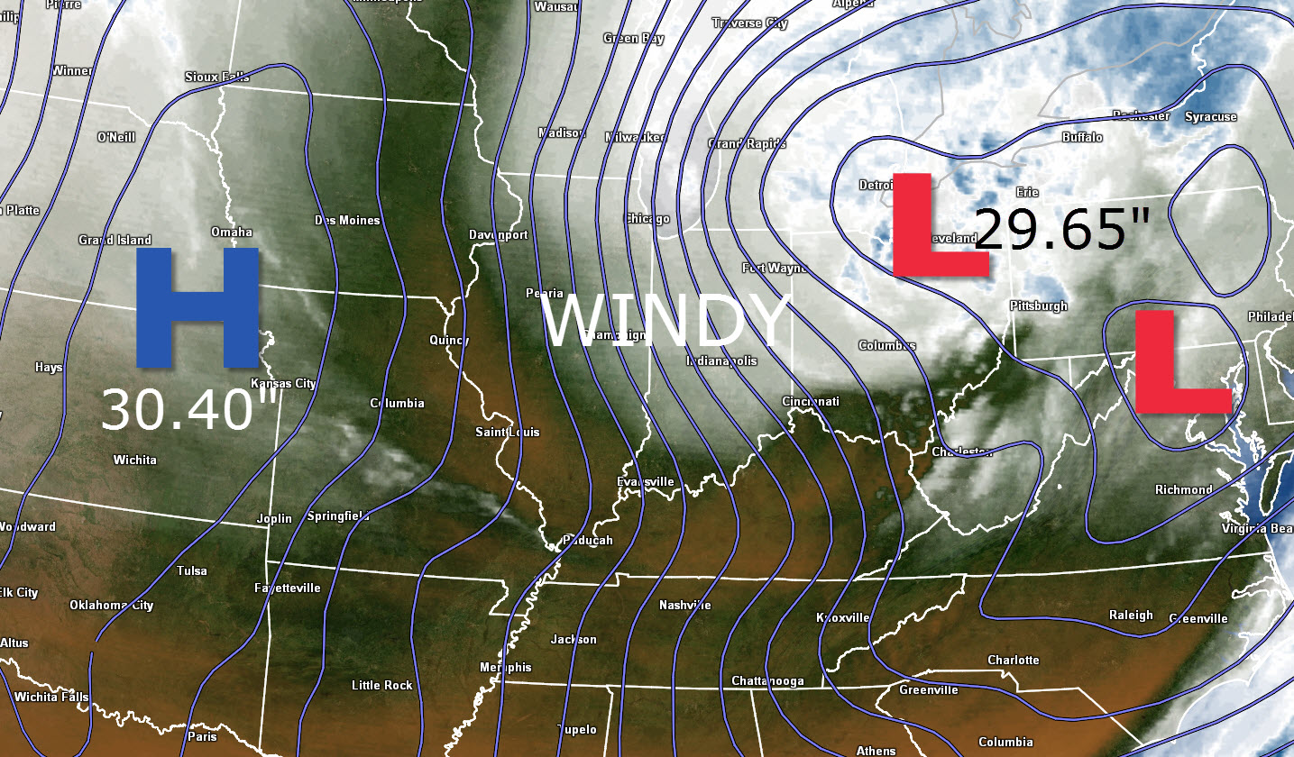
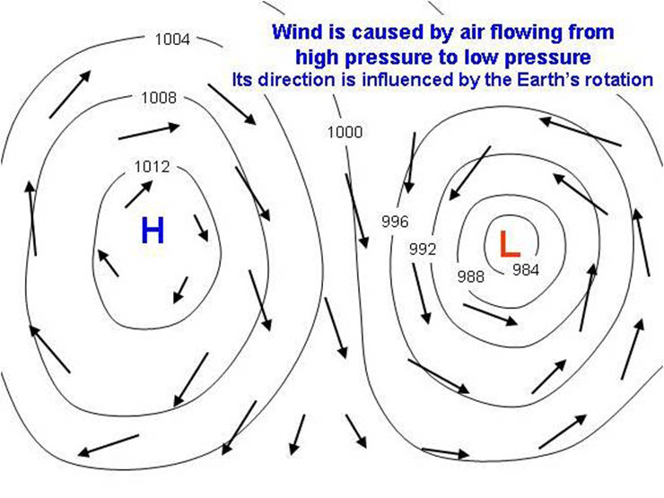
We had some gusty winds on Thursday. That was because of the tight isobars over our region. Here is the weather map from Thursday afternoon. See those lines that are tightly packed over the Ohio Valley? Those are equal lines of barometric pressure. The pressure gradient between the high pressure over Kansas and the low pressure over the Great Lakes created windy conditions for our area.
If you have a barometer in your house then you can read the current pressure reading. Most people have an old barometer hanging on the wall. A normal pressure reading in our region would be around 30.00″.
Note on Thursday that the pressure reading was 30.40″ over Kansas. The area of low pressure (over the Great Lakes) had a pressure reading of 29.65″. That is a decent pressure spread from one point to the other. Imagine low pressure as being a vacuum.
Imagine high pressure as having excess air and low pressure systems having less air. The air will move from higher towards lower pressure. The stronger the pressure gradient (difference between the high and low pressure) the greater the outside wind speeds will be.
Current tower cam view from the Weather Observatory- Click here for all cameras.

Southern Illinois Weather Observatory

The Weather Observatory
WPSD TV 6 has a number of tower cameras. Click here for their tower camera page
& Kentucky Road Conditions & Kentucky Highway and Interstate Cameras

Downtown Paducah, Kentucky
Benton, Kentucky Tower Camera – Click here for full view

Benton, Kentucky
WSIL TV 3 has a number of tower cameras. Click here for their tower camera page
& Illinois Road Conditions

Marion, Illinois

You can sign up for my AWARE email by clicking here I typically send out AWARE emails before severe weather, winter storms, or other active weather situations. I do not email watches or warnings. The emails are a basic “heads up” concerning incoming weather conditions.