

November 5, 2014: This forecast update covers far southern Illinois, far southeast Missouri, and far western Kentucky. See the coverage map on the right side of the blog.
Major forecast changes this morning. Our friendly rain band has moved out of the area quicker than expected.
Wednesday – Mostly cloudy with a chance for a shower – mainly over our far southeast counties. High temperatures will be in the 54-58 degree range. Temperatures may fall during the afternoon. Winds will be mostly from the northeast/east at 5-10 mph. Variable winds this afternoon. Chance of rain 20% – except a bit higher than that over the KY/TN border counties.
Morning School Bus Stop Weather – Mostly cloudy. Small chance for a shower. Temperatures will be around 50 degrees. Northeast winds at 5 mph.
Afternoon School Bus Stop Weather – Mostly cloudy. A few showers along the KY/TN border counties. Temperatures will be in the 55-58 degree range. East winds at 5-10 mph.
Wednesday Night – Decreasing clouds. Cool. Low temperatures will be in the middle 40’s. Southwest winds at 5 mph.
Thursday – Partly cloudy. Windy at times. High temperatures in the 50’s. Temperatures will fall during the afternoon hours. Winds from the northwest at 10-15 mph. Gusty in the afternoon. Some gusts above 25 mph possible.
Thursday Night – A few clouds. Cooler. Lows in the 30’s. Northwest winds at 10-20 mph.
Friday – Partly cloudy and cool. High temperatures in the upper 40’s and lower 50’s.
TRACK THE RAIN TODAY:
We have regional radars and local city radars – if a radar does not seem to be updating then try another one. Occasional browsers need their cache cleared. You may also try restarting your browser. That usually fixes the problem. Occasionally we do have a radar go down. That is why I have duplicates. Thus, if one fails then try another one.

An explanation of what is happening in the atmosphere over the coming days.
A slow moving storm system brought rain to the region on Tuesday and into the overnight hours. Rainfall totals have generally been in the 0.30″-0.70″. A few areas picked up more than 1″ of rain. The least amount of rain fell over portions of far southeast Illinois and western Kentucky. Some places did not pick up more than 0.30″ of precipitation. This is a significant forecast bust compared to what was expected.
This morning, rain is moving out quicker than anticipated. Only a few showers remain in the region (mostly our southeast counties). Thus, major forecast changes today. Instead of an 80% chance of rain we are looking at a 20% chance for remaining showers. The chance for additional rain will be greatest along the KY/TN border counties – chances there will be greater than 20%.
Another slug of moisture will move northeast out of Arkansas later this morning and early afternoon. This may spread rain back into portions of western Kentucky. Greatest chance would again be along the Kentucky/Tennessee border.
Temperatures are going to be below normal right through the weekend and into next week (see the six to ten day outlook further down on this page). If this pattern continues into the winter then we will be facing another cold one (remember how cold last winter was).
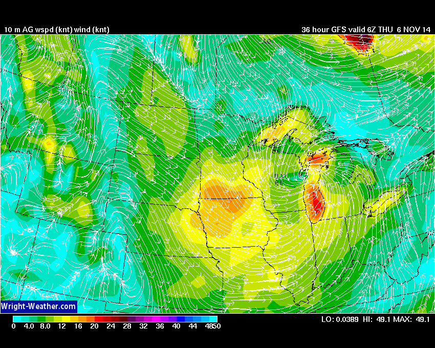
Let me show you some jet stream graphics. This gives you an idea of why we are experiencing temperatures below normal.
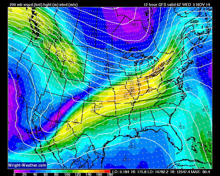
This first map shows you the winds around midnight last night. What do you notice? Notice how the general flow is out of the southwest into our region. The bright colors (wind speed) are streaming out of Mexico and Texas into our region and then northeast into New York. This is the reason moisture is streaming into our region. When you see a jet stream like that you can generally assume we are having active weather. In the winter time this would be a large overrunning event (lots of precipitation).
Now watch what happens to the jet stream in the next couple of images
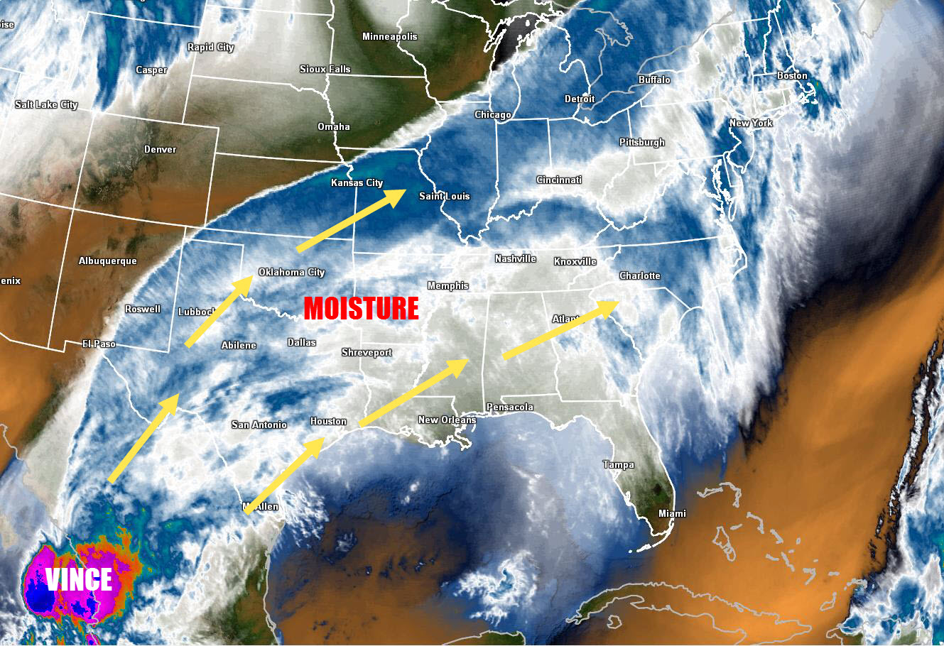
Here is what the satellite image looked like. See how the clouds are all streaming out of the Pacific and Mexico. Those clouds streamed into our region. A band of rain extended from Mexico all the way into Michigan, New York, and Canada.
The white and blue represents moisture and clouds. Note they extended all the way back to Tropical Storm Vince (off the Coast of Mexico). Vince is the bright purple blog at the bottom left of the image.
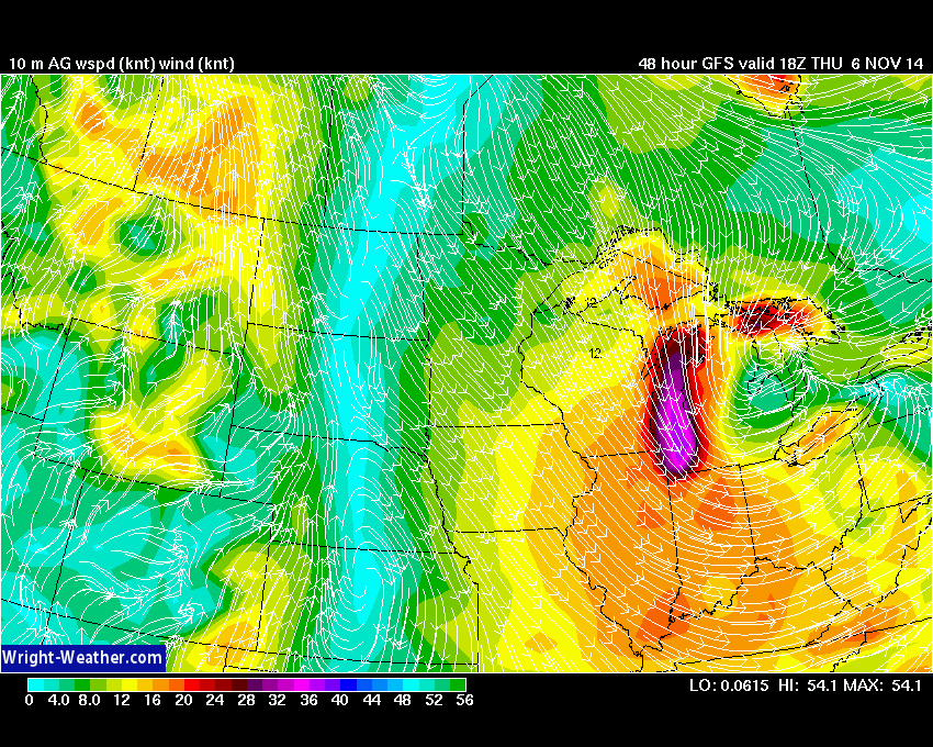
Here is the jet stream map for late Thursday night. What do you notice? Notice that the winds are now diving down from the northwest. The southwest flow is gone. Winds are diving down from Canada. Follow the white lines from Canada down into Illinois – that is what we call northwest flow.
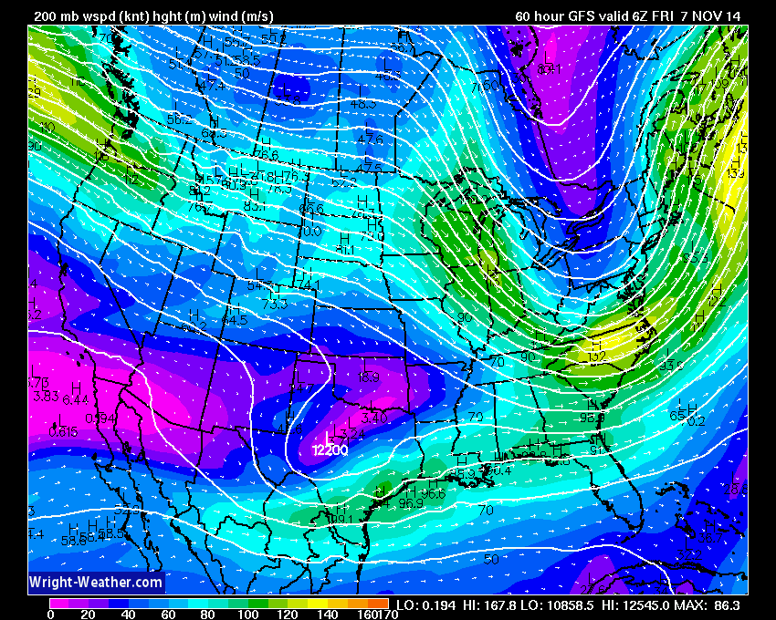
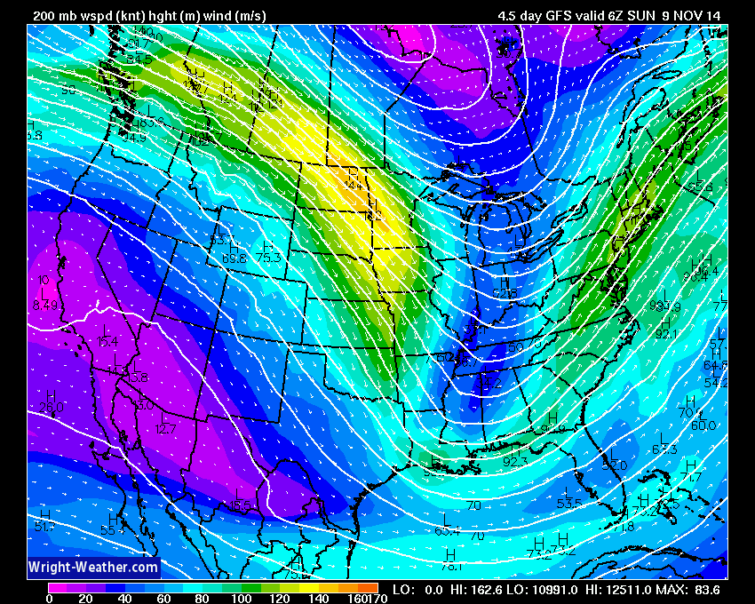
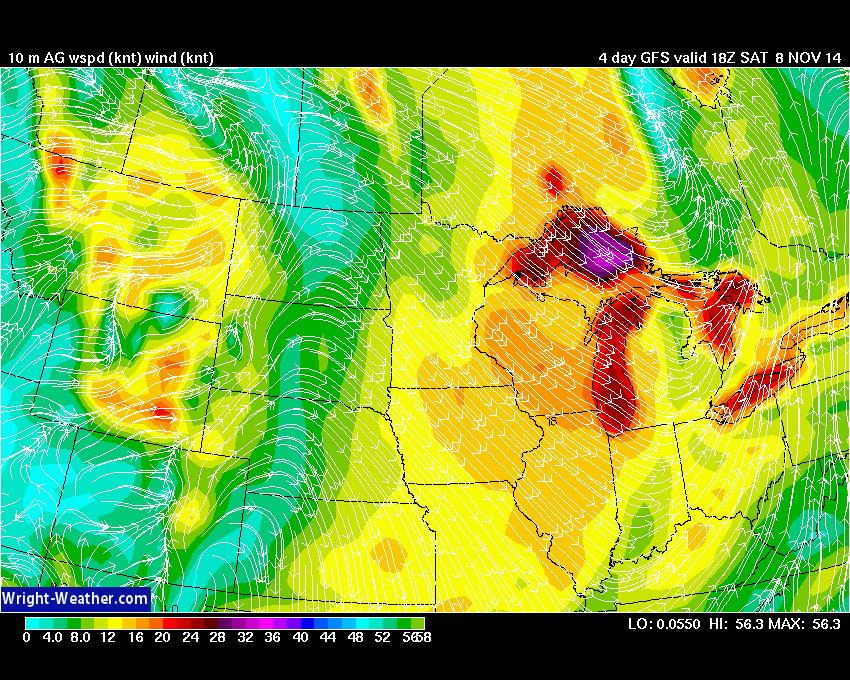
Here is the jet stream map for late Saturday night/Sunday morning. Strong jet stream diving out of Canada into the Missouri and Ohio Valley. The bright yellow and orange colors represent wind speed. Winds speeds above 140 knots at the 200 mb level (way way up in the atmosphere). Strong northwest flow aloft. You can see the jet stream dipping into the Ohio Valley. This is called a trough. When we have a trough that large over the eastern U.S. it typically means below normal temperatures. And, yes – that will be the case over the coming weekend.
In summary – when you see the southwest flow aloft (the first image) you can expect active weather in our region. Lots of overrunning precipitation.
When you see the big dip in the jet stream coming out of Canada then that normally means cold weather. In the winter that type of jet stream can bring clipper systems into the area. These clippers can produce snow. We aren’t that far into the cold season just yet. But, if this pattern were to continue into December then you could expect very cold air and snow.
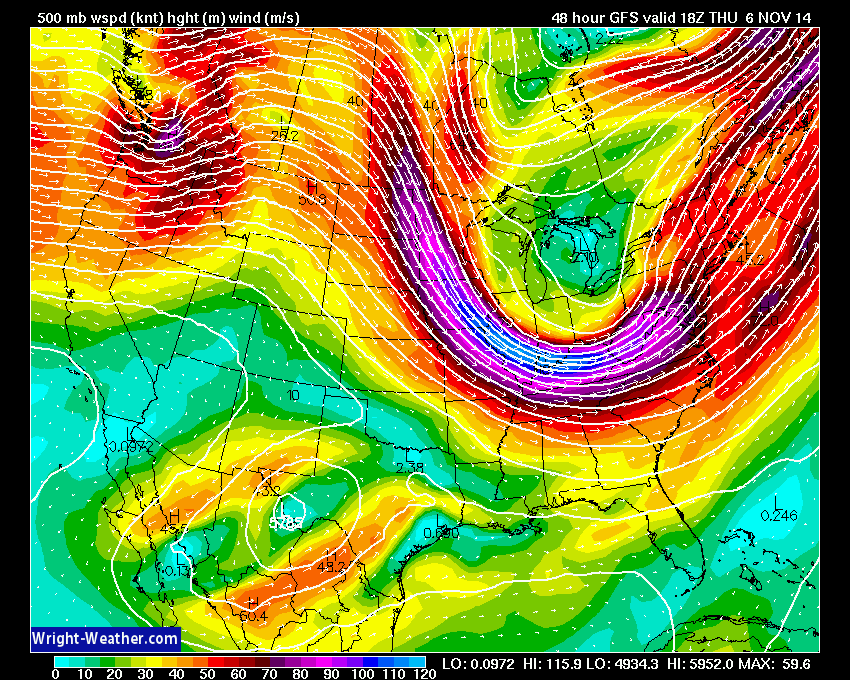
Here is another view of the winds aloft. This map is for Thursday afternoon. Note the very strong wind fields aloft over the Missouri and Ohio Valley. Nice big dip in the jet stream. Clipper coming down out of Canada. Again, when you see these big dips in the jet stream you can expect cooler than normal temperatures.
The colors on this map represent wind speed. The scale is at the bottom of the image. Those bright blue colors over Missouri and Illinois represent 100+ knot winds (aloft – not at the surface, of course).

The dew point map shows you the surge of moisture over portions of our region. Remember, dew points give you an indication of how much moisture is in the air. The higher the dew points the more moisture to work with. Typically dew points surge along and ahead of cold fronts. Dew points usually decrease as you push further behind a frontal system. As drier air moves in (lower dew points) you will see rain come to an end.


A couple of photographs sent to me on the Facebook weather page
These photographs were taken by Jonna Parham Neihoff from Hickory, Kentucky (thanks for sharing)

MAJOR forecast changes this morning. Rain moved out much quicker than anticipated. A bit surprising – especially since all the data pointed towards today being a wet one. In this day and age we don’t see drastic changes like that in the forecast very often. Had this been a winter storm then we would have gone from a winter storm warning to nothing at all!

No major concerns.

The Wild Card gives you an idea of what might change that would cause the forecast to bust. A busted forecast means a forecast that does not verify. For example, if a winter storm (the area of low pressure) shifts its track 50 miles further south than expected, then that could cause a dramatic change in how much snow might or might not accumulate.
Wild card in this forecast – the coverage of additional showers over western Kentucky as another disturbance moves up from Arkansas.

Can we expect severe thunderstorms over the next 24 to 48 hours? Remember that a severe thunderstorm is defined as a thunderstorm that produces 58 mph winds or higher, quarter size hail or larger, and/or a tornado.
Severe weather is not going to be a concern through Friday.
Thunderstorm threat level is zero.


Live Lightning Data – zoom and pan: Click here
Live Lightning Data with sound (click the sound button on the left side of the page): Click here

Please visit your local National Weather Service Office by clicking here. The National Weather Service Office, for our region, is located in Paducah, Kentucky.
![]()
We have regional radars and local city radars – if a radar does not seem to be updating then try another one. Occasional browsers need their cache cleared. You may also try restarting your browser. That usually fixes the problem. Occasionally we do have a radar go down. That is why I have duplicates. Thus, if one fails then try another one.
If you have any problems then please send me an email beaudodson@usawx.com
WEATHER RADAR PAGE – Click here —
We also have a new national interactive radar – you can view that radar by clicking here.
Local interactive city radars include St Louis, Mt Vernon, Evansville, Poplar Bluff, Cape Girardeau, Marion, Paducah, Hopkinsville, Memphis, Nashville, Dyersburg, and all of eastern Kentucky – these are interactive radars. Local city radars – click here

Regional Radar – Click on radar to take you our full radar page.


Regional Radar
I have added a lot of new maps to the Southern Illinois Weather Observatory web-site. Check them out by clicking here.

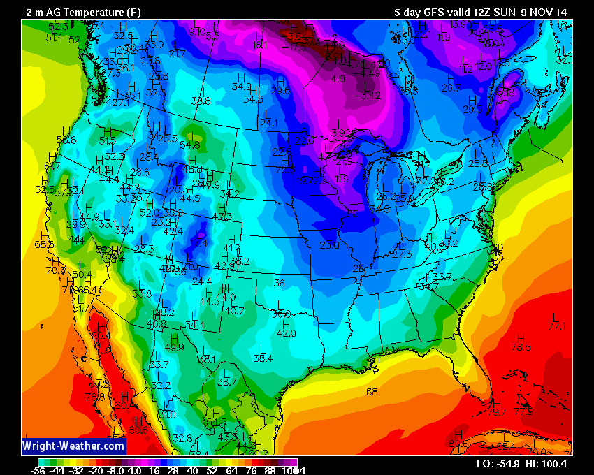
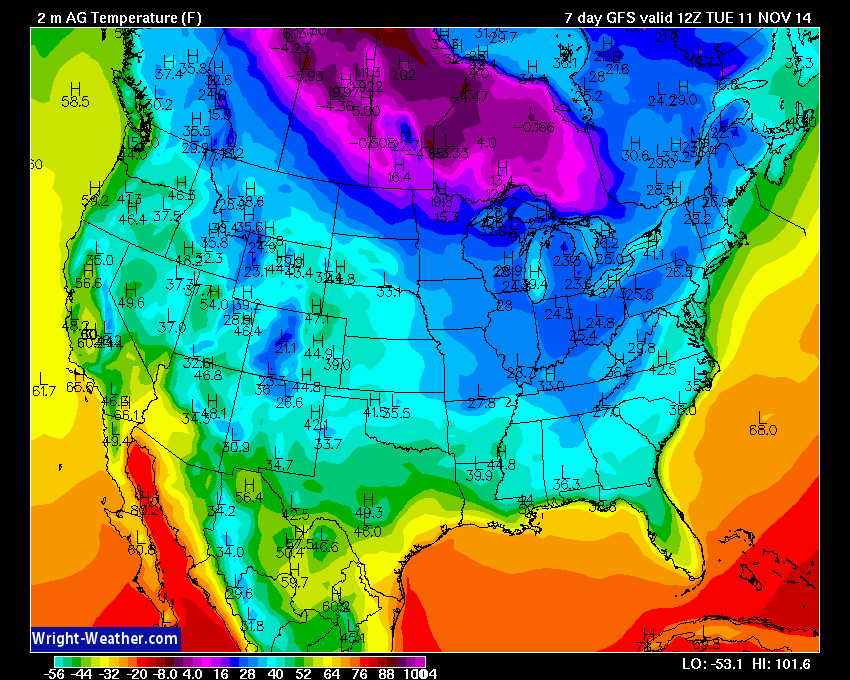
A lot of cool air is coming down the pike over the next 7-14 days. Below normal temperatures will likely be the rule.
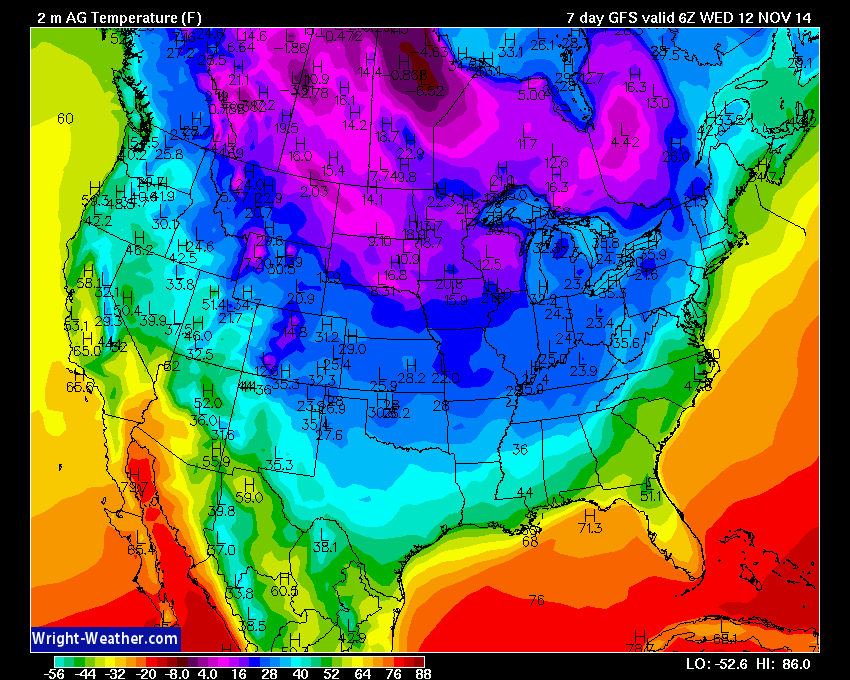
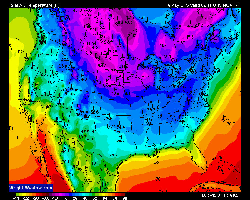
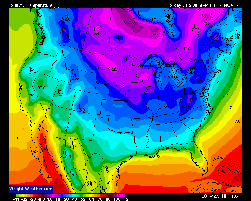
Check out these temperatures on the GFS model for next week. This is a big blast of cold air for so early in the season.
Tuesday night
Wednesday night temperatures
Thursday night temperatures
Friday night temperatures
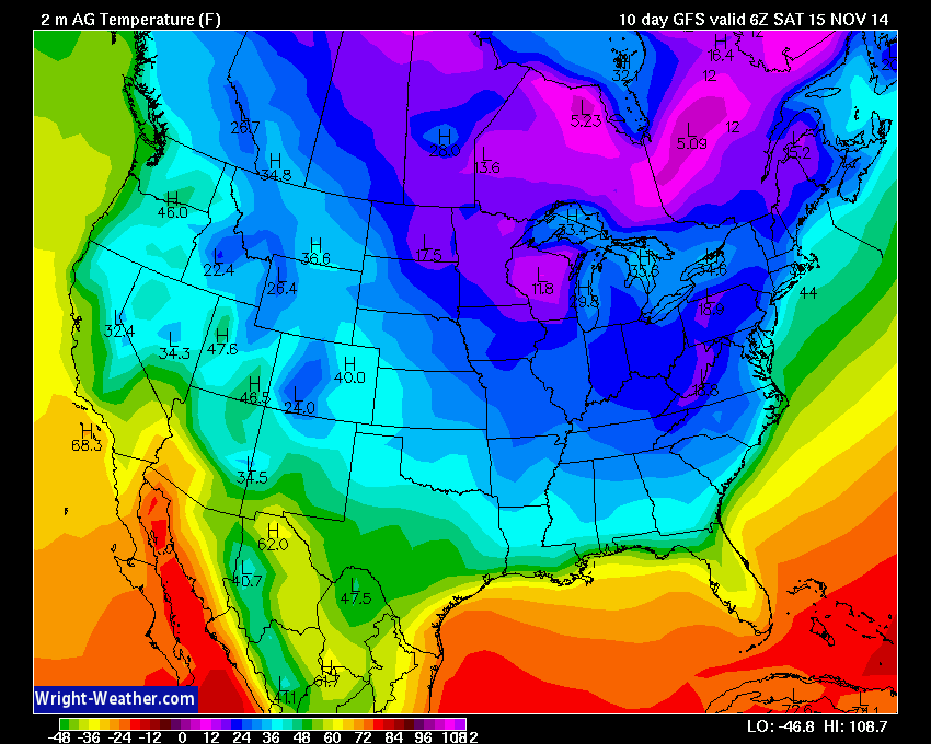
Folks, if that ends up verifying then that would be some impressive cold weather for this time of the year.
I am monitoring a clipper system that will push down out of Canada on Thursday. This will bring an increase in clouds over our region Wednesday night into Thursday night. Winds will pick up from the northwest, as well. Gusty winds are likely on Thursday.
Let’s take a look at the wind forecast maps for late Wednesday night. Notice as the system pulls out of Canada that the bright colors are increasing over the Missouri and Ohio Valley. The colors represent wind speed. Nothing major, but an increase. The yellow colors represent 10-15 mph winds. This is for the 11 pm through 1 am time frame Wednesday night/Thursday morning.
Now let’s move forward into the afternoon hours on Thursday. Note the colors brighten even more. This means winds will be increasing through the day on Thursday. Winds will gust over 20-25 mph. Fall winds.
Another system will produce gusty winds on Saturday. Note the winds are from the northwest. Cool winds. Cool weekend.
Speaking of cool/cold temperatures. Here are the forecast temperatures for Sunday morning. We may see lows in the 20’s once again.
The cool/cold weather should stick around for awhile. Here are the mornings low for Tuesday morning.


And the 8-14 temperature outlook. Does this look familiar to anyone? This is the same pattern we saw last winter. Last winter was a bitterly cold one for much of the Ohio Valley. Lot of snow, sleet, and ice events, as well.

Current tower cam view from the Weather Observatory- Click here for all cameras.

Southern Illinois Weather Observatory

Weather Observatory
WPSD TV 6 has a number of tower cameras. Click here for their tower camera page
& Kentucky Road Conditions & Kentucky Highway and Interstate Cameras

Downtown Paducah, Kentucky
Benton, Kentucky Tower Camera – Click here for full view

Benton, Kentucky
WSIL TV 3 has a number of tower cameras. Click here for their tower camera page
& Illinois Road Conditions

Marion, Illinois

You can sign up for my AWARE email by clicking here I typically send out AWARE emails before severe weather, winter storms, or other active weather situations. I do not email watches or warnings. The emails are a basic “heads up” concerning incoming weather conditions.