We have some great sponsors for the Weather Talk Blog. Please let our sponsors know that you appreciate their support for the Weather Talk Blog.
Milner and Orr Funeral Home and Cremation Services located in Paducah, Kentucky and three other western Kentucky towns – at Milner and Orr they believe in families helping families. You can find Milner and Orr on Facebook, as well.
![]()
.

Are you in need of new eye glasses? New contacts? Perhaps you need an eye exam. Then be sure and visit the Eye Care Associates of western Kentucky (the Paducah location).
For all of your families eye care needs. Visit their web-site here. Or, you can also visit their Facebook page.
.

Best at Enabling Body Shop Profitability since 1996. Located In Paducah Kentucky and Evansville Indiana; serving all customers in between. They provide Customer Service, along with all the tools necessary for body shops to remain educated and competitive. Click the logo above for their main web-site. You can find McClintock Preferred Finishes on Facebook, as well

Expressway Carwash and Express Lube are a locally owned and operated full service Carwash and Lube established in 1987. They have been proudly serving the community for 29 years now at their Park Avenue location and 20 years at their Southside location. They have been lucky enough to partner with Sidecar Deli in 2015, which allows them to provide their customers with not only quality service, but quality food as well. . If you haven’t already, be sure to make Expressway your one stop shop, with their carwash, lube and deli. For hours of operation and pricing visit www.expresswashlube.com or Expressway Carwash on Facebook.
.
.

.
I have launched the new weather texting service! I could use your help. Be sure and sign up and fully support all of the weather data you see each day.
This is a monthly subscription service. Supporting this helps support everything else. The cost is $3 a month for one phone, $5 a month for three phones, and $10 a month for seven phones.
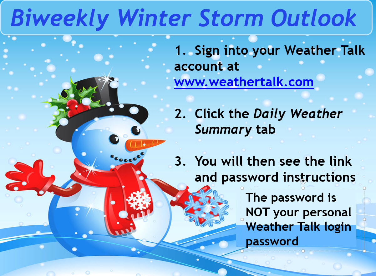
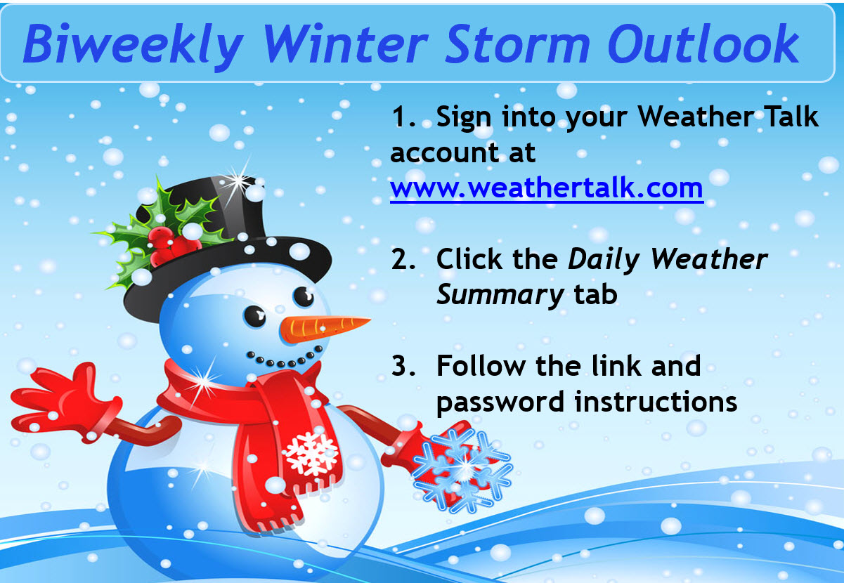
Winter storm forecasts will be posted on the www.weathertalk.com website. Look under the Daily Weather Summary tab. Forecasts begin the week of Thanksgiving.
For more information visit BeauDodsonWeather.com
Or directly sign up at Weathertalk.com


This forecast update covers far southern Illinois, far southeast Missouri, and far western Kentucky. See the coverage map on the right side of the blog…
Winter storm forecasts will be posted on the www.weathertalk.com website (under the Daily Weather Summary tab). Remember, a typical month costs me over $700 to provide you all of the data and forecasts. Your support is crucial.
The winter storm forecasts can be found under the Daily Weather Summary tab. You will also find the password there. The password will NOT be the one you use to sign into your personal weather talk account.
The winter storm outlook has been updated. The next update will be next Wednesday
..
November 29, 2016
Tuesday Night: Mostly cloudy. Showers and thunderstorms likely over our southeastern counties. The best coverage of precipitation will be over portions of western Kentucky and western Tennessee. The further south and east you travel the better the rain chances. Spotty showers are possible over far southeast Missouri and extreme southern Illinois.
What impact is expected? Some wet roadways. Lightning. Small risk for severe weather over our far southeast counties (east of LBL)
My confidence in this part of the forecast verifying: Medium. Some adjustments are possible.
Temperatures: Lows in the 40-45 degree range for portions of southeast Missouri and portions of southern Illinois. 45-50 degrees where clouds are thicker over extreme southern Illinois and western Kentucky/Tennessee
Wind Chill: N/A
Winds: Southwest at 5-10 mph. Perhaps some gusty winds. Winds may become more westerly after midnight.
What is the chance for precipitation? MO ~ 20%. IL ~ 30%. KY ~ 50% . TN ~ 50%
Coverage of precipitation: Scattered. Better coverage over our southeastern counties (east and south of the Land Between the Lakes area).
Will there be a chance for frozen precipitation? No
Is severe weather expected? There is a risk for some strong to severe storms over portions of Kentucky and Tennessee. See the severe weather outlook map further down in the blog.
Should I cancel my outdoor plans? No, but monitor radars because there could be some showers and thunderstorms over portions of the region.
Sunset will be at 4:38 p.m.
Moonrise will be at 6:40 a.m. and moonset will be at 5:11 p.m. New Moon.
Radars WEATHER RADAR PAGE – Click here —
.
Monitor the Beau Dodson Weather Facebook page and the blog for 25 days of Christmas giving! I will be giving away weather radios and some other items! There will be forty winners. Contest begins on December 1st.
.
November 30, 2016
Wednesday: Cooler. Windy, at times. Some morning clouds. Clouds may start to clear out late morning or afternoon. Low confidence on cloud cover. A few remaining showers are possible as you move towards Madisonville and Hopkinsville. Showers will end during the morning hours.
What impact is expected? Perhaps some wet roadways over our southeast counties. Gusty winds.
My confidence in this part of the forecast verifying: Medium. Some adjustments are possible.
Temperatures: High temperatures in the 46-54 degree range. Temperatures will be highly dependent on cloud cover.
Wind Chill: Temperatures may feel 5-10 degrees cooler (because of strong winds).
Winds: West at 10-20 mph. Gusty, at times. Strongest winds will probably be before 3 pm.
What is the chance for precipitation? MO ~ 10%. IL ~ 10%. KY ~ 40% TN ~ 30%
Coverage of precipitation? Perhaps a few showers over our southeast counties (Pennyrile area of western Kentucky)
Will there be a chance for frozen precipitation? No
Is severe weather expected? No
Should I cancel my outdoor plans? No, but a few showers may occur over our southeastern counties.
Sunrise will be at 6:49 a.m. and sunset will be at 4:37 p.m.
UV Index: 1-3
Moonrise will be at 7:33 a.m. and moonset will be at 5:55 p.m. Waxing Crescent
.
Wednesday Night: Partly cloudy. Chilly temperatures. Diminishing winds.
What impact is expected? Most likely none. Will monitor for patchy fog.
My confidence in this part of the forecast verifying: Medium. Some adjustments are possible.
Temperatures: Lows in the 30 to 34 degree range.
Wind Chill:
Winds: West and northwest at 6-12 mph early. Winds decreasing to below 5 mph late.
What is the chance for precipitation? MO ~ 0%. IL ~ 0%. KY ~ 0% . TN ~ 0%
Coverage of precipitation: None.
Will there be a chance for frozen precipitation? No
Is severe weather expected? No
Should I cancel my outdoor plans? No
.
December 1, 2016
Thursday: Mostly sunny and cooler.
What impact is expected? None
My confidence in this part of the forecast verifying: Medium. Some adjustments are possible.
Temperatures: High temperatures in the 45-50 degree range.
Wind Chill:
Winds: West at 5-10 mph
What is the chance for precipitation? MO ~ 0%. IL ~ 0%. KY ~ 0% . TN ~ 0%
Coverage of precipitation? None
Will there be a chance for frozen precipitation? No
Is severe weather expected? No
Should I cancel my outdoor plans? No
Sunrise will be at 6:50 a.m. and sunset will be at 4:37 p.m.
UV Index: 2-3
Moonrise will be at 8:23 a.m. and moonset will be at 6:42 p.m. Waxing Crescent
.
Thursday Night: Mostly clear and chilly.
What impact is expected? None.
My confidence in this part of the forecast verifying: Medium. Some adjustments are possible.
Temperatures: Lows in the 28-34 degree range.
Wind Chill:
Winds: West 0-5 mph
What is the chance for precipitation? MO ~ 0%. IL ~ 0%. KY ~ 0% . TN ~ 0%
Coverage of precipitation: None.
Will there be a chance for frozen precipitation? No
Is severe weather expected? No
Should I cancel my outdoor plans? No
.
December 2, 2016
Friday: A mix of sun and clouds. Cool.
What impact is expected? None
My confidence in this part of the forecast verifying: Medium. Some adjustments are possible.
Temperatures: High temperatures in the 45-50 degree range.
Wind Chill:
Winds: West at 4-8 mph
What is the chance for precipitation? MO ~ 0%. IL ~ 0%. KY ~ 0% . TN ~ 0%
Coverage of precipitation? None
Will there be a chance for frozen precipitation? No
Is severe weather expected? No
Should I cancel my outdoor plans? No
Sunrise will be at 6:51 a.m. and sunset will be at 4:37 p.m.
UV Index: 2-3
Moonrise will be at 9:12 a.m. and moonset will be at 7:34 p.m. Waxing Crescent
.
Friday Night: A few clouds. Cold.
What impact is expected? None.
My confidence in this part of the forecast verifying: Medium. Some adjustments are possible.
Temperatures: Lows in the 25-30 degree range.
Wind Chill:
Winds: West 0-5 mph
What is the chance for precipitation? MO ~ 0%. IL ~ 0%. KY ~ 0% . TN ~ 0%
Coverage of precipitation: None.
Will there be a chance for frozen precipitation? No
Is severe weather expected? No
Should I cancel my outdoor plans? No
.
December 3, 2016
Saturday: A mix of sun and clouds. Cool temperatures.
What impact is expected? None
My confidence in this part of the forecast verifying: Medium. Some adjustments are possible.
Temperatures: High temperatures in the 45-50 degree range.
Wind Chill:
Winds: West at 4-8 mph
What is the chance for precipitation? MO ~ 0%. IL ~ 0%. KY ~ 0% . TN ~ 0%
Coverage of precipitation? None
Will there be a chance for frozen precipitation? No
Is severe weather expected? No
Should I cancel my outdoor plans? No
Sunrise will be at 6:52 a.m. and sunset will be at 4:37 p.m.
UV Index: 2-3
Moonrise will be at 9:56 a.m. and moonset will be at 8:28 p.m. Waxing Crescent
.
Saturday Night: Some clouds. I will be monitoring precipitation chances as a southern storm system approaches. Precipitation type is in question, as well.
What impact is expected? Monitor updates
My confidence in this part of the forecast verifying: Low. Significant adjustments are possible.
Temperatures: Lows in the 25-30 degree range.
Wind Chill:
Winds: West 0-5 mph
What is the chance for precipitation? MO ~ 20%. IL ~ 20%. KY ~ 20% . TN ~ 20%
Coverage of precipitation: Monitor updates
Will there be a chance for frozen precipitation? Monitor updates.
Is severe weather expected? No
.
December 4, 2016
Sunday: Increasing clouds. A chance for precipitation. I will be monitoring precipitation chances.
What impact is expected? Monitor updates concerning precipitation chances.
My confidence in this part of the forecast verifying: Low. Significant adjustments are possible.
Temperatures: High temperatures in the 40-45 degree range.
Wind Chill:
Winds: West at 4-8 mph
What is the chance for precipitation? MO ~ 30%. IL ~ 30%. KY ~ 30% . TN ~ 30%
Coverage of precipitation? Monitor updates
Will there be a chance for frozen precipitation? Monitor updates.
Is severe weather expected? No
Should I cancel my outdoor plans? Monitor updates
Sunrise will be at 6:53 a.m. and sunset will be at 4:37 p.m.
UV Index: 2-3
Moonrise will be at 10:38 a.m. and moonset will be at 9:26 p.m. Waxing Crescent
.
Sunday Night: Cloudy. I will be monitoring precipitation chances.
What impact is expected?
My confidence in this part of the forecast verifying: Low. Significant adjustments are possible.
Temperatures: Lows in the 25-30 degree range.
Wind Chill:
Winds: West 0-5 mph
What is the chance for precipitation? MO ~ 30%. IL ~ 30%. KY ~ 30% . TN ~ 30%
Coverage of precipitation:
Will there be a chance for frozen precipitation? Monitor updates
Is severe weather expected? No
.
December 5, 2016
Monday: Partly cloudy.
What impact is expected?
My confidence in this part of the forecast verifying: Low. Significant adjustments are possible.
Temperatures: High temperatures in the 45-50 degree range.
Wind Chill:
Winds: West at 4-8 mph
What is the chance for precipitation? MO ~ 0%. IL ~ 0%. KY ~ 0% . TN ~ 0%
Coverage of precipitation?
Will there be a chance for frozen precipitation? No
Is severe weather expected? No
Should I cancel my outdoor plans?
Sunrise will be at 6:54 a.m. and sunset will be at 4:37 p.m.
UV Index: 2-3
Moonrise will be at 11:17 a.m. and moonset will be at 10:26 p.m. Waxing Crescent
.
Monday Night: Some increase in clouds.
What impact is expected?
My confidence in this part of the forecast verifying: Low. Significant adjustments are possible.
Temperatures: Lows in the 25-30 degree range.
Wind Chill:
Winds: West 0-5 mph
What is the chance for precipitation? MO ~ 0%. IL ~ 0%. KY ~ 0% . TN ~ 0%
Coverage of precipitation:
Will there be a chance for frozen precipitation?
Is severe weather expected? No
More information on the UV index. Click here
.
The School Bus Stop Forecast is sponsored by Heath Health and Wellness. Located next to Crowell Pools in Lone Oak, Kentucky.
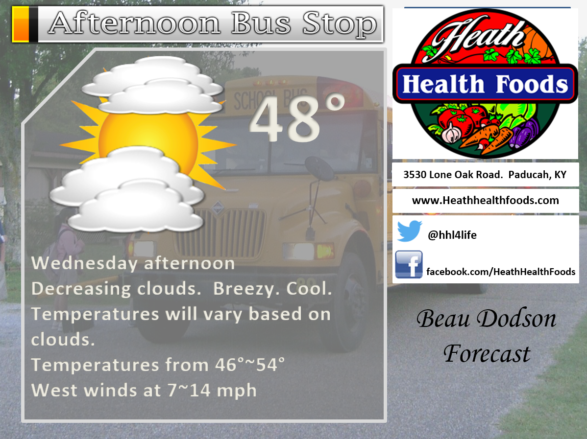
Visit their website here. And. visit Heath Health Foods on Facebook!

Heath Health Foods is a locally owned and operated retail health and wellness store. Since opening in February 2006; the store has continued to grow as a ministry with an expanding inventory which also offers wellness appointments and services along with educational opportunities. Visit their web-site here. And. visit Heath Health Foods on Facebook!
The weekend forecast is sponsored by Farmer and Company Real Estate. Click here to visit their site.
.
Farmer & Company Real Estate is proud to represent buyers and sellers in both Southern Illinois and Western Kentucky. With 13 licensed brokers, we can provide years of experience to buyers & sellers of homes, land & farms and commercial & investment properties. We look forward to representing YOU! Follow us on Facebook, as well


Don’t forget to check out the Southern Illinois Weather Observatory web-site for weather maps, tower cams, scanner feeds, radars, and much more! Click here

An explanation of what is happening in the atmosphere over the coming day
- Thoughts and prayers for those impacted by the fires
- A few showers possible Tuesday night/Wednesday morning (mostly southern and eastern counties)
- Cooler weather Wednesday night/Thursday
- Dry weather Wednesday through Saturday
- Weekend storm system?
- Watching a system around December 8th (give or take)
First, all of our thoughts and prayers are extended to those impacted by the forecast fires. Many of us have a great love for the Smoky Mountains. It is heartbreaking to see the images coming out of that area. Not only for man-made structures and livelihood, but also for the wildlife.
So many heroes. Fire fighters, police, medical, and other first responders worked through the night to help protect their communities. They were doing their jobs even while their own families were being impacted by the fires.
There are many different charities in that area that could use your help. Be sure and check some of the local news stations for information on how you can help. The ABC 6 station has been showing wall to wall coverage. That would be www.wate.com
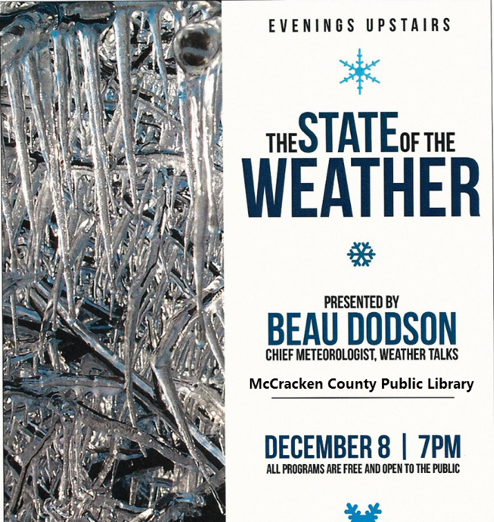
I will be speaking at the McCracken County Public Library on December 8th. Weather permitting.
Weather:
I want to remind you that weather app’s are NOT human forecasts. Your weather app (90% of them) is simply showing you what one model is forecasting.
Why not to trust your cell phone app’s weather forecast.
The GFS model has already predicted over 90″ of snow for our region since the end of October. How much has actually fallen? Correct, not one flake. Nada. Nothing. Zero. Zilch.
Computer models are not meteorologists. The app forecast you see on your phone is strictly based off the GFS model guidance. Most (not all) of the app’s are computer generated. No human interaction. This is why you can type in any city in the world and the app will give you a forecast. It is computer generated.
This includes The Weather Channel app and some of the local media app’s.
Your cell phone app will show you what the model is forecasting.
The GFS model updates four times each day. If the 6 am update shows 20″ of snow then your cell phone app will show 20″ of snow. If the 1 pm update shows 0″ of snow then your cell phone app will show 0″ of snow.
If you would have strictly followed your app forecast, over the past couple of months, then snow lovers would have been disappointed multiple times over.
There are some articles floating around predicting snow on December 9th. Will it snow on December 9th? I have no idea. Why do I have no idea? Because meteorologists can’t forecast 10 days in advance (with any confidence). Could there be snow? Sure, there could be. Could there be rain? Sure, there could be.
The models show a system around that time. Some track the system way north. Some track it way south. Some show rain, some show snow, some show no precipitation at all.
What if I would have told you about each one of the GFS snow events? Those who hate snow would be stressed out. Those who love snow would hate me!
Current Weather:
Cloud cover was once again a pain to forecast today. Yesterday it appeared the sun would win out today. It was obvious this morning, at least for portions of the region, that the clouds were not going to leave.
This is me trying to forecast cloud cover during the autumn months.

It is difficult, during November, for clouds to scour out. Actually, fall and winter months. Low level moisture can become trapped and lead to thick clouds. Cloud cover is always difficult to forecast during this time of the year. This also impacts temperatures. Where clouds are thicker you can shave 4-8 degrees (or more) off the thermometer.
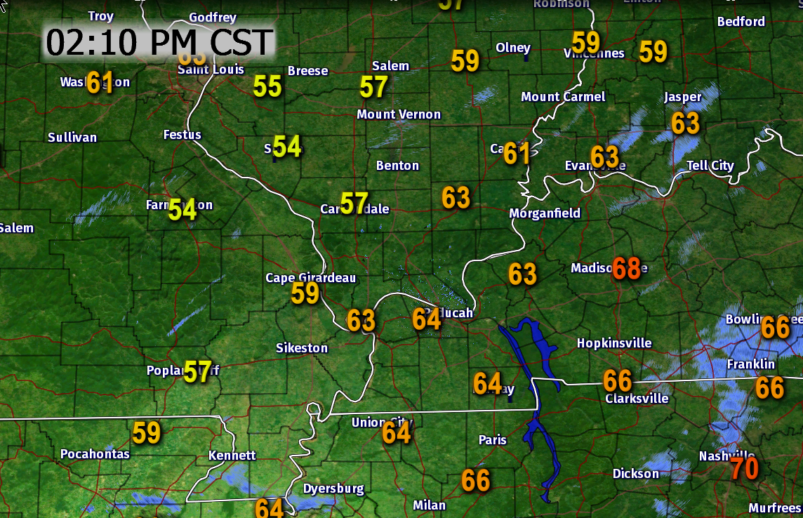
Portions of our region reached well into the 60’s today. Parts of the region remained in the 50’s. Here is the 2 PM temperature map (Tuesday afternoon)
Big difference from north to south.
Overnight storm system:
Tuesday night into Wednesday morning.
An area of low pressure will push through the Tennessee Valley tonight into Wednesday morning. Heavy rain is anticipated east of our local area. Some of the showers will likely push as far northwest as western Tennessee and western Kentucky. The greatest chance for rain will occur over our southeast counties. That would include areas along and east of a line from Madisonville to Hopkinsville. Along that line and east/southeast of that line will have the best chance for rain and storms.
Areas to the northwest of that line may receive a few spotty showers. The coverage won’t be as great as the above mentioned area.
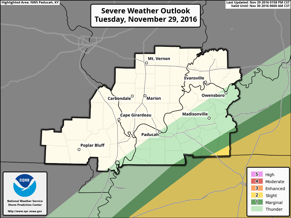
The models also show some potential for a few thunderstorms as you move towards south central Kentucky. Mostly our extreme southeastern counties. Here is the severe weather outlook from the Storm Prediction Center/NOAA.
The dark green and yellow zone is where a few strong to severe storms may occur. The overall severe weather risk is small, but not zero.
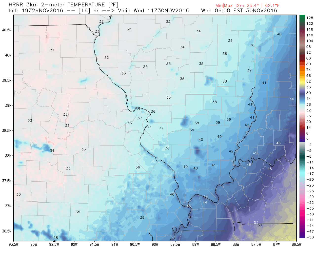
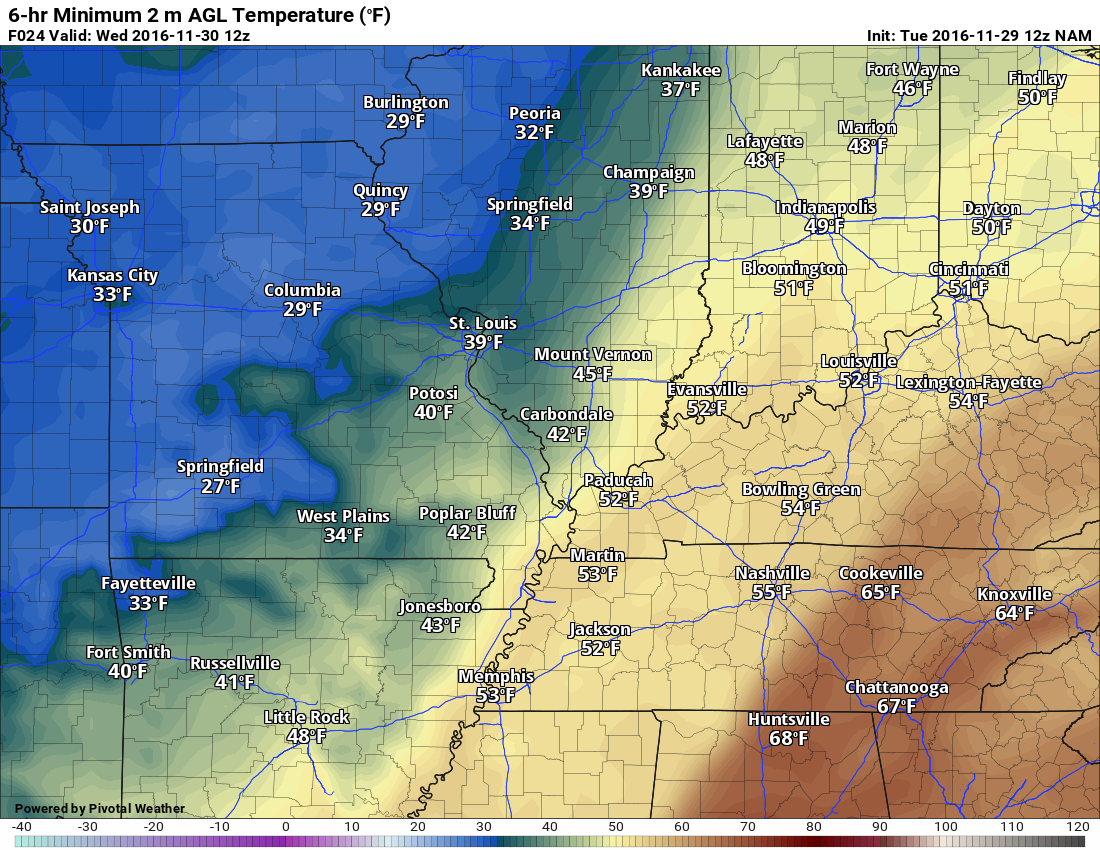
There will be a bit of the range temperature wise. Northwest counties may dip into the 30’s. Southeast counties may dip into the upper 40’s.
Here is the forecast temperature map for 4 or 5 am on Wednesday.
Click images for a larger view.
Southeast view

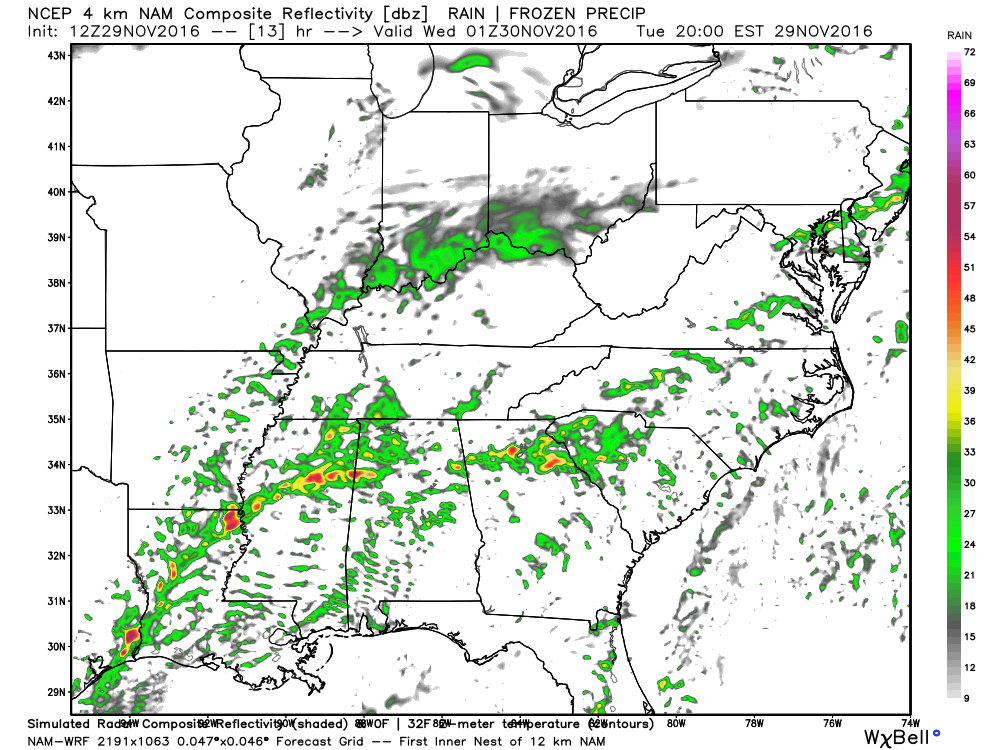
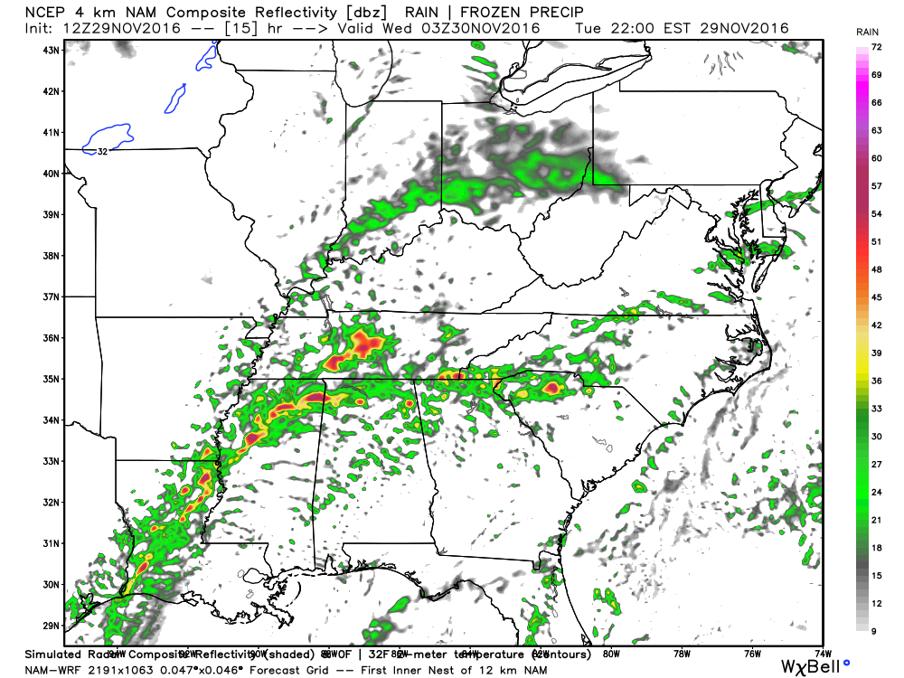
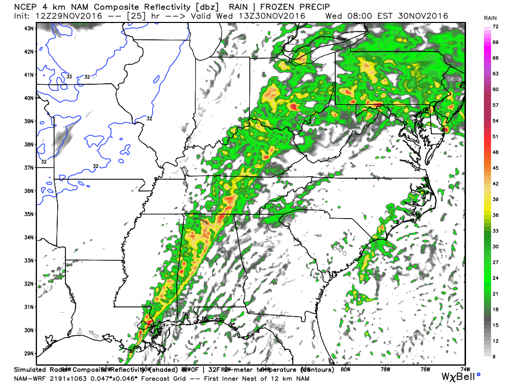
Here is what the WRF model guidance is showing for the rain event tonight into Wednesday morning. This is the future-cast radar.
The colors represent rain showers. Yellow and red would be heavier rain.
This first image is for 7 pm tonight. The NAM guidance does spread a few showers into our area. The NAM might be a bit too far north and west. It is also possible some of this rain is so light that it won’t make it to the ground.
Some of this precipitation may not even reach the ground because of evaporation. This is one reason radar occasionally shows precipitation, but nothing is actually falling from the sky. Remember, the radar beam can be thousands of feet aloft (depending on where you live in relation to the radar).
As always, click images for a larger view.
This next image is for 9 pm Tuesday night. Again we will have to see how far northwest the rain spreads. Better chances further south and southeast.
This next image is for 11 pm Tuesday night.

This next image is for 1 am on Wednesday.
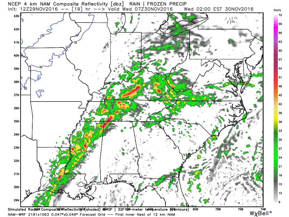
This next image is for 3 am Wednesday.
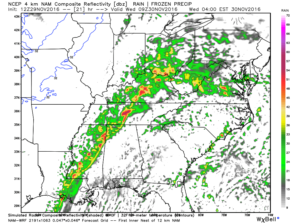
This next image is for 5 am Wednesday.
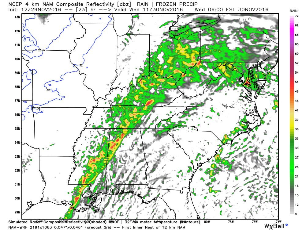
This next image is for 7 am on Wednesday.
Even if the rain moves into portions of our region, it won’t last long.
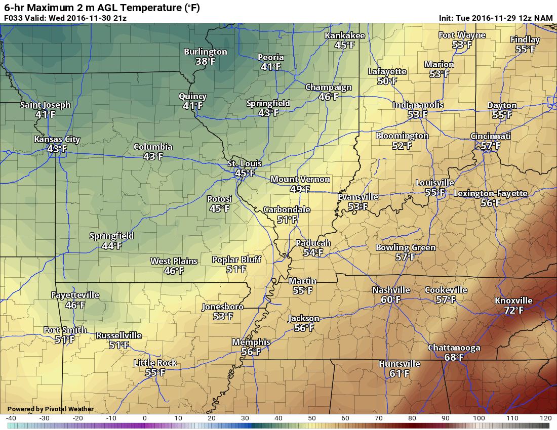
Wednesday should deliver a mix of sun and clouds. Again, perhaps some morning showers over our eastern and southeastern counties. The clouds will linger longest over the Pennyrile area of western Kentucky.
I am hoping that clouds will clear on Wednesday late morning and afternoon. Confidence is lower than normal concerning cloud cover. Cloud cover will impact temperatures, of course.
Here is what the WRF model shows for Wednesday afternoon temperatures.
As always, click images for a larger view.

Wednesday night into Friday will be dry. Cool temperatures, but nothing extreme.
Perhaps some clouds on Friday/Friday night.
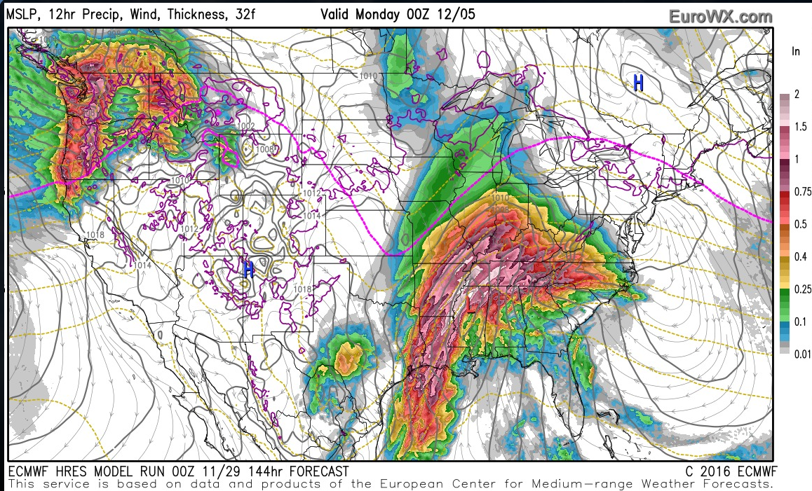
A large storm system, with widespread precipitation, will move towards our region on Saturday night into Sunday night. Model guidance has mixed ideas on how far north and west the rain will extend. I have introduced rain chances for a portion of the weekend. Lower than normal confidence on the weekend forecast. Monitor updates if you have outdoor events on Saturday night into Sunday night.
Some of the models are showing freezing rain, sleet, or snow. It is too early to make a forecast on precipitation type. Monitor updates.
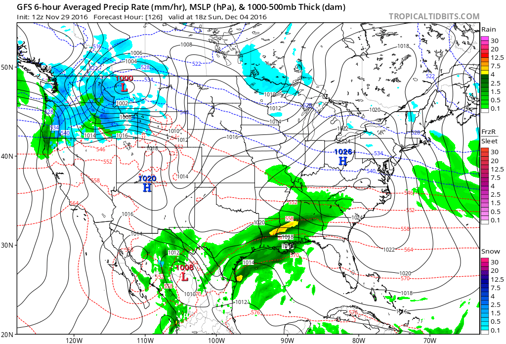
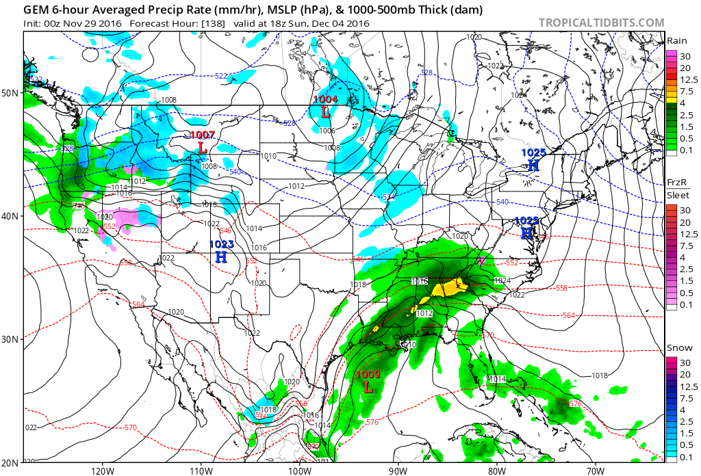
The EC model guidance is the most bullish with the Sunday system. The GEM model guidance shows rain and snow. The GFS shows the system barely clipping our local area.
Here are a few graphics
This first graphic is the GFS model. This map is for 12 pm on Sunday. It shows a system well to our south. The GFS brushes our region with some light rain.
This next graphic (below) is the Canadian GEM model guidance. There are many different models that meteorologists use when putting together a forecast.
The GEM guidance is colder and shows rain/snow. Perhaps a wintry mix.
Finally, the EC guidance shows heavy rain. Typically a blend of the GFS and EC makes for a decent forecast. If that is the case, with this rain event, then showers will likely occur by Sunday into Sunday night.
Again, models are not in agreement on the forecast for Sunday. It is still several days away. Monitor updates if you have concerns.
So which model will be correct? Great question. Models don’t do very well with active patterns. Active meaning frequent storm systems moving through the jet stream flow. We are certainly in an active pattern. Storm systems every few days.
Model guidance will likely come into better agreement as we move through the week. Plan on at least some precipitation by Saturday night or Sunday/Sunday night. Coverage and intensity will need to be fine tuned. Still several days to monitor trends.
I am carefully monitoring late next week for another storm system. Too early to know whether it would be rain or snow. Monitor updates.
A new winter storm forecast will be posted on Wednesday evening. Directions on where to view the winter storm forecasts can be viewed below.
Also, I will be announcing our 25 days of Christmas giving! You can enter up to 25 times. Monitor this page and the Beau Dodson Weather Facebook page.
WINTER STORM UPDATE:
I have updated the winter storm outlook. The second of the season. The winter storm outlook will be posted twice a week.
You can view the forecast by following these instructions. Remember, the winter storm outlook is behind the paywall. It is $3 a month. A typical months worth of expenses is $700.00 or more. This helps offset the costs.
The next winter storm update will be posted on Wednesday, November 30th.
To sign up for the text messages you can visit www.beaudodsonweather.com
Find me on Twitter, as well!
.
.
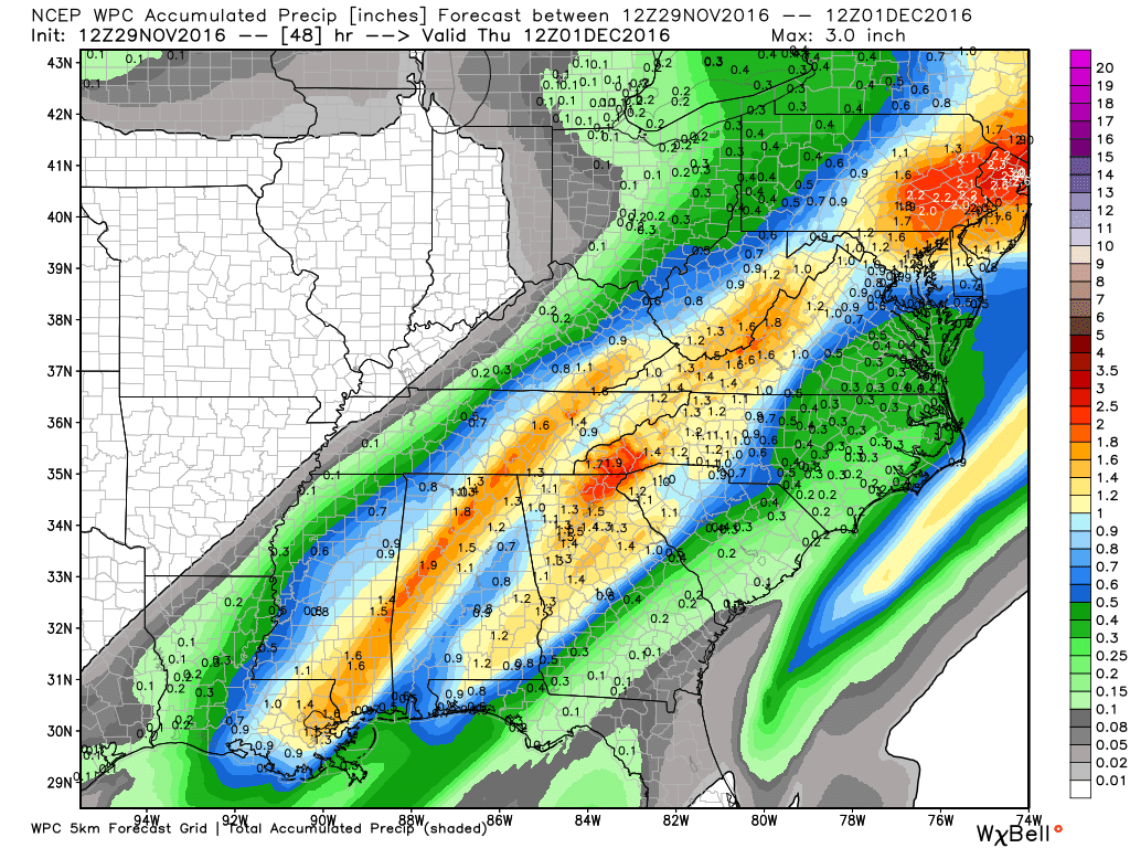
How much rain is expected over the coming days?
Some rain may fall over the area Tuesday night/Wednesday morning. The best chance will be over Kentucky and Tennessee. Chances are less for southeast Missouri and southern Illinois.
This first image is the official NOAA/WPC rainfall forecast graphic. Notice how most of the rain is to our east.
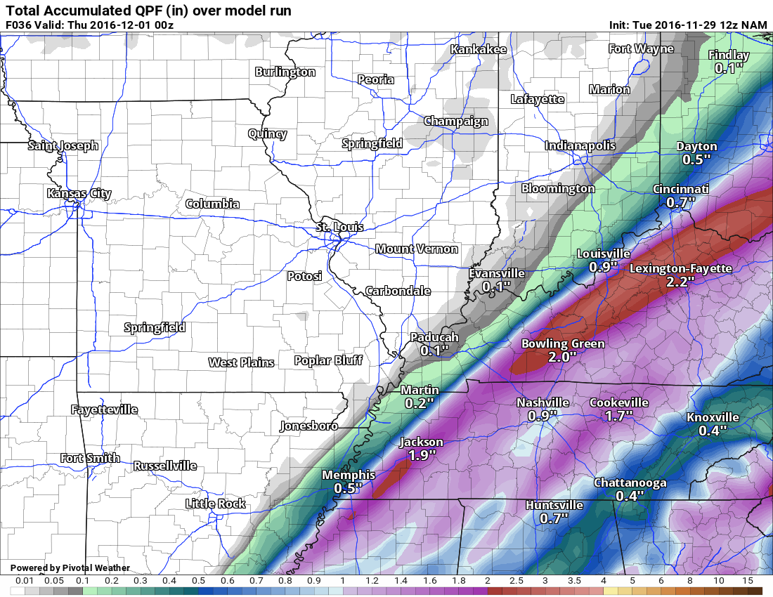
Here are two models. The first one is the GFS and the second one is the GEM.
GFS model rainfall totals for the Wednesday event. Notice how far east and southeast the precipitation will be. Perhaps missing our area.
Click image to enlarge

GEM model rainfall totals for the Wednesday event
Click image to enlarge

One more, for good measure. The NAM model guidance
.
.
Temperature Outlook
Wednesday morning low temperatures
..
.
Wednesday afternoon 4 pm temperatures
.
.
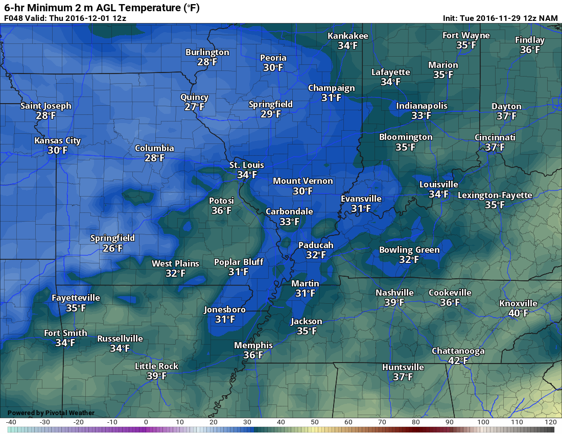
Thursday morning low temperatures
.
.
.
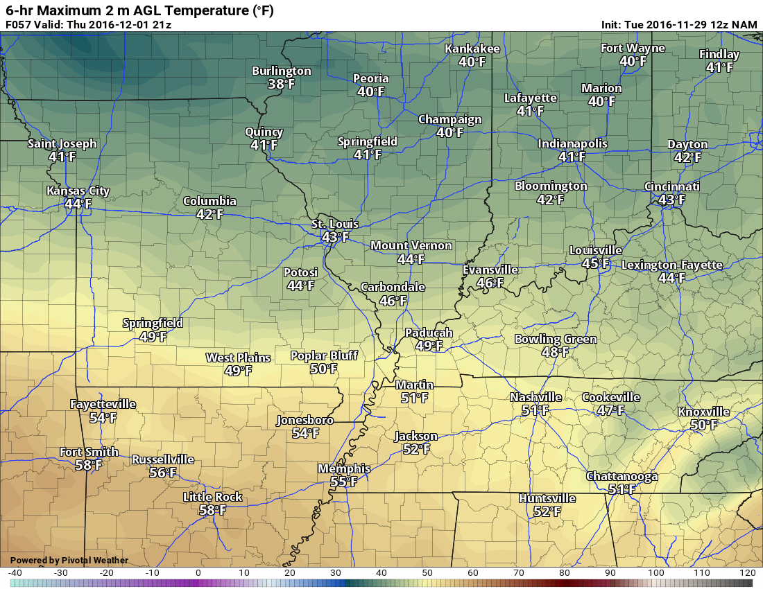
Thursday afternoon temperatures at 4 pm
.
.
.
Regional Radar
 .
.
.
.

We have regional radars and local city radars – if a radar does not seem to be updating then try another one. Occasional browsers need their cache cleared. You may also try restarting your browser. That usually fixes the problem. Occasionally we do have a radar go down. That is why I have duplicates. Thus, if one fails then try another one.
If you have any problems then please send me an email beaudodson@usawx.com
WEATHER RADAR PAGE – Click here —
We also have a new national interactive radar – you can view that radar by clicking here.
Local interactive city radars include St Louis, Mt Vernon, Evansville, Poplar Bluff, Cape Girardeau, Marion, Paducah, Hopkinsville, Memphis, Nashville, Dyersburg, and all of eastern Kentucky – these are interactive radars. Local city radars – click here
.

Live Lightning Data – zoom and pan: Click here
Live Lightning Data with sound (click the sound button on the left side of the page): Click here

Can we expect severe thunderstorms over the next 24 to 48 hours? Remember that a severe thunderstorm is defined as a thunderstorm that produces 58 mph winds or higher, quarter size hail or larger, and/or a tornado.
Tuesday night through Sunday: Severe weather is not anticipated.
.
.
No significant adjustments.
.

.
Perhaps some thunderstorms over south central Kentucky.
.
..
.


.
The latest 8-14 day temperature and precipitation outlook. Note the dates are at the top of the image. These maps DO NOT tell you how high or low temperatures or precipitation will be. They simply give you the probability as to whether temperatures or precipitation will be above or below normal.
.

 .
..

Here are the current river stage forecasts. You can click your state and then the dot for your location. It will bring up the full forecast and hydrograph.

Who do you trust for your weather information and who holds them accountable?
I have studied weather in our region since the late 1970’s. I have 38 years of experience in observing our regions weather patterns. I hold a Bachelor’s of Science in Geo-sciences with a concentration in Broadcast Meteorology. I graduated from Mississippi State University.
My resume includes:
Member of the American Meteorological Society.
NOAA Weather-Ready Nation Ambassador.
Meteorologist for McCracken County Rescue Squad. I served from 2005 through 2015
Meteorologist for the McCracken County Rescue Squad 2015-current
I own and operate the Southern Illinois Weather Observatory.
Recipient of the Mark Trail Award, WPSD Six Who Make A Difference Award, Kentucky Colonel, and the Caesar J. Fiamma” Award from the American Red Cross.
In 2009 I was presented with the Kentucky Office of Highway Safety Award.
Recognized by the Kentucky House of Representatives for my service to the State of Kentucky leading up to several winter storms and severe weather outbreaks.
I am also President of the Shadow Angel Foundation which serves portions of western Kentucky and southern Illinois.
There is a lot of noise on the internet. A lot of weather maps are posted without explanation. Over time you should learn who to trust for your weather information.
My forecast philosophy is simple and straight forward.
- Communicate in simple terms
- To be as accurate as possible within a reasonable time frame before an event
- Interact with you on Twitter, Facebook, and the blog
- Minimize the “hype” that you might see on television or through other weather sources
- Push you towards utilizing wall-to-wall LOCAL TV coverage during severe weather events
I am a recipient of the Mark Trail Award, WPSD Six Who Make A Difference Award, Kentucky Colonel, and the Caesar J. Fiamma” Award from the American Red Cross. In 2009 I was presented with the Kentucky Office of Highway Safety Award. I was recognized by the Kentucky House of Representatives for my service to the State of Kentucky leading up to several winter storms and severe weather outbreaks.
If you click on the image below you can read the Kentucky House of Representatives Resolution.

Many of my graphics are from www.weatherbell.com – a great resource for weather data, model data, and more


You can sign up for my AWARE email by clicking here I typically send out AWARE emails before severe weather, winter storms, or other active weather situations. I do not email watches or warnings. The emails are a basic “heads up” concerning incoming weather conditions.